Browse Listings in America > North America
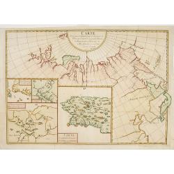
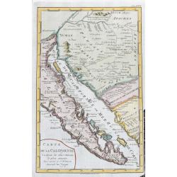
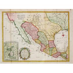
Carte de la Californie Suivant.
A historically important depiction of the 5 most influential cartographic depictions of California, showing the evolution of how California was mapped between 1604 and 17...
Date: Paris, 1772
Selling price: ????
Please login to see price!
Sold in 2017
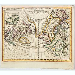
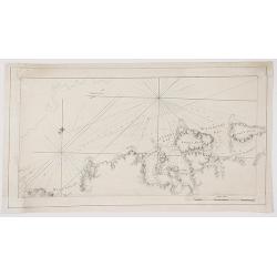
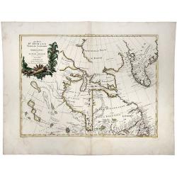
Carte generale des Decouvertes de L'Amiral de Fonte. . .
An interesting map of the northwest coast, showing de L'Isle's conjectural northwest coast, based upon that of de Font and Russian Discoverers, including the Bay of the W...
Date: Paris, 1772
Selling price: ????
Please login to see price!
Sold in 2020
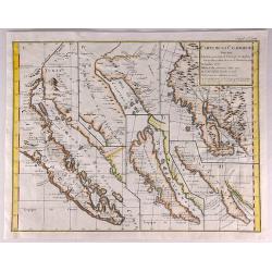
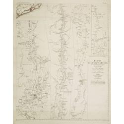
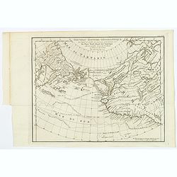
Carte de la partie Septentrionale et Orientale .. (5 maps on one sheet)
Five maps on one sheet, showing California, Alaska and Siberia and Japan.Map I showing Alaska, California as a peninsular, eastern tip of Japan with a curious Islade Plat...
Date: Paris, 1772
Selling price: ????
Please login to see price!
Sold in 2023
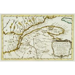
Carte du cours du Fleuve de St.Laurent..
Uncommon edition of this accurate map showing the lower St.Laurence. Second state.From Atlas Portatif pour servir a l'intelligence de l'Histoire Philosophique et Politiqu...
Date: Amsterdam 1773
Selling price: ????
Please login to see price!
Sold
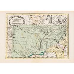
Carte de la Louisiane et Pays Voisins..
Uncommon edition of this accurate map centered on Louisiana and extending eastwards as far as the Atlantic seacoast. In lower right engraved "33."From Atlas Por...
Date: Amsterdam, 1773
Selling price: ????
Please login to see price!
Sold in 2019
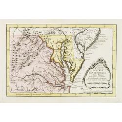
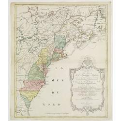
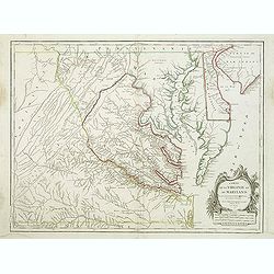
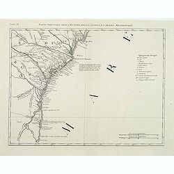
Carte de la Virginie et du Maryland, ou de la Baie de Chesapeack et pays voisins..
Uncommon edition of this accurate map showing Chesapeake Bay and part of New Jersey, Philadelphia and part of Virginia. In lower right engraved "39."From Atlas ...
Date: Amsterdam, 1773
Selling price: ????
Please login to see price!
Sold
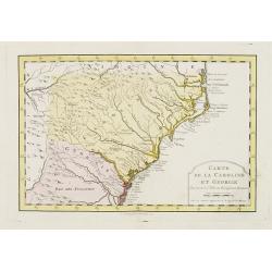
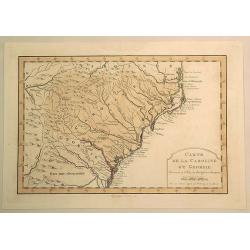
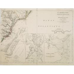
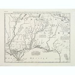
Carte de la Caroline et Georgie..
Uncommon edition of this early map of the Carolinas. In lower right engraved "40."From Atlas Portatif pour servir a l'intelligence de l'Histoire Philosophique e...
Date: Amsterdam, 1773
Selling price: ????
Please login to see price!
Sold
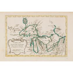
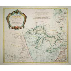
Carte des Lacs du Canada..
Scarce edition of this accurate map showing the all the Great Lakes in the traditional Bellin configuration.Kershaw does not mention this state with in lower right corner...
Date: Amsterdam, 1773
Selling price: ????
Please login to see price!
Sold in 2014
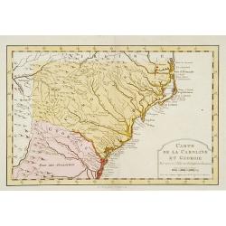
Carte de la Caroline et Georgie.
Fine hand-colored Bellin atlas map of the Southern States Georgia and Carolina from Curriluk Pass to Kekil Island. Out of "Atlas Portalif ". A plain title carto...
Date: Paris, 1773
Selling price: ????
Please login to see price!
Sold in 2020
Carte de la Caroline et Georgie. . .
Uncommon edition of this early map of the Carolinas.From Atlas Portatif pour servir a l'intelligence de l'Histoire Philosophique et Politique des etablissements et du com...
Date: Amsterdam, 1773
Selling price: ????
Please login to see price!
Sold in 2016
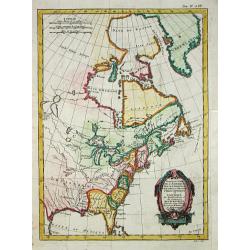
Partie du Nord de l' Amerique Septentrionale.
Rigobert Bonne (1727-1795), French cartographer. His maps are found in a.o. Atlas Moderne (1762), Raynal's Histoire Philos. du Commerce des Indes (1774) and Atlas Encyclo...
Date: Paris, 1774
Selling price: ????
Please login to see price!
Sold
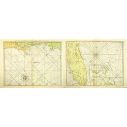
The Coast of West Florida and Louisiana. (together with) The Peninsula and Gulf of Florida or Channel of Bahama with the Bahama Islands.
Two nautical charts showing of the coast of West Florida and Louisiana, together with the Peninsula and Gulf of Florida or Channel of Bahama with the Bahamas Islands. Dep...
Date: London, Sayer and Bennett, 1775
Selling price: ????
Please login to see price!
Sold in 2012
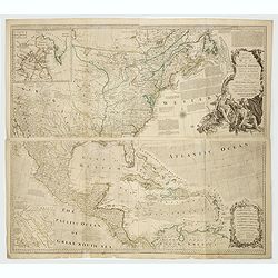
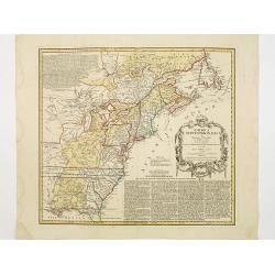
An Accurate Map of North America. Describing and Distinguishing the British and Spanish Dominions on this Great Continent. According to the Definitive Treaty Concluded at Paris 10th Feb. 1763.
The outstanding British map of North America created on the eve of the American Revolution, this is the desirable fourth Robert Sayer (1725-1794) issued 1775 edition of B...
Date: London, Robert Sayer, 1775
Selling price: ????
Please login to see price!
Sold in 2022
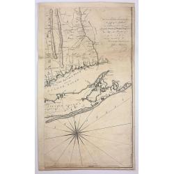
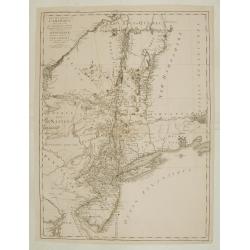
A Map of the Province of New York, With Part of Pensilvania and New England, from and Actual survey by Captain Montressor, Engineer, 1775
The Most Important Map of the British Colony of New York produced during the American Revolution.The purpose of Montressor's large scale map was for military rather than ...
Date: London, 1775
Selling price: ????
Please login to see price!
Sold in 2017

The Parricide. A Sketch of Modern Patriotism. Westminster Magazine, vol. IV, 1st May 1776.
Britannia attacked by America and the British lion.Reaction against ministers who supported the American cause. Images include: John Wilkes (1725-1797); America as a woma...
Date: London, 1776
Selling price: ????
Please login to see price!
Sold in 2018
Carte Nouvelle de l'Amerique Angloise Contenant tout ce que les Anglois Possedent sur le Continent de l'Amerique Septentrionale Savoir le Canada, la Nouvelle Ecosse ou Acadie, les Treize Provinces Unies...
This fine and large map was issued shortly before the outbreak of the American Revolution and was included in Lotter's Atlas Geographique. The map covers the region from ...
Date: Augsburg, 1776
Selling price: ????
Please login to see price!
Sold in 2019
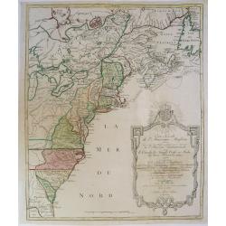
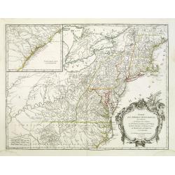
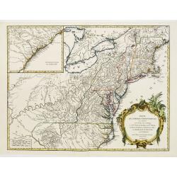
A map of the middle British colonies in North America.
A separately published copper engraving in one sheet. The map shows geography from the mouth of the Delaware to the eastern edge of New York; inland, it shows the Susqueh...
Date: London, 1776
Selling price: ????
Please login to see price!
Sold
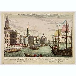
Debarquement des troupes engloises a nouvelle York.
A so-called optical print showing a fanciful view of British troops disembarking at New York City. Built environment includes churches, dwellings, ships, and boats.
Date: Augsburg, 1776
Selling price: ????
Please login to see price!
Sold in 2013
![[ Narraganset Bay and Rhodes Island and Harbour. ]](/uploads/cache/44824-250x250.jpg)
[ Narraganset Bay and Rhodes Island and Harbour. ]
A chart of Narraganset Bay and part of Rhode Island, taken from the "Atlantic Neptune", and marked in lower left corner "Published according to Act of Parl...
Date: London, 1776
Selling price: ????
Please login to see price!
Sold in 2019
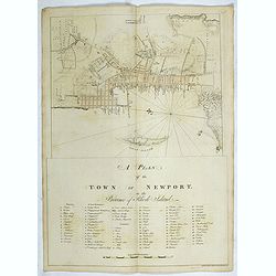
A plan of the Town of Newport in the province of Rhode Island.
A plan of the Town of Newport in the province of Rhode Island, taken from the "Atlantic Neptune", and marked in lower left corner "Published according to A...
Date: London, 1776
Selling price: ????
Please login to see price!
Sold in 2019
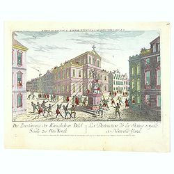
La Destruction de la Statue royale a Nouvelle Yorck.
A famous Revolutionary War optical prints, depicting the Sons of Liberty tearing down a statue of King Georg III at Bowling Green in New York.The image shows depict the e...
Date: Augsburg, 1776
Selling price: ????
Please login to see price!
Sold in 2016
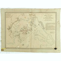
A Plan of Boston, and its Environs, shewing the true Situation of His Majesty's Army. And also those of the Rebels. Drawn by an Engineer at Boston. Octr. 1775.
An important plan of the Siege of Boston, based on a survey by a British officer present during the Siege, with details relating to fortifications, the disposition of for...
Date: London, 1776
Selling price: ????
Please login to see price!
Sold in 2018
![[Nantucket Island and the west end of Martha's Vineyard]](/uploads/cache/44826-250x250.jpg)
[Nantucket Island and the west end of Martha's Vineyard]
A chart of Nantucket Island, taken from the "Atlantic Neptune", and marked in lower left corner "Published according to Act of Parliament June 1st, 1776 by...
Date: London, 1776
Selling price: ????
Please login to see price!
Sold in 2019

Débarquement des Troupes Angloises à Nouvelle Yorck.
So-called optical print which shows English troops landing in New York City during the Revolution prior to the conquest of the city. With reversed title in French along t...
Date: Paris, 1776
Selling price: ????
Please login to see price!
Sold in 2011
Carte Nouvelle de L'Amerique Angloise..
Large, beautiful and detailed map of the Eastern Seaboard, from Northern Florida to Newfoundland, including numerous Indian tribal lands and showing the British colonies ...
Date: Augsburg 1776
Selling price: ????
Please login to see price!
Sold
![[ Buzzards Bay, Martha's Vineyard, Nantucket Island ]](/uploads/cache/44827-250x250.jpg)
[ Buzzards Bay, Martha's Vineyard, Nantucket Island ]
A chart of Buzzards Bay, Martha's Vineyard and Nantucket Island, taken from the "Atlantic Neptune", and marked in lower left corner "Published according to...
Date: London, 1776
Selling price: ????
Please login to see price!
Sold in 2019
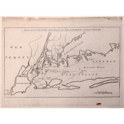
Sketch of the Country Illustrating the Late Engagement in Long Island.
An interesting map of Colonial New York.This is the first edition of this map that shows the troop positions and battle activity of this early American Revolution battle....
Date: London, October 1776
Selling price: ????
Please login to see price!
Sold in 2015
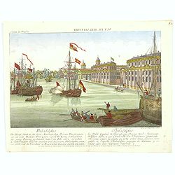
Vue de Philadelphie.
An attractive optical prints of Philadelphia, the capital of Pennsylvania, and the future fledgling nation's capital, during the Revolutionary war with Britain. A harbour...
Date: Augsburg, 1776
Selling price: ????
Please login to see price!
Sold in 2016
Vuë de la Nouvelle Yorck. Neu Yorck. Eine Stadt in Nord-America auf einer Insul Manatthan.
Fascinating optical print with a view of the harbor in New York, showing an idealized image of Manhattan at the outbreak of the American Revolutionary-War.Read more about...
Date: Augsburg, 1776
Selling price: ????
Please login to see price!
Sold in 2023

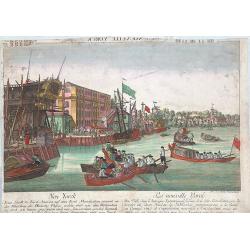
Le débarquement des troupes anglaises à New York.
The landing of the English troops in New York in September 1776. A so-called optical print. In the eighteenth and nineteenth centuries there were many popular speciality ...
Date: Paris, 1776
Selling price: ????
Please login to see price!
Sold
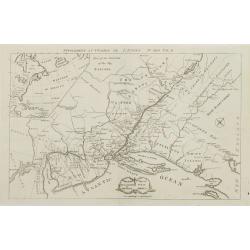
Partie Occidentale du Canada et Septentrionale de la Louisiane..
Fine copper engraved map of the Great Lakes region after d'Anville's, to whom Santini gives credit in the cartouche.The map extends from the upper Mississippi River valle...
Date: Venice, 1776
Selling price: ????
Please login to see price!
Sold in 2009
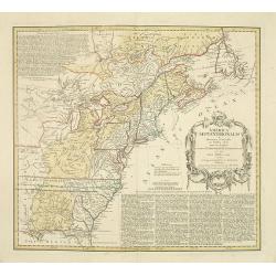
Amerique Septentrionale avec les Routes, Distances en miles, Villages et Etablissements François et Anglois Par le Docteur Mitchel Traduit de l'Anglois ... Corigee en 1776 par M. Hawkins... Verbessert 1776
Second impression of third French edition of the famous John Mitchell map of the British and French Dominions in North America which was first published in 1755. Title in...
Date: Paris, 1776
Selling price: ????
Please login to see price!
Sold
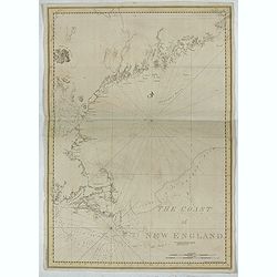
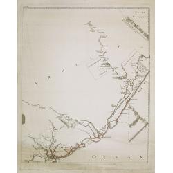
The Coast of New England.
A chart of New England Coast, taken from the "Atlantic Neptune", and marked in lower left corner "Published according to Act of Parliament April 24th, 1776...
Date: London, 1776
Selling price: ????
Please login to see price!
Sold in 2019
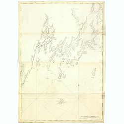
St Georges River (Owls head)
A chart of part of Maine, showing Knox County, Lincoln County and St Georges River taken from the "Atlantic Neptune", and marked in lower right corner "Pub...
Date: London, 1776
Selling price: ????
Please login to see price!
Sold in 2015
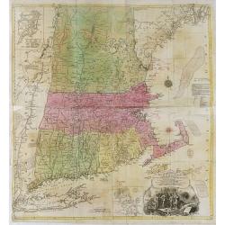
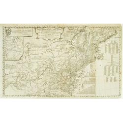
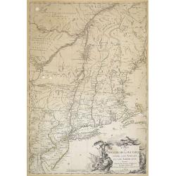
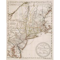
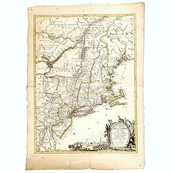
A map of the most inhabited part of New England, containing the provinces of Massachusetts Bay and New Hampshire, with the colonies of Konektikut and . . .
A separately published copper engraving in four sheets, 96.5 x 100cm. This is the second plate by Probst after the Jefferys-Green map.With an imposing title, cartouche up...
Date: Augsburg, 1777
Selling price: ????
Please login to see price!
Sold in 2016
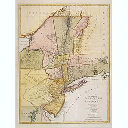
A Map of the Provinces of New-York and New-Jersey, with a Part of Pennsylvania and the Province of Quebec. from the Topographical Observations of C.J. Sauthier.
This map afforded British commanders during the Revolutionary-War an excellent overview of areas that would be crucial in the early years of the war, in particular the Hu...
Date: Augsburg, 1777
Selling price: ????
Please login to see price!
Sold in 2013
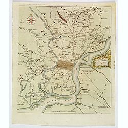
A Map of Philadelphia and Parts Adjacent.
A nice example of the 1777 Revolutionary War edition of the Scull & Heap map of Philadelphia, published by the Gentleman's Magazine. The Scull & Heap map went thr...
Date: London, 1777
Selling price: ????
Please login to see price!
Sold in 2019
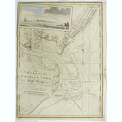
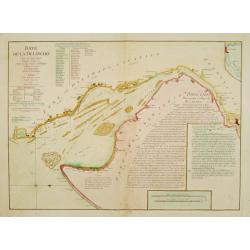
The Harbour of Charles Town in South-Carolina from the Surveys of Sr. Jas. Wallace Captn. in his Majesty Navy & Others, with A View of the Town from the South Shore of Ashley River.
A chart of Charles Town's Harbour in South Carolina, with in upper left part a view of Charles Town (present-day Charleston), South Carolina, from the north-eastern shore...
Date: London, 1777
Selling price: ????
Please login to see price!
Sold in 2019
Baye de la Delaware.
Chart showing the Delaware Bay and port of Philadelphia, prepared by Joshua Fisher?s, re-issued by Le Rouge in Paris. North is oriented to the right. The sailing chart sh...
Date: Paris 1777
Selling price: ????
Please login to see price!
Sold
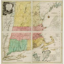
A map of the most inhabited part of NEW ENGLAND..
A separately published copper engraving in four sheets, 96.5 x 100cm. This is the second plate by Probst after the Jeffery's-Green map.With an imposing title cartouche up...
Date: Augsbourg, 1777
Selling price: ????
Please login to see price!
Sold
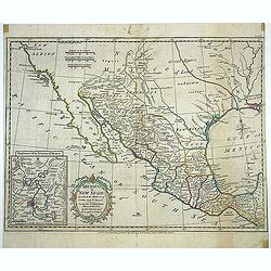
A new map of Mexico or New Spain in which the Motions of Cortes may be traced. . .
Map shows provinces of New Spain, [Baja] California, "New Albion." New Mexico and Louisiana are shown separated by "Great Space of Land unknown." Area...
Date: London, Strahan, T.Cadell, ca. 1777
Selling price: ????
Please login to see price!
Sold in 2013
America Septentrionalis a Domino d'Anville..
The map is throughly annotated in German. Interesting map of the Colonies at the outset of the French & Indian War. Some of the interesting features include a truncat...
Date: Nuremberg 1777
Selling price: ????
Please login to see price!
Sold
A map of the provinces of New-York and New-Jersey..
This map afforded British commanders during the Revolution an excellent overview of areas that would be crucial in the early years of the war, in particular the Hudson Va...
Date: Augsburg 1777
Selling price: ????
Please login to see price!
Sold
Caroline
Le Rouge's version of this important large-scale map of Claude Sauthier's map of the course of the Hudson River. The map was the inset map of a 4 sheet map entitled "...
Date: Paris, 1777
Selling price: ????
Please login to see price!
Sold in 2012
Theatre de la guerre en Amerique. Seat of war in America.
RARE. This map of uncertain date and origin is oriented with northeast at the top, with a banner Supplement au Courier de L\'Europe No. XXXII Vol. II, apparently a French...
Date: London, 1777
Selling price: ????
Please login to see price!
Sold in 2009
Carte du Theatre de la Guerre Entre les Anglais et les Americains...
This is an important separately published French map of the northern American colonies at the beginning of the American Revolution.Here in a proof- state !, later issued ...
Date: Paris, Esnauts et Rapilly, 1777
Selling price: ????
Please login to see price!
Sold in 2011
Carte De La Californie...
Map of Baja California, parts of Mexico, and Arizona. Very detailed with settlements, mountains, islands, missions, Indian tribes (Apache, Pericu, Yuma and Cochimi). Thi...
Date: Amsterdam, 1777
Selling price: ????
Please login to see price!
Sold in 2020
A Chart of New York Island & North River: East River, Passage Through Hell's Gate, Flushing Bay, Hampstead Bay ...... (Fragment Only)
This is a fragment of a very important, large chart. It was produced by Joseph Des Barres in London in 1777. The full map shows Long Island north shore from Eaton’s N...
Date: London, 1777
Selling price: ????
Please login to see price!
Sold in 2017
Cours de la rivière d'Hudson avec la communication avec le Canada par le Lac Champlain jusqu'au Fort Chambly par Sauthier a 4 Mmiles pour pouce anglois.
Le Rouge's version of this important large-scale map of Claude Sauthier's map of the course of the Hudson River. The map was the inset map of a 4 sheet map entitled "...
Date: Paris, 1777
Selling price: ????
Please login to see price!
Sold in 2008
Caroline Septentrionalr et Meridionale en 4 Feuilles . . .
Le Rouge\'s version of this important large scale map of North Carolina. One sheet of four from a very rare wall map. The lower right sheet only; showing the coastline ar...
Date: Paris, 1777
Selling price: ????
Please login to see price!
Sold in 2008
![[Page from \"Caroline Septentrionalr et Meridionale en 4 Feuilles . . .\"]](/uploads/cache/26346-250x250.jpg)
[Page from \"Caroline Septentrionalr et Meridionale en 4 Feuilles . . .\"]
One sheet of four from the Le Rouge\'s version of this important large scale map of North Carolina. The lower left sheet showing the coastline south of Charlestown and la...
Date: Paris, 1777
Selling price: ????
Please login to see price!
Sold in 2008
![[Page from "Caroline Septentrionalr et Meridionale en 4 Feuilles . . ."]](/uploads/cache/26347-250x250.jpg)
[Page from "Caroline Septentrionalr et Meridionale en 4 Feuilles . . ."]
One sheet of four from the Le Rouge's version of this important large scale map of North Carolina. The upper right sheet showing the coastline of Corolina with Pamticoe S...
Date: Paris, 1777
Selling price: ????
Please login to see price!
Sold in 2008

A plan of the City and Environs of Philadelphia. . .
The Lotter edition of Scull & Heap's seminal Philadelphia map, which map was first issued in 1752.Holmes' grid plan for the city is shown, situated between the rivers...
Date: Augsburg, 1777
Nouveau Systeme Geographique par lequel on concilie les anciennes connoissances sur les Pays Nord-Ouest de l'Amerique avec les nouvelles decouvertes des Russes au Nord de la Mer du Sud.
An extremely rare and virtually unknown Dutch edition of De Vaugondy's map, published in Amsterdam by Krevelt in 1777. De Vaugondy's Final Chapter In The Greatest Cartogr...
Date: Amsterdam, 1777
Selling price: ????
Please login to see price!
Sold in 2018
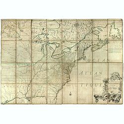
Amerique septentrionale avec les Routes, Distances en miles, Villages et Etablissements François et Anglois. Par le Docteur Mitchel Traduit de l'Anglois ... Corigee en 1776 par M. Hawkins..
An engraved map in outline color. On eight sheets, each measuring approx. 68 x 46 cm (26¾ x 19¼"), if joined, would form a single large sheet 59 x 79 inches. Backe...
Date: Paris, 1756 /1777
Selling price: ????
Please login to see price!
Sold in 2019
America Septentrionalis a Domino d'Anville. . .
The map is thoroughly annotated in German. Interesting map of the Colonies at the outset of the French & Indian War. Some of the interesting features include a trunca...
Date: Nuremberg, 1777
Selling price: ????
Please login to see price!
Sold in 2016
Il Maryland, il Jersey Meridionale la Delaware e la..
Attractive map covering Baltimore, Washington DC, North Carolina. In the north Philadelphia and in the south to New Bern. From Zatta's Atlante Novissimo.
Date: Venice 1778
Selling price: ????
Please login to see price!
Sold
Special Karte von den Mittleren Brittischen Colonien..
Uncommon German map of the east coast of North America. Engraved by T.A.Pingeling. From Bescheibung des brittischen Amerika by Christian Leiste.
Date: Wolfenbüttel 1778
Selling price: ????
Please login to see price!
Sold
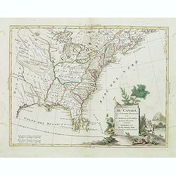
Il Canada Le Colonie Inglesi Con La Luigiana E Florida di nuouva Projezione...1778.
Map of East coast of America including the Great Lakes. The map makes mention of the upper and lower English Colonies in Louisiana. Ohio here called "Ohio ou alta Lu...
Date: Venise, 1778
Selling price: ????
Please login to see price!
Sold in 2015
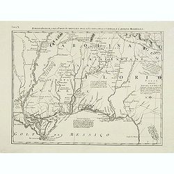
Luigiana Inglese, colla Parte Occidentale della Florida, della Giorgia, e Carolina Meridonale.
Showing the area bounded by the Mississippi River, Gulf Coast and the Southern Appalachians. The map is based on the Mitchell' map and was published in Antonio Zatta's fo...
Date: Venice, 1778
Selling price: ????
Please login to see price!
Sold in 2014
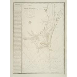
Plan de la Riviere du Cap Fear depuis la Barre jusques a Brunswick?. (Cape Fear)
A well engraved and highly detailed chart that was issued in Neptune Americo-Septentrionale. This chart is based on Sayer & Bennett's chart that was issued in 1776 an...
Date: Paris 1778
Selling price: ????
Please login to see price!
Sold
Carte des troubles De L'Amerique..New-York.. Jersey..
A French edition of this uncommon map giving good detail of the states of New York and New Jersey. Claude Joseph Sauthier was a German surveyor from Strasbourg who immigr...
Date: Paris 1778
Selling price: ????
Please login to see price!
Sold
Carte de la Virginie et du Maryland. .
A third state (of 5), with Groux added to the cartouche. The late eighteenth century mapping of Virginia was dominated by Joshua Fry and Peter Jefferson's "A Map of ...
Date: Paris, 1755 - 1778
Selling price: ????
Please login to see price!
Sold in 2011
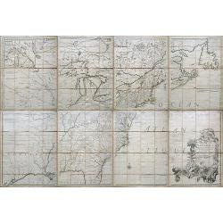
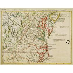
Partie De L'Amerique Septentrionale... Le Cours De L'Ohio, La N.lle Angleterre, a Nlle York, le New Jersey , La Pensyvanie, Le Maryland, Le Virginie, La Carolina...1755
From the Atlas Universel, a detailed map extending the length of the east coast from Penobscot Bay to Cape Fear and, in an inset, from Cape Fear to Fort St.Georges.This s...
Date: Paris, 1755 -1778
Selling price: ????
Please login to see price!
Sold
Partie de l'Amerique septentrionale.. le cours de L'Ohio..
From the Atlas Universel , a detailed map extending the length of the east coast from Penobscot Bay to Cape Fear and, in an inset, from Cape Fear to Fort St.Georges.This ...
Date: Paris (1755) 1778
Selling price: ????
Please login to see price!
Sold
Mexico of Nieuw Spanje.
A map of Mexico and Texas ( called Tecas) from the Dutch edition of Robertson's ' History of America'.
Date: Amsterdam, 1778
Selling price: ????
Please login to see price!
Sold in 2018
Carte du Theatre de la Guerre actuel entre les Anglais et les Trieze Colonies Unies de l'Amerique Septentrionale dresse par J.B. Eliot
A fine example of J. B. Eliot's map of the United States, in its first state - which is generally regarded as the earliest map to include the title "United States&qu...
Date: Paris, 1778
Selling price: ????
Please login to see price!
Sold in 2015

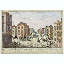
L'entrée triumphale de troupes royales à Nouvelle York.
So-called optical print of New York. Although Washington’s troops successfully retreated to Manhattan after their defeat at the Battle of Long Island, their position wa...
Date: Augsburg, 1778
Selling price: ????
Please login to see price!
Sold in 2012
![[Grand Manan Island (N.B.), Maine, New Brunswick.]](/uploads/cache/36367-250x250.jpg)
[Grand Manan Island (N.B.), Maine, New Brunswick.]
A chart of part Maine and New England taken from the "Atlantic Neptune", and marked in lower right corner "Surveyed & Published according to Act of Par...
Date: London, 1778
Selling price: ????
Please login to see price!
Sold in 2015
La Baja D' HUDSON Terra Di Labrador e Groenlandia con Le Isole Adiacenti.
An excellent, old outlined colored map of Hudson Bay, Baffin Bay, part of Greenland, Labrador and Northern Canada. With marvellous detail on the islands and coastlines, k...
Date: Venice, 1778
Selling price: ????
Please login to see price!
Sold in 2020
![[Kennebec or Sagadehoc River.]](/uploads/cache/36366-250x250.jpg)
[Kennebec or Sagadehoc River.]
A chart of Sagadahoc County taken from the "Atlantic Neptune", and marked in lower right corner "Published according to Act of Parliament April 24, 1776 by...
Date: London, 1778
Selling price: ????
Please login to see price!
Sold in 2016
![[ Moose à Becky's Beach - Maine]](/uploads/cache/36364-250x250.jpg)
[ Moose à Becky's Beach - Maine]
A chart of part of Maine's coast line taken from the "Atlantic Neptune", and marked in lower right corner "Published according to Act of Parliament April 2...
Date: London, 1778
Selling price: ????
Please login to see price!
Sold in 2015
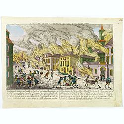
Representation du feu terrible à Nouvelle York.
So-called optical print of New York, showing several buildings along street engulfed in flames during fire on September 19, 1776, citizens being beaten by Redcoats, and l...
Date: Augsburg, 1778
Selling price: ????
Please login to see price!
Sold in 2019
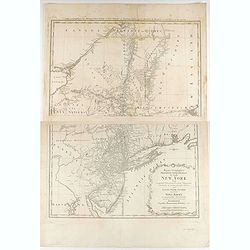
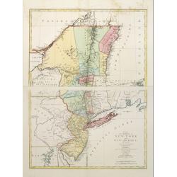
Mappa geographica Provinciæ Nova Eboraci ab Anglis New-York dictæ ex ampliori delineatione ad exactas dimensiones concinnata in arctius spatium redacta cura Claudii Josephi Sauthier ...
Mappa geographica Provinciæ Nova Eboraci ab Anglis New-York dictæ ex ampliori delineatione ad exactas dimensiones concinnata in arctius spatium redacta cura Claudii Jos...
Date: Nuremburg, 1778
Selling price: ????
Please login to see price!
Sold in 2020
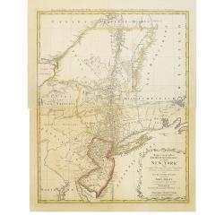
Mappa geographica Provinciæ Nova Eboraci ab Anglis New-York dictæ ex ampliori delineatione ad exactas dimensiones concinnata in arctius spatium redacta cura Claudii Josephi Sauthier cui accedit Nova Jersey ex topographicis observationibus.
Homann Heirs' edition of Sauthier's celebrated map of New York and New Jersey, made during the Revolutionary War. Also shows portions of Pennsylvania and New England. Rel...
Date: Nuremburg, 1778
Selling price: ????
Please login to see price!
Sold in 2018
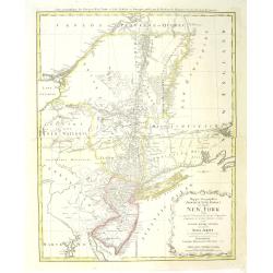
Mappa geographica Provinciæ Nova Eboraci ab Anglis New-York dictæ ex ampliori delineatione ad exactas dimensiones concinnata in arctius spatium redacta cura Claudii Josephi Sauthier cui accedit Nova Jersey ex topographicis observationibus.
Homann Heirs' edition of Sauthier's celebrated map of New York and New Jersey, made during the Revolutionary War. It also shows portions of Pennsylvania and New England. ...
Date: Nuremberg, 1778
Selling price: ????
Please login to see price!
Sold in 2011

Representation du feu terrible à nouvelle york.
So-called optical print of New York, showing several buildings along street engulfed in flames during fire on September 19, 1776, citizens being beaten by Redcoats, and l...
Date: Augsburg, 1778
Selling price: ????
Please login to see price!
Sold in 2011
L\'entrée triumphale de troupes royales à Nouvelle York
So-called optical print of New York. Although Washington’s troops successfully retreated to Manhattan after their defeat at the Battle of Long Island, their position wa...
Date: Augsburg, 1778
Selling price: ????
Please login to see price!
Sold in 2011
Parte Orientale della Florida, della Giorgia, e Carolina Meridionale.
Attractive map covering the coast from S.Augustine till Long Bay, including Jacksonville, Savannah. From Zatta's Atlante Novissimo.
Date: Venice, 1778
Selling price: ????
Please login to see price!
Sold in 2011
Luigiana Inglese, colla Parte Occidentale della Florida, della Giorgia, e Carolina Meridonale.
Showing the area bounded by the Mississippi River, Gulf Coast and the Southern Appalachians. The map is based on the Mitchell' map and was published in Antonio Zatta's fo...
Date: Venice, 1778
Selling price: ????
Please login to see price!
Sold in 2011
