Browse Listings in America > North America > Alaska
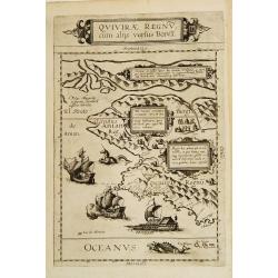
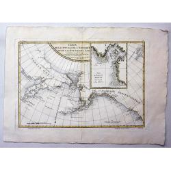
Quivirae Regnv cum alijs versus Borea.
Extraordinarily rare map, the first published map devoted to the west and north-west coasts of North America.The map not only conveys the early cartographic view of the N...
Date: Antwerp 1593
Selling price: ????
Please login to see price!
Sold
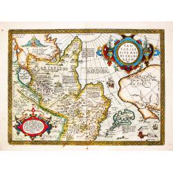
Tartariae sive Magni Chami Regni Typus.
Tartariae sive Magni Chami Regni Typus. Map of Mongolia, also showing the northwest coast of North America. Abraham Ortelius(1527-98), Dutch cartographer and publishe...
Date: Antwerp, Robert Bruneau, 1609
Selling price: ????
Please login to see price!
Sold in 2021
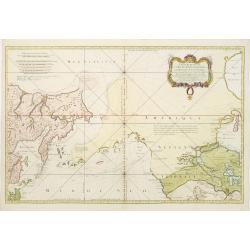
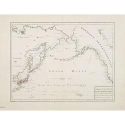
Carte Réduite de L'Ocean Septentrional. . .
A first state, with no page number, price or Depot de la Marine stamp engraved anywhere. Large and detailed map prepared by Bellin of east coast of Asia and western Ameri...
Date: Paris 1766
Selling price: ????
Please login to see price!
Sold
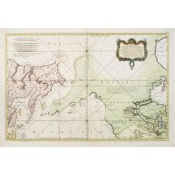
Carte Réduite de L'Ocean Septentrional compris entre l'Asie et l'Amerique.. (1766)
Large and detailed chart prepared by N.Bellin of east coast of Asia and western America, including Alaska, California, and Great Lakes region in the typical Bellin format...
Date: Paris 1766
Selling price: ????
Please login to see price!
Sold
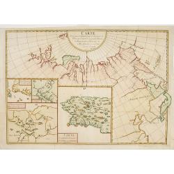
Carte de la partie Septentrionale et Orientale .. (5 maps on one sheet)
Five maps on one sheet, showing California, Alaska and Siberia and Japan.Map I showing Alaska, California as a peninsular, eastern tip of Japan with a curious Islade Plat...
Date: Paris, 1772
Selling price: ????
Please login to see price!
Sold in 2023
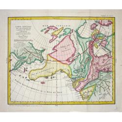
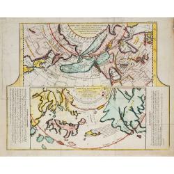
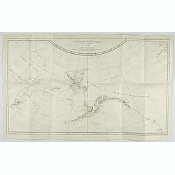
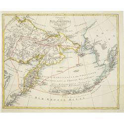
Carte Generale des Decouvertes de l' Amiral de Fonte representant la grande probabilite d'un Passage au Nord Ouest
The probably most extravagant of all the Northwest Passage maps after Thomas Jefferys, a passionate believer in the northern route to Asia and prepared this map to show t...
Date: Paris, 1772
Selling price: ????
Please login to see price!
Sold
CARTE GENERALE DES DECOUVERTES de l'Amiral de Fonte,representant la grande possibilite d'un PASSAGE AU NORD OUEST.
A fascinating map of the Northwestern part of America, illustrating the reports of De L'Isle of the Russian discoveries in the region prior to 1750, which he obtained dur...
Date: Paris, 1772
Selling price: ????
Please login to see price!
Sold in 2019
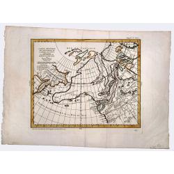
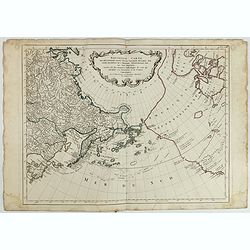
Nouveau Systeme Geographique par lequel on concilie les anciennes connoissances sur les Pays Nord-Ouest de l'Amerique avec les nouvelles decouvertes des Russes au Nord de la Mer du Sud.
An extremely rare and virtually unknown Dutch edition of De Vaugondy's map, published in Amsterdam by Krevelt in 1777. De Vaugondy's Final Chapter In The Greatest Cartogr...
Date: Amsterdam, 1777
Selling price: ????
Please login to see price!
Sold in 2018
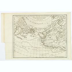
Carte des Nouvelles découvertes ?
The map is from Diderot's 'Encyclopedia' which contains ten maps of Asia, America and the Arctic Regions. In both maps there are texts ago. by Kaempfer who refers to voya...
Date: Paris, 1779
Selling price: ????
Please login to see price!
Sold in 2009
Carte de la côte N. O. de l\'Amérique et de la côte N. E. de l\'Asie reconnues en 1778 et 1779..
Map of the north Pacific with Alaska, engraved by Bernard.
Date: Paris, c. 1779
Selling price: ????
Please login to see price!
Sold in 2013
![Carte Des Nouvelles Decouvertes dresseee par Phil. Buache... [with] Extrait d'une Carte Japonoise de l'Univers apportee en Europe par Kaempfer . . . [Bay of the West]](/uploads/cache/25609-250x250.jpg)
Carte Des Nouvelles Decouvertes dresseee par Phil. Buache... [with] Extrait d'une Carte Japonoise de l'Univers apportee en Europe par Kaempfer . . . [Bay of the West]
This map is most notable for it's depiction of "Mer de L'Ouest" or "Sea of the West", a great sea, easily the size of the Mediterranean, to flow from ...
Date: Paris, 1779
Selling price: ????
Please login to see price!
Sold in 2014
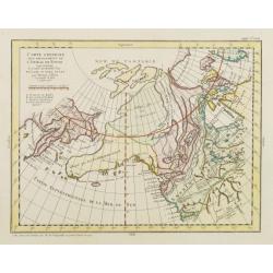
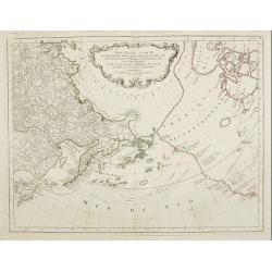
Carte Générale des Découvertes de l'Amiral de Fonte representant la grande probabilité d'un Passage au Nord Ouest. . .
Robert de Vaugondy based this map of the northern Pacific and Alaska on a publication by Thomas Jefferys in London in 1768. Published in the supplement to Diderot’s &qu...
Date: Paris, 1779
Selling price: ????
Please login to see price!
Sold in 2013
![Carte de la côte N[ord] O[uest]. de l'Amérique et de la côte N. E. de l'Asie reconnues en 1778 et 1779. . .](/uploads/cache/43766-250x250.jpg)
Carte de la côte N[ord] O[uest]. de l'Amérique et de la côte N. E. de l'Asie reconnues en 1778 et 1779. . .
A map of the north Pacific with Alaska, engraved by André. With inset map "Plan de l'Entrée de Nootka. . ." This is the general map of the northwest coast fro...
Date: Paris, ca 1780
Selling price: ????
Please login to see price!
Sold in 2020
Carte der Entdekungen Zwischen Sibirien und America bis auf das Jahr 1780
Very unusual map of Alaska and Kamchatka. Alaska is shown with only coastal detail according the reports of Capt. Cook. The Aleutian Islands stretch to within sight of th...
Date: Germany c.1781
Selling price: ????
Please login to see price!
Sold
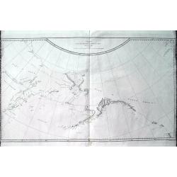
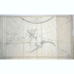
Chart of the N.W. Coast of America and N.E. Coast of Asia explored in the Years 1778 & 1779. . .
A scarce edition of Captain James Cook's discoveries in the Pacific Northwest, Alaska, and the Behring Strait. The map shows the northeast parts of Asia and the northwest...
Date: London, ca 1784
Selling price: ????
Please login to see price!
Sold in 2019
Nouvelle carte des decouvertes faites. . .
Santini's version of Gerhard Muller's landmark map of 1754 showing the discoveries of Captains Bering and Tschirikow.Muller originally published his map in response to Jo...
Date: Venice, 1784
Selling price: ????
Please login to see price!
Sold in 2015
Nouvelle Carte des Decouvertes Faites par des Vaisseaux Russes aux Cotes Inconnues del' Amerique Septentrionale avec les Pais Adiancents..
Santini's version of Gerhard Muller's landmark map of 1754 showing the discoveries of Captains Bering and Tschirikow.Muller originally published his map in response to Jo...
Date: Venice, 1784
Selling price: ????
Please login to see price!
Sold in 2011
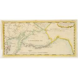
Carte de la Cote N.O. de l'Amerique et de la Cote N.E. de l'Asie, Reconnues en 1778 et 1779. Les parties de la Cote d'Asie qui ne sont pas ombrees sont tirees d'une Carte Manuscrite que nous donnerent les Russes.
Map of the North Pacific and contiguous coastlines of Alaska and Russia, published in the first French edition of the official account of James Cook's Third Voyage. The ...
Date: Paris, 1785
Selling price: ????
Please login to see price!
Sold in 2022
Carte de la Cote N.O. de L'Amerique et de la Cote N.E. de l' Asie.
Map of the north Pacific with Alaska, engraved by André. This is the general map of the Northwest Coast from the atlas volume of the first French edition of Cook's third...
Date: Paris, 1785
Selling price: ????
Please login to see price!
Sold in 2021
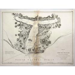
Plan of Port des Francais on the North West Coast of America in 58° 37' Latitude North and 139° 50 of Longitude West Discovered in July, 1786. . .
A fine copperplate chart of the 'Port des Francais' in Alaska. After reaching the northwest coast of America, at the height of Mount Saint-Elie, after one year of navigat...
Date: Paris, 1786
Selling price: ????
Please login to see price!
Sold in 2018
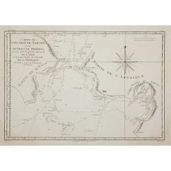
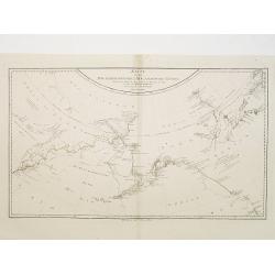
Carte de L'Entrée de Norton et du Détroit de Bhering, ...
The Bering Straits and Norton Sound, Alaska, showing the two attempts of Captain Cook's ship to penetrate the Straits on his third & final, fatal, voyage in 1778-79.
Date: Paris, 1787
Selling price: ????
Please login to see price!
Sold in 2011
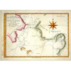
Carte de L'Entre de norton et du Detroit de Bhering.
Fine detailed map of the Behring Strait, the passage between Russia and Alaska. Includes the track of the voyage of Captain James Cook. Engraved and signed in engraving b...
Date: Paris, 1787
Selling price: ????
Please login to see price!
Sold in 2015
![[2 sheets] Carte de la Cote N.O. de l'Amerique et de la cote N.E. de l' Asie. / Carte de L'Entree de Norton et du Detroit de Bhering. . .](/uploads/cache/83615-250x250.jpg)
[2 sheets] Carte de la Cote N.O. de l'Amerique et de la cote N.E. de l' Asie. / Carte de L'Entree de Norton et du Detroit de Bhering. . .
A set of maps of the north Pacific with Alaska, engraved by André. They are after the general map of the Northwest Coast from the atlas volume of the first French editio...
Date: Paris, 1785-1787
Selling price: ????
Please login to see price!
Sold in 2020
Karte von den N.W.Amerikanische und N.O.E. Asia..
German edition of Cook's explorations along the NW Coast of America and NE Coast of Asia, based upon the original work by Lieutenant Henry Roberts.A detailed large-scale ...
Date: Vienna 1788
Selling price: ????
Please login to see price!
Sold in 2008
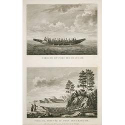
Pirogue du port des français. / Pirogue, trouvée au port des français.
From Atlas du Voyage de la Pérouse.Lituya Bay is a fjord located on the coast of the Southeast part of the U.S. state of Alaska. The bay was noted in 1786 by Jean-Franç...
Date: Paris, 1788
Selling price: ????
Please login to see price!
Sold in 2010
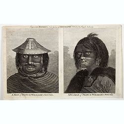
A Man of Prince William's Sound / A Woman of Prince William's Sound.
A pair of copperplate engravings of a man and a woman from Prince William's Sound in Gulf of Alaska - taken rom drawings by John Webber from John Hawkesworth's account of...
Date: London, ca 1790
Selling price: ????
Please login to see price!
Sold in 2023
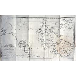
A Chart of the Interior part of North America demonstrating the very great possibility of an Island of Navigation from Hudson's Bay to the West Coast
Rare and curious map of a supposed "Northwest Passage" from the Hudson Bay into the Pacific Ocean. Based upon the explorations of John Meares in 1788 and 1789....
Date: London, 1790
Selling price: ????
Please login to see price!
Sold in 2009
![[No title] Kamtschatskisches Meer.](/uploads/cache/21312-250x250.jpg)
[No title] Kamtschatskisches Meer.
Engraved by S. V.Dorn. Early map of Alaska.
Date: Germany 1790
Selling price: ????
Please login to see price!
Sold
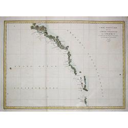
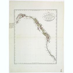
Carte particulaiere de la Côte du Nord-Ouest de l\'Amerique, 1e Feuille.
Jean François Galoup, Comte de la Pérouse (1741-88), outstanding French explorer and hydrographer. Voyage autour du Monde?Atlas', 1797.A large chart from La Pérouse's ...
Date: Paris, 1797
Selling price: ????
Please login to see price!
Sold in 2009
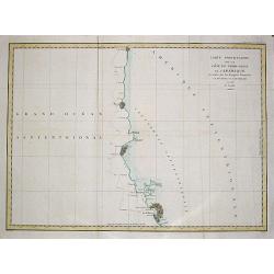
Carte particulaire de la Côte du Nord-Ouest de l\'Amerique, 3e Feuille.
Jean François Galoup, Comte de la Pérouse (1741-88), outstanding French explorer and hydrographer. Voyage autour du Monde?Atlas', 1797.A large chart from La Pérouse's ...
Date: Paris, 1797
Selling price: ????
Please login to see price!
Sold in 2009
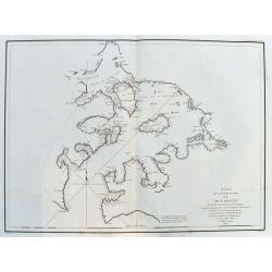
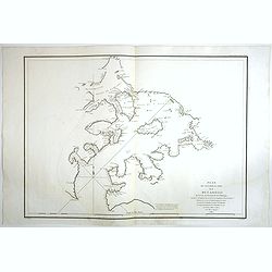
Plan de l'Entree du Port de Bucarelli sur la Cote du Nord-Ouest de l'Amérique. . .
A large chart of Bucareli Bay which is part of the Alexander Archipelago in the southeastern portion of Alaska. Highly detailed with coasts, islands, small rocks, and dep...
Date: Paris, ca.1797
Selling price: ????
Please login to see price!
Sold in 2020
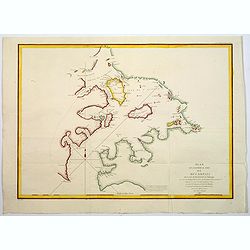
Plan de l'Entrée du Port de Bucarelli sur la cote du Nord-Ouest de l'Amerique.
The Port Bucarelli is a harbour in Alaska, discovered in 1775 by two Spaniards, La Quadra & Maurelle, at Latitude 55N the furthest north that Spanish explorers got.Th...
Date: Paris, 1797
Selling price: ????
Please login to see price!
Sold in 2017
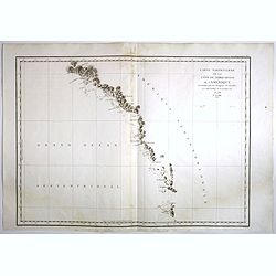
Carte Particuliere de la Cote du Nord-Ouest de l'Amerique reconnue par les Fregates Francaises la Boussole et l' Astrolabe en 1786 1e. Feuille.
Attractive chart of the Alaskan coast from Mount St.Elie south to Bay de ClonardThis chart was engraved by Bouclet for La Pérouse's 'Voyage autour du Monde'.Jean Francoi...
Date: Paris, 1797
Selling price: ????
Please login to see price!
Sold in 2018
Plan de l'Entree du Port de Bucarelli sur la Cote du Nord-Ouest de l'Amerique, par 55°15' de Latitude Nord et 136°15' de Longitude a l'Ouest de Paris . . .
Attractive chart of Bucareli Bay which is part of the Alexander Achipelago in the southeastern portion of AlaskaThis chart was engraved by Bouclet for La Pérouse's 'Voya...
Date: Paris, 1797
Selling price: ????
Please login to see price!
Sold in 2018
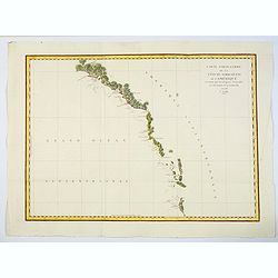
Carte Particuliere de la Cote du Nord-Ouest de l'Amerique reconnue par les Fregates Francaises la Boussole et l' Astrolabe en 1786 1e. Feuille.
An attractive chart of the Alaskan coast from Mount St. Elie, south to Bay de Clonard.This chart was engraved by Bouclet for La Pérouse's 'Voyage autour du Monde'.Jean F...
Date: Paris, 1797
Selling price: ????
Please login to see price!
Sold in 2020
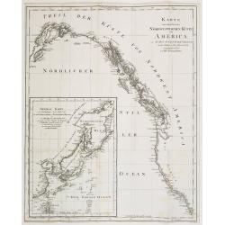
Karte von einem theil der Nord westlichen Küste von America..
A very nice map centered on Northwest coast of America, including the city of Vancouver. On the lower left corner, an inset map (285x208 cm) of Japan, Taiwan and Chinese ...
Date: Berlin 1800
Selling price: ????
Please login to see price!
Sold
Charte von dem Meer von Kamtschatka mit Capt. Jos. Billings und Mart. Sauers Reise Routen..
Uncommon map of the west coast of America showing the tracks of Billings and Sauers.Prepared by Ferd Götze.
Date: Weimar 1804
Selling price: ????
Please login to see price!
Sold
Carte de la partie de la cote nord-ouest de l'Amerique. Reconnue pendant les Etes de 1792, 1793 et 1794 depuis 29054' de latitude nord et 244033' de. . .
Detailed and rare map of the Gulf of Alaska, British Columbia, south to St.Francisco.Prepared by Edward Roberts after information by George Vancouver. Engraved by Tardieu...
Date: Paris, 1820
Selling price: ????
Please login to see price!
Sold in 2011
Partie septentrionale de l'Océan Pacifique ou l'on marqué les découvertes et les routes de M.rs de la Pérouse et Cook.
Detailed and rare map of the northern part of the Pacific with the Gulf of Alaska, British Columbia, south to St.Francisco and the east coast of Asia from Tartary to Kore...
Date: Paris, 1820
Selling price: ????
Please login to see price!
Sold in 2011
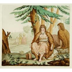
Femme du Port des Français.
From Giulio Ferrario's work Le Costume ancien et moderne ou histoire du gouvernement, de la milice, de la religion, des arts, etc. published in Milan by the author betwee...
Date: Milan 1827
Selling price: ????
Please login to see price!
Sold
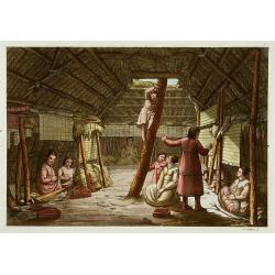
Intérieur d'une maison d'Unalaschka.
This aquatint engraved plate was color printed on fine move paper of a soft aged white color, bearing the embossed seal of authenticity impressed at the time of publicati...
Date: Milan 1827
Selling price: ????
Please login to see price!
Sold

Extérieur d'une maison Aleut.
Aquatint showing the outside of an Aleut house such as it was depicted by Cook during its journey.From Giulio Ferrario's work Le Costume ancien et moderne ou histoire du ...
Date: Milan, 1827
Selling price: ????
Please login to see price!
Sold
![[ Habitants d'mérique du Nord-Ouest. ]](/uploads/cache/15587-250x250.jpg)
[ Habitants d'mérique du Nord-Ouest. ]
Aquatint depicting the way of closing of the Aleuts, north/west America inhabitants. The man is shown with his nose and lower lip pierced with bones. The woman is also pi...
Date: Milan, 1827
Selling price: ????
Please login to see price!
Sold in 2012
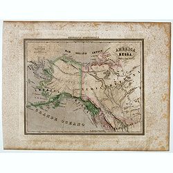
America Russa.
Uncommon map of Alaska prepared by Francesco Costantino Marmocchi. Above the map "Geografia Commerciale". From "Il Globo Atlante di carte Geografiche compi...
Date: Genova, Paolo Rivara fu Giacomo, 1858
Selling price: ????
Please login to see price!
Sold in 2020
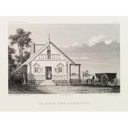
Isba, Maison des colonies de l'Amérique Russe.
Early print of a colonial house in Alaska. Engraved by Ch.Ransonette and published by Arthus Bertrand. From: Voyage de M.D. de Mofras .Duflot de Mofras, an attaché of th...
Date: Paris, 1860
Selling price: ????
Please login to see price!
Sold in 2012
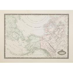
Amérique Russe et partie de regions polaires boeales.
Very detailed map from Atlas Sphéroïdal & Universel de géographie , Prepared by F.A.Garnier and edited by Jules Renouard, rue de Tournon, Paris. Uncommon with deco...
Date: Paris, 1861
Selling price: ????
Please login to see price!
Sold in 2012
![[Tittle in Russian] Kapta. . . (Russian Alaska).](/uploads/cache/29139-250x250.jpg)
[Tittle in Russian] Kapta. . . (Russian Alaska).
Chart of Russian Alaska showing cap Prince of Wales. In two sheets joined as one. Text written in Russian. This detailed large scale chart centers on the extreme north ea...
Date: Moscow, 1874
Selling price: ????
Please login to see price!
Sold in 2014
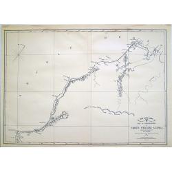
War Department Map of Exploration of North Western Alaska...
Unusual survey map of the Arctic Ocean and Northwestern Alaska.
Date: 1902
Selling price: ????
Please login to see price!
Sold in 2010
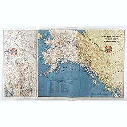
Map of Alaska, YukonTerritory and British Columbia showing connections of The White Pass & Yukon Route.
Railway map of Alaska, YukonTerritory and British Columbia showing connections of The White Pass & Yukon Route. On the back informations about the trip.
Date: Chicago, 1904
Selling price: ????
Please login to see price!
Sold in 2021
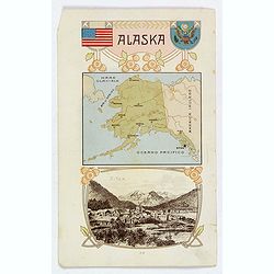
Alaska / Costume del S. Salvador.
An unusual item. It is a nice colored chromolithograph map of Alaska, with a few place names, a coat of arms and the American flag, together with a small view of Sitca be...
Date: Milano, 1905
Selling price: ????
Please login to see price!
Sold in 2019
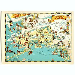
Alaska.
Pictorial map of Alaska, from the famous illustrator, Ruth Taylor White and published in "Our USA: A Gay Geography".Ruth Taylor White was among the most prolifi...
Date: Boston, Little, Brown and Company, 1935
Selling price: ????
Please login to see price!
Sold in 2018
