Browse Listings in America > North America > Mississippi / Louisiana / Illinois / Missouri
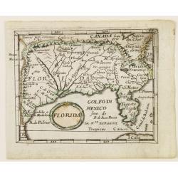
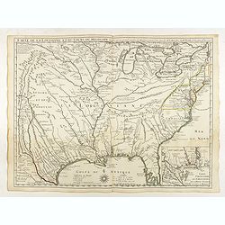
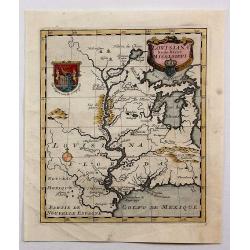
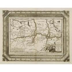
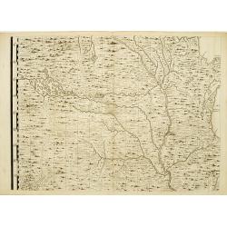
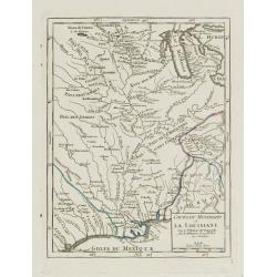
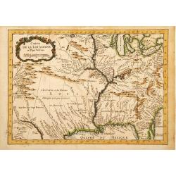
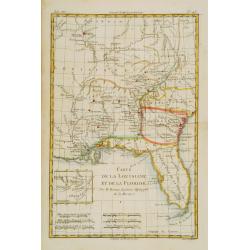
Florida.
Uncommon derivate of this miniature map of Louisiana and Florida. Similar to the map in Pierre Duval's La Geographie Universeille, which was derived from La Floride , 165...
Date: Nuremberg 1678
Selling price: ????
Please login to see price!
Sold
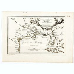
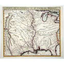
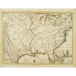
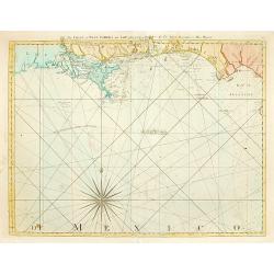
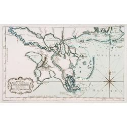
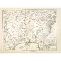
Les Costes aux Environs de la Riviere de Misisipi.
An historically important map of Florida and the Gulf Coast showing especially the estuary of the Mississippi in some detail, more or less correctly located.The locations...
Date: Paris, 1701
Selling price: ????
Please login to see price!
Sold in 2022
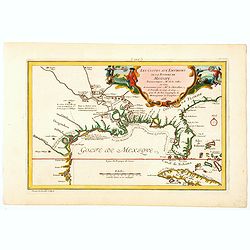
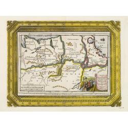
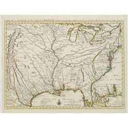
Les Costes aux Environs de la Riviere de Misisipi.
An historically important map of Florida and the Gulf Coast circa 1700 showing especially the estuary of the Mississippi in some detail, more or less correctly located.Th...
Date: Paris, 1705
Selling price: ????
Please login to see price!
Sold in 2021
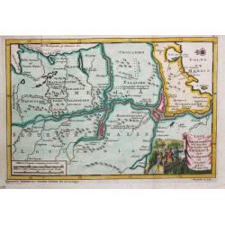
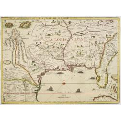
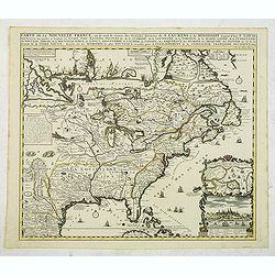
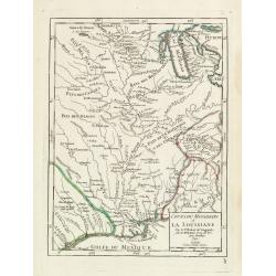
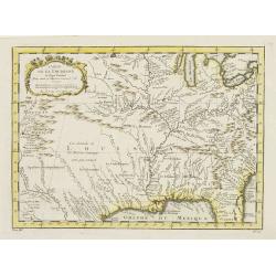
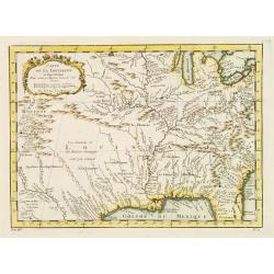
Land en Volk-ontdekkingen in' t Noorder gedeelte van America door P. Marquette en Joliet gedaan in' t Jaar 1673.
An important map of the Mississippi river area, illustrating the voyage of Marquette and Joliet made in 1673. Embellished with a large and decorative title-cartouche, sho...
Date: Leiden, 1707
Selling price: ????
Please login to see price!
Sold in 2021
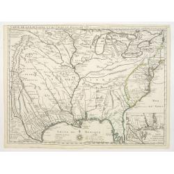
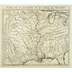
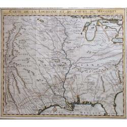
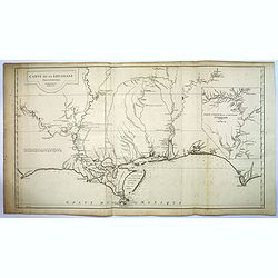
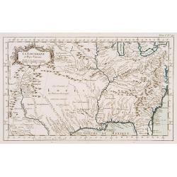
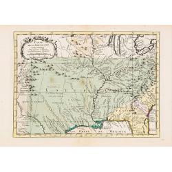
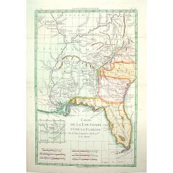
Carte de la Louisiane et du cours du Mississipi.
First issue, first state (New Orleans not yet located) of “the first detailed map of the Gulf region and the Mississippi, [and] the first printed map to show Texas”(T...
Date: Paris 1718
Selling price: ????
Please login to see price!
Sold
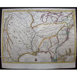
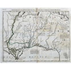
Partie Meridionale de La Riviere de Missisipi..
The printed version of the most important map of the Mississippi Valley and Gulf of Mexico, prepared in manuscript by De L'Isle (Carte des Environs du Mississippi, 1701) ...
Date: Paris, 1718
Selling price: ????
Please login to see price!
Sold in 2013
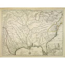
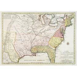
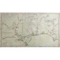
Carte de la Louisiane et du cours du Mississipi.
First issue, second state. First map to name New Orleans. This map is known for its detailed depiction of the states adjacent to the Gulf of Mexico region and the Mississ...
Date: Paris, 1718
Selling price: ????
Please login to see price!
Sold in 2008
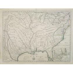
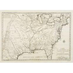
Carte de la Louisiane et du cours du Mississipi.
First issue, first state. New Orleans not yet listed!. This map is known for its detailed depiction of the states adjacent to the Gulf of Mexico region and the Mississipp...
Date: Paris, 1718
Selling price: ????
Please login to see price!
Sold
Carte de la Louisiane et du cours du Mississipi.
First issue, first state. New Orleans not yet listed!. This map is known for its detailed depiction of the states adjacent to the Gulf of Mexico region and the Mississipp...
Date: Paris, Juin 1718
Selling price: ????
Please login to see price!
Sold in 2018
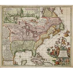
Carte de la Nouvelle Franc où se voit le cours des Grandes Rivières de St Laurens et de Mississipi Aujourd'hui St Louis . . .
Derived from de Fer's 1718 map, from west of the Mississippi it contains a mass of inland detail with notes and vignettes of the indigenous peoples and fauna of North Ame...
Date: Amsterdam, 1719
Selling price: ????
Please login to see price!
Sold in 2012

Koning en Koningin van de Mississippi.
An Indian couple of the Mississippi area. From a book satirizing the disastrous Mississippi scheme (1718-1720) of the French Compagnie d'Occident and the speculation of i...
Date: Amsterdam, 1720
Selling price: ????
Please login to see price!
Sold in 2013

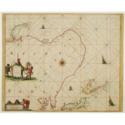
Pasquins windkaart op de windnegotie van 't Iaar 1720
Pasquin's wind card on the wind trade of the year 1720. Set of 52 illustrated playing-cards with human figures and a little explanation under each one. Interesting is the...
Date: Amsterdam 1720
Selling price: ????
Please login to see price!
Sold

De inbeelding heersseres van't rookverkopers-gild, maald Mississippi hier 't geen Vrankryks schat verspild.
Decorative print published in : Het groote tafereel der dwaasheid : vertoonende de opkomst, voortgang en ondergang der actie, bubbel en windnegotie, in Vrankryk, Engeland...
Date: Amsterdam, 1720
Selling price: ????
Please login to see price!
Sold in 2010
Carte de la Louisiane et du Cours du Mississipi Dressée sur un grand nombre de Memoires.
Anonymous map copied from the important de L'Isle map. The map shows "Natichitoches, éstablissemt. François fait en 1717 par Mr. De Bienville" and routes of e...
Date: Paris, c. 1720
Selling price: ????
Please login to see price!
Sold in 2012
Louisiana by de Rivier Mississippi.
Scarce map of the Mississippi River Valley and Great Lakes regions. The map is primarily based on Hennepin with enlarged Great Lakes and the Mississippi located too far w...
Date: Amsterdam, ca. 1720
Selling price: ????
Please login to see price!
Sold in 2016
Lousiana by de Rivier Missisisppi.
A scarce little map of the Mississippi River Valley and western Great Lakes from the book “Het Groote Tafereel der Dwaasheid…” which accounts for the history of Joh...
Date: Amsterdam, 1720
Selling price: ????
Please login to see price!
Sold in 2019

Afbeeldinge van't zeer vermaarde Eiland Geks-Kop. . .
The central map of the island of Madhead is contained in an elaborately engraved cartouche surrounded by scenes of ill-fated investors storming the offices of John Law's ...
Date: Amsterdam, 1720
Selling price: ????
Please login to see price!
Sold in 2019
CARTE DE LA LOUISIANE ET DU COURS DU MISSISSIPI.
A nice example of Jean Frederic Bernard's rare variant edition of Guillaume De L'Isle's seminal map, one of the most important and influential maps of the 18th Century, w...
Date: Amsterdam, 1720
Selling price: ????
Please login to see price!
Sold in 2019
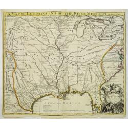
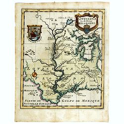
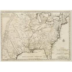
A map of Louisiana and of the Mississipi.
A scarce first English version of the influential map published by Guillaume De L'Isle in 1718.The original was a landmark map in the cartography of the region, centered ...
Date: London, 1721
Selling price: ????
Please login to see price!
Sold

Pasquins Windkaart op de Windnegotie van 't Iaar 1720.
Undivided engraved sheet of 54 pictorial playing cards. Engraving on mounted paper.This is an early 18th-century uncut playing card sheet based on the disastrous collapse...
Date: Amsterdam, 1721
Selling price: ????
Please login to see price!
Sold in 2013
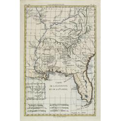
La Floride suivant les nouvelles observations...
Uncommon edition of this map of Florida. From Le Nouveau Theatre du Monde, ou la Geographie Royale.
Date: Amsterdam, 1728
Selling price: ????
Please login to see price!
Sold in 2020
Land en volk-ondekking in't noorder gedeelte van America door P.Marquette en Joliet.
Interesting map of the Mississippi delta. East to the top. According to the title the information is after P.Marquette and Joliet.This example is unusual in having the ad...
Date: Amsterdam 1729
Selling price: ????
Please login to see price!
Sold
Carte de la Louisiane et du cours du Mississipi.
Shows Indian villages, "nations derangees, nations detruites," the route of de Soto, Moscoso, Cavelier, Tonty and Denis, etc. Relief shown pictorially. Covers a...
Date: Amsterdam, 1730
Selling price: ????
Please login to see price!
Sold in 2014
Carte de la Louisiane et du Cours du Mississipi.
Carte de la Louisiane et du Cours du Mississipi." From Jean Frederic Bernard's Recueil de Voiages au Nord. Amsterdam: J.F. Bernard, 1734.This is a reduced-size editi...
Date: Paris, 1734
Selling price: ????
Please login to see price!
Sold in 2016
Sheet 5 of 20: The Mississippi River system and its tributaries.
One sheet of H.Popple's twenty-sheet survey of North America, in a first stae, the first large-scale map of the British colonies in America. Featuring the Great Lakes in ...
Date: London 1733-1735
Selling price: ????
Please login to see price!
Sold
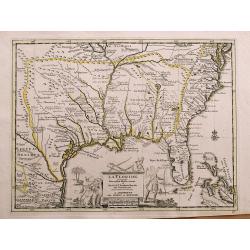
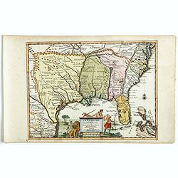
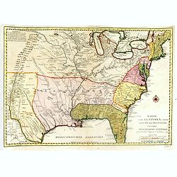
La Floride, suivant les Nouvelles Observations...
Fantastic map based on Delisle's important map of the southern United States of America, stretching from what is now Texas to Florida, and as far north as Tennessee and V...
Date: Amsterdam, 1735
Selling price: ????
Please login to see price!
Sold in 2014
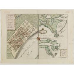
![Grondvlakte van Nieuw Orleans, de Hoofdstad van Louisiana [with] De Uitloop vande Rivier Missisippi [and] De Oostelyke ingang van de Missisippi met een Plan van het Fort .](/uploads/cache/39133-250x250.jpg)
Grondvlakte van Nieuw Orleans, de Hoofdstad van Louisiana [with] De Uitloop vande Rivier Missisippi [and] De Oostelyke ingang van de Missisippi met een Plan van het Fort .
A sought after, highly attractive, decorative sheet that shows three maps arranged around a large compass rose. This work represents Tirion's version of a map that was fi...
Date: Amsterdam, 1740
Selling price: ????
Please login to see price!
Sold in 2017
Karte von Luisiana, dem Laufe des Mississipi und den benachb
A rare German text edition of de l'Isles map of the Gulf region of the Mississippi. The European colonies and possessions along the Atlantic and Gulf coasts share importa...
Date: Paris 1744
Selling price: ????
Please login to see price!
Sold
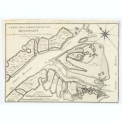
Carte des Embouchures du Mississipi.
This is a lovely chart of the mouth of the mighty Mississippi River, and her delta, as it empties into the Gulf of Mexico, about 75 miles south east of New Orleans. The c...
Date: Paris, ca 1744
Selling price: ????
Please login to see price!
Sold in 2020
Carte de la Louisiane et du Cours du Mississipi Dressée sur un grand nombre de Memoires..
Covens & Mortier's issue of Delisle's influential map of the French possession of Louisiana. Updated to include New Orleans. When originally published in 1718, it was...
Date: Amsterdam c. 1745
Selling price: ????
Please login to see price!
Sold
Carte de la Louisiane et du Cours du Mississipi Dressée sur un grand nombre de Memoires..
Covens & Mortier's issue of Delisle's influential map of the French possession of Louisiana. Updated to include New Orleans.When originally published in 1718, it was ...
Date: Amsterdam c. 1745
Selling price: ????
Please login to see price!
Sold

Carte de la Louisiane et du cours du Mississipi . . .
Covens & Mortier's issue of Delisle's influential map of the French possession of Louisiana. Updated to include New Orleans.When originally published in 1718, it was ...
Date: Amsterdam, 1745
Selling price: ????
Please login to see price!
Sold in 2020
Karte von Luisiana, dem Laufe des Mississipi und den Benachbarten Laendern.
A rare German text edition of de l\'Isle\'s map of North America, focusing on the Mississippi and covering all the known United States, from the Rio del Norte (extending ...
Date: Leipzig, Arkstee & Merkus, 1746
Selling price: ????
Please login to see price!
Sold in 2008
Karte von Luisiana, dem Laufe des Mississipi und den Benachbarten Laendern.
A rare German text edition of de l'Isle's map of North America, focusing on the Mississippi and covering all the known United States, from the Rio del Norte (extending no...
Date: Leipzig, Arkstee & Merkus, 1746
Selling price: ????
Please login to see price!
Sold in 2015
Karte von Luisiana, dem Laufe des Mississipi und den Benachbarten Laendern.
A rare German text edition of de l'Isle's map of North America, focusing on the Mississippi and covering all the known United States, from the Rio del Norte (extending no...
Date: Leipzig, Arkstee & Merkus, 1746
Selling price: ????
Please login to see price!
Sold in 2019
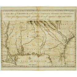
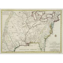
A New Map of Georgia with Part of Carolina, Florida and Loisiana..
Scarce and important early map of colonial Georgia. The map covers from Charles Town to the Mississippi River and extends into Florida to C. Canaveral. The coastal settle...
Date: London c.1748
Selling price: ????
Please login to see price!
Sold
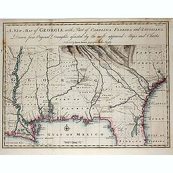
A New Map of Georgia with Part of Carolina, Florida and Loisiana. . .
Scarce and important early map of colonial Georgia. The map covers from Charles Town to the Mississippi River and extends into Florida to C. Canaveral. The coastal settle...
Date: London c.1748
Selling price: ????
Please login to see price!
Sold in 2014
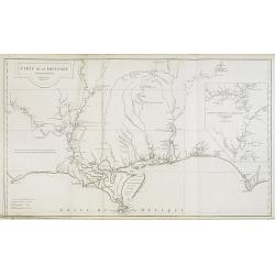
Cours du Mississipi et La Louisiane. . .
Fine map depicting Mississippi delta and Great Lakes in upper right hand corner, from Atlas Portatif, Universel Et Militaire , first published in 1749.Map dated 1749.
Date: Paris, 1749
Selling price: ????
Please login to see price!
Sold in 2021
Cours du Mississipi et la Louisiane.
Nice small map showing the course of the Mississippi River, from Minnesota to the Gulf of Mexico.Number 92 outside border top right. Mary Sponberg Pedley does not mention...
Date: Paris, later than 1749
Selling price: ????
Please login to see price!
Sold in 2022
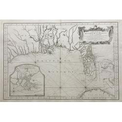
Accurata delineatio Regionis Ludovicianae.
Map of the eastern part of North America focusing on the Mississippi River and the Graet Lakes. Copper engraving with original wash color by M. Rhein, published by Matth�...
Date: Augsburg, c. 1745/1750
Selling price: ????
Please login to see price!
Sold
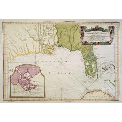
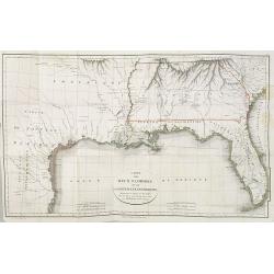
The Coast of West Florida and Louisiana..
Rare and important chart of Louisiana. Jeffery's was one of the most prolific and important English map publishers of the 18th century. His earliest known work was a plan...
Date: London 1752
Selling price: ????
Please login to see price!
Sold
Carte de la Louisiane.
This map provides an accurate rendition of the lower Mississippi, the Arkansas, the Red, the Osage, and the lower Missouri rivers. Thomas Jefferson bought seven maps by A...
Date: Paris, 1752
Selling price: ????
Please login to see price!
Sold in 2009
Carte de la Louisiane. . .
This map provides an accurate rendition of the lower Mississippi, the Arkansas, the Red, the Osage, and the lower Missouri rivers. Thomas Jefferson bought seven maps by A...
Date: Paris, 1752
Selling price: ????
Please login to see price!
Sold in 2016
Carte de la Louisiane.
This map provides an accurate rendition of the lower Mississippi, the Arkansas, the Red, the Osage, and the lower Missouri rivers. Thomas Jefferson bought seven maps by d...
Date: Paris, 1752
Selling price: ????
Please login to see price!
Sold in 2020

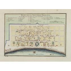
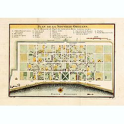
Grundriss von Neu-Orleans. . . N°18.
An important plan of New Orleans. In: Allgemeine Historie der Reisen zur Wasser und zu Lande: oder Sammlung aller Reisebeschreibungen.. in Englischen zusammen getragen, u...
Date: Leipzig, 1753
Selling price: ????
Please login to see price!
Sold in 2008
Carte de la Louisiane et pays Voisins.
Accurate map showing the lower Mississippi River and surrounding areas, the ranges and villages of numerous Indian tribes are shown.Jacques Nicolas Bellin (1703-1772) was...
Date: Paris, 1757
Selling price: ????
Please login to see price!
Sold in 2011
Carte de la Louisiane et pays Voisins.
Accurate map showing the lower Mississippi River and surrounding areas, the ranges and villages of numerous Indian tribes are shown.Jacques Nicolaas Bellin (1703-1772) wa...
Date: Paris 1757
Selling price: ????
Please login to see price!
Sold
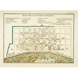
Plan de la Nouvelle Orleans. . .
An important transitional and very detailed early map of New Orleans, copied after the original manuscript town-plan of the city drafted by Le Blond de la Tour in 1722. I...
Date: Paris, 1757
Selling price: ????
Please login to see price!
Sold in 2009
Karte von Luisiana, dem Laufe des Mississipi und den benachbarten Laendern. . .
A scarce German text edition of de l'Isles map, covering all the known United States, from the Rio del Norte (extending north almost to the Missouri headwaters) to the Gr...
Date: Leipzig, 1744 - 1758
Selling price: ????
Please login to see price!
Sold in 2011
Cours du Fleuve Saint Louis..
The mouth of the River Mississippi, depths shown by soundings. The only issue of this version of Bellin's map, slightly larger than the standard version. From Bellin's Pe...
Date: Paris 1764
Selling price: ????
Please login to see price!
Sold
La Louisiane et Pays voisins.
The only issue of this version of Bellin's map, slightly larger than the common version. Excellent detail in the Santa Fe area. More than a dozen rivers, many with names ...
Date: Paris 1764
Selling price: ????
Please login to see price!
Sold
Carte de la Louisiane et Pays Voisins.
A very rare map of Louisiana, Texas and central north America, from Le Commerce de l'Amérique par Marseille, ou Explication des Lettres-Patentes du Roi, portant Reglemen...
Date: Avignon 1764
Selling price: ????
Please login to see price!
Sold in 2016
Plan de la Nouvelle Orléans.
A map of New Orleans.The only issue of this version of Bellin\'s map, slightly larger than the common version. Depths shown by soundings.From Bellin\'s Petit atlas mariti...
Date: Paris 1764
Selling price: ????
Please login to see price!
Sold
Embouchures du Fleuve St Louis ou Mississipi.
Shows the Mississippi River where it empties into the Gulf of Mexico.The only issue of this version of Bellin's map, slightly larger than the common version. Depths shown...
Date: Paris 1764
Selling price: ????
Please login to see price!
Sold
Carte Reduite Des Costes De La Louisiane Et De La Floride..
A well engraved and highly detailed chart of Florida, the Gulf Coast and the Mississippi Valley. This is one of the best examples of Florida as an Archipelago.The region ...
Date: Paris 1764
Selling price: ????
Please login to see price!
Sold in 2013
Plan De La Nouvelle-Orleans Sur les Manuscrits du Depot des Cartes De la Marine . . .
An important transitional and very detailed early map of New Orleans, copied after the original manuscript plan of the city drafted by Le Blond de la Tour in 1722. - the ...
Date: Paris, 1764
Selling price: ????
Please login to see price!
Sold in 2014
Carte Reduite des Costes de la Louisiane et de la Floride.
A very rare and large original engraved sea chart by Bellin from 1764. Details include Florida, the Gulf Coast and the Mississippi Valley. This is one of the best example...
Date: Paris, 1764
Selling price: ????
Please login to see price!
Sold in 2018
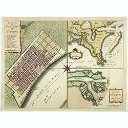
Grondvlakte van Nieuw Orleans de Hoofdstad van Louisiana. / De uitloop van de Rivier Missisippi./ De Oostelijke ingang van de Missisippi. . .
A sought-after, beautiful, decorative sheet that shows three maps arranged around a significant compass rose. This work represents Tirion's version of a first executed ma...
Date: Amsterdam, 1765
Selling price: ????
Please login to see price!
Sold in 2017
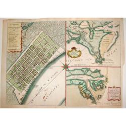
Grondvlakte van Nieuw Orleans, de Hoosdstad van Louisiana / De Uitloop van de Rivier Missisippi / De oostelyke Ingang van de Missisippi, met een Plan van het Fort, 't Welk het Kanaal Beheerscht
A sought-after, beautiful, decorative sheet that shows three maps arranged around a significant compass rose. This work represents Tirion's version of a map that was firs...
Date: Amsterdam, ca. 1769
Selling price: ????
Please login to see price!
Sold
Grondvlakte van Nieuw Orleans, de Hoosdstad van Louisiana / De Uitloop van de Rivier Missisippi / De oostelyke Ingang van de Missisippi, met een Plan van het Fort, 't Welk het Kanaal Beheerscht
A sought-after, beautiful, decorative sheet that shows three maps arranged around a large compass rose. This work represents Tirion's version of a first executed map by D...
Date: Amsterdam, ca. 1769
Selling price: ????
Please login to see price!
Sold in 2015
Carte de la Louisiane et Pays Voisins..
Uncommon edition of this accurate map centered on Louisiana and extending eastwards as far as the Atlantic seacoast. In lower right engraved "33."From Atlas Por...
Date: Amsterdam, 1773
Selling price: ????
Please login to see price!
Sold in 2019
![[Map of the interior of North America and New Spain] (sheet: No.2)](/uploads/cache/82993-250x250.jpg)
[Map of the interior of North America and New Spain] (sheet: No.2)
An engraved, old colored map showing roads, wooded areas, swamps, and settlements; areas of Native American habitation and the route of the Spanish Galleons. Includes not...
Date: Vienna, 1778
Selling price: ????
Please login to see price!
Sold in 2019
Luigiana Inglese, colla Parte Occidentale della Florida, della Giorgia, e Carolina Meridonale.
A very interesting Italian map based on John Mitchell's important map from 1755. It shows the Gulf Coast from Florida until the Mississippi Delta. It includes Biloxi, Pen...
Date: Venice, 1778
Selling price: ????
Please login to see price!
Sold in 2020

Marché Désclaves Pl.XI. / Coton / Ventilateur et Mache.
Plates from the small edition of Diderot's Encyclopaedia. Engraved by Laurent. Very important work as it is giving an inventory of the science and craftsmanship of the 18...
Date: Paris 1779
Selling price: ????
Please login to see price!
Sold
Plan De l'Isle d'Orléans ou Porto Condore. . .
Plan of New Orleans and it direct environs. From "Lettres Édifiantes et Curieuses. . Missionaires de la Compagnie de Jesus [Jesuit Letters]", 2nd Edition, Tome...
Date: Lyon, J. Vernarel and Et. Cabin et C., 1780/1781
Selling price: ????
Please login to see price!
Sold in 2019
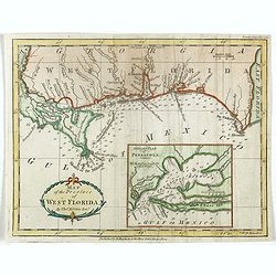
Map of the Province of West Florida. By Tho.s Kitchin.
Scarce map of West Florida, from the May 1781 edition of the London Magazine. Includes a large detailed inset of Pensacola Harbor, including soundings and a not of the st...
Date: London, 1781
Selling price: ????
Please login to see price!
Sold in 2018
Carte De La Louisiane Et Du Cours Du Mississipi Avec Les Colonies Anglaises. Revue, Corrigee et considerablemt. Augmentee en 1782 . . . Par Guillaume De L'Isle. . .
Unrecorded state of De L'Isle's seminal map, substantially updated with information on the British Colonies at the conclusion of the Revolutionary War.Accurate map showin...
Date: Paris, 1782
Selling price: ????
Please login to see price!
Sold in 2013
Carte de la Louisinae, et de Floride.
A handsome map of the American Southeast, including the Mississippi River Valley. The work covers from Charleston, South Carolina, extending west past New Orleans and nor...
Date: ca.1783
Selling price: ????
Please login to see price!
Sold
Partie Méridionale de la Louisiane, avec la Floride, la Caroline et la Virginie..
Fine map of southeastern part of the United States after d'Anville's, to whom Santini gives credit in the cartouche.It covers the Atlantic coastline between the Chesapeak...
Date: Venice, 1776 - 1784
Selling price: ????
Please login to see price!
Sold in 2013
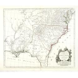
Carte de la Louisiane, et de la Floride.
Handsome map of the American Southeast and the Mississippi River Valley. The map extends from Charleston, South Carolina west to include New Orleans and north well into I...
Date: Paris 1787
Selling price: ????
Please login to see price!
Sold
Carte de la Louisiane, et de la Floride.
Handsome map of the American Southeast and the Mississippi River Valley. The map extends from Charleston, South Carolina west to include New Orleans and north well into I...
Date: Paris, 1787
Selling price: ????
Please login to see price!
Sold
Carte des deux Florides et de la Louisiane inférieure : dressee pour les voyages de Mr. Robin dans les annees 1802, 1803, 1804, 1805 et 1806. . .
Very detailed map by J.B. Poirson, which shows all of Florida and Georgia, Louisiana north to Arkansas with the Ozarks clearly delineated, and east Texas with its rivers ...
Date: Paris, F. Buisson,1807
Selling price: ????
Please login to see price!
Sold in 2010
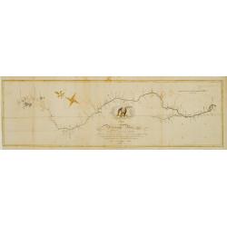
Map of the Mississippi River from its source to the mouth of the Missouri..
Very rare map, one of the first maps of the Mississippi River with its tributaries, giving latitude and longitude markings along the way. Prepared during Zebulon Montgome...
Date: Baltimore 1811
Selling price: ????
Please login to see price!
Sold
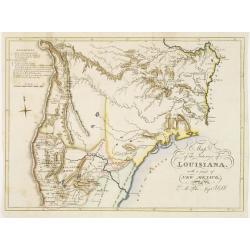
Map of the interior of Louisiana with part of New Mexico..
Engraved by Haase. A mile stone map of the internal part of Louisiana, including the Mississippi in the East and the Mountains of Mexico in the West: with a part of New M...
Date: London 1811
Selling price: ????
Please login to see price!
Sold
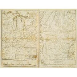
Country drained by the Mississippi Eastern Section. (with) Country of the Mississippi.
Rare map in two sheets stretching from Mississippi to Lake Superior. An inset box at top right includes a series of explanations to the symbols on the map. From: "Ac...
Date: Philadelphia, 1823
Selling price: ????
Please login to see price!
Sold
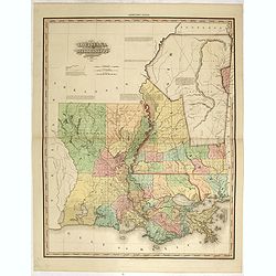
Louisiana and Mississippi by H.S. Tanner. Improved to 1825
A very fine example of the revised 1825 issue of Henry Schenk Tanner's important map of Louisiana and Mississippi. "Improved to 1825" has been added to the titl...
Date: Philadelphia, Henry Tanner, 1825
Selling price: ????
Please login to see price!
Sold in 2015
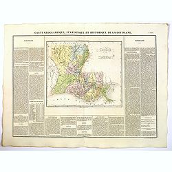
Carte Geographique, Statistique et Historique de Louisiane.
A nice detailed map of the state of Louisiana from Buchon's Atlas Gégraphique Statistique, historique et chronologique des deux Ameriques et des isles adjacentes traduit...
Date: Paris, 1825
Selling price: ????
Please login to see price!
Sold in 2022
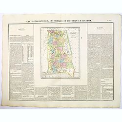
Carte Geographique, Statistique et Historique de d'Alabama.
A nice detailed map of the state of Alabama from Buchon's Atlas Gégraphique Statistique, historique et chronologique des deux Ameriques et des isles adjacentes traduit d...
Date: Paris, 1825
Selling price: ????
Please login to see price!
Sold in 2019
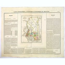
Carte Geographique, Statistique et Historique de Mississipi.
A nice detailed map of the state of Mississippi from Buchon's Atlas Gégraphique Statistique, historique et chronologique des deux Ameriques et des isles adjacentes tradu...
Date: Paris, 1825
Selling price: ????
Please login to see price!
Sold in 2020
