Browse Listings in America > North America > North Pole
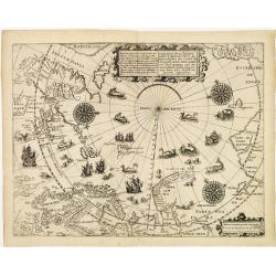
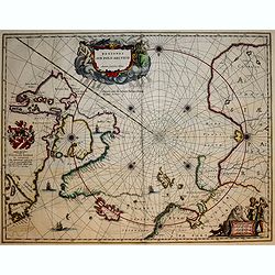
Deliniatio cartae trium navigationum per Batavos..
A major landmark in Arctic cartography incorporating recent voyages including Barents' third voyage to this region, made in 1596-7. A derivative of Willem Barentsz's map ...
Date: Frankfurt 1599
Selling price: ????
Please login to see price!
Sold
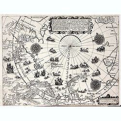
Deliniatio cartae trium navigationum per Batavos. . .
A major landmark in Arctic cartography incorporating recent voyages including Barents' third voyage to this region, made in 1596-7. A derivative of Willem Barentsz's map ...
Date: Frankfurt, 1599
Selling price: ????
Please login to see price!
Sold in 2012
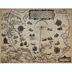
Deliniatio cartae trium navigationum per Batavos..
A major landmark in Arctic cartography incorporating recent voyages including Barents' third voyage to this region, made in 1596-7. A derivative of Willem Barentsz's map ...
Date: Frankfurt, 1599
Selling price: ????
Please login to see price!
Sold in 2017
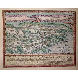
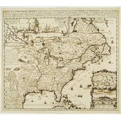
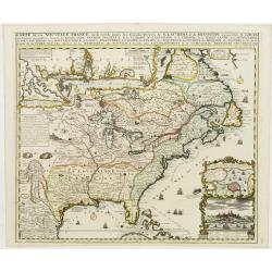
Novi Orbis Pars America. . .
Published in Cologne in 1600 this map is from 'Geographisch Handtbuch' with German text on the verso.Quad's map of North America is derived from De Jode and is a beautifu...
Date: Cologne, 1600
Selling price: ????
Please login to see price!
Sold in 2013
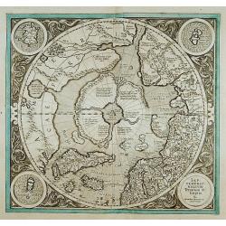
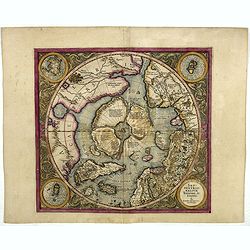
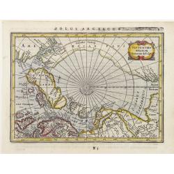
SEPTENTRIONALIUM Terrarum descriptio. Per Gerardum Mercatore
State 2. This is the first map devoted to the Arctic, a hemispherical one on a North Polar projection with an attractive floral design surrounding it. In the corners are ...
Date: Amsterdam 1609
Selling price: ????
Please login to see price!
Sold
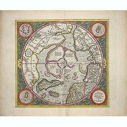
SEPTENTRIONALIUM Terrarum descriptio. Per Gerardum Mercatore.
State 2. This is the first map devoted to the Arctic, a hemispherical one on a North Polar projection with an attractive floral design surrounding it. In the corners are ...
Date: Amsterdam, 1609
Selling price: ????
Please login to see price!
Sold in 2013
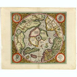
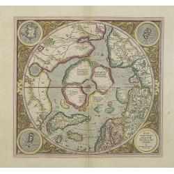
Septentrionalium Terrarum descriptio. Per Gerardum Mercatorem Cum Privilegio.
State 2. This is the first map devoted to the Arctic, a hemispherical one on a North Polar projection with an attractive floral design surrounding it. In the corners are ...
Date: Amsterdam, 1609
Selling price: ????
Please login to see price!
Sold in 2015
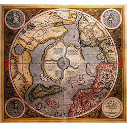
Septentrionalium Terrarum descriptio
This influential map was the first separately printed map devoted to the Arctic. The hemisphere is surrounded by a floral design with four roundels in each corner. These ...
Date: Amsterdam, 1611
Selling price: ????
Please login to see price!
Sold in 2011
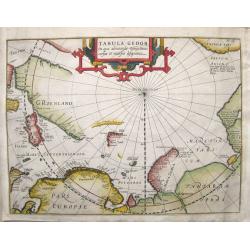
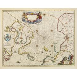
Tabula Geogr. in qua admirandae navigationis cursus et recursus designatur.
First state of a very early and scarce map of the North Pole and Arctic regions showing recent discoveries including the voyage of Jan Willem Barentsz on his quest to fin...
Date: Amsterdam, 1611
Selling price: ????
Please login to see price!
Sold in 2016
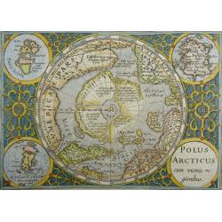
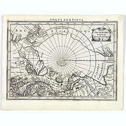
Polus Arcticus cum vicinis regionibus
Excellent early map of the North Polar regions, based upon early maps by Mercator and Hondius.Shows the mythical land masses near the pole, the clearly navigable NW and N...
Date: Amsterdam, 1613
Selling price: ????
Please login to see price!
Sold in 2023
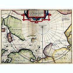
Tabula Geogr. In qua admirandae navigatonis..
A finely engraved map by Jodocus Hondius with coastline details of northern Europe, Greenland, Frisland, Strait Anian with America pars. With the track of a Willem Barent...
Date: Amsterdam, 1614
Selling price: ????
Please login to see price!
Sold in 2019
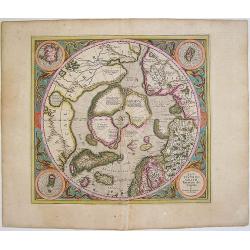
SEPTENTRIONALIUM Terrarum descriptio. Per Gerardum Mercatore
State 2. This is the first map devoted to the Arctic, a hemispherical one on a North Polar projection with an attractive floral design surrounding it. In the corners are ...
Date: Amsterdam, 1623
Selling price: ????
Please login to see price!
Sold in 2016
SEPTENTRIONALIUM Terrarum descriptio. Per Gerardum Mercatore
State 2. This is the first map devoted to the Arctic, a hemispherical one on a North Polar projection with an attractive floral design surrounding it. In the corners are ...
Date: Amsterdam, 1623
Selling price: ????
Please login to see price!
Sold in 2019
Septentrionalium Terrarum decsript.
A good example of Mercator-Jansson's small map of the North Polar regions.The map is extended to 60 degrees, to show the recent explorations in search of the North West a...
Date: Amsterdam, ca. 1628
Selling price: ????
Please login to see price!
Sold in 2017
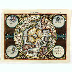
Septentrionalium Terrarum descriptio.
The classic map of the Arctic region, representing the late Medieval concept of four islands surrounding a centralized whirlpool. This polar depiction was an expansion of...
Date: Amsterdam, 1630
Selling price: ????
Please login to see price!
Sold in 2009
Septentrionalium Terrarum descriptio.
Artic pole map from the rare Cloppenburg edition slightly larger format and more scarce edition of the Mercator/Hondius "Atlas Minor". The classic map of the Ar...
Date: Amsterdam, 1630
Selling price: ????
Please login to see price!
Sold in 2020
Regiones Sub Polo Arctico.
One of the many cases of duplication by the firms of Blaeu and Hondius/Jansson. In this case, Blaeu has copied Jansson's map of 1637. It depicts rhumb lines radiating fro...
Date: Amsterdam, 1640
Selling price: ????
Please login to see price!
Sold in 2009
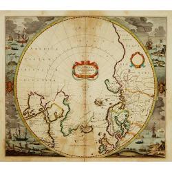
Poli Arctici et Circumiacentium Terrarum Descriptio.
A circular map showing north of Europe and United States. The map is surrounded by scenes of fishing whales.
Date: Amsterdam 1639-1644
Selling price: ????
Please login to see price!
Sold
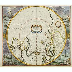
Poli Arctici et Circumiacentium Terrarum Descriptio.
A circular map showing north of Europe and United States. The map is surrounded by scenes of fishing whales. Cartographically the map incorporates much of the knowledge g...
Date: Amsterdam, 1639-1644
Selling price: ????
Please login to see price!
Sold in 2012
Regiones Sub Polo Arctico.
A fine Blaeu version of the Janssonius map of 1637. It depicts rhumb lines radiating from the North Pole. A large title cartouche, with two figures and numerous wind head...
Date: Amsterdam, 1647
Selling price: ????
Please login to see price!
Sold in 2017
Septentrionalium Terrarum Descript.
Detailed miniature map of the North Pole, from a German text edition of his Atlas Minor. Engraved by Petrus Kaerius.
Date: Amsterdam (1628) 1648
Selling price: ????
Please login to see price!
Sold
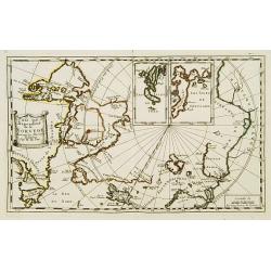
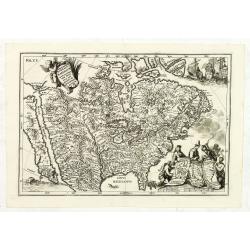
Pais qui dependent de la Norvege suivant les derniers relations.
Rare map of the North Pole. With inset maps of Faeroe and Shetland Islands.
Date: Paris 1650
Selling price: ????
Please login to see price!
Sold
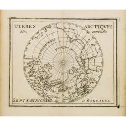
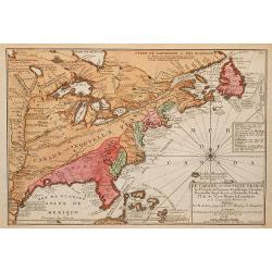
Terres Arctiques.. Septemtrional et Boreales.
Uncommon miniature map of the North Pole, including Iceland, the coast of Russia, Greenland, etc, from Pierre Duval's La Geographie Universeille dated 1676. Following his...
Date: Paris, 1676
Selling price: ????
Please login to see price!
Sold
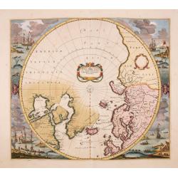
Poli Arctici, et circumiacentium terrarum descriptio novissima. . .
A re-issue of the Hondius' plate, but without the signature. A particularly decorative map of the North Pole. Several Dutch names in Labrador. The toponymy in Canada refl...
Date: Amsterdam, ca.1676
Selling price: ????
Please login to see price!
Sold in 2016
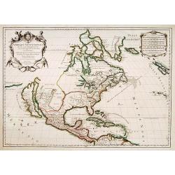
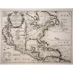
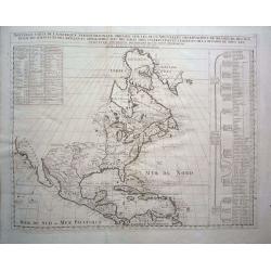
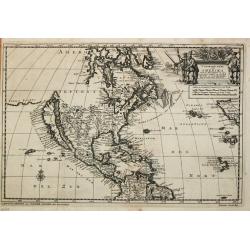
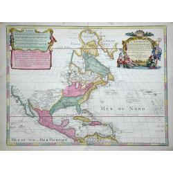
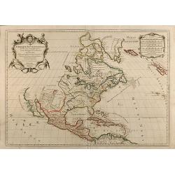
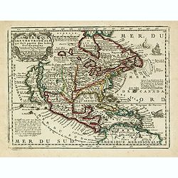
Amerique Septentrionale divisée en ses principales parties?
Impressive map of North America, prepared by Nicolas Sanson and published by Pierre Mortier in Amsterdam. The map is copied from Jaillot's map of 1674 and only some small...
Date: Amsterdam, 1692
Selling price: ????
Please login to see price!
Sold in 2008
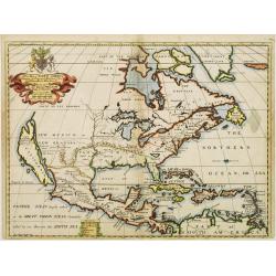
Amérique septentrionale divisée en ses principales parties..
Engraved by Cordier. Spectacular example of Jaillot's map of North America, showing California as an Island, based upon Sanson's landmark map of 1656. This map shows the ...
Date: Paris, 1695
Selling price: ????
Please login to see price!
Sold
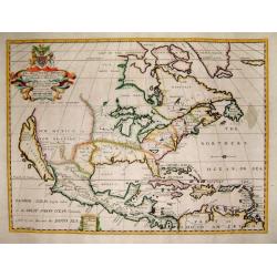
Amerique septentrionale / divisee en ses principales parties. Paris, 1695.
Alexis-Hubert Jaillot (1632-1712), French cartographer. He joined the Sanson heirs and redrew Nicolas Sanson's maps on a larger scale. 'Atlas Nouveau' (1674), sea-atlas '...
Date: Amsterdam, 1696
Selling price: ????
Please login to see price!
Sold
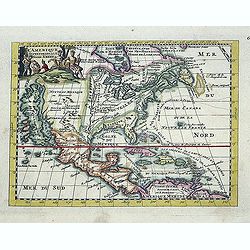
L'Amérique septentrionale et les terres polaires arctique (sic) / dressée par N. de Fer.
An interesting small map of North America by Nicolas de Fer. From his rare "Petit et Nouveau Atlas". The first edition was published in 1697 and was republished...
Date: Paris,1697
Selling price: ????
Please login to see price!
Sold in 2016
Carte d'un Nouveau Monde, entre le Nouveau Mexique et la Mer Glaciale ...
Map of America from Nouveau Voyage d'un Pays plus grand que l'Europe ... by R. P. Louis Hennepin, published in Utrecht in 1698.Based on his 1683 map Carte de la Nouvelle ...
Date: Utrecht, 1698
Selling price: ????
Please login to see price!
Sold in 2014
Nouveau Voyage d'un Pais Plus Grand que l'Europe.
FIRST EDITION OF THE BOOK. This edition of Hennepin's writings, a continuation of his Nouveau voyage of the previous year, comprises materials about La Salle taken from C...
Date: Utrecht, [E. Voskuyl for] Antoine Schouten, 1698
Selling price: ????
Please login to see price!
Sold
Carte D'un Nouveau Monde, entre le Nouveau Mexique, et la Mer Glacialle Novellement decouvert par le R.P. Louis Hennepin...
Extremely rare second edition of Louis de Hennepin’s map of North America, which incorporates many of the discoveries omitted by Hennepin in the first edition of his ma...
Date: Paris, 1698
Selling price: ????
Please login to see price!
Sold in 2021
Repraesentatio Americae Borealis...
An interesting religious map of North America, showing the Catholic regions illuminated and the Protestant and still uncolonized lands swathed in darkness. California is ...
Date: Munich 1699
Selling price: ????
Please login to see price!
Sold
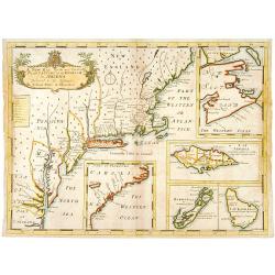
A new map of.. Plantations of the English in America..
"A boldly engraved large-scale map of the Carolinas, Nova Scotia, Bermuda, Barbados and Jamaica appear as large insets on this interesting uncommon and attractive ma...
Date: London 1700
Selling price: ????
Please login to see price!
Sold
L'Amerique Septentrionale dressée sur les Observations de Mrs de l'Academie Royale des Sciences . . .
Rare third state of "L’Amerique Septentrionale. Chez l’Auteur sur le Quai de l’Horloge a la Cour. de Diamans avec Privilege du Roy pour 20 ans, 1700". &qu...
Date: Paris, 1700
Selling price: ????
Please login to see price!
Sold in 2018
Carver's new map of North America. . .
6 maps on a sheet Carver's map of North America, among other maps of Strait Anian.
Date: England, ca. 1700
Selling price: ????
Please login to see price!
Sold in 2020
America borealis 1699.
A map from the series of maps by the Jesuit mathematician. One of the two maps of North America from the series of about six of North America, produced by Scherer to show...
Date: Munich c.1702
Selling price: ????
Please login to see price!
Sold
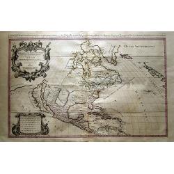
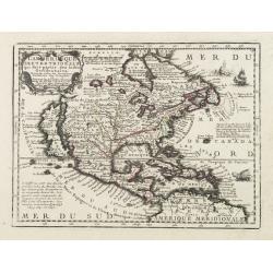
Provinciae Borealis Americae non ita Pridem Detectae aut Magis ab Europaeis Excultae.
This captivating map of North America features a huge island of California, an oversized depiction of the Great Lakes, and a misplaced Mississippi River delta. The interi...
Date: Munich, 1702
Selling price: ????
Please login to see price!
Sold in 2012
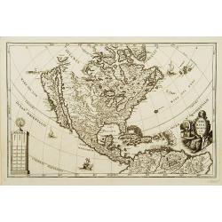
L\'Amerique septentrionale. Noord America.
Map of North and Central America showing California as an island with indented coastline, and with place names R'Estiete, C.Blanco, P.de Carinde, Canal de S. Barbe, I. de...
Date: Amsterdam, 1702
Selling price: ????
Please login to see price!
Sold in 2013
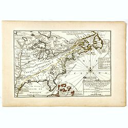
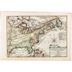
Le Canada, ou Nouvelle France la Florida, la Virginie, Pensilvanie . . .
First edition. This fine map is showing the east coast of the United States from the Caribbean up to Newfoundland, with the western border just beyond the Mississippi.The...
Date: Paris, 1702
Selling price: ????
Please login to see price!
Sold in 2016
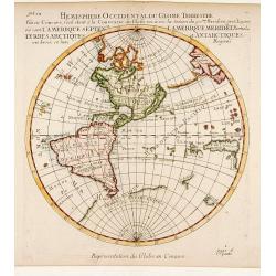
Hemisphere Superieur du Globe Terrestre..
Rare map of Western Hemisphere shown in reverse, but text printed normally. World from internal viewpoint. California with indented northern coast. Terre de Jesso to Nort...
Date: Paris 1704
Selling price: ????
Please login to see price!
Sold
A New Map of North America Shewing its Principal Divisions, Chief Cities, Townes, Rivers, Mountains & c.
A boldly engraved map of North America, showing California as an island. This is a state 4. California as New Abion discovered by Sir Francis Drake Anno 1577 . Traci now ...
Date: London, 1704
Selling price: ????
Please login to see price!
Sold in 2018
A New Map of North America
Title: 'A New Map of North America Shewing its Principal Divisions, Chief Cities, Townes, Rivers, Mountains & c.'. A rare and interesting map of North America. Alth...
Date: London, 1704
Selling price: ????
Please login to see price!
Sold
L'Amerique Septentrionale, ou la Partie Septentrionale des Indes Occidentales ou se Trouve le Canada ou Nouvelle France la Floride la Virginie les Isles Antilles le Nouveau Mexique et la Nouvele Espagne.
“Vincenzo Maria Coronelli’s large two-sheet ‘AMERICA SETTENTRIONALE,’ dated 1688, did not appear in an atlas until 1691, in the first edition of the ‘Atlante Ve...
Date: Paris, 1689-1704
Selling price: ????
Please login to see price!
Sold in 2013
Le Canada, ou Nouvelle France la Florida, la Virginie, ? Misispi
Fine map of the eastern coast of North America. Engraved by Herman van Loon, a Dutch engraver active in Amsterdam, after 1686 in Paris. ¤
Date: Paris, 1705
Selling price: ????
Please login to see price!
Sold in 2009
Nouvelle Carte de l\' Amerique Septentrionale dressee sur les plus Nouvelles Observations de Messieurs de l\' Academie des Sciences et des Meilleurs Geographes avec des tables tres instructives et curieuses de la division de tous les Etats.
From: Atlas Historique. A fine folio map with California as an island. All five of the Great Lakes are present; but Lake Erie is unnamed. The Ohio River is shown, but unn...
Date: Amsterdam, 1705
Selling price: ????
Please login to see price!
Sold in 2014
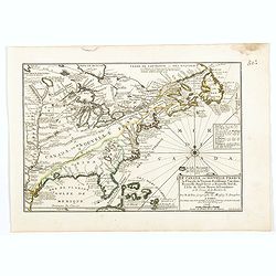
Le Canada, ou Nouvelle France la Florida, la Virginie, Pensilvanie . . .
Fine map is showing the east coast of the United States from the Caribbean up to Newfoundland, with the western border just beyond the Mississippi.The course of the Missi...
Date: Paris, 1705
Selling price: ????
Please login to see price!
Sold in 2019
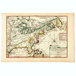
Le Canada, ou Nouvelle France la Florida, la Virginie, Pensilvanie . . .
Fine map is showing the east coast of the United States from the Caribbean up to Newfoundland, with the western border just beyond the Mississippi.The course of the Missi...
Date: Paris, 1705
Selling price: ????
Please login to see price!
Sold in 2020
Le Canada, ou Nouvelle France la Florida, la Virginie, Pensilvanie . . .
A fine map is showing the east coast of the United States from the Gulf of Mexico and the Caribbean up to Newfoundland, with the western border just beyond the Mississipp...
Date: Paris, 1705
Selling price: ????
Please login to see price!
Sold in 2021
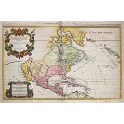
![L'AMERIQUE SEPTENTRIONALE.[California island]](/uploads/cache/85225-250x250.jpg)
L'AMERIQUE SEPTENTRIONALE.[California island]
A map of North and Central America showing California as a hugh island stretching as far north as Alaska with indented coastline, and with the place names of: R'Estiete, ...
Date: Amsterdam, 1706
Selling price: ????
Please login to see price!
Sold in 2021
' T noorder Deel van Amerika.
Pieter van der Aa was a prolific publisher. He published a.o. ' Naauwkeurge versameling der gedenkwaardigste zee- en land-reysen', a series of accounts of voyages (1706-0...
Date: Leiden, 1707
Selling price: ????
Please login to see price!
Sold
Jomathan Dickensons Ramspoedige Reystogt van Jamaika na Pensylvania Nagespond
A scarce Van Der Aa map of Florida and the Carolinas unusually oriented to the east and covering the Great Lakes to Jamaica. A very crisp copy in bright example.
Date: Leiden, 1707
Selling price: ????
Please login to see price!
Sold in 2016
L'Amerique Septentrionale.
Uncommon issue of this decorative map of North America, covering Central America, showing east coast, California, Canada, Caribbean and northern part of South America. Sh...
Date: Amsterdam / Paris 1708
Selling price: ????
Please login to see price!
Sold
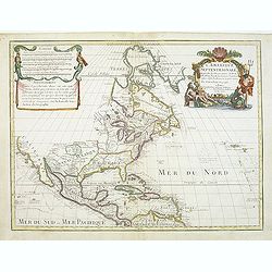
L'AMERIQUE SEPTENTRIONALE Dressée sur les Observations de Mr
One of the most influential maps of North America, laying the groundwork for much of the cartography of the 18th century. This is an early re-issue of De l'Isle's landmar...
Date: Paris, 1700 -1708
Selling price: ????
Please login to see price!
Sold in 2012
L'Amerique Septentrionale. Dressée sur les Observations de Mrs. de l'Academie Royale des Sciences...
Attractive example of De L'Isle's very important map of North America, the first map to show California as a peninsula again. Further it has a better and a more accurate ...
Date: Paris, c1708
Selling price: ????
Please login to see price!
Sold in 2016
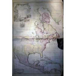
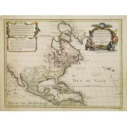
North America corrected from the observations communicated to the Royal Society of London, and the Royal Academy at Paris...
Monumental and important large wall map of the Eastern part of North America with the United States, Central America, and the West Indies. Centered on the great lakes.1st...
Date: London, c 1710
Selling price: ????
Please login to see price!
Sold in 2008
Amerique Septentrionale.
Early and interesting map of North America with large blank parts and California as an island. Names a large Floride. Rey Coromedo Nouveau in todays Arizona, and Coste de...
Date: Paris, ca. 1710
Selling price: ????
Please login to see price!
Sold in 2019
Amerique Septentrionale.
Interesting 1715 quarto-size copy of Sanson's important map of North America, typically found in editions of L'Amerique published from 1656 to 1683. This copy from Chemer...
Date: Utrecht, 1715
Selling price: ????
Please login to see price!
Sold in 2015
Carte du Mexique et de la Floride des Terres Angloises et des Isles Antilles du Cours et des Environs de la Riviere de Mississipi ... Par Guillaume Del\'Isle Geographe de l\'Academie Royale des Scieces.
Rare first edition, second state of the first printed map to accurately depict the course and mouth of the Mississippi River. De L\'Isle\'s Carte du Mexique is drawn from...
Date: Paris, 1703 / 1708-1718
Selling price: ????
Please login to see price!
Sold in 2009
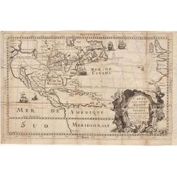
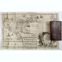
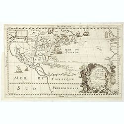
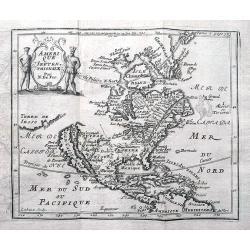
L'Amerique Septentrionale qui fait partie des Indes Occidentales..
A handsome miniature-map showing California as an island after Sanson. Sanson's details are generally followed.The British colonies are shown confined east of the Appalac...
Date: Paris, 1719
Selling price: ????
Please login to see price!
Sold in 2017
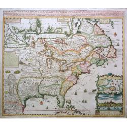
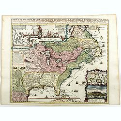
Carte de la Nouvelle France, ou se voi le cours. . .
Derived from de Fer's 1718 map, from west of the Mississippi it contains a mass of inland detail with notes and vignettes of the indigenous peoples and fauna of North Ame...
Date: Amsterdam, 1719
Selling price: ????
Please login to see price!
Sold
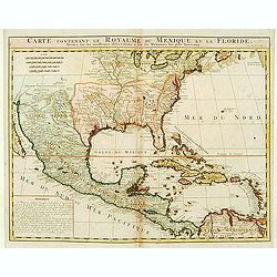
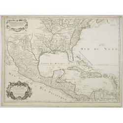
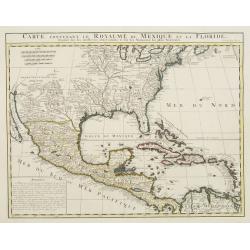
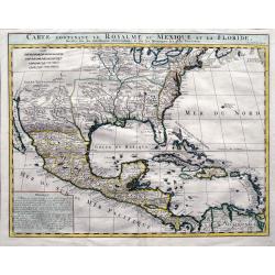
Carte contenant le Royaume du Mexique et la Floride.
This is a derivative of Delisle's landmark map of the southern part of North America. The detailed map shows many English settlements along the East Coast and carefully n...
Date: Amsterdam, 1719
Selling price: ????
Please login to see price!
Sold in 2019
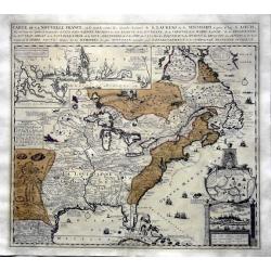
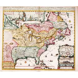
Carte de la Nouvelle France, ou se voi le cours..
Derived from de Fer's 1718 map, from west of the Mississippi it contains a mass of inland detail with notes and vignettes of the indigenous peoples and fauna of North Ame...
Date: Amsterdam 1719
Selling price: ????
Please login to see price!
Sold
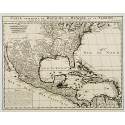
Carte contenant le Royaume du Mexique et la Floride.
ñ This is a derivative of Delisle's landmark map of the southern part of North America. The detailed map shows many English settlements along the East Coast and carefull...
Date: Amsterdam, 1719
Selling price: ????
Please login to see price!
Sold
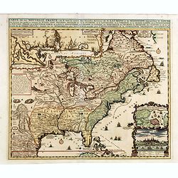
Carte de la Nouvelle France, ou se voi le cours..
Derived from de Fer's 1718 map, from west of the Mississippi it contains a mass of inland detail with notes and vignettes of the indigenous peoples and fauna of North Ame...
Date: Amsterdam 1719
Selling price: ????
Please login to see price!
Sold
Carte contenant le Royaume du Mexique et la Floride.
This is a derivative of Delisle's landmark map of the southern part of North America.The detailed map shows many English settlements along the East Coast and carefully no...
Date: Amsterdam, 1719
Selling price: ????
Please login to see price!
Sold
Carte de la Nouvelle France, ou se voi le cours..
Derived from de Fer\'s 1718 map, from west of the Mississippi it contains a mass of inland detail with notes and vignettes of the indigenous peoples and fauna of North Am...
Date: Amsterdam, 1719
Selling price: ????
Please login to see price!
Sold in 2009
Amerique Septentrionale divisee en ses Principales Parties
Attractive map of North America. By Jaillot and Sanson. California between island and peninsula. Pacific Northwest is unexplored. Old outline color.
Date: 1719
Selling price: ????
Please login to see price!
Sold in 2010
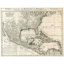
Carte contenant le royaume du Mexique et la Floride.
From Chatelains Atlas Historique. Based upon De L'Isle's landmark map of the region.
Date: Amsterdam, 1719
Selling price: ????
Please login to see price!
Sold in 2009
Carte de la Nouvelle Franc, ou se voi le cours des grandes rivieres. . .
Derived from de Fer's 1718 map, from west of the Mississippi it contains a mass of inland detail with notes and vignettes of the indigenous peoples and fauna of North Ame...
Date: Amsterdam, 1719
Selling price: ????
Please login to see price!
Sold in 2017
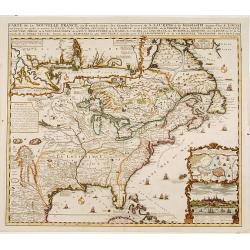
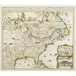
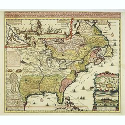
Carte de la Nouvelle France, où se voit le cours des Grandes Rivières de S. Laurens & de Mississipi
An intricate map of eastern North America was copied from De Fer and designed to show the courses of the St. Laurence and the Mississippi rivers. One inset charts the mou...
Date: Amsterdam, 1719
Selling price: ????
Please login to see price!
Sold in 2013
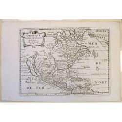
L'Amerique Septentrionale qui fait partie des Indes Occidentales..
A handsome miniature-map showing California as an island after Sanson. Sanson's details are generally followed.The British colonies are shown confined east of the Appalac...
Date: Paris, 1719
Selling price: ????
Please login to see price!
Sold in 2014
Carte De La Nouvelle France, ou se voit le cours des Grandes Rivieres de. S. Laurens & de Mississipi Aujour d'hui S. Louis, Aux Environs des-quelles se trouvent les Etats, Pais, Nations, Peuples &c. de la Floride, de la Louisiane, de la Virginie, de la M
Nice original old color rare single sheet map of the inhabited parts of North America. This map is based on the 4-sheet map by Nicholas De Fer which appeared in 1718.This...
Date: Paris, 1719
Selling price: ????
Please login to see price!
Sold in 2016
Carte de la Nouvelle France, ou se voi le cours..
Derived from de Fer's 1718 map, from west of the Mississippi it contains a mass of inland detail with notes and vignettes of the indigenous peoples and fauna of North Ame...
Date: Amsterdam, 1719
Selling price: ????
Please login to see price!
Sold
Carte de la Nouvelle France, ou se voi le cours..
Derived from de Fer's 1718 map, from west of the Mississippi it contains a mass of inland detail with notes and vignettes of the indigenous peoples and fauna of North Ame...
Date: Amsterdam, 1719
Selling price: ????
Please login to see price!
Sold in 2022
Carte de la Nouvelle France, ou se voi le cours. . .
Derived from de Fer's 1718 map, from west of the Mississippi it contains a mass of inland detail with notes and vignettes of the indigenous peoples and fauna of North Ame...
Date: Amsterdam, 1719
Selling price: ????
Please login to see price!
Sold in 2019
Carte contenant le Royaume du Mexique et la Floride. . .
A double-page engraved map of Texas, Florida, the Gulf Coast, and Central America, based on Guillaume De L'Isle's important Carte du Mexique. It shows parts of the Great ...
Date: Amsterdam, 1719
Selling price: ????
Please login to see price!
Sold in 2019
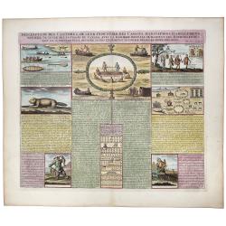
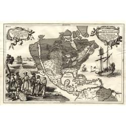
Inscription des Castors & De Leur Industrie des Canots Habitations Habillemens, maniere de vivre des sauvages du Canada. . .
A very unique sheet of various engravings concerning Native American customs and indigenous animals in North America. Includes a large view of an American buffalo and a g...
Date: Paris, ca 1719
Selling price: ????
Please login to see price!
Sold in 2020
![Carte Qui Contient la Mantere don't se Fait La Chasse des Boeufs Sauvages et des Elans, Le Grand Saut de la riviere de Niagar a la danse du Calumet. . .[NIAGARA FALLS..]](/uploads/cache/83653-250x250.jpg)
Carte Qui Contient la Mantere don't se Fait La Chasse des Boeufs Sauvages et des Elans, Le Grand Saut de la riviere de Niagar a la danse du Calumet. . .[NIAGARA FALLS..]
A beautiful colored chart showing the Natives of Canada. A very unique sheet of various engravings concerning Native American customs and indigenous animals in North Amer...
Date: Paris, 1719
Selling price: ????
Please login to see price!
Sold in 2020
![L'Amerique Septentrionale qui fait partie des Indes Occidentales . . . [California island]](/uploads/cache/85233-250x250.jpg)
L'Amerique Septentrionale qui fait partie des Indes Occidentales . . . [California island]
A fine example of the 1719 Chiquet's map of North America, with the accompanied related engraved French text sheet entitled "Description Abregé de l'Amerique Septen...
Date: Paris, 1719
Selling price: ????
Please login to see price!
Sold in 2021
Amplissimae Regionis Mississipi,.. Provinciae Ludovicianae
Attractive map of present-day U.S. from Nouveau Mexico to the Atlantic, centring on the French province of Louisiana, with the English colonies and Spanish Florida indica...
Date: Nuremberg 1720
Selling price: ????
Please login to see price!
Sold
