Browse Listings in America > North America
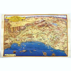
Ride the Roads to Romance along the Golden Coast...
A fun, large folding touring map of the Golden Coast and through the Sunshine Empire of southern California. From just north of Malibu Beach down past San Diego to Ensena...
Date: California, 1952
Selling price: ????
Please login to see price!
Sold in 2016
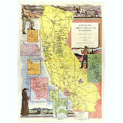
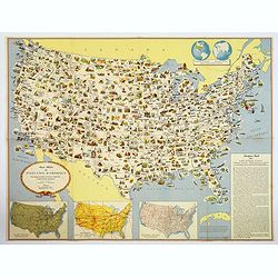
A Map of the Marked Historical Sites of California.
A large, colorful and impressive map of the American state of California, showing the historical sites of the state. There are 496 numbered sites depicted on the map.In a...
Date: California, 1952
Selling price: ????
Please login to see price!
Sold in 2018
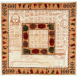
A Map of Downtown Chicago.
Silk map of Chicago’s Loop issued to celebrate the 100th anniversary of Marshall Field & Company.Though it nominally functions as a map of Chicago’s downtown, the...
Date: United-states, 1952
Selling price: ????
Please login to see price!
Sold in 2021
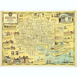
Historical Map of Old Baltimore.
A lovely, detailed map of the old 'downtown' area of Baltimore.
Date: Baltimore, 1954
Selling price: ????
Please login to see price!
Sold in 2017
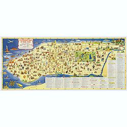
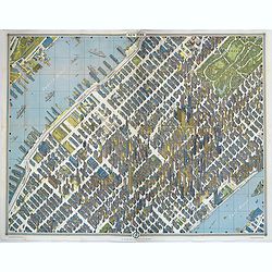
Colorgraph Map of New York.
A colorful, lively map of lower Manhattan, from Harlem south to the Battery. Numerous (380) small color illustrations throughout, depicting all that life in NYC has to of...
Date: New York, 1954
Selling price: ????
Please login to see price!
Sold in 2017

Historical Map of Old Baltimore.
A lovely, detailed map of the old 'downtown' area of Baltimore, with its streets well laid out, with numerous small vignette pictures illustrating historic events and ill...
Date: Baltimore, 1954
Selling price: ????
Please login to see price!
Sold in 2019
Within the Golden Gate. A survey of the History, Resources, and Points of Interest. . .
A nicely produced brochure of the area around San Francisco, with a delightful fully colored pictorial map of the area as the front and back covers for the brochure. The...
Date: San Francisco, 1955
Selling price: ????
Please login to see price!
Sold in 2020
A Pictorial Map of Southern California and adjacent areas.
A beautiful folding map of Southern California, taking the geography from San Francisco to San Diego and the Mexican border. As well as plenty of physical map detail, the...
Date: Los Angeles, ca. 1960
Selling price: ????
Please login to see price!
Sold in 2017
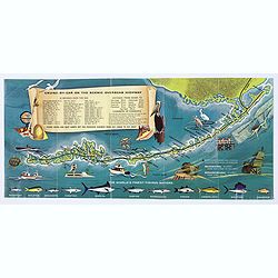
Florida Keys & Key West. . .
A folding map (brochure) advertising the many attractions of the Florida Keys and Key West. Map. The map is illustrated by a number of cartoonish vignettes of local wildl...
Date: Miami, aftrer 1960
Selling price: ????
Please login to see price!
Sold in 2020
![[Golden Gate Bridge San Francisco]](/uploads/cache/46709-250x250.jpg)
[Golden Gate Bridge San Francisco]
Signed lithograph view of the Golden Gate Bridge in San Francisco, by E.R.
Date: ca. 1960
Selling price: ????
Please login to see price!
Sold in 2020
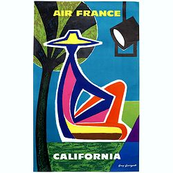
California.
"CALIFORNIA" advertising poster for AIR France, design by Guy Georget (1911-1992).His “California” poster from 1963 flirts with cubism. The white outline ar...
Date: Paris, S.A.Courbet, 1963
Selling price: ????
Please login to see price!
Sold in 2020

New York.
Perhaps one of the greatest cartographic feats of all time, this 1963 'bird's eye view' map of New York City was the first such produced for almost a century. Amazingly, ...
Date: New York, 1963
Selling price: ????
Please login to see price!
Sold in 2018
New York.
Perhaps one of the greatest cartographic feats of all time, this 1963 'bird's eye view' map of New York City was the first such produced for almost a century. Amazingly, ...
Date: New York, 1963
Selling price: ????
Please login to see price!
Sold in 2019
Carte Illustree des Etats-Unis d'Amerique Principaux produits, resources regionales, et particularites physiques.
A decorative French map of the United States' main products, regional resources and physical features. The map is covered with many small pictorial vignettes highlighting...
Date: Washington D.C., ca. 1965
Selling price: ????
Please login to see price!
Sold in 2018
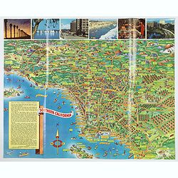
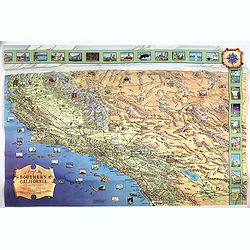
A Pic-Tour map of Southern California.
A highly colorful and attractive pictorial travel map of southern California, from Santa Barbara, southward to San Diego & Tijuana. Major streets, highways, attractio...
Date: San Francisco, ca 1965
Selling price: ????
Please login to see price!
Sold in 2019
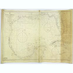
Gulf of Mexico.
A large sea chart of the Gulf of Mexico 'from Admiralty Charts and US Government charts, corrected to 1966'. (In fact there are corrections up until 1977).Chart extent is...
Date: London, 1882 corrected to 1966
Selling price: ????
Please login to see price!
Sold in 2017
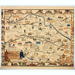
The Main Line. A Historical Map of Ye Outlying Regions . . .
A pictorial map depicting the geography, history and landmarks of the Main Line, the informal name for a group of western suburbs of Philadelphia, Pennsylvania. The area ...
Date: Philadelphia, 1975
Selling price: ????
Please login to see price!
Sold in 2020
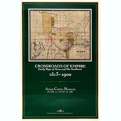
Crossroads of Empire. Early Maps of Texas and the Southwest 1513 - 1900
Poster made for the exhibit 'Crossroads of Empire: Printed Maps of Texas and the Southwest, 1513-1900' at the Amon Carter Museum, Fort Worth" June 11–July 26, 1981...
Date: Fort Worth, 1981
Selling price: ????
Please login to see price!
Sold in 2021

The Military Invasion of American Schools.
An interesting offset colour printed lithograph map / poster of the United States that is liberally covered in symbols of either black triangles or red circles, both high...
Date: New York, 1984
Selling price: ????
Please login to see price!
Sold in 2023

Ronald Reagan.
Original drawing representing a caricature of Ronald Reagan.Born in 1958, Jan Op De Beeck was elected in 2003 as 'World's Best Caricaturist' by the Professional cartoonis...
Date: Belgium, 1987
Selling price: ????
Please login to see price!
Sold
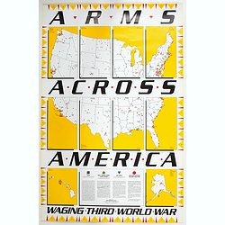
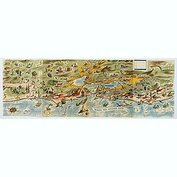
Arms Across America Waging Third World War.
This is a striking propaganda map, created by The War Registers League, founded 100 years ago in the U.S. it continues today as a secular, pacifist organization dedicated...
Date: New York, 1989
Selling price: ????
Please login to see price!
Sold in 2023
