Browse Listings in America
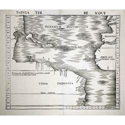
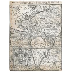
Tabula Terre Nove.
Waldseemuller's map of the New World shows the Atlantic coast of the Americas from latitudes 35 degrees south to 55 degrees north, including 20 place-names on the North A...
Date: Basle c.1513/1520
Selling price: ????
Please login to see price!
Sold
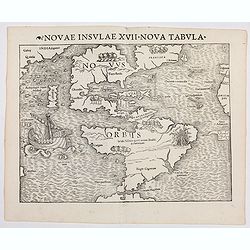
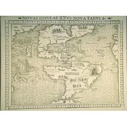
Novae Insulae XXVI Nova Tabula (America)
Rare first state of Münster's map of America which is the earliest map to show both continents of America and the first to use Magellan’s name, Mare Pacificum (Pacific Oc...
Date: Basel, (1540) 1542
Selling price: ????
Please login to see price!
Sold in 2022
Discovery of America.
The discovery of America by Christopher Columbus from the Cosmographia by Sebastian Münster (ca 1544), on a full leaf. A second full leaf is added with the description of...
Date: Basel, 1544
Selling price: ????
Please login to see price!
Sold in 2020
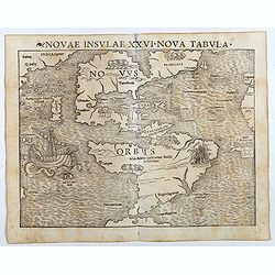
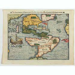
Novae Insulae XXVI Nova Tabula (America)
Rare second state of Münster's map of America which is the earliest map to show both continents of America and the first to use Magellan’s name, Mare Pacificum (Pacific O...
Date: Basel, Heinrich Petri, 1545
Selling price: ????
Please login to see price!
Sold in 2017
Terra Nueva
Gastaldi's map of Eastern USA from Giacomo Gastaldi's Atlas of 1548 which has been called the most comprehensive atlas, produced between Martin Waldseemüller's Geographia...
Date: Venice, 1548
Selling price: ????
Please login to see price!
Sold in 2023
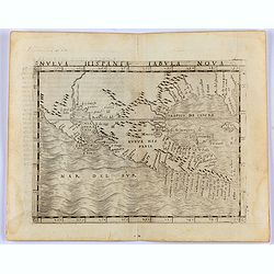
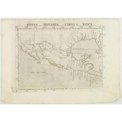
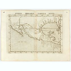
Nueva Hispania Tabula Nova.
Gastaldi's map of Mexico and Texas, from Giacomo Gastaldi's 1548 Atlas, which has been called the most comprehensive atlas, was produced between Martin Waldseemüller's Ge...
Date: Venice, 1548
Selling price: ????
Please login to see price!
Sold in 2021
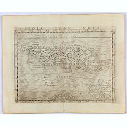
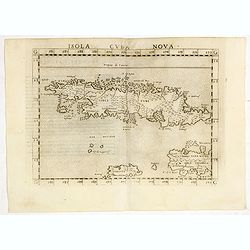
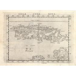
Insula Cuba Nova.
One of the earliest separately published maps of Cuba, with the Yslas de Lagartos (Cayman Islands). The map includes early appearances of Iamayea (Jamaica), Isola Espanol...
Date: Venice, 1548
Selling price: ????
Please login to see price!
Sold in 2021
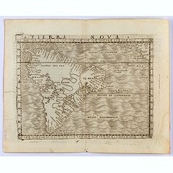
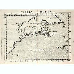
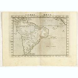
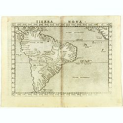
Tierra Nova
Gastaldi's map of South America from Giacomo Gastaldi's Atlas of 1548 which has been called the most comprehensive atlas, produced between Martin Waldseemüller's Geograph...
Date: Venice, 1548
Selling price: ????
Please login to see price!
Sold in 2022
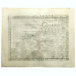
Tabula novarum insularum, quas diversis respectibus Occidentalis et Indianas vocant.
The earliest separate map to show both North and South America. One of the first maps also to include Japan, and the first to refer to Mare Pacificum or the Pacific Ocean...
Date: Basle, 1550
Selling price: ????
Please login to see price!
Sold in 2013
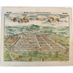
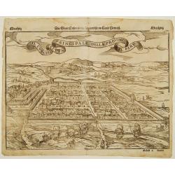
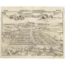
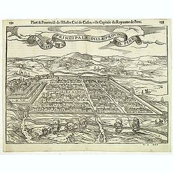
Der Statt Cusco / so die fuernembste im Land Peru / Il Cuscho Citta Principale della Provincia del Peru.
An early woodcut view of Cusco (Cuzco) in Peru by Sebastian Munster on a full double sheet. One of the earliest views of a city in the 'New World'. Verso an early woodcut...
Date: Basel, H.Petri, ca. 1550
Selling price: ????
Please login to see price!
Sold in 2019
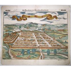
Il Cuscho Citta Principale Della Provincia Del Peru.
A 1550's decorative bird's-eye view of Cusco, from a German edition of Münster's 'Cosmographia', one of the most influential geographical works of the 16th century. One o...
Date: Basel, ca 1550
Selling price: ????
Please login to see price!
Sold in 2020
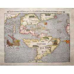
Die Neuwen Inseln so Hinder Hispanien Gegen Orient bey dem Land Indie Ligen
This is an authentic, antique map of the Western Hemisphere showing North and South America connected as true continents. It is the 5th state example published out of Bas...
Date: Basel, 1550
Selling price: ????
Please login to see price!
Sold in 2023
Novae Insulae XXVI Nova Tabula.
The earliest separate map of the western hemisphere, first published in the 1540 edition of Münster's "Geographia" and reprinted for subsequent editions of the ...
Date: Basel, 1552
Selling price: ????
Please login to see price!
Sold in 2011
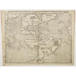
La table des Isles neufves, lequelles on appelle isles d'occident & d'Indie pour divers regardz
The rare 1552 edition of Münster's map showing all of North and South America. Münster's map is the earliest map to show all of the continent of America and the first to ...
Date: Basel, 1552
Selling price: ????
Please login to see price!
Sold in 2018
Tabula novarum insularum, quas diversis respectibus Occidentales & Indianas vocant.
The earliest separate map of the western hemisphere. State 5 of the Latin text edition incorporating the words 'Die Nüw Welt' in South America. It was first published in ...
Date: Basel, 1552
Selling price: ????
Please login to see price!
Sold in 2023
Il Cuscho citta principale della provincia del Peru.
A very desirable item of this decorative and early bid's-eye view of the Inca city of Cuzco, based on Antoine du Pinet's depiction of the city. Several figures shown insi...
Date: Basle 1555
Selling price: ????
Please login to see price!
Sold
Il Cuscho citta principale della provincia del Peru.
A very desirable item of this decorative and early bid's-eye view of the Inca city of Cuzco, based on Braun & Hogenberg's depiction of the city. Several figures shown...
Date: Basle, 1555
Selling price: ????
Please login to see price!
Sold
Brasil.
A fantastic pictorial map of Brazil, shown north to the right. This graphic woodblock map, prepared by the great Venetian cartographer Giacomo Gastaldi and is filled with...
Date: Venice about 1556
Selling price: ????
Please login to see price!
Sold
Nova Francia.
RARE FIRST STATE of the woodcut map of the Atlantic coastline from New York to Labrador. Manhattan as the peninsula "Angouleme", named after King Francis I, Duk...
Date: Venice 1556
Selling price: ????
Please login to see price!
Sold
Brasil.
A fantastic pictorial map of Brazil, shown north to the right. This graphic woodblock map, prepared by the great Venetian cartographer Giacomo Gastaldi and is filled with...
Date: Venice ca. 1556
Selling price: ????
Please login to see price!
Sold
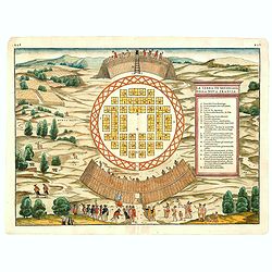
(MONTREAL). La Terra de Hochelaga nella Nova Francia.
The first printed plan of Montreal, from Delle navigationi et viaggi, and prepared Jacques Cartier, the great French explorer. visited the village of Hochelaga on the isl...
Date: Venice, 1556
Selling price: ????
Please login to see price!
Sold in 2014
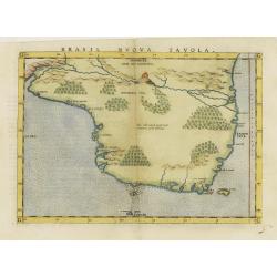
Brasil nuova tavola.
Uncommon first edition of this early map of Brazil. West to the top.Girolamo Ruscelli's edition of Ptolemy's Geographia included newly engraved copperplates by Giulio and...
Date: Venice, 1561
Selling price: ????
Please login to see price!
Sold in 2020
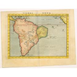
Tierra Nova.
Uncommon first edition of this early map of South America.Girolamo Ruscelli\'s edition of Ptolemy\'s Geographia included newly engraved copperplates by Giulio and Livio S...
Date: Venice, 1561
Selling price: ????
Please login to see price!
Sold in 2009
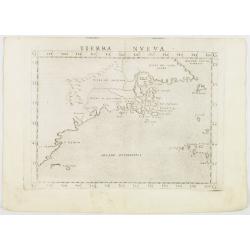
Tierra Nveva.
Rare first edition of the map of east coast of North America..According to Shirley, most likely engraved by the brothers Giulio and Livio Sanuto. Ptolemaic world map, con...
Date: Venise, 1561
Selling price: ????
Please login to see price!
Sold in 2008
Nueva Hispania tabula nova.
Uncommon first edition of this early map of New Spain, Florida and Gulf of Mexico. The map is an enlarged version of Giacomo Gastaldi's published in 1548. Nomenclature an...
Date: Venice, 1561
Selling price: ????
Please login to see price!
Sold in 2008
Tierra Nveva.
Early map of the east coast is an enlarged version of Giacomo Gastaldi's published in 1548. Nomenclature and cartography are unchanged, with the exception of the depictio...
Date: Venise, 1561
Selling price: ????
Please login to see price!
Sold in 2012
Isola Cuba Nova.
Scarce FIRST edition of this map depicting the island of Cuba - one of the earliest separately published maps of Cuba. Also includes Jamaica and northwestern Hispaniola a...
Date: Venice, 1561
Selling price: ????
Please login to see price!
Sold in 2020
Tierra Nova.
Scarce FIRST edition of this map depicting South America, extending from Labrador to Jamaica. The map is based upon a map published by Giacomo Gastaldi in 1548. One of th...
Date: Venice, 1561
Selling price: ????
Please login to see price!
Sold in 2017
Tierra Nova.
Scarce FIRST edition of this map depicting South America, extending from Labrador to Jamaica. The map is based upon a map published by Giacomo Gastaldi in 1548. One of th...
Date: Venice, Vincenzo Valgrisi, 1561
Selling price: ????
Please login to see price!
Sold in 2018
Nueva Hispania tabula nova.
Uncommon first edition of this early map of New Spain, Florida and Gulf of Mexico. The map is an enlarged version of Giacomo Gastaldi's map published in 1548. Nomenclatur...
Date: Venice, 1561
Selling price: ????
Please login to see price!
Sold in 2024
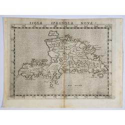
Isola Spagnola Nova.
One of the earliest separately published maps of Hispaniola, from an early edition of Ruscelli's version of Ptolemy's Geography, published in 1561. Ruscelli's map is a la...
Date: Venice, 1562
Selling price: ????
Please login to see price!
Sold in 2019
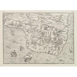
Il Cuscho citta principale della provincia del Peru.
A very desirable and scarce item of this decorative and early bid's-eye town-plan of the Inca city of Cuzco. Several figures shown inside the city walls and on the hillsi...
Date: Lyons, 1564
Selling price: ????
Please login to see price!
Sold in 2012
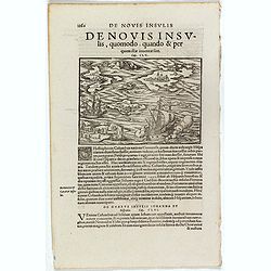
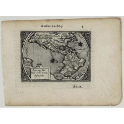
De Novis Insulis, Quomodo quando . . .
Text page with a map of unspecified islands in the New World (140 x 145 mm). with sea monsters on the recto. From Münster's Cosmographia Universalis.The Cosmographia by S...
Date: Basle, ca. 1564
Selling price: ????
Please login to see price!
Sold in 2017
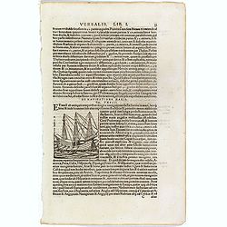
De Navigatione Maris.
One Latin text page about navigation, early voyages, and illustrated with a ship (68 x 64 mm), who was lateron used to illustrate Christopher Columbus ship. On verso an i...
Date: Basle, ca. 1564
Selling price: ????
Please login to see price!
Sold in 2018
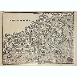
La Nuova Francia.
Second state of the woodcut map of the Atlantic coastline from New York to Labrador. Manhattan as the peninsula "Angouleme", named after King Francis I, Duke of...
Date: Venice, 1565
Selling price: ????
Please login to see price!
Sold in 2012
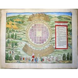
La Terra de Hochelaga nella Nova Francia... (MONTREAL).
Large, very rare woodcut depicting the first printed plan of Montreal, from the famous book "Delle navigationi et viaggi", prepared Jacques Cartier, the great F...
Date: Venice, ca 1565
Selling price: ????
Please login to see price!
Sold in 2019
Isola Cuba Nova
This important Ruscelli map of Cuba from his work La Geografia di Claudio Tolomeo Alessandrino, is based on Gastaldi’s earlier map of the same region, dated 1548. Althoug...
Date: Venice, 1570
Selling price: ????
Please login to see price!
Sold in 2023
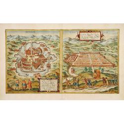
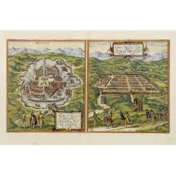
Mexico. & Cusco regni Peru in novo orbe caput.
From part one of the "Civitates", the only view in the entire work to depict cities of the New World. Shown here are the great cities of the Aztec and Inca cult...
Date: Antwerp, 1572
Selling price: ????
Please login to see price!
Sold
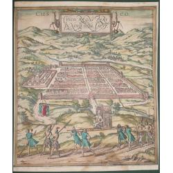
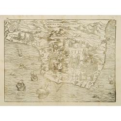
Cusco, Regni Peru in Novo Orbe Caput.
According to George Braun : "The capital of Peru in the south of the New world is Cusco, a city so large, powerful and beautiful that it can easily rank alongside th...
Date: Antwerp, 1572
Selling price: ????
Please login to see price!
Sold in 2014
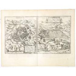
Mexico. & Cusco regni Peru in novo orbe caput.
From part one of the "Civitates", the only view in the entire work to depict cities of the New World. Shown here are the great cities of the Aztec and Inca cult...
Date: Cologne, ca. 1572
Selling price: ????
Please login to see price!
Sold in 2013
![Mexico regia et celebris Hispaniae Novae civitas [with] Cusco regni Peru in novo orbe caput.](/uploads/cache/36845-250x250.jpg)
Mexico regia et celebris Hispaniae Novae civitas [with] Cusco regni Peru in novo orbe caput.
From part one of the "Civitates", the only view in the entire work to depict cities of the New World. Shown here are the great cities of the Aztec and Inca cult...
Date: Antwerp, 1572
Selling price: ????
Please login to see price!
Sold in 2017
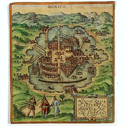
Mexico regia et celebris Hispaniae Novae civitas.
One of the earliest prints of Mexico City and taken from part one of the "Civitates", the only view in the entire work to depict cities of the New World. The vi...
Date: Antwerp, 1572
Selling price: ????
Please login to see price!
Sold in 2018
Mexico. & Cusco regni Peru in novo orbe caput.
From part one of the "Civitates", the only view in the entire work to depict cities of the New World. Shown here are the great cities of the Aztec and Inca cult...
Date: Antwerp, 1572
Selling price: ????
Please login to see price!
Sold in 2021
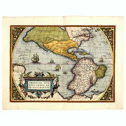
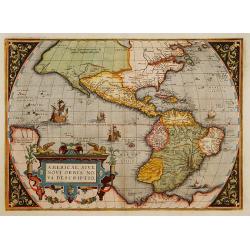
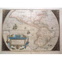
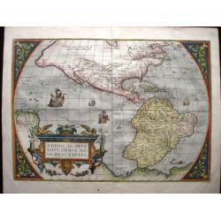
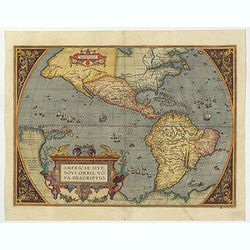
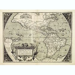
Americae Sive Novi Orbis, Nova Descriptio.
This is the second state of the first copperplate of Ortelius' map showing the western hemisphere, showing the prominent bulge in the South American coastline. An importa...
Date: Antwerp, 1573
Selling price: ????
Please login to see price!
Sold in 2014
Americae Sive Novi Orbis, Nova Descripto.
A finely engraved and beautiful map and one of the most recognised and influential maps of the Americas from the 16th century. This example is from an early state of the ...
Date: Antwerp, 1573
Selling price: ????
Please login to see price!
Sold in 2019
Mexico. & Cusco regni Peru in novo orbe caput.
From part one of the "Civitates", the only view in the entire work to depict cities of the New World. Shown here are the great cities of the Aztec and Inca cult...
Date: Antwerp, 1574
Selling price: ????
Please login to see price!
Sold in 2017

Americae Sive Novi Orbis, Nova Descriptio.
This is the second state of the first copperplate of Ortelius' map showing the western hemisphere, showing the prominent bulge in the South American coastline. An importa...
Date: Antwerp, 1574
Selling price: ????
Please login to see price!
Sold in 2015
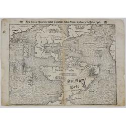
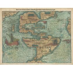
Die neüwen Inseln/ so hinder Hispanien gegen Orient bey dem land Indie ligen.
The earliest and one of the most important separate maps to show both Americas. Although it was not the first map to use “America” as a designation for the New World, it ...
Date: Basle, 1574
Selling price: ????
Please login to see price!
Sold in 2019
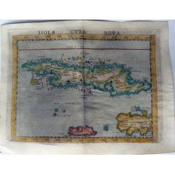
ISOLA CUBA NOVA.
One of the earliest separately published maps of Cuba. Also includes Jamaica and northwestern Hispaniola and the Cayman Islands. The map is elegantly designed and engrave...
Date: Venice, 1574
Selling price: ????
Please login to see price!
Sold in 2021
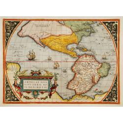
Americae Sive Novi Orbis, Nova Descriptio.
This is the third state of the first copperplate of Ortelius' map showing the western hemisphere, showing the prominent bulge in the South American coastline. An importan...
Date: Antwerp 1575
Selling price: ????
Please login to see price!
Sold
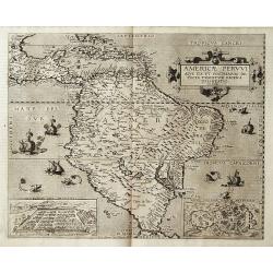
Americae Pervvi aqve ita vt postremvm detecta traditvr recens delineatio.
Map of Central and South America from the extremely rare first edition.. This map shows South America, part of Mexico, Caribbean and the southern tip of Florida. In lower...
Date: Antwerp 1578
Selling price: ????
Please login to see price!
Sold
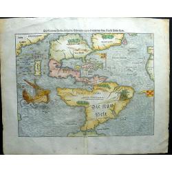
America. Die Neüwen Inseln so hinder Hispanien gegen Orient, bey dem Landt Indie ligen.
A very rare state of the earliest separate map to show both North and South America. One of the first maps also to include Japan, and the first to refer to "Mare Pac...
Date: Basel, 1578
Selling price: ????
Please login to see price!
Sold in 2018
Americae Sive Novi Orbis, Nova Descriptio.
This is the second copperplate of Ortelius' map showing the western hemisphere, showing the largest ships in the Pacific sailing eastward and the prominent bulge in the S...
Date: Antwerp 1579
Selling price: ????
Please login to see price!
Sold
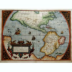
Americae Sive Novi Orbis, Nova Descriptio. . .
This is the second copperplate of Ortelius' map showing the western hemisphere, showing the largest ships in the Pacific sailing eastward and the prominent bulge in the S...
Date: Antwerp 1579
Selling price: ????
Please login to see price!
Sold in 2017
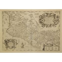
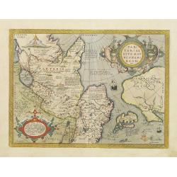
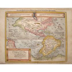
Hispaniae Novae sivae magnae, ...
This was the standard map of the area for a generation, copied by Quad, Hondius and De Bry. Even though Herrera (Spain's Royal Cosmographer) and Wytfliet worked 20 years ...
Date: Antwerp, 1579
Selling price: ????
Please login to see price!
Sold in 2011
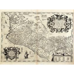
Hispaniae novae sivae magnae, recens et vera descriptio. 1579
Nice map of Mexico with the Pacific coastal line by A. Ortelius. With three beautiful cartouches and two sailing ship. From the 1579 Latin edition of 'Theatrum Orbis Terr...
Date: Antwerp, 1579
Selling price: ????
Please login to see price!
Sold in 2010
Americae sive Novi Orbis Nova Descriptio.
A derivative of Mercator's large map published the year before, this is the second plate of Ortelius's map of the Americas, with the ship in the Pacific sailing East ward...
Date: Antwerp, 1579
Selling price: ????
Please login to see price!
Sold in 2016
Hispaniae novae sive magnae recens et vera descriptio. 1579
This was the standard map of the area for a generation, copied by De Bry, Quad and Hondius. Even though Herrera (Spain's Royal Cosmographer) and Wytfliet worked 20 years ...
Date: Antwerp, 1579
Selling price: ????
Please login to see price!
Sold in 2016
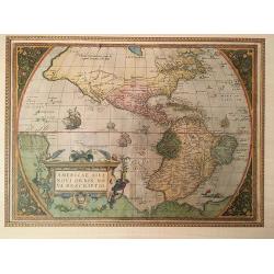
Americae Sive Novi Orbis Nova Descriptio.
Beautifully colored map of the Americas from the 1579 edition of Ortelius’ Theatrum Orbis Terrarum, the first modern atlas of the world. In this second edition, the orig...
Date: Antwerp, 1579
Selling price: ????
Please login to see price!
Sold in 2015
Americae sive Novi Orbis Nova Descriptio.
A rare miniature map of North and South America based on Ortelius' larger map, ornamented with two sailing ships and a delicate floral framing. This is the second edition...
Date: Antwerp, 1579
Selling price: ????
Please login to see price!
Sold in 2020
Americae Sive Novi Orbis, Nova Descriptio.
This is the third edition of Ortelius' map landmark map of the Americas showing the western hemisphere, and showing a prominent bulge in the South American coastline. An ...
Date: Antwerp, 1579
Selling price: ????
Please login to see price!
Sold in 2022
![[Native Americans meeting Vespucci]](/uploads/cache/11851-250x250.jpg)
[Native Americans meeting Vespucci]
"On recto an early representation of Vespucci meeting native Americans (92x142mm).From a French text edition of his ""Geographia"", that great co...
Date: Basle 1550-1580
Selling price: ????
Please login to see price!
Sold
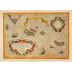
Açores Insulae.
The importance of the Azores at that time was connected with the observation of Columbus that compass variation (i.e. the difference between the real and the magnetic nor...
Date: Antwerp, 1580
Selling price: ????
Please login to see price!
Sold in 2015
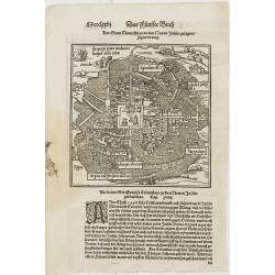
der Statt Themistitan in den newen Inseln gelegen / figurierung.
Plan of Mexico City (\"Der Statt Themistitan...\"). From his Cosmographia, that great compendium of Renaissance knowledge. An exciting print.Sebastian Münster w...
Date: Basle 1550-1580
Selling price: ????
Please login to see price!
Sold in 2008
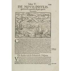
Liber V. De Novis insulis quomodo, quando & per quem illae inuentae sint.
Map of unspecified islands in the New World, printed area 105 x 160mm, set in a large page of text. From an Latin text edition of the Cosmography. One of the earliest obt...
Date: Basle, c. 1580
Selling price: ????
Please login to see price!
Sold in 2009
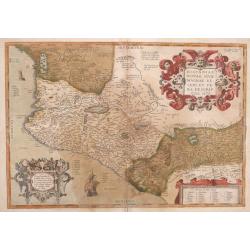
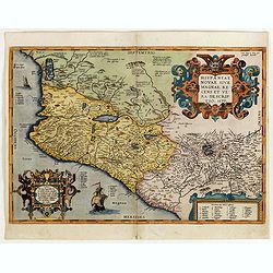
Hispaniae Novae Sivae Magnae, Recens et vera Descriptio.
This ornate edition is an important map of New Spain, and the forerunner for most maps of the early 17th century. It covers the Pacific coast from present-day Acapulco to...
Date: Antwerp 1580
Selling price: ????
Please login to see price!
Sold in 2014
![[UNTITLED] Indians of America and Africa.](/uploads/cache/92622-250x250.jpg)
[UNTITLED] Indians of America and Africa.
Rare representation of Indians. A set of 6 couples with titles below. Each couple with traditional clothing, some of the males with bow and arrow. After Abraham de Bruyn....
Date: Antwerp, 1581
Selling price: ????
Please login to see price!
Sold in 2013
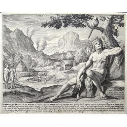
America, sive Bresilia. . .
print of America. By Jan Sadeler after Theodor Bernard.
Date: Amsterdam, ca 1581
Selling price: ????
Please login to see price!
Sold in 2018
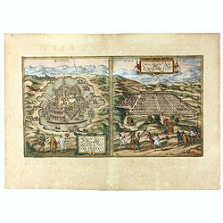
![Mexico, Regia et Celebris Hispaniae Novae Civitas ... [on sheet with] Cusco, Regni Peru in Novo Orbe Caput.](/uploads/cache/83281-250x250.jpg)
Mexico, Regia et Celebris Hispaniae Novae Civitas ... [on sheet with] Cusco, Regni Peru in Novo Orbe Caput.
An antique map with two bird's-eye views of Mexico City and Cusco (Peru). German text on verso by Braun & Hogenberg.
Date: Cologne, 1582
Selling price: ????
Please login to see price!
Sold in 2019
Brevis exactaq totius novi orbis eiusq insularum descriptio recens edita
Woodcut map of the Americas, which was published in three states. The first in Antwerp by Iuan Steelsio in 1554 in “La Historia General de las Indias”, written by the his...
Date: Antwerp, 1566, 1567 or 1583
Selling price: ????
Please login to see price!
Sold in 2023
Tartariae sive Magni Chami Regni typus.
Much of the information shown on this map relates to the travels of Marco Polo between 1275 and 1291 with later information gained from the Portuguese Jesuit missionaries...
Date: Antwerp 1584
Selling price: ????
Please login to see price!
Sold
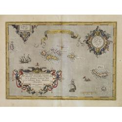
Açores Insulae.
First state. The importance of the Azores at that time was connected with the observation of Columbus that compass variation (i.e. the difference between the real and the...
Date: Antwerp, 1584
Selling price: ????
Please login to see price!
Sold in 2014
Açores Insulae. . .
Three cartouches of exceptional beauty decorate this artistic map. A beautifully engraved chart of the Azores based on Luis Teixeira's cartographic work with two ornate t...
Date: Antwerp, 1584
Selling price: ????
Please login to see price!
Sold in 2015
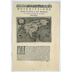
Descrittione dell' isola et terra di Santa Croce, overo Mondo Nuovo.
Porcacchi's map of North America, set in a page of text From "L'Isole piu famoso del mondo”. This is the second earliest obtainable map of North America, preceded on...
Date: Venice, 1572-1585
Selling price: ????
Please login to see price!
Sold in 2019
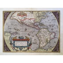
Americae Sive Novi Orbis.
This is the third state of the famous Ortelius map showing the western hemisphere without the prominent bulge in the South American coastline.
Date: Antwerp, 1587
Selling price: ????
Please login to see price!
Sold in 2016
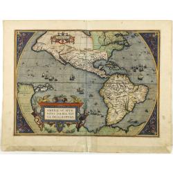
Americae sive novi orbis, nova descriptio.
In 1587, a new plate was engraved which appeared in editions from 1588 onwards. Of the three maps, this one is perhaps the most important. It is the most geographically a...
Date: Antwerp, 1587
Selling price: ????
Please login to see price!
Sold in 2018
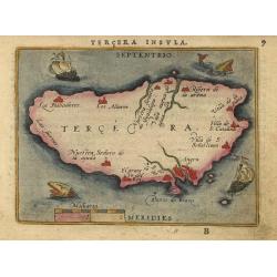
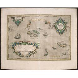
Tercera Insula
Nice miniature map showing the island and the important port of Angra. The map is beautifully engraved with stippled seas and two sailing ships and two tiny sea monsters.
Date: Antwerp, 1588
Selling price: ????
Please login to see price!
Sold
Americae Sive Novi Orbis, Nova Descriptio.
Third plate, state 1. In 1587, a new plate was engraved which appeared in editions from 1588 onward. Of the three maps, this one is perhaps the most important. Geographic...
Date: Anvers, 1588
Selling price: ????
Please login to see price!
Sold
![Americae sive Novi Orbis, Nova Descriptio [Spanish text edition]](/uploads/cache/199823-250x250.jpg)
Americae sive Novi Orbis, Nova Descriptio [Spanish text edition]
One of the most famous and decorative maps of America. In 1587, a new plate was engraved which appeared in editions from 1588 onwards. Of the three maps, this one is perh...
Date: Antwerp, (1587) 1588
Selling price: ????
Please login to see price!
Sold in 2011
Americae Sive Novi Orbis Nova Descriptio. Die newen inseln so hinder Hispaniam gegen Orient, bey dem landt Indie gelegen
Nicely colored map of North and South America. Two elongated oval cartouches across the top with gothic German text and a finely decorated title cartouche to the bottom l...
Date: Basle, Henri Petrie, 1588
Selling price: ????
Please login to see price!
Sold in 2013
