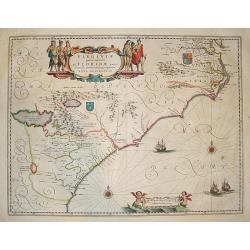
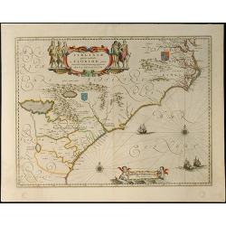
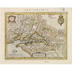
Browse Listings in America > North America > Virginia / Maryland / Carolina / Georgia
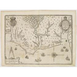
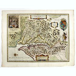
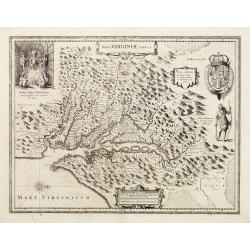
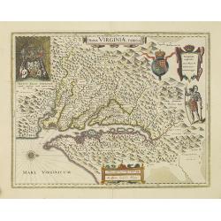
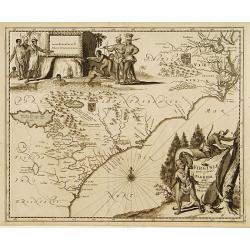
Americae pars, Nunc Virginia dicta, primum ab Anglis. . .
John White's map, elegantly designed and superbly engraved, revolutionized geographic knowledge of the region. Although White left the Chesapeake poorly explored, much of...
Date: Frankfurt, 1590
Selling price: ????
Please login to see price!
Sold

Wie die Weiber von Dafamonguepeuc.
Engraving depicting a native American woman of Dasamonguepeuc carrying a child, from Theodorus De Bry's Les Grands Voyages.
Date: Frankfurt, 1590
Selling price: ????
Please login to see price!
Sold in 2013
![[The Englishmen's arrival in Virginia with Roanoke Colony - Carolina Coastline] No title.](/uploads/cache/42117-250x250.jpg)
[The Englishmen's arrival in Virginia with Roanoke Colony - Carolina Coastline] No title.
Map showing the coast of Virginia with many islands just off the mainland, two Native territories, Secotan and Weapemeoc, and the Native community of Roanoak on an island...
Date: Frankfurt, c. 1590
Selling price: ????
Please login to see price!
Sold in 2018
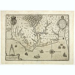
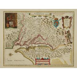
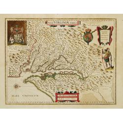
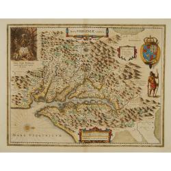
Americae pars, Nunc Virginia dicta, primum ab Anglis. . .
John White's map, elegantly designed and superbly engraved, revolutionized geographic knowledge of the region. Although White left the Chesapeake poorly explored, much of...
Date: Frankfurt, 1590
Selling price: ????
Please login to see price!
Sold in 2019
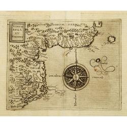
Norumbega et Virginia.
Rare sixteenth century map: It shows the east coast of North America from the Outer Banks of present day Carolina to Canada is depicted at a period just before a number o...
Date: Cologne 1598
Selling price: ????
Please login to see price!
Sold
![[Native Virginian women sitting around a fire].](/uploads/cache/39419-250x250.jpg)
[Native Virginian women sitting around a fire].
A print of (mostly) native Virginian women sitting around a large campfire, one with plenty of flame and smoke.Theodore De Bry (1528-1598), was born in Liege in modern da...
Date: Frankfurt, 1607
Selling price: ????
Please login to see price!
Sold in 2018
![[The town of Pomeiock].](/uploads/cache/39420-250x250.jpg)
[The town of Pomeiock].
Pomeiock was a village with a strong palisade all round, and a very narrow entrance, which was typical of that region.
Date: Frankfurt, 1607
Selling price: ????
Please login to see price!
Sold in 2017
![[The town of Pomeiock].](/uploads/cache/42276-250x250.jpg)
[The town of Pomeiock].
Pomeiock was a village with a strong palisade all round, and a very narrow entrance, which was typical of that region. Inside were a few houses in which only the chief an...
Date: Frankfurt, 1607
Selling price: ????
Please login to see price!
Sold in 2018
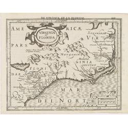
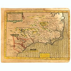
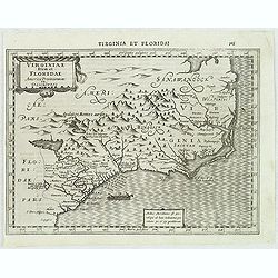
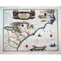
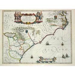
Virginia et Florida.
Excellent example of Mercator's miniature map of Colonial America, south to named St. Augustine, north past Chesapeake Bay. Early reference to 'Apalacci' Mountains, showi...
Date: Amsterdam, 1608
Selling price: ????
Please login to see price!
Sold in 2013
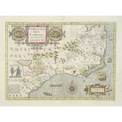
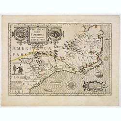
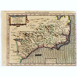
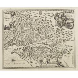
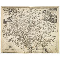
Virginiae Item et Floridae Americae Provinciarum.nova Descriptio.
An attractive, detailed and early map of the Southeast from the rare Cloppenburg edition slightly larger format and more scarce edition of the Mercator/Hondius "Atla...
Date: Amsterdam, Cloppenburgh, 1608
Selling price: ????
Please login to see price!
Sold in 2016
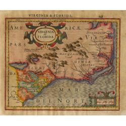
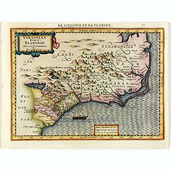
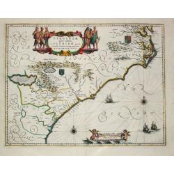
Virginia et Florida
Nice small map based on the Hondius' folio map of the same name. Based on John White's Virginia and Jacques le Moyne's Florida as interpreted by Theodore de Bry. Numerous...
Date: Amsterdam, 1609
Selling price: ????
Please login to see price!
Sold in 2011
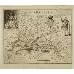
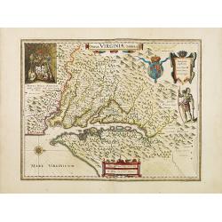
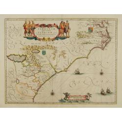
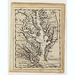
Virginia.
One of the most important printed maps of America ever produced and certainly one of the greatest influence. It became the prototype for the area for half a century. Firs...
Date: Frankfurt 1627
Selling price: ????
Please login to see price!
Sold
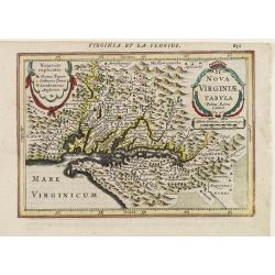
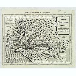
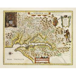
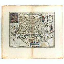
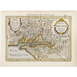
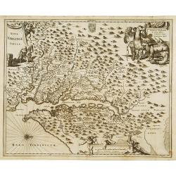
Nova Virginiae Tabula.
The map is based on the first state of Smith's map, 1612, and is slightly larger and more expertly engraved. In 1629 the Hondius plate was purchased by Blaeu who deleted ...
Date: Amsterdam 1618-1629
Selling price: ????
Please login to see price!
Sold
Virginiae item et Floridae.
Cummings describes it as one of the most beautifully executed maps ever made of the Southeast. In detail and in general conception it surpasses all earlier maps of the re...
Date: Amsterdam, 1630
Selling price: ????
Please login to see price!
Sold in 2013
Virginiae item et Floridae.
"Cummings describes it as ""one of the most beautifully executed maps ever made of the Southeast. In detail and in general conception it surpasses all earl...
Date: Amsterdam 1630
Selling price: ????
Please login to see price!
Sold
Virginiae item et Floridae..
Cummings describes it as one of the most beautifully executed maps ever made of the Southeast. In detail and in general conception it surpasses all earlier maps of the re...
Date: Amsterdam, 1630
Selling price: ????
Please login to see price!
Sold in 2016
Virginiae item et Floridae..
Cummings describes it as one of the most beautifully executed maps ever made of the Southeast. In detail and in general conception it surpasses all earlier maps of the re...
Date: Amsterdam, 1630
Selling price: ????
Please login to see price!
Sold in 2014
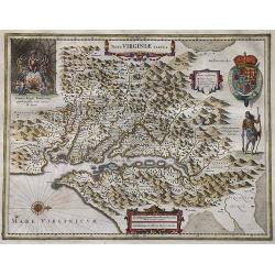
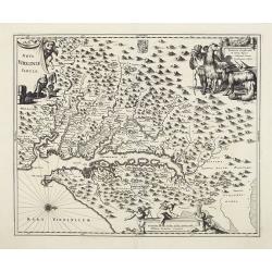
Nova Virginiae Tabula.
The map is based on the first state of Smith's map, 1612, and is slightly larger and more expertly engraved.The map is, in part, famous for its depiction, upper left, of ...
Date: Amsterdam, 1630
Selling price: ????
Please login to see price!
Sold in 2016
Virginiae item et Floridae.
From the rare French text edition of Mercator's Atlas Minor. From the first of the so-called Cloppenburg edition with new engraved maps in a larger format. The map extend...
Date: Amsterdam, 1630
Selling price: ????
Please login to see price!
Sold in 2017
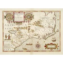
Virginiae item et Floridae Americae Provinciarum nova Descriptio.
Map of the Carolinas and parts of Virginia and Georgia. The map extends from St. Augustine in the south to just north of Chesepioock Sinus in the north and to the Allegha...
Date: Amsterdam, 1630
Selling price: ????
Please login to see price!
Sold in 2022
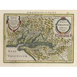
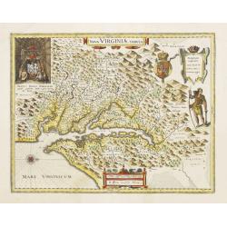
Nova Virginiae Tabula.
Janssonius' derivative of John Smith's landmark map of the Chesapeake of which only three other copies have been recorded (Verner). The map is the only regional map of Am...
Date: Amsterdam 1628-1631
Selling price: ????
Please login to see price!
Sold
Nova Virginiae Tabula
NO TEXT ON VERSO: From the rare Atlantis Appendix of 1630 and 1631.One of the most important maps of the Chesapeake Bay region, credited with disseminating knowledge of t...
Date: Amsterdam ca. 1630-1631
Selling price: ????
Please login to see price!
Sold
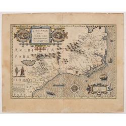
Virginiae Item et Floridae Americae Provinciarum.nova Descriptio.
An attractive, detailed and early map of the Southeast from the rare Cloppenburg edition slightly larger format and more scarce edition of the Mercator/Hondius "Atla...
Date: Amsterdam, 1632
Selling price: ????
Please login to see price!
Sold in 2012
Nova Virginiae Tabula. . .
An attractive, detailed and early map of the Chesapeake region from the rare Cloppenburg edition slightly larger format and more scarce edition of the Mercator/Hondius &q...
Date: Amsterdam, 1632
Selling price: ????
Please login to see price!
Sold in 2012
![[The French reach Port Royal].](/uploads/cache/39919-250x250.jpg)
[The French reach Port Royal].
Scarce print with a German text sheet. When the French arrived, they called it Portuus Regalis or Port Royal because of its size and beauty. There they brought in the sai...
Date: Frankfurt, M.Merian, 1633
Selling price: ????
Please login to see price!
Sold in 2018
![[The Chickahominy make peace with the English].](/uploads/cache/41102-250x250.jpg)
[The Chickahominy make peace with the English].
When friendly trade sprung up between Powhatan’s people and the English, a neighbouring tribe, known as the Chickahominy, sent two men with gifts to Thomas Dale as a to...
Date: Frankfurt, M.Merian, 1633
Selling price: ????
Please login to see price!
Sold in 2018
![[Ralph hamor visits Chief Powhaton].](/uploads/cache/41107-250x250.jpg)
[Ralph hamor visits Chief Powhaton].
After the successful marriage of John Rolf to Pocahontas, Thomas Dale thought he would like to marry the youngest of Powhatan’s daughters. He sent Hamor to the Indian v...
Date: Frankfurt, M.Merian, 1633
Selling price: ????
Please login to see price!
Sold in 2018
![[A truce between the Indians and the English].](/uploads/cache/41108-250x250.jpg)
[A truce between the Indians and the English].
Not having heard anything for some time from Powhatan, the English sailed again up the river with one hundred and fifty men, along with Powhatan’s daughter, to one of t...
Date: Frankfurt, M.Merian, 1633
Selling price: ????
Please login to see price!
Sold in 2018
![[Powhaton's daughter is abducted].](/uploads/cache/41109-250x250.jpg)
[Powhaton's daughter is abducted].
In 1613, Captain Argall managed to bribe some Indian friends of Pocahontas to visit his ship with them. When she was aboard, he kept her hostage and sailed back down rive...
Date: Frankfurt, M.Merian, 1633
Selling price: ????
Please login to see price!
Sold in 2018
![[John Smith is saved by Pocahontas].](/uploads/cache/41110-250x250.jpg)
[John Smith is saved by Pocahontas].
Within a few months of establishing the Jamestown colony in 1607, forty-six English had died from disease and starvation, so Smith went to try to obtain food from the Ind...
Date: Frankfurt, M.Merian, 1633
Selling price: ????
Please login to see price!
Sold in 2018
![[The massacre of Jamestown].](/uploads/cache/41118-250x250.jpg)
[The massacre of Jamestown].
A brutal and violent scene of native Indians massacring the new inhabitants of the recently established English colony of Jamestown in VA.In 1631 Johann Ludwig Gottfried,...
Date: Frankfurt, M.Merian, 1633
Selling price: ????
Please login to see price!
Sold in 2018
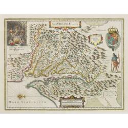
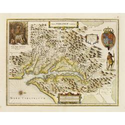
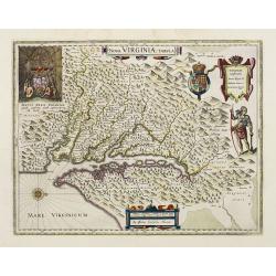
Nova Virginiae Tabula.
A decorative small version of John Smith's map of Chesapeake Bay region. It is the only regional map of North America to appear in the Atlas Minor. Engraved by Pieter van...
Date: Amsterdam 1634
Selling price: ????
Please login to see price!
Sold
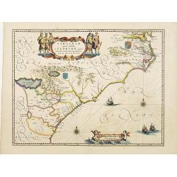
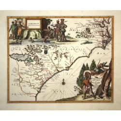
Virginiae Partis Australis, et Floridae Partis Orientalis.
This beautifully engraved map is based on the Mercator-Hondius work of 1606, with a significant number of geographic changes / improvements, particularly along the Caroli...
Date: Amsterdam, ca. 1635
Selling price: ????
Please login to see price!
Sold
Nova Virginiae Tabula.
The map is based on the first state of Smith's map, 1612, and is slightly larger and more expertly engraved. In 1629 the Hondius plate was purchased by Blaeu who deleted ...
Date: Amsterdam 1635
Selling price: ????
Please login to see price!
Sold
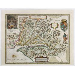
Nova Virginiae Tabula.
One of the most important maps of the Chesapeake Bay region, credited with disseminating knowledge of the English settlement in Virginia throughout Europe in the 17th cen...
Date: Amsterdam, ca. 1636
Selling price: ????
Please login to see price!
Sold
Nova Virginiae Tabula.
One of the most important maps of the Chesapeake Bay region, credited with disseminating knowledge of the English settlement in Virginia throughout Europe in the 17th cen...
Date: Amsterdam, ca. 1636
Selling price: ????
Please login to see price!
Sold in 2022
Nova Virginiae Tabula.
The map is based on the first state of Smith's map, 1612, and is slightly larger and more expertly engraved. In 1629 the Hondius plate was purchased by Blaeu who deleted ...
Date: Amsterdam, 1638
Selling price: ????
Please login to see price!
Sold
Virginiae Partis australis, et Floridae partis orientalis, interjacentiumqs regionum Nova Descriptio
Important map of the East Coast, from the Chesapeake Bay to Georgia with numerous early place names including Jamestown, Cape Fear, and Newport News. Two coat of arms ill...
Date: Amsterdam, 1639
Selling price: ????
Please login to see price!
Sold in 2016
Nova Virginiae Tabula.
The map is based on the first state of Smith's map, 1612, and is slightly larger and more expertly engraved. In 1629 the Hondius plate was purchased by Blaeu who deleted ...
Date: Amsterdam 1640
Selling price: ????
Please login to see price!
Sold
Virginiae Partis Australis, et Floridae Partis Orientalis.
Blaeu based this map on the Mercator-Hondius of 1606. A number of geographical improvements, however were incorporated, although two large fictions lakes accompanied by e...
Date: Amsterdam 1640
Selling price: ????
Please login to see price!
Sold

Virginiae Partis Australis, et Floridae Partis Orientalis.
Blaeu based this map on the Mercator-Hondius of 1606. A number of geographical improvements were incorporated, though two large fictional lakes, accompanied by explanator...
Date: Amsterdam, 1640
Selling price: ????
Please login to see price!
Sold in 2026
Nova Virginiae Tabula.
Blaeu's beautiful map of Virginia, Maryland and the Chesapeake Bay region on North America's eastern seaboard. It shows the discoveries in the area as detailed by John Sm...
Date: Amsterdam, ca 1640
Selling price: ????
Please login to see price!
Sold in 2022
Nova Virginia Tabula.
Early map of Virginia. Being Henricus Hondius' derivative of John Smith's highly important map of Virginia, 1612. Orientation west to top.Title in an Antwerp style cartou...
Date: 1641
Selling price: ????
Please login to see price!
Sold in 2019
Nova Virginiae Tabula.
The map is based on the first state of Smith's map, 1612, and is slightly larger and more expertly engraved. In 1629 the Hondius plate was purchased by Blaeu who deleted ...
Date: Amsterdam, 1642
Selling price: ????
Please login to see price!
Sold
Virginiae Partis australis, et Floridae Partis Orientalis, interjacentiumq, regionum Nova Descripti
Attractive map of the east coast of Virginia and Florida. Second state with small tail at left water-cherub. "One of the many elegantly engraved maps of the Eastern ...
Date: Amsterdam, 1643
Selling price: ????
Please login to see price!
Sold in 2009
Nova Virginiae Tabula.
The map is based on the first state of Smith's map, 1612, and is slightly larger and more expertly engraved. In 1629 the Hondius plate was purchased by Blaeu who deleted ...
Date: Amsterdam 1645
Selling price: ????
Please login to see price!
Sold
Nova Virginiae Tabula.
The map is based on the first state of Smith's map, 1612, and is slightly larger and more expertly engraved.The map is, in part, famous for its depiction, upper left, of ...
Date: Amsterdam 1647
Selling price: ????
Please login to see price!
Sold
Virginia.
Detailed miniature map of Virginia, from a German text edition of his Atlas Minor. Engraved by Petrus Kaerius.
Date: Amsterdam (1628) 1648
Selling price: ????
Please login to see price!
Sold
Nova Virginiae Tabula..
Detailed miniature map of Virginia, from a German text edition of his Atlas Minor. Engraved by Petrus Kaerius.
Date: Amsterdam (1628) 1648
Selling price: ????
Please login to see price!
Sold
Nova Virginiae Tabula.
The map is based on the first state of Smith's map, 1612, and is slightly larger and more expertly engraved. In 1629 the Hondius plate was purchased by Blaeu who deleted ...
Date: Amsterdam 1638-1649
Selling price: ????
Please login to see price!
Sold
Virginiae partis australis et Floridae paertis orientalis, interjacentiumq3 regionum Nova Descriptio.
Johannes Janssonius, the great rival of Willem Blaeu, was the son-in-law of Jodocus Hondius. Together with Jodocus' son Hendrick, he continued to publish the successive e...
Date: Amsterdam, 1647-1658
Selling price: ????
Please login to see price!
Sold
Virginiae partis australis et Floridae paertis orientalis, interjacentiumq regionum Nova Descriptio.
Johannes Janssonius, the great rival of Willem Blaeu, was the son-in-law of Jodocus Hondius. Together with Jodocus' son Hendrick, he continued to publish the successive e...
Date: Amsterdam, 1647-1658
Selling price: ????
Please login to see price!
Sold in 2017
Nova Virginiae Tabula.
The map is based on the first state of Smith's map, 1612, and is slightly larger and more expertly engraved. In 1629 the Hondius plate was purchased by Blaeu who deleted ...
Date: Amsterdam, 1658
Selling price: ????
Please login to see price!
Sold
Nova Virginia Tabula.
A beautifully engraved map, derived from the highly influential map by Captain John Smith in 1612, showing Chesapeake Bay and the surrounding area. The decoration of this...
Date: Amsterdam 1671
Selling price: ????
Please login to see price!
Sold
Virginiae partis australis, et Floridae partis orientalis..
A beautifully engraved map, derived from the highly influential maps by Mercator and later Blaeu. The decoration of this finely engraved map has two entirely new cartouch...
Date: Amsterdam 1671
Selling price: ????
Please login to see price!
Sold
Nova Virginia Tabula.
A beautifully engraved map, derived from the highly influential map by Captain John Smith in 1612, showing Chesapeake Bay and the surrounding area.The decoration of this ...
Date: Amsterdam, 1671
Selling price: ????
Please login to see price!
Sold
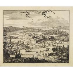
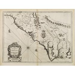
Arx Carolina.
View of the French settlement of Charles Fort, founded 1562 on Parris Island, Carolina, named after their king Charles IX.The garrison was captured three years later by t...
Date: Amsterdam, 1671
Selling price: ????
Please login to see price!
Sold
Nova Virginia Tabula.
A beautifully engraved map, derived from the highly influential map by Captain John Smith in 1612, showing Chesapeake Bay and the surrounding area.The decoration of this ...
Date: Amsterdam, 1671
Selling price: ????
Please login to see price!
Sold
Virginiae partis australis, et Floridae partis orientalis..
This striking map of the Southeast shows the French and English claims in the region marked with their respective coats of arms. The cartography in the southern part of t...
Date: London,1671
Selling price: ????
Please login to see price!
Sold in 2008
Nova Virginia Tabula.
A beautifully engraved map, derived from the highly influential map by Captain John Smith in 1612, showing Chesapeake Bay and the surrounding area.The decoration of this ...
Date: Amsterdam, 1671
Selling price: ????
Please login to see price!
Sold in 2013
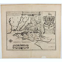
Nova terrae-Mariae tabula.
Double-page engraved map of Chesapeake Bay region, with west oriented at the top, the first printed map of Maryland. Perhaps prepared by Jerome Hawley and John Lewgerand ...
Date: London, ca 1671
Selling price: ????
Please login to see price!
Sold in 2023
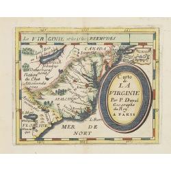
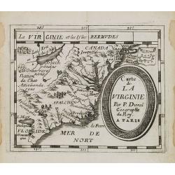
Carte de La Virginie.
Uncommon miniature map of Virginia, from Pierre Duval's La Geographie Universeille . It depicts the now defeated Swedish colony, and the inactive French claim of FLORIDE ...
Date: Paris, 1672
Selling price: ????
Please login to see price!
Sold in 2012
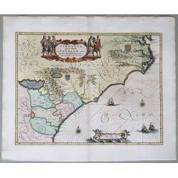
Virginiae partis australis, et Floridae partis orientalis. . .
A beautifully engraved map, derived from the highly influential maps by Mercator and later Blaeu, covering the area from the lower Chesapeake Bay to northern Florida. The...
Date: Amsterdam, 1673
Selling price: ????
Please login to see price!
Sold in 2015
Virginiae partis australis, et Floridae partis orientalis. . . Nova Descriptio.
A map of the East Coast of North America, showing the cost from Chesapeake Bay to the northern part of Florida. The full title in a cartouche at the top reads: Virginiae ...
Date: Amsterdam, 1673
Selling price: ????
Please login to see price!
Sold in 2020
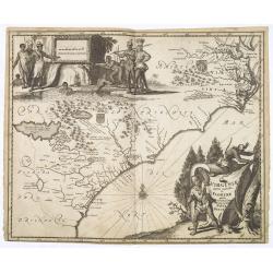
A new description of Carolina.
A wonderful map of Carolina. Incorporated into a 1676 reissue of Speed's 'Prospect Of The Most Famous Parts Of The World'. The map is (in)famous for its depiction of the ...
Date: London, 1676
Selling price: ????
Please login to see price!
Sold in 2021
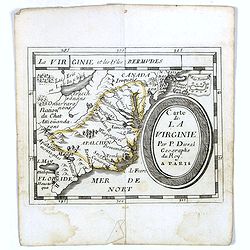
Carte de La Virginie.
Uncommon miniature map of Virginia from Pierre Duval\'s La Geographie Universeille dated 1676. It depicts the now defeated Swedish colony, and the inactive French claim o...
Date: Paris, 1676
Selling price: ????
Please login to see price!
Sold in 2008
Carte de La Virginie.
Uncommon miniature map of Virginia from Pierre Duval's La Geographie Universeille dated 1676. It depicts the now defeated Swedish colony, and the inactive French claim of...
Date: Paris, 1676
Selling price: ????
Please login to see price!
Sold
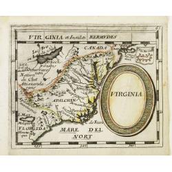
Virginia.
Uncommon derivate of this miniature map of Virginia, earlier published in Pierre Duval's La Geographie Universeille. It depicts the now defeated Swedish colony, and the i...
Date: Nuremberg 1678
Selling price: ????
Please login to see price!
Sold
Virginia.
Uncommon map of Virginia, printed by A. Godbid and J. Playford, for R. Scott. Included in "New systeme of the mathematicks: containing . . . II. Practical geometry. ...
Date: London, 1681
Selling price: ????
Please login to see price!
Sold
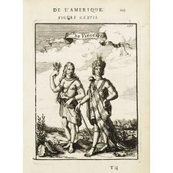
P.les de Virginie.
Attractive copper engraving, depicting a couple of native people of Florida.From the French text edition of Description d'Univers, 1683. by Allain Manneson Mallet (1630-1...
Date: Paris 1683
Selling price: ????
Please login to see price!
Sold
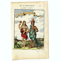
P.les de Virginie.
Attractive copper engraving, depicting a couple of native people of Virginia.From the French text edition of Description d'Univers, 1683. by Allain Manneson Mallet (1630-...
Date: Paris, 1683
Selling price: ????
Please login to see price!
Sold in 2025
![[ Pomeiocc, Virginia.]](/uploads/cache/36906-250x250.jpg)
[ Pomeiocc, Virginia.]
Attractive copper engraving, depicting a view of Pomeiocc, Virginia, with an inset of the interior of a Powhatan Lodge [ based on that of John Smith's map of Virginia].Fr...
Date: Paris, 1683
Selling price: ????
Please login to see price!
Sold in 2016
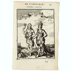
Ples. De Virginie.
A charming print depicting a male and female figure from the state of Virginia. Title in curtain draped at top. French text on verso.From the original 1683 text edition ...
Date: Paris, 1683
Selling price: ????
Please login to see price!
Sold in 2022
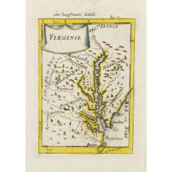
Virginie.
Charming miniature map of the Chesapeake Bay region locating the colony at Jamestown and the village of Pomejok.Several Indian tribes named including Powhatan. Title in c...
Date: Franckfurt 1684
Selling price: ????
Please login to see price!
Sold
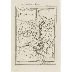
Virginie.
Charming miniature map of the Chesapeake Bay region locating the colony at Jamestown and the village of Pomejok.Several Indian tribes named including Powhatan. Title in c...
Date: Frankfurt, 1684
Selling price: ????
Please login to see price!
Sold in 2008
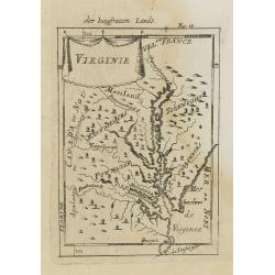
Virginie.
Charming miniature map of the Chesapeake Bay region locating the colony at Jamestown and the village of Pomejok.Several Indian tribes named including Powhatan. Title in c...
Date: Frankfurt, 1684
Selling price: ????
Please login to see price!
Sold in 2008
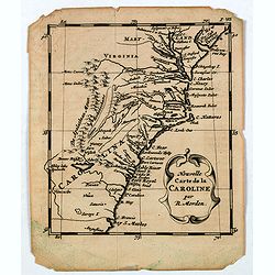
Nouvelle Carte de la CAROLINE.
A scarce small map of Carolina by the English cartographer Robert Morden. Scarce early edition of Abraham Wofgang's Amsterdam edition of Morden's map of the Carolina, one...
Date: Amsterdam, 1688
Selling price: ????
Please login to see price!
Sold in 2020
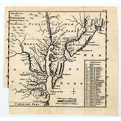
Nouvelle Carte de la Pensylvanie Maryland Virginia et Nouvelle Jarsey.
A scarce edition of this early map of the east coast region centered on New York and the Chesapeake and Delaware, from Abraham Wolfgang's L'Amerique Angloise, ou Descript...
Date: Amsterdam, 1688
Selling price: ????
Please login to see price!
Sold in 2020
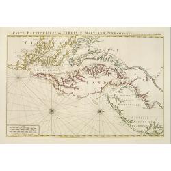
Carte Particuliere de Virginie, Maryland, Pennsilvanie, La Nouvelle Jarsey. Orient et Occidentale.
Large scale, decorative map centered on Maryland and the Chesapeake Bay. Shown is an area from Staten Island in New York southward to Carratuck Inlet in North Carolina wi...
Date: Amsterdam c. 1700
Selling price: ????
Please login to see price!
Sold
