Browse Listings in America > North America > Great Lakes / Philadelphia
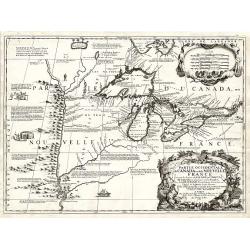
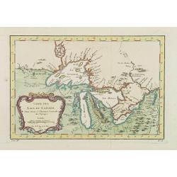
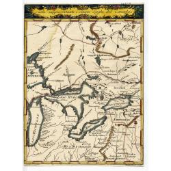
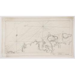
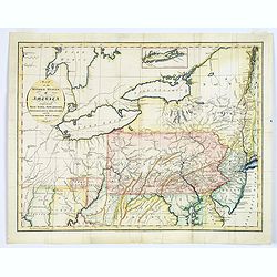
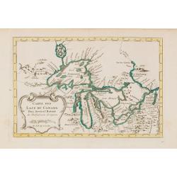
Partie Occidentale du Canada ou de la Nouvelle France...
A very rare map of the Great Lakes by Coronelli / Nolin and one of the most beautiful, acquirable works to focus on the region. As Tooley states, ?it was the best represe...
Date: Paris, 1688
Selling price: ????
Please login to see price!
Sold
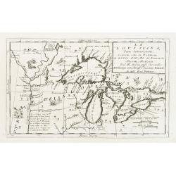
La Lovisiana, Parte Settentrionalle, Scoperta sotto la Protettione di Luigi XIV, Rè di Francia..
One of the most important maps of the Great Lakes and Upper Mississippi, based upon reports of La Salle, Hennepin, Marquette, Jolliet and other French Jesuits who were ac...
Date: Venice 1690
Selling price: ????
Please login to see price!
Sold
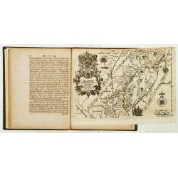
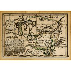
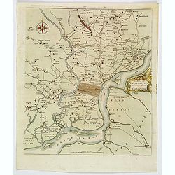
Nova Svecia hodie dicta Pensylvania.
Very rare map shows the location of Swedish settlements on the Delaware River.Prepared by Peter Lindström in 1655, who made a map titled Nova Svecia, anno 1654 och 1655,...
Date: Stockholm 1702
Selling price: ????
Please login to see price!
Sold
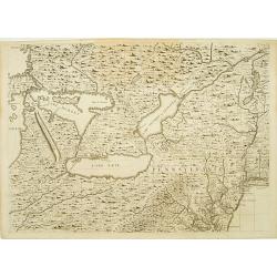
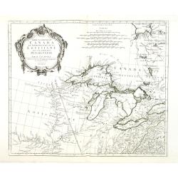
Carte du Canada ou de la Nouvelle France. . .
First issued by Guillaume Delisle in 1703, this important, detailed map provides the most accurate rendering of the Great Lakes of the time, with the lakes fully enclosed...
Date: Amsterdam, c.1730
Selling price: ????
Please login to see price!
Sold in 2019
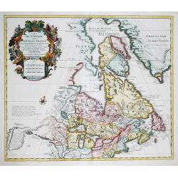
Delineatis Pennsylvaniae et Caesereae nov. Occidebt seu West Niersey in America.
An extremely rare map of Pensylvania and New Jersey engraved by Jonas Silfverlong. Published in a publication by Tobias Biorck titled Dissertatio Gradualis, de Plantation...
Date: Upsula 1731
Selling price: ????
Please login to see price!
Sold
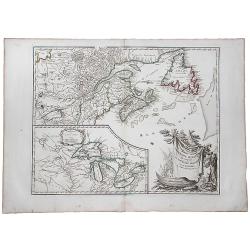
Sheet 6 of 20: The Great Lakes and New Jersey.
One sheet of H.Popple's twenty-sheet survey of North America, in a first state, the first large-scale map of the British colonies in America. Featuring the Great Lakes in...
Date: London 1733-1735
Selling price: ????
Please login to see price!
Sold
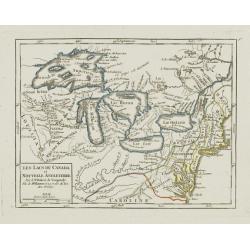
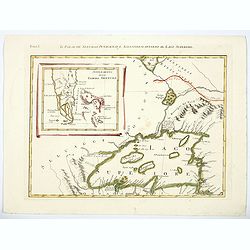
Les Lacs du Canada et Nouvelle Angleterre.
Charming small map showing the Great Lakes region from Superior to Ontario and including the northern part of Pennsylvania below Lake Erie, although the state is not name...
Date: Paris, later than 1749
Selling price: ????
Please login to see price!
Sold
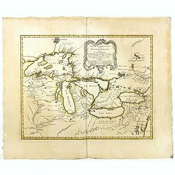
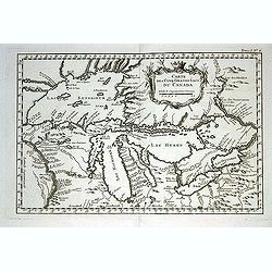
Partie Occidentale de la Nouvelle France ou des Canada.
A fine large-scale map derived from Bellin's landmark map of the Great Lakes which first appeared in Charlevoix's Histoire in 1744. The chart incorporates the work of Sie...
Date: Nuremberg, 1755
Selling price: ????
Please login to see price!
Sold in 2015
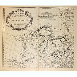
Canada Louisiane et Terres Angloises.
The northwest sheet of a four-sheet map featuring the Great Lakes and upper Mississippi River. Large, decorative cartouche designed by Gravelot. The map was based in part...
Date: Paris, 1755
Selling price: ????
Please login to see price!
Sold in 2012
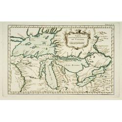
Partie Occidentale de la NOUVELLE FRANCE ou du CANADA.
A fine large-scale map derived from Bellin's landmark map of the Great Lakes which first appeared in Charlevoix's Histoire in 1744. However, Homann's publication is more ...
Date: Nuremberg, 1755
Selling price: ????
Please login to see price!
Sold in 2020
Partie Occidentale de la Nouvelle France ou de Canada.
An important and influential map of the Great Lakes region during the time of French colonial occupation. This map was originally engraved by Jacques Bellin in 1745, howe...
Date: Nuremberg, 1755
Selling price: ????
Please login to see price!
Sold in 2017
Partie Occidentale de la Nouvelle France ou des Canada.
A fine large-scale map derived from Bellin's landmark map of the Great Lakes which first appeared in Charlevoix's Histoire in 1744. However, Homann's publication is more ...
Date: Nuremberg 1755
Selling price: ????
Please login to see price!
Sold
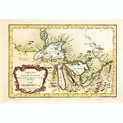
Carte Des Lacs Du Canada Pour sevir a l'Histoire Generale des Voyages.
Showing the all the Great Lakes in the traditional Bellin configuration. Jacques Nicolas Bellin (1703-1772) was one of the most important and proficient French cartograph...
Date: Paris, 1757
Selling price: ????
Please login to see price!
Sold in 2011
NEW YORK AND PENSILVANIA
Charming little map of the Great Lakes, showing also Maryland, New York, and Pennsylvania. From the Atlas Minimus Illustratus. Includes Philadelphia, Ft. du Quesne, Kuski...
Date: London, c.1760
Selling price: ????
Please login to see price!
Sold in 2009
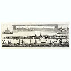
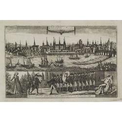
The East Prospect of the City of Philadelphia, in the Province of Pennsylvania.
This copper engraving view is based on the famous George Heap view, first published in c.1756. The print shows the city as a bustling river port of some importance and so...
Date: London, 1761
Selling price: ????
Please login to see price!
Sold in 2019
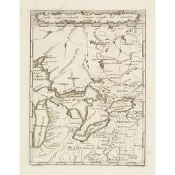
Carta Rappresentante I cinque Laghi del Canada.
Highly detailed map of the Great Lakes and contiguous regions, which appeared in Masi's "Il Gazzettiere Americano." Engraved by A.Scacciati.The map's nomenclatu...
Date: Livorno 1763
Selling price: ????
Please login to see price!
Sold
CARTA RAPPRESENTANTE I CINQUE LAGHI DEL CANADA
Rare and important Italian map showing the area of the Great Lakes. Published in "Il Gazzettiere Americano" 1763. Very detailed map of the area with many place...
Date: Livorno, 1763
Selling price: ????
Please login to see price!
Sold
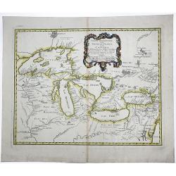
Carte des cinq Grands Lacs du Canada.
A good engraved map of the Great Lakes area, showing the imaginary islands of Philippeaux and Pontchartrain in Lake Superior. From l'Histoire générale des voyages .Bell...
Date: Paris, 1764
Selling price: ????
Please login to see price!
Sold in 2013
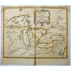
Carte des Cinq Grands Lacs du Canada.
This map shows the territories of all the 5 great lakes. The map shows Indian land, forts, missions, rivers and lakes, plus some trails and portages.The only issue of thi...
Date: Paris 1764
Selling price: ????
Please login to see price!
Sold
![[Detroit] La Rivière du Détroit Depuis le lac Sainte Claire jusqu'au Lac Erié.](/uploads/cache/17065-250x250.jpg)
[Detroit] La Rivière du Détroit Depuis le lac Sainte Claire jusqu'au Lac Erié.
This is the first separately printed map of Detroit, showing the village, fort, anchorages, islands and navigational hazards, with an inset of the fort with five lettered...
Date: Paris 1764
Selling price: ????
Please login to see price!
Sold
Carte Des Lacs Du Canada Pour sevir a l'Histoire Generale des Voyages.
Showing the all the Great Lakes in the traditional Bellin configuration. Jacques Nicolas Bellin (1703-1772) was one of the most important and proficient French cartograph...
Date: Paris, 1764
Selling price: ????
Please login to see price!
Sold in 2014
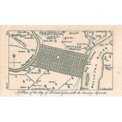
A Plan of the City of Philadelphia, with the Country Adjacent.
Early small plan of Philadelphia, published in "The World displayed; or, a curious collection of voyages and travels...". Quite detailed with roads and houses...
Date: London, 1767
Selling price: ????
Please login to see price!
Sold in 2010
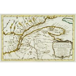
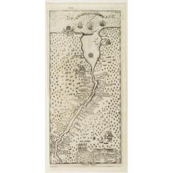
Carte du cours du Fleuve de St.Laurent..
Uncommon edition of this accurate map showing the lower St.Laurence. Second state.From Atlas Portatif pour servir a l'intelligence de l'Histoire Philosophique et Politiqu...
Date: Amsterdam 1773
Selling price: ????
Please login to see price!
Sold
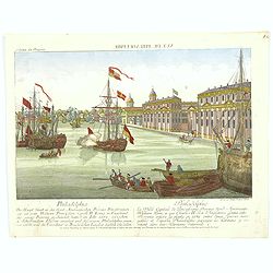
Vue de Philadelphie.
An attractive optical prints of Philadelphia, the capital of Pennsylvania, and the future fledgling nation's capital, during the Revolutionary war with Britain. A harbour...
Date: Augsburg, 1776
Selling price: ????
Please login to see price!
Sold in 2016
Partie Occidentale du Canada et Septentrionale de la Louisiane..
Fine copper engraved map of the Great Lakes region after d'Anville's, to whom Santini gives credit in the cartouche.The map extends from the upper Mississippi River valle...
Date: Venice, 1776
Selling price: ????
Please login to see price!
Sold in 2009
A Chart of New York Island & North River: East River, Passage Through Hell's Gate, Flushing Bay, Hampstead Bay ...... (Fragment Only)
This is a fragment of a very important, large chart. It was produced by Joseph Des Barres in London in 1777. The full map shows Long Island north shore from Eaton’s N...
Date: London, 1777
Selling price: ????
Please login to see price!
Sold in 2017

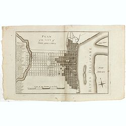
A plan of the City and Environs of Philadelphia. . .
The Lotter edition of Scull & Heap's seminal Philadelphia map, which map was first issued in 1752.Holmes' grid plan for the city is shown, situated between the rivers...
Date: Augsburg, 1777
A Map of Philadelphia and Parts Adjacent.
A nice example of the 1777 Revolutionary War edition of the Scull & Heap map of Philadelphia, published by the Gentleman's Magazine. The Scull & Heap map went thr...
Date: London, 1777
Selling price: ????
Please login to see price!
Sold in 2019
![LA PENSILVANIA, LA NUOVA YORK, IL JERSEY SETTENTRIO:le, CON LA PARTE OCCIDENTALE DEL CONNECTICUT. . . (Fogl. V.)[Lakes Huron, Erie, and Ontario]](/uploads/cache/83531-250x250.jpg)
LA PENSILVANIA, LA NUOVA YORK, IL JERSEY SETTENTRIO:le, CON LA PARTE OCCIDENTALE DEL CONNECTICUT. . . (Fogl. V.)[Lakes Huron, Erie, and Ontario]
A striking map of the north eastern section of the Italian edition of Mitchell's seminal map of North America, bounded by Lakes Huron & Oswego and Ohio in the west an...
Date: Venice, 1778
Selling price: ????
Please login to see price!
Sold in 2020
Il Paese de Selvaggi Outauacesi e Kilistinesi Intorno al Lago Superiore.
This is one sheet from Antonio Zatta's version of John Mitchell's epic map. The whole map was titled "Le Colonie Unite dell' America Settentrle" and was publish...
Date: Venice, 1780
Selling price: ????
Please login to see price!
Sold in 2020
Partie Occidentale du Canada et Septentrionale de la Louisiane..
Fine copper engraved map of the Great Lakes region after d'Anville's, to whom Santini gives credit in the cartouche.The map extends from the upper Mississippi River valle...
Date: Venice, 1776 - 1784
Selling price: ????
Please login to see price!
Sold in 2013
Map of the Middle States of America, comprehends New-York, New-Jersey, Pennsylvania, Delaware, and the Territory N.W. of Ohio.
An interesting map of the region of the United States extending from New Jersey to Indiana, and from northern New York to Maryland. Detail in the east is plentiful, with ...
Date: London, 1794
Selling price: ????
Please login to see price!
Sold in 2017
Plan of the city of Philadelphia.
Rare plan of Philadelphia with a lettered key to the important buildings (A. Congress Hall, B. State House C. City Hall, (. . .) W. Bank U.S. X. Bank Penn. Y. Bank N.A., ...
Date: Philadelphia, 1794
Selling price: ????
Please login to see price!
Sold in 2015
Partie de L'Amerique Septent. Qui comprend La Nouvelle France ou le Canada.
A decorative and highly detailed map of New England and part of Canada, extending east to Newfoundland, with a large inset map of the Great Lakes.One of the best large fo...
Date: Paris, 1797
Selling price: ????
Please login to see price!
Sold in 2019
Philadelphia in Amerika. / Bonaparte an der spitze seiner Pariser National Garde am 8 Novemb. 1799
Copper engraving with four scenes on one sheet. In upper part a view of Philadelphia. Published in "Allgemeine Welt-Chronik oder neue und wichtige Zeit-Geschichte al...
Date: Zittau, 1798-1800
Selling price: ????
Please login to see price!
Sold
![[ First Separate Map of Michigan Territory ] Geographical, statistical, and historical map of Michigan territory.](/uploads/cache/25931-250x250.jpg)
[ First Separate Map of Michigan Territory ] Geographical, statistical, and historical map of Michigan territory.
The map illustrates the Michigan Territory and the so-called "Indian Line" shortly after the Treaty of Chicago (1821), the third of three treaties with the Nati...
Date: Philadelphia, 1822
Selling price: ????
Please login to see price!
Sold in 2026
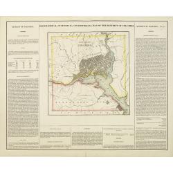
Geographical, statistical, and historical map of the district of Columbia.
Includes a detailed plan of Washington DC, Georgetown and Alexandria and a number of roads and rivers in the District. Muds Tavern is shown just outside the District on t...
Date: Philadelphia, 1822
Selling price: ????
Please login to see price!
Sold in 2010
Map of the Country Embracing the Route of the Expedition of 1823 commanded by Major SH Long.
Folding map originating from the rare book "Narrative of an Expedition to the Source of St. Peter's River : Lake Winnepeek, Lake of the Woods, &c., &c. Perfo...
Date: H.C.Carey and E. Lea, 1824
Selling price: ????
Please login to see price!
Sold in 2008
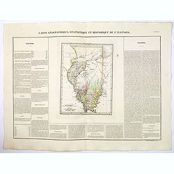
Carte Geographique, Statistique et Historique de Illinois.
A nice detailed map of the state of Illinois, from Buchon's Atlas Gégraphique Statistique, historique et chronologique des deux Ameriques et des isles adjacentes traduit...
Date: Paris, 1825
Selling price: ????
Please login to see price!
Sold in 2019
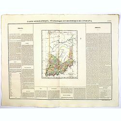
Carte Geographique, Statistique et Historique de L'Indiana.
A nice detailed map of the state of Indiana from Buchon's Atlas Gégraphique Statistique, historique et chronologique des deux Ameriques et des isles adjacentes traduit d...
Date: Paris, 1825
Selling price: ????
Please login to see price!
Sold in 2019
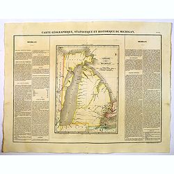
Carte Geographique, Statistique et Historique de Michigan.
A nice detailed map of Michigan, from Buchon's Atlas Gégraphique Statistique, historique et chronologique des deux Ameriques et des isles adjacentes traduit de l'atlas e...
Date: Paris, 1825
Selling price: ????
Please login to see price!
Sold in 2019
![[ State House in Philadelphia ].](/uploads/cache/27554-250x250.jpg)
[ State House in Philadelphia ].
Aquatint depicting the State House in Philadelphia engraved by Fumagalli. Plate N°42.From Giulio Ferrario's work Le Costume Ancien et Moderne ou Histoire du gouvernement...
Date: Milan, 1827
Selling price: ????
Please login to see price!
Sold in 2014
![[ View of the market place in Philadelphia. ].](/uploads/cache/27553-250x250.jpg)
[ View of the market place in Philadelphia. ].
Uncommon aquatint depicting a view of the market place in Philadelphia engraved by Fumagalli. Plate N°43.From Giulio Ferrario's work Le Costume Ancien et Moderne ou Hist...
Date: Milan, 1827
Selling price: ????
Please login to see price!
Sold in 2014
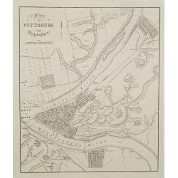
Plan von Pittsburg und umgebungen.
An detailed and rare view of Pittsburgh with a title in German, but details on map in English. From Bernhard zu Sachsen-Weimar-Eisenach: Reise durch Nord-Amerika.
Date: Weimar, 1828
Selling price: ????
Please login to see price!
Sold in 2008
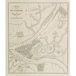
Plan von Pittsburg und umgebungen.
An detailed and rare view of Pittsburgh with a title in German, but details on map in English. From Bernhard zu Sachsen-Weimar-Eisenach: Reise durch Nord-Amerika.
Date: Weimar, 1828
Selling price: ????
Please login to see price!
Sold
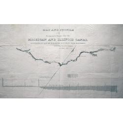
MAP AND PROFILE of the Proposed Route for the MICHIGAN AND ILLINOIS CANAL SURVEYED IN 1830 by W. B. GUION & H. BELIN CIVIL ENGINEERS reduced from the original drawing by J. R. IRWIN LIEUT. U.S.A.
Large scale plan of the Illinois Michigan Canal. Shows landmarks along its course. With the profile of Lake Michigan underneath the map. Unusual and interesting item!
Date: c1830
Selling price: ????
Please login to see price!
Sold in 2013
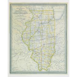
Mitchell's map of illinois exhibiting its internal improvements,
Detailed book illustration map of Illinois with railroads in red on crisp paper in blue print. Shows roads and stage roads. Very scarce map from Mitchell's Illinois in 18...
Date: Philadelphia 1837
Selling price: ????
Please login to see price!
Sold

Cutoff-River - Branch of the Wabash.
Original aquatint engraving for Travels in the Interior of North America between 1832-34 . Engraved by L.Weber. The finest work on American Indian life and the American F...
Date: London / Paris / Coblenz, 1839
Selling price: ????
Please login to see price!
Sold in 2009
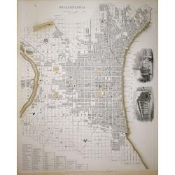
Philadelphia SDUK
A highly detailed mid-19th century plan of the city of Philadelphia by the Society for the Diffusion of Useful Knowledge.It depicts the entire city in remarkable detail, ...
Date: London, 1840
Selling price: ????
Please login to see price!
Sold in 2018
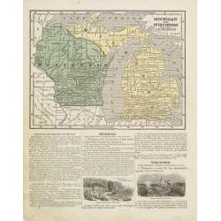
Michigan and Wisconsin
Map of Michigan and Wisconsin. Page 35/36 from Sidney E. Morse's: System of Geography for the use of schools , published by Harper and brothers, 329 Pearl Street, New Yor...
Date: New York 1855
Selling price: ????
Please login to see price!
Sold in 2011
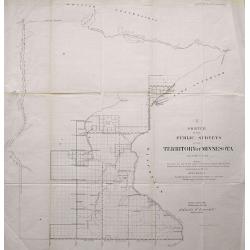
LOT OF 2: SKETCH OF THE PUBLIC SURVEYS IN THE TERRITORY OF MINNESOTA & SKETCH OF THE PUBLIC SURVEYS IN WISCONSIN AND TERRITORY OF MINNESOTA
Pair of lithographed maps of Minnesota and Wisconsin showing the Township boundaries for 1856. Included are rivers and towns.
Date: 1856
Selling price: ????
Please login to see price!
Sold in 2013
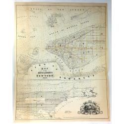
Map of the City & County of New York.
Detailed lithograph plan in two joined parts. The upper map details lower Manhattan up to 39th Street, and the lower map continuing the chart up to King's Bridge. There a...
Date: New York, 1858
Selling price: ????
Please login to see price!
Sold in 2017
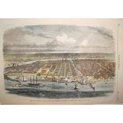
The City of Chicago, Illinois, Where the Republican Convention will Meet on May 16, 1860.
A handsome woodcut pre-great-fire view of Chicago. The work depicts the city as seen in the late 1850s and centers on the Chicago River.Numerous sailing and steam vessels...
Date: New York, 1860
Selling price: ????
Please login to see price!
Sold

Chicago in 1820.
A fascinating steel engraving of early frontier Chicago, adapted from a sketch done by H. R. Schoolcroft. The view depicts indigenous Americans canooing on Lake Michigan ...
Date: Washington DC, ca 1860
Selling price: ????
Please login to see price!
Sold
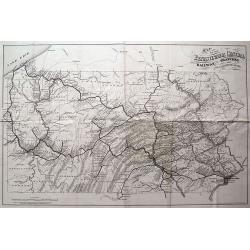
MAP OF THE PENNSYLVANIA CENTRAL RAILWAY, BRANCHES AND CONNECTING LINES.
Rare and interesting railroad map, showing the routes and stops from Philadelphia to Erie, including Pittsburgh. Very detailed with a lot of topographical information.
Date: Washington D.C., 1871
Selling price: ????
Please login to see price!
Sold in 2013
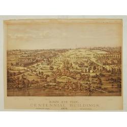
Bird's eye view, Centennial buildings.
Overview of the grounds of the 1876 International Exhibition Worldexpo in Philadelphia. The centennial exhibition took place to celibrate the 100 year eccistance of the R...
Date: Philadelphia 1876
Selling price: ????
Please login to see price!
Sold
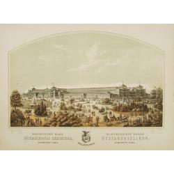
Machinery Hall - International Exhibition Fairmount Park
Very fine depiction of Machinery Hal at the 1876 International World exhibition in Philadelphia. The building was 1402 feet wide and used 14 acres. The centennial exhibit...
Date: Philadelphia 1876
Selling price: ????
Please login to see price!
Sold in 2008
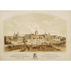
Argicultural Hall - International Exhibition Fairmount Park
A very fine depiction of Agricultural Hal at the 1876 International World exhibition in Philadelphia. The building was 826 feet wide and used 10.15 acres. The centennial ...
Date: Philadelphia, 1876
Selling price: ????
Please login to see price!
Sold in 2008
Main Building - International Exhibition Fairmount Park
Very fine depiction of Memorial Hal at the 1876 International World exhibition in Philadelphia. The building was 1880 feet wide and used 21.47 acres. The centennial exhib...
Date: Philadelphia 1876
Selling price: ????
Please login to see price!
Sold in 2008

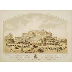
Memorial Hall - International Exhibition Fairmount Park
Very fine depiction of Memorial Hal at the 1876 International World exhibition in Philadelphia. The building was 365 feet wide and used 1.5 acres. The centennial exhibiti...
Date: Philadelphia 1876
Selling price: ????
Please login to see price!
Sold in 2008
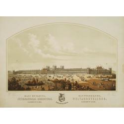
Horticultural Hall-International Exhibition Fairmount Park
Very fine depiction of Horticultural Hal at the 1876 International World exhibition in Philadelphia. The building was 360 feet wide and used 1.5 acres. The centennial exh...
Date: Philadelphia 1876
Selling price: ????
Please login to see price!
Sold in 2008
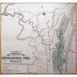
Map Issued by H.C. Frick & Co., Manufacturers Connellsville Coke.
Scarce large-scale map of the Connellsville coal vein by the H.C. Frick Coke Company. Locates ovens, towns, railroads, roads, creeks, etc. We could not locate a copy of ...
Date: Pittsburgh, 1880
Selling price: ????
Please login to see price!
Sold in 2013
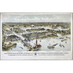
Grand Birds-Eye View of the Grounds and Buildings of the Great Columbian Exposition at Chicago, Illinois, 1892-3.
Lithography after a watercolor by C. Graham created as part of a portfolio for the World's Columbian Exposition (also known as the Chicago World's Fair) was a world's fai...
Date: New York, 1892
Selling price: ????
Please login to see price!
Sold in 2023
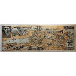
Bird's Eye View of the Tourists' Ideal Route from Niagara to the Sea.
A terrific "bird's eye view" of the Tourists' Ideal Route from Niagara to the Sea - ca. 1895. The maker is unknown, map shows from Nova Scotia to St Louis, and ...
Date: Buffalo, ca. 1895
Selling price: ????
Please login to see price!
Sold in 2018
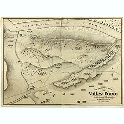
Topographic view of Valley Forge. During the Encompment of Washington's Army in the winter of 1777-78.
Fine and rare topographical view of Valley Forge, showing the area at the time of Washington's Encampment in December 1777 and January 1778. A reduced sized copy of the o...
Date: Philadelphia, 1911
Selling price: ????
Please login to see price!
Sold in 2020
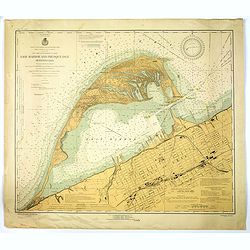
Erie Harbor and Presque Isle, Pennsylvania.
A US nautical chart of Erie Harbour and Presque Island in Pennsylvania - an eight updated edition (1924) to an original survey first undertaken in 1901 of the northern an...
Date: United States, 1924
Selling price: ????
Please login to see price!
Sold in 2021
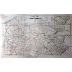
Steam Railroad Map of Pennsylvania.
A huge map, Issued by the Public Service Commission in 1929, by J. W. Clement Co., Matthews-Northrup Works, Buffalo, N. Y. This large folding map is the late twenties ver...
Date: Buffalo, 1929
Selling price: ????
Please login to see price!
Sold in 2017
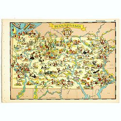
Pennsylvania.
Pictorial map of Pennsylvania, from the famous illustrator, Ruth Taylor White and published in "Our USA: A Gay Geography".Ruth Taylor White was among the most p...
Date: Boston, Little, Brown and Company, 1935
Selling price: ????
Please login to see price!
Sold in 2018
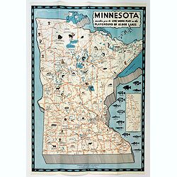
Minnesota invites you to Live-Work-Play in the Playground of 10,000 Lakes.
An attractive three color pictographic map of Minnesota, that folds down to a pamphlet, with numerous color and black and white illustrations on the verso. On the map, sm...
Date: Saint Paul, 1935
Selling price: ????
Please login to see price!
Sold in 2020
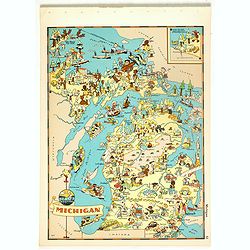
Michigan.
Pictorial map of Michigan, from the famous illustrator, Ruth Taylor White and published in "Our USA: A Gay Geography".Ruth Taylor White was among the most proli...
Date: Boston, Little, Brown and Company, 1935
Selling price: ????
Please login to see price!
Sold in 2018
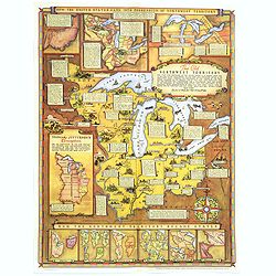
Historical Map of the Old Northwest Territory.
A large, folding lithographic map of the "Old Northwest Territory" in the time of Thomas Jefferson. This map seems to cover the states of Illinois, Indiana, Ohi...
Date: Ohio, ca. 1940
Selling price: ????
Please login to see price!
Sold in 2016
A Map of Downtown Chicago.
Silk map of Chicago’s Loop issued to celebrate the 100th anniversary of Marshall Field & Company.Though it nominally functions as a map of Chicago’s downtown, the...
Date: United-states, 1952
Selling price: ????
Please login to see price!
Sold in 2021
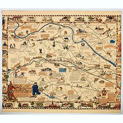
The Main Line. A Historical Map of Ye Outlying Regions . . .
A pictorial map depicting the geography, history and landmarks of the Main Line, the informal name for a group of western suburbs of Philadelphia, Pennsylvania. The area ...
Date: Philadelphia, 1975
Selling price: ????
Please login to see price!
Sold in 2020
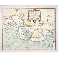
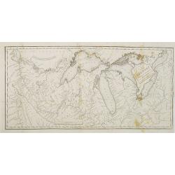
Carte des Lacs du Canada..
Scarce edition of this accurate map showing the all the Great Lakes in the traditional Bellin configuration.Kershaw does not mention this state with in lower right corner...
Date: Amsterdam, 1773.
Selling price: ????
Please login to see price!
Sold in 2014
