Browse Listings in America > North America > Indiana / Ohio / Kentucky / Georgia / Alabama
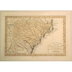
Carte de la Caroline et Georgie.
Fine hand-colored Bellin atlas map of the Southern States Georgia and Carolina from Curriluk Pass to Kekil Island. Out of "Atlas Portalif ". A plain title carto...
Date: Paris, 1773
Selling price: ????
Please login to see price!
Sold in 2020
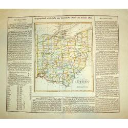
OHIO (Geographisch - statistische und historische Charte de Staates Ohio)
From the rare German edition of Carey and Lea?s, A Complete Historical, Chronological, and Geographical American Atlas, an early and impressive map of Ohio bordered with ...
Date: London and Weimar, 1825
Selling price: ????
Please login to see price!
Sold
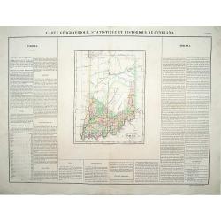
Carte Géographique .. Indiana.
\"Detailed map of Indiana. From J.A. Buchon, \"\"Atlas Gégraphique Statistique, historique et chronologique des deux Ameriques et des isles adjacentes; tra...
Date: Paris 1825
Selling price: ????
Please login to see price!
Sold
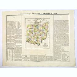
Carte Geographique, Statistique et Historique de L'Ohio.
A nice detailed map of the state of Ohio from Buchon's Atlas Gégraphique Statistique, historique et chronologique des deux Ameriques et des isles adjacentes traduit de l'...
Date: Paris, 1825
Selling price: ????
Please login to see price!
Sold in 2022
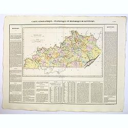
Carte Geographique, Statistique et Historique du Kentucky.
A nice detailed map of the state of Kentucky from Buchon's Atlas Gégraphique Statistique, historique et chronologique des deux Ameriques et des isles adjacentes traduit d...
Date: Paris, 1825
Selling price: ????
Please login to see price!
Sold in 2021
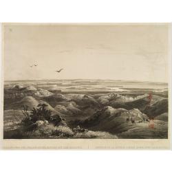
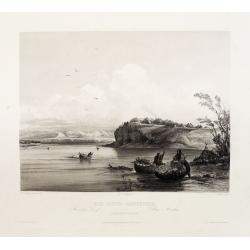
Réunion de la riviere Pierre Jaune avec le Missouri.
Original aquatint engraving after Karl Bodmer. Engraved by Salethé and printed by Bougeard.Karl Bodmer was engaged by Prince Maximilian to provide a record of his travels...
Date: Paris, 1834
Selling price: ????
Please login to see price!
Sold in 2019
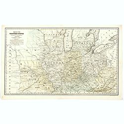
Map of the Western States designed to accompany Smith's Geography for Schools.
A detailed map of the American Midwest, published before the formation of Minnesota. It depicts individual counties, towns, roads, rivers, mountains, etc. Worth noting is...
Date: Chicago, 1839
Selling price: ????
Please login to see price!
Sold in 2020
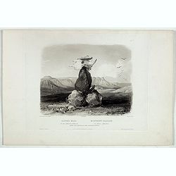
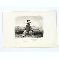
Magic Pile erected by the Assiniboin Indians.
This evocative and deeply spiritual engraving by Bodmer shows a cairn (human made stack, or pile of stones, rocks) topped with the skull of a buffalo, made by the Assinib...
Date: Pars, Coblenz, London, 1839
Selling price: ????
Please login to see price!
Sold in 2019
Magic Pile erected by the Assiniboin Indians.
This evocative and deeply spiritual engraving by Bodmer shows a cairn (human made stack, or pile of stones, rocks) topped with the skull of a buffalo, made by the Assinib...
Date: Pars, Coblenz, London, 1839
Selling price: ????
Please login to see price!
Sold in 2017
Mih-Tutta-Hangkusch a Mandan Village.
Original aquatint engraving for Travels in the Interior of North America between 1832-34 . Engraved by Lucas Weber. The finest work on American Indian life and the Americ...
Date: London/Paris/Coblenz, 1839
Selling price: ????
Please login to see price!
Sold
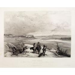
Fort Clark on the Missouri (February 1834)
Original aquatint engraving for Travels in the Interior of North America between 1832-34 . Engraved by Lucas Weber. The finest work on American Indian life and the Americ...
Date: London/Paris/Coblenz, 1839
Selling price: ????
Please login to see price!
Sold

Cave in Rock- view on the Ohio.
Original aquatint engraving for Travels in the Interior of North America between 1832-34 . Engraved by Lucas Weber. The finest work on American Indian life and the Americ...
Date: London/Paris/Coblenz, 1839
Selling price: ????
Please login to see price!
Sold in 2020
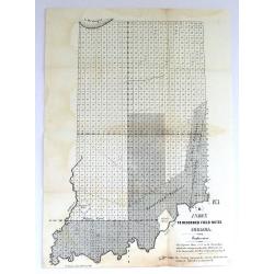
Three Early Government Survey Maps of Indiana.
Three of the earliest obtainable government survey maps of Indiana. 1) No. 1, R,” Index to Recorded Field Notes, Indiana”. Maker: General Land Office. Washington, 1849. 2...
Date: Washington, 1845-1849
Selling price: ????
Please login to see price!
Sold in 2019
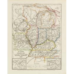
Die Staaten von Missouri, Illinois, Indiana, Ohio, Kentucky.
Detailed map of Missouri, Illinois, Indiana, Ohio, Kentucky and Tennessee with numerous physical and political features including mines, settlements, trails/roads, forts ...
Date: Hildburghausen/ Philadelphia 1850
Selling price: ????
Please login to see price!
Sold
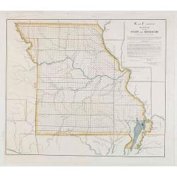
E and F (combined) Diagram of the State of Missouri.
Detailed land map of the state of Missouri, prepared by John G. Clark, William Dunn, William Shields and Aaron Snider and published by the Office of the surveyor general.
Date: Washington, 1852
Selling price: ????
Please login to see price!
Sold in 2021
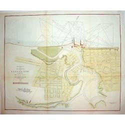
Survey of the Harbor of Cleveland Ohio..
An interesting and finely executed mid 19th century harbour survey and town plan of Cleveland. This lithographic work details the Cuyahoga River and topography of the cit...
Date: New York, ca 1853
Selling price: ????
Please login to see price!
Sold
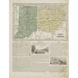
Ohio and Indiana.
Map of Ohio and Indiana. On verso a map of Iowa, Illinois and Missouri. From Sidney E. Morse''s: System of Geography for the use of schools , published by Harper and brot...
Date: New York, 1855
Selling price: ????
Please login to see price!
Sold in 2011
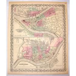
The Cities of Pittsburgh & Allegheny & The City of Cincinnati.
A hand-colored first edition of Colton's interesting two part map of Pittsburgh Pennsylvania and Cincinnati, Ohio. Interestingly, both maps are drawn to the same scale.
Date: New York, 1855
Selling price: ????
Please login to see price!
Sold in 2016
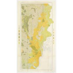
Soil map - Alabama, Huntsville sheet
Early color lithographed soil map by Julius Bien & Co. in New York for the Department of Agriculture. Legends at the side give details on soil type, etc. They also in...
Date: New York 1903
Selling price: ????
Please login to see price!
Sold
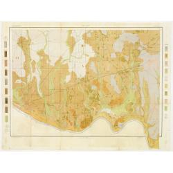
Soil map - Alabama, Mobile sheet.
Early color lithographed soil map by Julius Bien & Co. in New York for the Department of Agriculture. Legends at the side give details on soil type, etc. They also in...
Date: New York, 1903
Selling price: ????
Please login to see price!
Sold in 2017
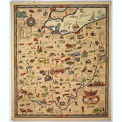
Friendly Service Map of the Commonwealth of Ohio.
A scarce map of the Commonwealth of Ohio, published by the Mobile Oil Company between the wars. A fun and informative map with numerous topical small illustrations, place...
Date: Ohio, ca 1930
Selling price: ????
Please login to see price!
Sold in 2019
