Browse Listings in America > Caribbean & Atlantic Ocean
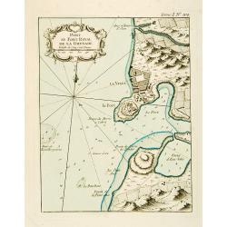
Port et Fort Royal de la Grenade.
This chart shows the territories of the harbour and fortress Royal on the island of Grenada.The only issue of this version of Bellin's map, slightly larger than the commo...
Date: Paris 1764
Selling price: ????
Please login to see price!
Sold
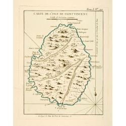
Carte de l'Isle de Saint Vincent.
This chart shows the island of St. Vincent The only issue of this version of Bellin's map, slightly larger than the common version. Depths shown by soundings.From Bellin'...
Date: Paris 1764
Selling price: ????
Please login to see price!
Sold
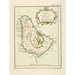
Carte de l'Isle de la Barbade.
This chart shows the island Barbados.The only issue of this version of Bellin's map, slightly larger than the common version. Depths shown by soundings.From Bellin's Peti...
Date: Paris 1764
Selling price: ????
Please login to see price!
Sold
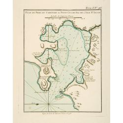
Plan du Port du Carenage ou Petit Cul de Sac de l'Isle Se Lucie.
This chart shows the territories of the harbour of Carenage or Petit Cul de Sac on the island of Sant Lucie.The only issue of this version of Bellin's map, slightly large...
Date: Paris 1764
Selling price: ????
Please login to see price!
Sold
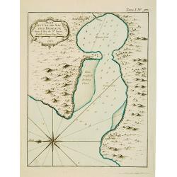
Plan du Cul de Sac des Roseaux dans l'Isle de Ste. Lucie.
This chart shows the territories of Cul de Sac des Roseaux on the island of Saint Lucie. The only issue of this version of Bellin's map, slightly larger than the common v...
Date: Paris 1764
Selling price: ????
Please login to see price!
Sold
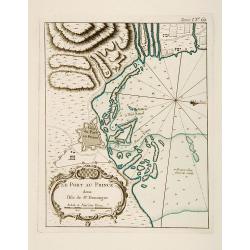
Plan du Port-au-Prince dans l'Isle de St Domingue.
This chart shows the territories of the town of Port-au-Prince on the island St Domingue.The only issue of this version of Bellin's map, slightly larger than the common v...
Date: Paris 1764
Selling price: ????
Please login to see price!
Sold
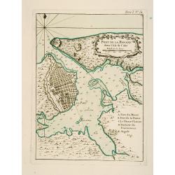
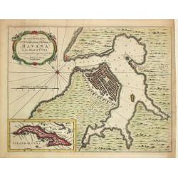
Port de la Havane dans l'Isle de Cube .
This chart shows the territories of the town and harbour of Havana on the island of Cuba.The only issue of this version of Bellin's map, slightly larger than the common v...
Date: Paris 1764
Selling price: ????
Please login to see price!
Sold
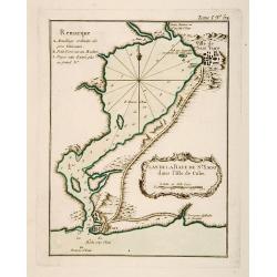
Plan de la Baye de St. Yago dans l'Isle de Cube.
This chart shows the territories and Bay of St. Yago on the island of Cuba.The only issue of this version of Bellin's map, slightly larger than the common version. Depths...
Date: Paris 1764
Selling price: ????
Please login to see price!
Sold
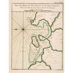
Plan des Havres de Port Antonio et de Saint François Situés a la Coste du Nord Est de la Jamaïque.
This chart shows the territories and harbour of Port Antonio on the island of Jamaica. The only issue of this version of Bellin's map, slightly larger than the common ver...
Date: Paris 1764
Selling price: ????
Please login to see price!
Sold
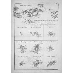
![Suite des Isles Antilles 2.Partie. Together with 2.Partie [2 maps].](/uploads/cache/17123-250x250.jpg)
Suite des Isles Antilles 2.Partie. Together with 2.Partie [2 maps].
These set of 2 chart are showing the Antilles Islands of Guadeloupe, Dominique, Martinique, Grenada, St.Vincent and St. Lucie.The only issue of this version of Bellin's m...
Date: Paris 1764
Selling price: ????
Please login to see price!
Sold
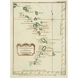
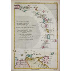
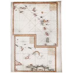
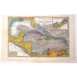
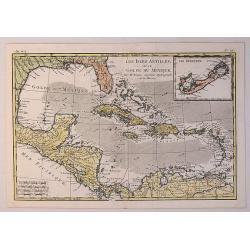
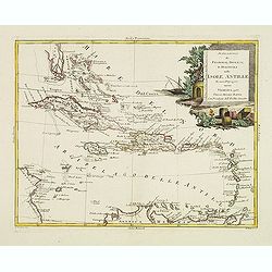
Les Petites Antilles ou Les Isles du Vent.
This chart shows the territories of the smaller Antilles or Windward islands.The only issue of this version of Bellin's map, slightly larger than the common version. Dept...
Date: Paris 1764
Selling price: ????
Please login to see price!
Sold
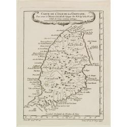
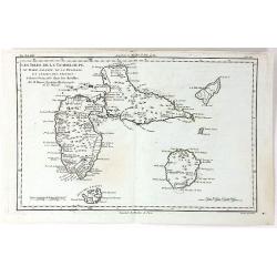
Carte de l'Isle de la Grenade, Pour servir?
Detailed map of the island Grenada by Jacques Nicolas Bellin (1703-1772), one of the most important and proficient French cartographers of the mid-eighteenth century.He w...
Date: Paris 1764
Selling price: ????
Please login to see price!
Sold
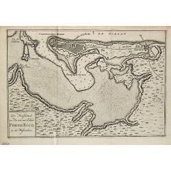
De Hoofdstad en Haven van 't Eiland Porto Rico in de Westindien.
Izaak Tirion (d. 1769) Amsterdam publisher. His 'Nieuwe en beknopte handatlas' saw 6 editions between before 1740 and after 1784. Also 'Tegenwoordige staat van alle volke...
Date: Amsterdam, 1765
Selling price: ????
Please login to see price!
Sold
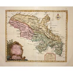
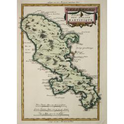
Het Westindisch Eiland Martenique.
Nice, decorative map of Martinique filled with good detail of roads, topography, soundings, villages, windmills, and plantations. The title cartouche incorporates the dis...
Date: Amsterdam, 1765
Selling price: ????
Please login to see price!
Sold
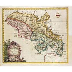
Het Westindische Eiland Marteneque.
Izaak Tirion (d. 1769) Amsterdam publisher. His ' Nieuwe en beknopte handatlas' saw 6 editions between before 1740 and after 1784. Also ' Tegenwoordige staat van alle vol...
Date: Amsterdam, 1765
Selling price: ????
Please login to see price!
Sold in 2010
An exact Plan of the City, Fortifications & Harbour of Havana in the Island of Cuba.
John Hinton (fl.1745, d. 1781), London-based publisher, Universal Magazin 1747-1781. A plan of the town of Havana and direct vincinity. With an inset depicting Cuba. From...
Date: London, Newgate Street, 1752-1765
Selling price: ????
Please login to see price!
Sold in 2008
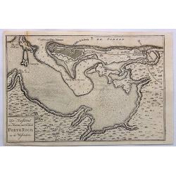
De Hoofdstad en Haven Van't Eiland Porto Rico, in de Westindien.
A detailed plan of San Juan Harbour in Puerto Rico, which appeared in Tirion's “Hedendaagsch Historie of Tegenwordige Staat van Amerika”.The map includes a detailed plan ...
Date: Amsterdam, 1765
Selling price: ????
Please login to see price!
Sold in 2023
![Kaart van geheel GUAJANA of de WILDEN-KUST, en die der Spaansche Westindien [and] Het Eiland KURASSAU. [and] KAART van de Volkplanting aan DEMERARY en RIO D'ESSEQUEBO.](/uploads/cache/82588-250x250.jpg)
Kaart van geheel GUAJANA of de WILDEN-KUST, en die der Spaansche Westindien [and] Het Eiland KURASSAU. [and] KAART van de Volkplanting aan DEMERARY en RIO D'ESSEQUEBO.
A scarce hand-colored map made from four maps together on one sheet, showing the Dutch colonies on the north coast of South America, including Curaçao and Willemstad. Whi...
Date: Amsterdam, 1765
Selling price: ????
Please login to see price!
Sold in 2019

A Plan of the City and Harbour of Havanna, Capital of the Island of Cuba.
A lovely small town plan of the Cuban capital city of Havana, probably published by Baldwin for the "London Magazine" in the mid 1760s. The plan highlights the ...
Date: London, ca 1765
Selling price: ????
Please login to see price!
Sold in 2020
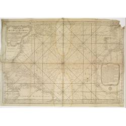
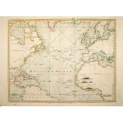
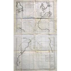
Carte Reduite de l'Ocean Occidental.
Superb sea chart of the Atlantic Ocean by Jacques Nicolas Bellin (1703-1772) the Royal Hydrographer and head of the Depot de la Marine, in Paris.The chart is filled with ...
Date: Paris 1766
Selling price: ????
Please login to see price!
Sold
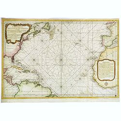
Carte Reduite de l'Ocean Occidental. . .
An attractive mid eighteenth century sea chart published in Paris by Jacques Nicolas Bellin. The chart shows from the north of South America, northwards to the Caribbean,...
Date: Paris, ca 1766
Selling price: ????
Please login to see price!
Sold in 2020
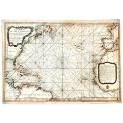
Carte Reduite de l' OCEAN OCCIDENTAL Contenant Partie des Costes d' Europe et d' Afrique... M DCCLXVI.
An decorative maritime chart, by the one of the greatest French hydrographers of the 18th century. In the context of the war at the end of the 18th century, and of the ri...
Date: Paris, 1766
Selling price: ????
Please login to see price!
Sold in 2019
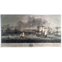
TO S,,r George Pocock KNIGHT of the BATH and Admiral of the Blue Squadron of His Majesty’s Fleet, on the EXPEDITION against the Havannah in 1762, / This PERSPECTIVE VIEW of the Harbour, with the LAND to the West, the MORO CASTLE to
A large, rare view of the British fleet entering the harbor of Havana to take possession of the town, 16 August 1762. Seven Years War (1756-63). Engraved after paintings ...
Date: London, 1766
Selling price: ????
Please login to see price!
Sold in 2021
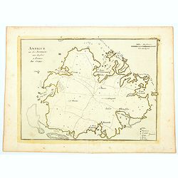
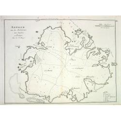
Antigue une des Antilles aux Anglois.
A map of Antigua in the Caribbean published in Paris by Jean Baptist Crepy in the mid eighteenth century. The map shows roads criss-crossing the island, with parishes, vi...
Date: Paris, 1767
Selling price: ????
Please login to see price!
Sold in 2023
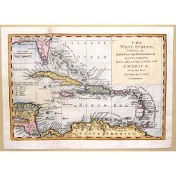
The West Indies Exhibiting the English French Spanish Dutch & Danish Settlements with the Adjacent Parts of North & South America from the Best Authorities
This is a fine map of the Caribbean showing the colonial holdings of Britain, France, Spain, the Netherlands and Denmark after the Treaty of Peace in 1783, by way of a k...
Date: London, 1768
Selling price: ????
Please login to see price!
Sold in 2016
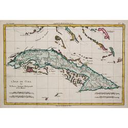
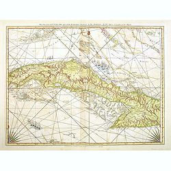
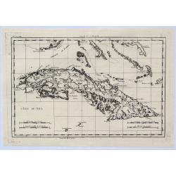
L' Isle de Cuba.
Rigobert Bonne (1727-1795), French cartographer. His maps are found in a.o. Atlas Moderne (1762), Raynal's Histoire Philos. du Commerce des Indes (1774) and Atlas Encyclo...
Date: Paris, c. 1770
Selling price: ????
Please login to see price!
Sold
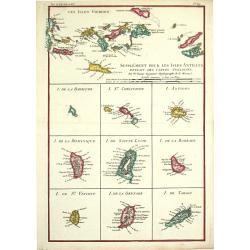
Supplément pour les Isles Antilles.
Rigobert Bonne (1727-1795), French cartographer. His maps are found in a.o. Atlas Moderne (1762), Raynal's Histoire Philos. du Commerce des Indes (1774) and Atlas Encyclo...
Date: Paris, c. 1770
Selling price: ????
Please login to see price!
Sold
Les Isles Antiles et le Golfe du Méxique / Les Bermudes.
Rigobert Bonne (1727-1795), French cartographer. His maps are found in a.o. Atlas Moderne (1762), Raynal's Histoire Philos. du Commerce des Indes (1774) and Atlas Encyclo...
Date: Paris, c. 1770
Selling price: ????
Please login to see price!
Sold
![[Lot of 2 maps] Kaart van de onderkoningschappen van Mexico en Nieuw Granada/ Carte de l'Isle de la Martinique, / antique map of the main Carabean islands] Cuba Insula, inset: Havanna portus; Hispanolia Insula.](/uploads/cache/19646-(1)-250x250.jpg)
[Lot of 2 maps] Kaart van de onderkoningschappen van Mexico en Nieuw Granada/ Carte de l'Isle de la Martinique, / antique map of the main Carabean islands] Cuba Insula, inset: Havanna portus; Hispanolia Insula.
Kaart van de onderkoningschappen van Mexico en Nieuw Granada in de Spaansche West-Indien. Carte de l'Isle de la Martinique, 1838 Together 2 maps .- Kaart van de onderk...
Date: Amsterdam, ca 1770
Selling price: ????
Please login to see price!
Sold in 2025

The British Troops entering the Breach of the Moro Castle Engraved for Mountagues History of England.
The scene "CUBA: BATTLE OF HAVANA", British troops entering the breach in the fortress, Morro Castle, during the Battle of Havana, in the July of 1762. Engraved...
Date: London, 1771
Selling price: ????
Please login to see price!
Sold in 2017
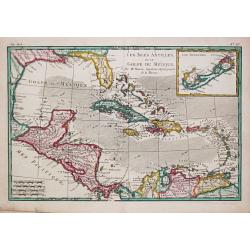
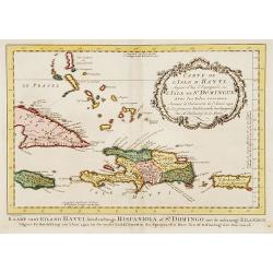
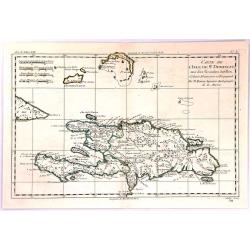
Carte de L'Isle d'Hayti, Aujour d'hui.. St.Domingue..
Uncommon edition of this fine map of Hispaniola and the neighboring islands Jamaica, Caymans, Porto Rico and eastern part of Cuba.Hispaniola divided into the five major c...
Date: Amsterdam, 1773
Selling price: ????
Please login to see price!
Sold
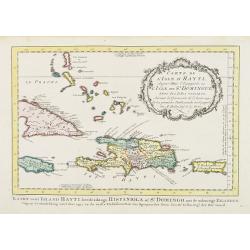
Carte de l' Isle d' Hayti, Aujourd'hui l' Espagnole, ou l' Isle de St. Dominique, Avec les Isles voisines.
Jaques Nicolas Bellin (1702-720) was the most important French hydrographer of the 18th century. Sea-atlas 'Hydrographique Français' , 1756-65, atlas to accompany Prévost...
Date: Amsterdam, 1773
Selling price: ????
Please login to see price!
Sold in 2008
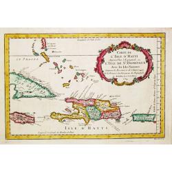
Carte de L'Issle d'Hayti, Aujour d'hui.. St.Domingue..
Uncommon edition of this fine map of Hispaniola and the neighboring islands Jamaica, Caymans, Porto Ricco and eastern part of Cuba. Hispaniola divided into the five major...
Date: Amsterdam, 1773
Selling price: ????
Please login to see price!
Sold in 2020
Carte des Isles Antilles ou du Vent avec la Partie orientale des Isles sous le Vent.
Rigobert Bonne (1727-1795), French cartographer. His maps are found in a.o. Atlas Moderne (1762), Raynal's Histoire Philos. du Commerce des Indes (1774) and Atlas Encyclo...
Date: Paris, 1774
Selling price: ????
Please login to see price!
Sold
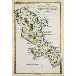
Carte de l\'Isle de la Martinique.
Rigobert Bonne (1727-1795), French cartographer. His maps are found in a.o. Atlas Moderne (1762), Raynal's Histoire Philos. du Commerce des Indes (1774) and Atlas Encyclo...
Date: Paris, 1774
Selling price: ????
Please login to see price!
Sold in 2010
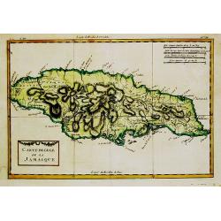
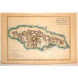
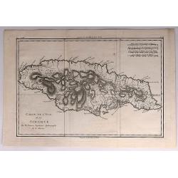
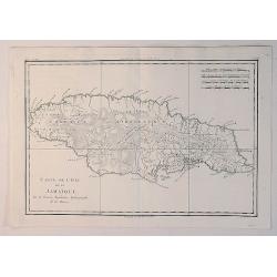
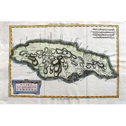
Carte de l''Isle de la Jamaique.
Rigobert Bonne (1727-1795), French cartographer. His maps are found in a.o. Atlas Moderne (1762), Raynal's Histoire Philos. du Commerce des Indes (1774) and Atlas Encyclo...
Date: Paris, 1774
Selling price: ????
Please login to see price!
Sold
Carte de L'Isle de St. Domingue une des Grande Antilles
A copperplate map of the island of Hispaniola by Rigobert Bonne in 1774. With the two sovereign states of the Dominican Republic and Haiti. Also with nearby Caicos and th...
Date: Paris, 1774
Selling price: ????
Please login to see price!
Sold in 2017
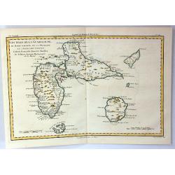
Les Isles de la Guadeloupe, de Marie Galante, de la Désirade et Celles des Saintes...
A map of the French island of Guadeloupe, together with the islands in the vicinity, by Bonne, published in Paris in 1774. Engraved by Dien.Rigobert Bonne (1727-1795), wa...
Date: Paris, 1774
Selling price: ????
Please login to see price!
Sold in 2020
A Chart of the Atlantic Ocean. 1 sheet.
A very fine chart centered on the Atlantic ocean, including a part of western Europe and America continent. London: Printed and sold by Robert Sayer, No. 53 in Fleet Stre...
Date: London, 1775
Selling price: ????
Please login to see price!
Sold in 2008
The Island of Cuba with part of the Bahama Banks and the Martyrs. . .
Engraved nautical chart showing tracks, rhumb lines, currents, etc. Relief shown pictorially, depths by soundings. Covers also the southern Florida Keys and Dry Tortugas....
Date: London, Sayer and Bennett, c.1775
Selling price: ????
Please login to see price!
Sold in 2012
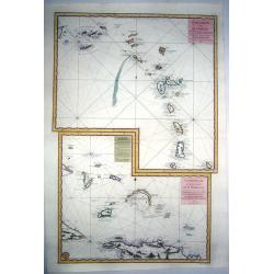
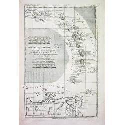
Carte Reduite des ILES ANTILLES - Carte Reduite des Debourquements de St. DOMINGUE.
A striking, large sheet with two maps of the Lesser Antilles (from the eastern tip of Puerto Rico to St. Vincent and Barbados) and of the Turks and Caicos (including part...
Date: Paris, 1775
Selling price: ????
Please login to see price!
Sold in 2020
LESSER ANTILLES,- Carte réduite des îles Antilles au nord du 13me. degré de latitude.. / TURKS-CAICOS-BAHAMAS,- Carte réduite des debouquements de St. Domingue..
Two engraved maps together on one large sheet, the first covering the Leeward Islands from Puerto Rico to Barbados, the second showing the Turks and Caicos Islands and so...
Date: Paris, 1775
Selling price: ????
Please login to see price!
Sold in 2022
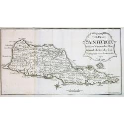
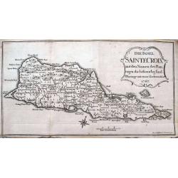
Die Insel SAINTE CROIX mit den Namen der Plan...
Very rare map of the Island of St. Croix (Santa Cruz), one of the US Virgin Islands. Although dated 1767 this it was published in 1777 in Oldendorp's "Geschichte der...
Date: Nuremberg, 1777
Selling price: ????
Please login to see price!
Sold
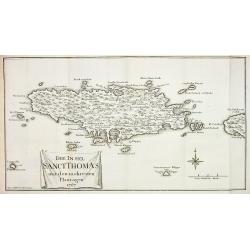
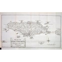
Die Insel Sanct Thomas mit den mehresten Plantagen 1767
Very rare map of the Island of St. Thomas, US Virgin Islands. Although dated 1767 this it was published in 1777 in Oldendorp's "Geschichte der Mission der evangelisc...
Date: Nuremberg, 1777
Selling price: ????
Please login to see price!
Sold
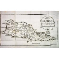
DIE INSEL SAINTE CROIX mit den Namen der Plantagen die bestaendig sind.
Very rare and sought after map of the Island of St. Croix (Santa Cruz), one of the US Virgin Islands. Although dated 1767 this it was published in 1777 in Oldendorp's &qu...
Date: Nuremberg, 1777
Selling price: ????
Please login to see price!
Sold
DIE INSEL SANCT THOMAS mit den mehresten Plantagen 1767
Very rare and sought after map of the Island of St. Thomas, US Virgin Islands. Although dated 1767 it was published in 1777 in Oldendorp's "Geschichte der Mission de...
Date: Nuremberg, 1777
Selling price: ????
Please login to see price!
Sold
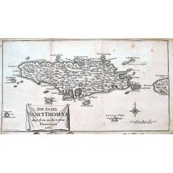
Die Insel Sanct Thomas mit den mehresten Plantagen 1767.
A rare and sought after map of the Island of St. Thomas, US Virgin Islands. Although dated 1767 it was published in 1777 in Oldendorp's "Geschichte der Mission der e...
Date: Nuremberg, 1777
Selling price: ????
Please login to see price!
Sold in 2018
Die Insel Sainte Croix mit den Namen der Plantagen die bestaendig sind.
Very rare and sought after map of the Island of St. Croix (Santa Cruz), one of the US Virgin Islands. Although dated 1767 this it was published in 1777 in Oldendorp's &qu...
Date: Nuremberg, 1777
Selling price: ????
Please login to see price!
Sold in 2022
Antigue une des Antilles aux Anglois...
Detailed copper-engraved chart of Antigua, showing ports, anchor spots, reefs, roads, forts and towns. With key and distance scale.
Date: Paris, 1778
Selling price: ????
Please login to see price!
Sold in 2008

Carte de la Dominique prise par les François Le 7 septembre 1778. . .
A rare, one of the finest maps of Dominica ever produced, with insets of Charlottesville with its attack by the French on 7 September 1778. Also small inset map of the Ca...
Date: Paris, 1778
Selling price: ????
Please login to see price!
Sold
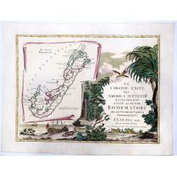
LE COLONIE UNITE dell' AMERICA SETTENTRle di nuova projezione assee li signori. . . (Title Page and Bermuda)
A striking, beautifull, title page of Zatta's twelve sheet monumental work, with inset showing the island of Bermuda. This map is a part of the Italian edition of John Mi...
Date: Venice, 1778
Selling price: ????
Please login to see price!
Sold in 2020
Carte de L\'Isle de la Martinique.
Fine copper engraved map of the Island of Martinique in the Caribbean. It is detailed with lakes, rivers, cities, towns, mountains and forests. Nice block-style cartouche...
Date: Paris, 1779
Selling price: ????
Please login to see price!
Sold in 2014
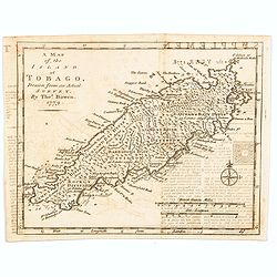
A Map of the Island of Tobago, drawn from an Actual Survey.
An nice, small map delightfully engraved with good detail. The island is sectioned off into seven distinct divisions, each identifying the number of acres and estates. Ne...
Date: London, 1779
Selling price: ????
Please login to see price!
Sold in 2020
CARTE DES ISLES ANTILLES ou du VENT AVEC LA PARTIE ORIENTALE DES ISLES SOUS LE VENT
Beautiful and detailed copper-engraved map the lesser Antilles, from Puerto Rico to the coast of Venezuela. The map bears seven distance scales. From "Atlas de toute...
Date: Paris, c1780
Selling price: ????
Please login to see price!
Sold
SUPPLÉMENT POUR LES ISLES ANTILLES, EXTRAIT DES CARTES ANGLOISES...
Beautiful and detailed copper-engraved map with excellent detail on the Virgin Islands + 9 inset maps of: Barbuda, St. Kitts, Antigua, Dominica, St. Lucia, Barbados, St. ...
Date: Paris, c1780
Selling price: ????
Please login to see price!
Sold
Kaart van het Eiland Jamaika.
An uncommon and very attractive map of Jamaica. The island's mountains are boldly engraved and excellent detail of the various river systems is provided. The parishes are...
Date: Amsterdam, c. 1780
Selling price: ????
Please login to see price!
Sold
Mappa Geographica..Indiae Occidentalis..
Six varying sized insets depict the West Indies: Panama, Saint Augustine, Vera Cruz, Santo Domingo, and, a birds-eye view of Mexico City. The primary, largest inset map h...
Date: Nuremberg, 1780
Selling price: ????
Please login to see price!
Sold
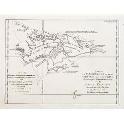
Carte de Maidenland ou de la Virginie de Hawkins.. Et du Canal Falkland..
Fine chart of the Falkland Islands called Maidenland or Virginie by Sir Richard Hawkins who discovered the islands in 1574.Also shows the Canal Falkland, the Strait betwe...
Date: Paris 1780
Selling price: ????
Please login to see price!
Sold
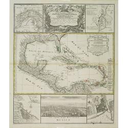
Mappa Geographica.. Indiae Occidentalis..
Six varying sized insets depict the West Indies: Panama, Saint Augustine, Vera Cruz, Santo Domingo, and a birds-eye view of Mexico City. The primary, largest inset map ha...
Date: Nuremberg, 1780
Selling price: ????
Please login to see price!
Sold in 2012
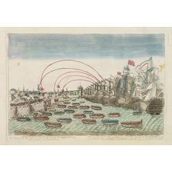
Vue de la prise des forts et ville de havane par les Anglois en 1762.
So-called optical print illustrating a perspective view of the siege of Havana by the English troops in 1762.Mondhare, active at rue St.Jacques a l'Hotel Saumur, was a we...
Date: Paris, c.1780
Selling price: ????
Please login to see price!
Sold in 2016
Les Isles Antilles et le Golfe du Mexique.
A beautiful colored map of the Gulf of Mexico with an inset map of Bermuda Island. From "Atlas de Toutes les Parties Connues du Globe Terrestre". Detailed with ...
Date: Paris - 1780
Selling price: ????
Please login to see price!
Sold in 2013
Carte de L'Isle de la Jamaique.
Hand-colored, copper plate map of the island of Jamaica in the Caribbean. Detailed presentation of the settlements, ports and forts. BONNE, RIGOBERT (1729-1795). Bonne w...
Date: Paris, 1780
Selling price: ????
Please login to see price!
Sold in 2013
Carte Des Declinaisons Et Inclinaisons De L'Aiguille Aimantee Tables 1 and 2.
An important, very large chart of the Atlantic Ocean on two sheets, which can be joined, showing magnetic inclination and declination. Probably compiled from La Perouse's...
Date: Paris, ca 1780
Selling price: ????
Please login to see price!
Sold in 2023
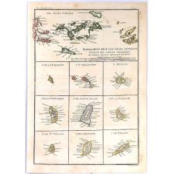
Supplement Pour Les Isles Antilles, Extract des Cartes Angloises
At the top of this interesting group of maps are the Virgin Islands, and below them are nine small maps of Barbuda, Barbados, St Vincent, St. Kitts, Antigua, Dominica, Sa...
Date: Paris, 1780
Selling price: ????
Please login to see price!
Sold in 2017
Les Isles de la Guadeloupe de Marei Galante, de la Desirade et Celles des Saintes.
A map of the French island of Guadeloupe with the islands in the vicinity. Many towns and forts are named, and some topographical details (mountains, rivers, lakes...), a...
Date: Paris, 1780
Selling price: ????
Please login to see price!
Sold in 2019
Carte de L'Isle de la Jamaique.
A fine map of the Island of Jamaica. A good example of Rigobert Bonne and Guilleme Raynal's 1780 map of Jamaica. Detailed, with towns, rivers, some topographical features...
Date: Paris, 1780
Selling price: ????
Please login to see price!
Sold in 2018
Carte des Isles Antilles et du Golfe du Mexique, avec la Majeure partie de la Nouvelle Espagne. Par M. Bonne, Inge´nieur Hydrographe de la Marine. Aoust 1780. . .
The first edition of this scarce large format map of Florida, the Gulf Coast, Texas (almost to Corpus Christi), Mexico, Baja California and Central America, northern Sout...
Date: Paris, 1780
Selling price: ????
Please login to see price!
Sold in 2022
L'Isle de Cuba.
A highly detailed map of Cuba. Also shows a portion of the Bahamas and the Cayman Islands. By Bonne & Raynal in Paris in 1780.Rigobert Bonne (1727-1794) was an influ...
Date: Paris, 1780
Selling price: ????
Please login to see price!
Sold in 2021
Carte de L'Isle de la Jamaique.
A fine example of Rigobert Bonne and Guilleme Raynal's 1780 map of Jamaica. Highly detailed, showing towns, rivers, some topographical features, political boundaries and ...
Date: Paris, 1780
Selling price: ????
Please login to see price!
Sold in 2020
Les Isles Antilles et le Golfe du Mexique.
A fine Bonne / Raynal's 1780 highly desirable map of the West Indies, Gulf of Mexico, Antilles, and Caribbean. The map extends from Florida to the Spanish Main and from M...
Date: Paris, 1780
Selling price: ????
Please login to see price!
Sold in 2021
Kaart van het eiland Jamaika.
An uncommon and very attractive Dutch map of Jamaica. The island's mountains are boldly engraved and there is excellent detail of the various river systems provided. The ...
Date: Amsterdam, ca 1780
Selling price: ????
Please login to see price!
Sold in 2020
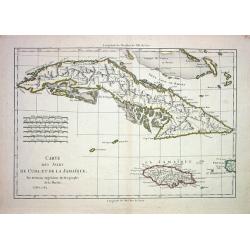
CARTE DES ISLES DE CUBA ET DE LA JAMAIQUE
Very detailed copper-engraved map of Cuba with the southern Bahamas, the Cayman Islands, Jamaica and a small part of Haiti. Many towns are named and some topographical de...
Date: Paris 1782
Selling price: ????
Please login to see price!
Sold
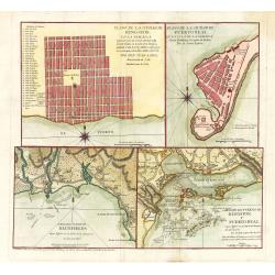
Plano de la Ciudad de Puerto Real, En La Isla De La Jamaica Segun Bontein y la copia de Bellin: Por D. Juan Lopez
This scarce work features a set of four Spanish maps on one sheet depicting Spanish towns and harbor plans of important Jamaican ports.Spanish settlement of Jamaica began...
Date: Madrid, 1782
Selling price: ????
Please login to see price!
Sold in 2023
L'Anse a Chouchou; Le Port Paix; Mouillage de Jean- Rabel; La Baye Moustique; Baye de Tiburon; Baye des Gonayves; La Baye du Fond de la Grange; Port a l'Écu; rade de la Basse-Terre
Nine sea-charts on one sheet, showing various bays and harbors on Hispaniola and Tortuga. Engraved by Dela Haye for the Depot de la Marine. Each section shows depth sound...
Date: Paris, 1784
Selling price: ????
Please login to see price!
Sold in 2014
![L'Anse a Chouchou [with] Le Port Paix [with] Mouillage de Jean- Rabel [with] La Baye Moustique [with] Baye de Tiburon [with] Baye des Gonayves [with] La Baye du Fond de la Grange [with] Port a l'Écu [with] rade de la Basse-Terre. ( 9 plans).](/uploads/cache/36433-250x250.jpg)
L'Anse a Chouchou [with] Le Port Paix [with] Mouillage de Jean- Rabel [with] La Baye Moustique [with] Baye de Tiburon [with] Baye des Gonayves [with] La Baye du Fond de la Grange [with] Port a l'Écu [with] rade de la Basse-Terre. ( 9 plans).
Nine revolutionary war sea on one sheet, showing various bays and harbors on Hispaniola and Tortuga. Engraved by Dela Haye for the Depot de la Marine. Each section shows...
Date: Paris, 1784
Selling price: ????
Please login to see price!
Sold in 2020
Kaart van het eiland Martinique.
Willem Albert Bachiene (1712-1783), Dutch geographer in Maastricht. Most important work ' Heilige Geographie', a work on the Holy Land. Mathijs Schalenkamp published in 1...
Date: Amsterdam, 1785
Selling price: ????
Please login to see price!
Sold
Stabilimenti de Francesi, Inglesi, E Spagnuoli nelle Isole Antille. . .
Uncommon map of Caribbean, including Florida, Bahamas and coast of Venezuela, including Curacao, Artiba I, Buenayre , etc. Engraved by G.Pitteri.
Date: Venice, 1785
Selling price: ????
Please login to see price!
Sold in 2022
Plan de la Baye de l'Acul ( 5 plans on one sheet).
Revolutionary war sea chart with 5 plans of harbours at Santa Domingo in the Caribbean.Relief shown by hachures. Depths shown by soundings. Below engraved seal of Depot G...
Date: Paris, 1785
Selling price: ????
Please login to see price!
Sold in 2020
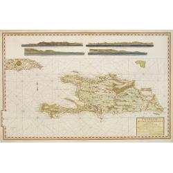
Carte reduite de L'Isle de Saint Domingue.
Very detailed chart made for the official French hydrographical office "Depot générale de la Marine". In top 4 coastal profiles.
Date: Paris, 1787
Selling price: ????
Please login to see price!
Sold
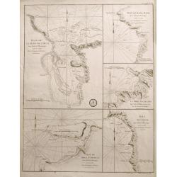
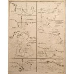
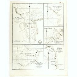
Plan de la Baye de l'Acul; Baye de Dame-Marie; Le Port François; Plan du Môle St. Nicolas; Baye des Irois
Five sea-charts on one large sheet. Engraved by Dela Haye for the Depot de la Marine. Each section shows depth soundings, anchoring places, and coastal information. A ra...
Date: Paris, 1787
Selling price: ????
Please login to see price!
Sold in 2014
