Browse Listings in America > Caribbean & Atlantic Ocean > Caribbean general
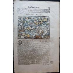
Discovery of America.
The discovery of America by Christopher Columbus from the Cosmographia by Sebastian Münster (ca 1544), on a full leaf. A second full leaf is added with the description o...
Date: Basel, 1544
Selling price: ????
Please login to see price!
Sold in 2020
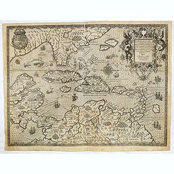
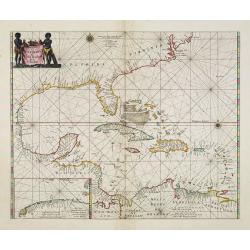
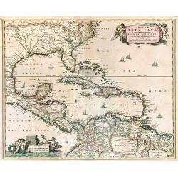
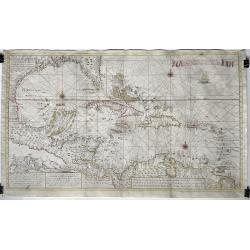
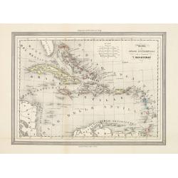
Occidentalis Americae partis.
The most beautifully engraved early map of the Caribbean, including Florida and the South-east. The map includes representations of Columbus' ships and various notes rega...
Date: Frankfurt, 1594
Selling price: ????
Please login to see price!
Sold
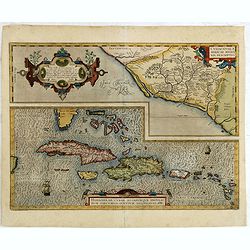
Culiacanae Americae regionis.. / Hispaniolae, Cubae. . .
Two separate virtually identically sized inset maps on one sheet, each with a decorative scroll title cartouche. Culiacanae depicts the coastal and inland western region ...
Date: Antwerp, 1579-1603
Selling price: ????
Please login to see price!
Sold in 2016
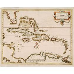
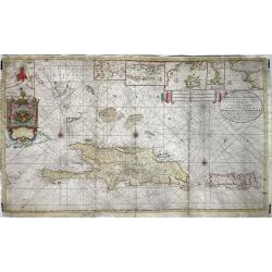
Maiores minores que Insulae Hispaniola, Cuba Lucaia..
Detailed map of the Caribbean, prepared by Hessel Gerritsz, the official map maker for the Dutch West India Company. Gerritsz enjoys a very high reputation for his critic...
Date: Leiden 1630
Selling price: ????
Please login to see price!
Sold
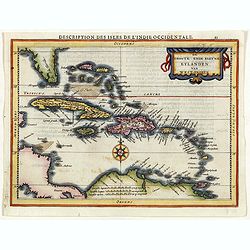
Description des Isles de l'Indie Occidentale.
Map of the Caribbean from the rare Cloppenburg edition slightly larger format and more scarce edition of the Mercator/Hondius "Atlas Minor". Engraved by Pieter ...
Date: Amsterdam, 1630
Selling price: ????
Please login to see price!
Sold in 2019
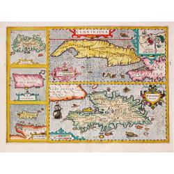
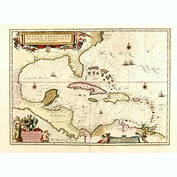
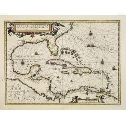
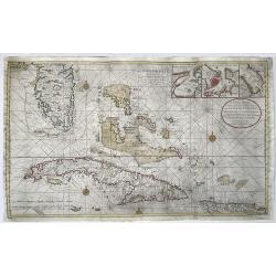
Cuba Insula, Hispaniola Insula, Ins. Jamaica..
One of the earliest maps depicting five of the major West Indian islands. An inset top right shows Havana. The map is exceptionally attractive and beautifully engraved.
Date: Amsterdam, 1630
Selling price: ????
Please login to see price!
Sold in 2014
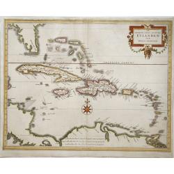
De Groote ende Kleyne Eylanden van West-Indien
This map covers all of the West Indies and the Bahamas and shows the coastline of Florida, Central and South America. The title is contained in a decorative title cartouc...
Date: Amsterdam, 1630
Selling price: ????
Please login to see price!
Sold in 2008
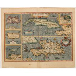
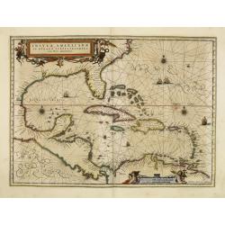
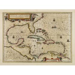
Cuba Insula / Hispaniola insula, insets: Havanna portus, celeberrimus totius indiae Occidentalis; Insula Iamaica; Ins. S. Ioannis; Ins. Margareta Cum Confinijis.
A most decorative map of the main Carabean islands from the Mercator / Hondius Atlas. Embellished with seven strapwork cartouches. Ref.: Koeman, Atlantes Neerlandici,...
Date: Amsterdam, c. 1630
Selling price: ????
Please login to see price!
Sold in 2022
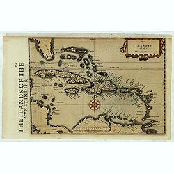
The Ylandes of the West Indies.
Rare map of the West Indies or Caribbean islands from Florida to the northern part of South America. Cartographic elements include degrees of latitude, compass rose, sea ...
Date: London, 1635-1639
Selling price: ????
Please login to see price!
Sold in 2019
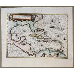
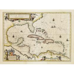
Insulae Americanae in Oceano Septentrionali, cum Terris Adiacentibus.
Early map of the West Indies. Janssonius' edition of Hessel Gerritsz' important map of 1631 made after his voyage to South America and the West Indies during 1628.From Ja...
Date: Amsterdam, 1639
Selling price: ????
Please login to see price!
Sold in 2020
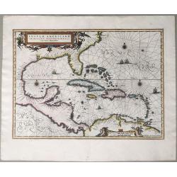
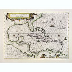
Insulae Americanae in Oceano Septentrionali, cum Terris Adiacentibus.
An early map of the West Indies. Janssonius' edition of Hessel Gerritsz' important map of 1631 made after his voyage to South America and the West Indies during 1628. Fro...
Date: Amsterdam, 1639
Selling price: ????
Please login to see price!
Sold in 2020
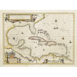
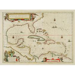
Insulae Americanae in Oceanus Septentrionali cum Terris..
General map of the West Indies extending from Virginia to the mouth of the Orinoco, and destined to be copied in various shapes by many other publishers.Title cartouche t...
Date: Amsterdam, 1642
Selling price: ????
Please login to see price!
Sold
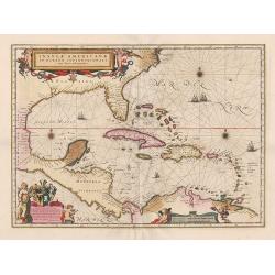
Insulae Americanae in Oceanus Septentrionali cum Terris..
General map of the West Indies extending from Virginia to the mouth of the Orinoco, and destined to be copied in various shapes by many other publishers.Title cartouche t...
Date: Amsterdam 1642
Selling price: ????
Please login to see price!
Sold
Insulae Americanae in oceano septentrionali.
Showing the Gulf of Mexico and the West Indian Islands, and the adjacent North and South American coastlines. The map is based on the map by Gerritsz., except for the add...
Date: Amsterdam, 1639-1644
Selling price: ????
Please login to see price!
Sold in 2014
Insulae Americanae in Oceanus Septentrionali cum Terris..
General map of the West Indies extending from Virginia to the mouth of the Orinoco, and destined to be copied in various shapes by many other publishers. Title cartouche ...
Date: Amsterdam 1647
Selling price: ????
Please login to see price!
Sold
Insulae Americanae in Oceanus Septentrionali, ...
General map of the West Indies extending from Virginia to the mouth of the Orinoco, and destined to be copied in various shapes by many other publishers.
Date: Amsterdam, 1647
Selling price: ????
Please login to see price!
Sold in 2014
Insulae Americanae in Oceanus Septentrionali cum Terris..
General map of the West Indies extending from Virginia to the mouth of the Orinoco, and destined to be copied in various shapes by many other publishers.Title cartouche t...
Date: Amsterdam, 1647
Selling price: ????
Please login to see price!
Sold in 2015
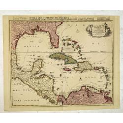
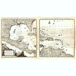
Insulae Americanae in oceano septentrionali..
Finely engraved map, showing the Gulf of Mexico and the West Indian Islands, and the adjacent North and South American coastlines.The cartography is based on the rare Ger...
Date: Amsterdam, 1660
Selling price: ????
Please login to see price!
Sold in 2011
Insulae Americanae in oceano septentrionali..
Finely engraved map, showing the Gulf of Mexico and the West Indian Islands, and the adjacent North and South American coastlines.The cartography is based on the rare Ger...
Date: Amsterdam, 1660
Selling price: ????
Please login to see price!
Sold in 2008
Insulae Americanae in oceano septentrionali..
Finely engraved map, showing the Gulf of Mexico and the West Indian Islands, and the adjacent North and South American coastlines.The cartography is based on the rare Ger...
Date: Amsterdam 1660
Selling price: ????
Please login to see price!
Sold
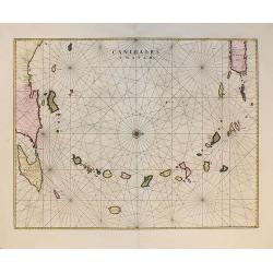
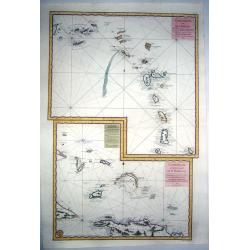
Canibales Insulae.
Rare, early Dutch nautical chart of the Caribbean from Puerto Rico southward, from the first edition of the last part of the Latin "Atlas maior" dedicated to Am...
Date: Amsterdam, 1662
Selling price: ????
Please login to see price!
Sold in 2011
Pascaerte van Westindien de vaste kusten en de eylanden.
A general chart of the West Indies. In the lower left-hand corner an inset (184x96mm.) of the strait between Cuba and the southernmost tip of Florida. A rare and decorati...
Date: Amsterdam, 1666
Selling price: ????
Please login to see price!
Sold in 2013
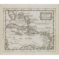
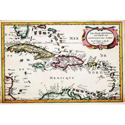
Les Isles Antilles,&c.
Detailed map of the West Indies and Bahamas Islands, with southern most tip of Florida.Published in an early edition of the small Sanson atlas L'Europe Dediée a Monseign...
Date: Paris, P. Marriete, 1667
Selling price: ????
Please login to see price!
Sold in 2008
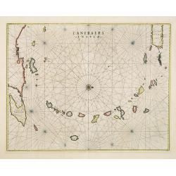
Canibales Insulae.
This is the first Dutch chart to focus on the Lesser Antilles. It covers the Windward and Leeward Isles from Puerto Rico to Trinidad and Margarita. Centered on a compass ...
Date: Amsterdam, 1670
Selling price: ????
Please login to see price!
Sold in 2019
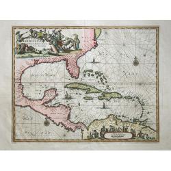
Insulae Americanae in Oceano Septentrionali,
Outstanding map of the West Indies that also incorporates the eastern coast of North America from the Chesapeake through the Gulf of Mexico, Central America and the north...
Date: London,1671
Selling price: ????
Please login to see price!
Sold in 2008
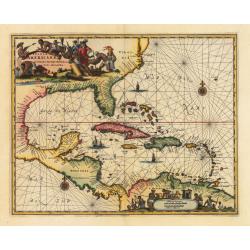
Insulae Americanae in Oceano Septentrionali cum Terris adiacentibus
A fine example of John Ogilby's map of the West Indies, based on Hessel Gerritaz’ chart of 1631 and Blaeu's map of 1635, and Janssons map of 1636. Florida is depicted...
Date: London, 1671
Selling price: ????
Please login to see price!
Sold in 2023
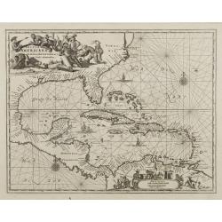
Insulae Americanae in Oceano Septentrionali..
A fine map of the West Indies based on the cartography of Hessel Gerritsz. Encompassing the eastern coast of North America from the Chesapeake through the Gulf of Mexico,...
Date: Amsterdam, 1671
Selling price: ????
Please login to see price!
Sold
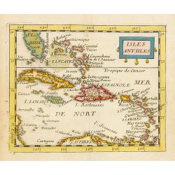
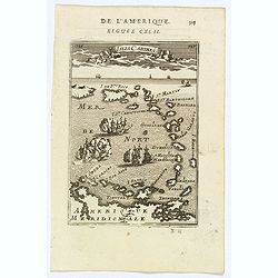
Isles Antilles.
Uncommon miniature map of the Caribbean, including the southern tip of Florida. From Pierre Duval's La Geographie Universeille dated 1676. Following his Cartes de geogr...
Date: Paris, 1676
Selling price: ????
Please login to see price!
Sold in 2014
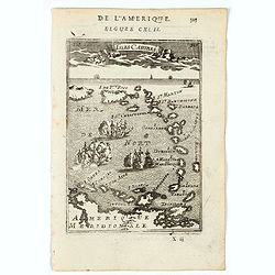
Isles Antlles.
Uncommon miniature map of the Caribbean islands from Pierre Duval's La Geographie Universeille dated 1676. Following his Cartes de geographie in 1657, Pierre Duval publis...
Date: Paris, 1676
Selling price: ????
Please login to see price!
Sold in 2008
Insulae Americanae in Oceano Septentrionali ac Regiones Adiacentes.
A beautiful map that includes the American Southeast, part of Mexico, Central America, and the northern part of South America. Two cartouches with cherubs and mermaids de...
Date: Amsterdam, 1682
Selling price: ????
Please login to see price!
Sold in 2009
Isles Caribes.
A very handsome small map of the Caribbean, extending to include the shores of northern South America. The map is inserted in a prospective view of the Caribbean Sea, whe...
Date: Paris, 1683
Selling price: ????
Please login to see price!
Sold in 2022
Isles Caribes.
A charming map of Caribbean islands, including Puerto Rico, Martinique, St. Christopher, and Aruba, among many others. Many small illustrations of ships in battle. Title ...
Date: Paris, 1683
Selling price: ????
Please login to see price!
Sold in 2022
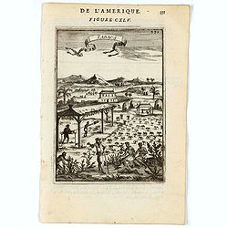
Tabacs.
A charming print illustrating Tabacco cultivation and preparation in the Caribbean. Title in curtain draped at top. French text on verso.From the original 1683 text editi...
Date: Paris, 1683
Selling price: ????
Please login to see price!
Sold in 2022
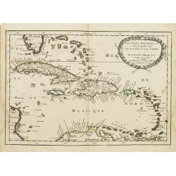
Les isles Antilles.
Nicolas Sanson (1600-67), 'father of the French cartography' and founder of the Sanson firm. Atlas 'Cartes générales de toutes les parties du Monde', 1658-70 and a pock...
Date: Utrecht, S.de Vries / J. Ribius, 1683
Selling price: ????
Please login to see price!
Sold
Stoel des Oorlogs in America Waar in Vertoont Werden Alle Desself Voornaamste Eylande . . .
Large impressive map of the West Indies with the Gulf of Mexico and Florida. The map shows prominently in the center Cuba, Haiti, the Bahamas and Florida, which is here m...
Date: Amsterdam, c. 1720
Selling price: ????
Please login to see price!
Sold in 2014
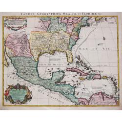
Tabula Geographica Mexicae et Floride des Terres Angloises et des Isles Antilles, du Cours et des Environs de la Riviere de Mississipi. Par G. de l' Isle a Amsterdam chéz Jean Covens & Corneille Mortier. 1722.
Guillaume de l' Isle (1675-1724), Royal Geographer, was the most influential cartographer of the first quarter of the 18th century. ' Atlas de Géographie' (1700-12), pos...
Date: Amsterdam, 1722
Selling price: ????
Please login to see price!
Sold in 2022
Nieuwe en Naeukeurige Afteekening vant Canaal van Bahama... / Nouvelle Carte Marine du Canal de Bahama...
Large size nautical sea chart of the Florida peninsula, Bahamas, Cuba and Hispaniola. Printed on two sheets, joined.Southern Florida and the Keys are depicted with great ...
Date: Amsterdam, 1728
Selling price: ????
Please login to see price!
Sold in 2022
Nouvelle Carte Marine de Toute les Cotes de l´Amerique ... / Nieuwe grote en zeer curieuze Paskaart van Geheel WestIndien ...
Large size sea chart of the Caribbean and surrounding coasts, by Gerard van Keulen, son of Johannes Van Keulen. A rare map since these larger-sized sheets were never publ...
Date: 1728
Selling price: ????
Please login to see price!
Sold in 2022
Nouvelle Carte Particuliere de l'Amerique ou sont Exactement Marquees les Iles de Bermude, la Iamaique, Saint Domingue, les Antilles la Terre Ferme. . .
The two lower maps, with their own border title, of the four-sheet Dutch edition of Popple's monumental map of North America.It covers the region from Bermuda through the...
Date: Amsterdam, 1741
Selling price: ????
Please login to see price!
Sold
Nieuwe en Naaukeurige Paskaart van Het Eyland Hispaniola of St. Domingo met alle desselfs Havenen, Dieptens en Ankergronden, als meede de door passeeringe tusche de Caiques en andere Eylanden. ..
Fine Sea Chart of Puerto Rico and Hispaniola, published by Johannes Van Keulen II. A rare map since these larger sized sheets were never published in atlases but were ra...
Date: 1742
Selling price: ????
Please login to see price!
Sold in 2022
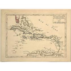
Les Isles Antilles.
Pleasing example of De Vaugondy's scarce map of the Caribbean. Note how Florida looked in the upper left corner. The map appeared in Vaugondy's "Atlas Portatif.&quo...
Date: Paris, 1748
Selling price: ????
Please login to see price!
Sold in 2023
![[Lot of 22 maps / prints] Kaart van Mexico en Nieuw Granada in de Spaansche West-Indien.](/uploads/cache/20690-(3)-250x250.jpg)
[Lot of 22 maps / prints] Kaart van Mexico en Nieuw Granada in de Spaansche West-Indien.
A detailed map showing the Caribbeans, the Gulf of Mexico with its adjacent lands and Central America.. Izaak Tirion (d. 1769) Amsterdam publisher. His ' Nieuwe en beknop...
Date: Amsterdam, c. 1750
Selling price: ????
Please login to see price!
Sold in 2022
![[Lot of 10 maps /views of the Caribbeans], Terre Ferme, Isles Antilles et N.lle Espagne.](/uploads/cache/18346-(1)-250x250.jpg)
[Lot of 10 maps /views of the Caribbeans], Terre Ferme, Isles Antilles et N.lle Espagne.
Louis Brion de la Tour (1756-1823), ' Atlas Géneral, Civil et Ecclésiastique', 1766, ' Atlas Général', 1790-98. Louis Charles Desnos (fl.1750-70), Le Rouge's 'Atlas...
Date: Paris, c. 1760
Selling price: ????
Please login to see price!
Sold in 2022
![[Lot of 2 maps] Kaart van de onderkoningschappen van Mexico en Nieuw Granada/ Carte de l'Isle de la Martinique, / antique map of the main Carabean islands] Cuba Insula, inset: Havanna portus; Hispanolia Insula.](/uploads/cache/19646-(1)-250x250.jpg)
[Lot of 2 maps] Kaart van de onderkoningschappen van Mexico en Nieuw Granada/ Carte de l'Isle de la Martinique, / antique map of the main Carabean islands] Cuba Insula, inset: Havanna portus; Hispanolia Insula.
Kaart van de onderkoningschappen van Mexico en Nieuw Granada in de Spaansche West-Indien. Carte de l'Isle de la Martinique, 1838 Together 2 maps .- Kaart van de onderk...
Date: Amsterdam, ca 1770
Selling price: ????
Please login to see price!
Sold in 2025
LESSER ANTILLES,- Carte réduite des îles Antilles au nord du 13me. degré de latitude.. / TURKS-CAICOS-BAHAMAS,- Carte réduite des debouquements de St. Domingue..
Two engraved maps together on one large sheet, the first covering the Leeward Islands from Puerto Rico to Barbados, the second showing the Turks and Caicos Islands and so...
Date: Paris, 1775
Selling price: ????
Please login to see price!
Sold in 2022
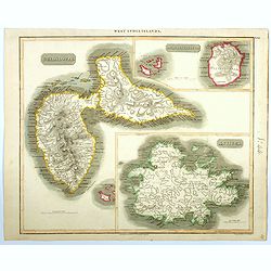
Guadaloupe / Marie Galante / Antigua.
A very finely engraved and detailed map, of both French and English islands in the West Indies. The map is mostly of Guadeloupe, with inset maps of Marie Galante and Anti...
Date: Edinburgh, 1821
Selling price: ????
Please login to see price!
Sold in 2021
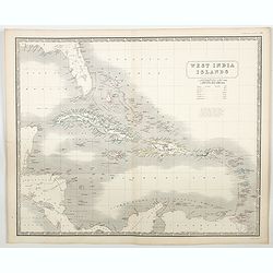
West India Islands.
A large-scale map of Florida, and the Caribbean, while also showing portions of Yucatan, Honduras, Guatemala, Panama, Cartagena and Venezuela, courtesy of the Johnston pu...
Date: Edinburgh, ca 1844
Selling price: ????
Please login to see price!
Sold in 2023
Antille od Indie Occidentali per il geografo T.Duvoteney.
Uncommon Italian map of Caribbean. Map is in outlined color.Many Indian names and settlements.From Geografia Storica and published by Fratelli Doyen in Turin.
Date: Turin, 1857
Selling price: ????
Please login to see price!
Sold in 2023
