Browse Listings in America > Caribbean & Atlantic Ocean
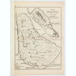
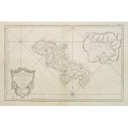
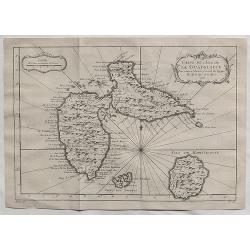
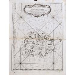
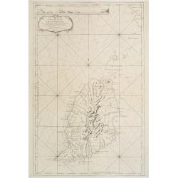
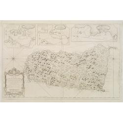
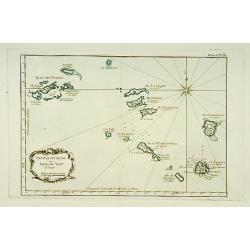
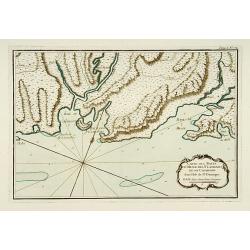
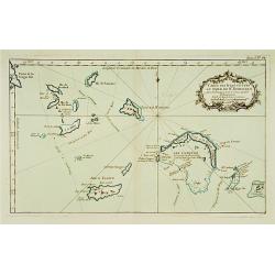
Isle St. Christophle. . ../ La Barbade. . .
Two maps on one sheet: top - St.Christopher and bottom - Barbados. George Louis Le Rouge was active from 1740 until 1780 as a publisher, and was appointed engineer for th...
Date: Paris, 1757
Selling price: ????
Please login to see price!
Sold in 2020
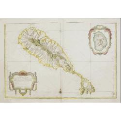
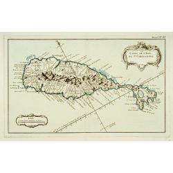
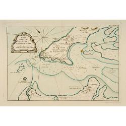
Carte Réduite De L'Isle De Saint Christophe..
A well engraved and highly detailed large-scale map of St. Kitts, with highly detailed topography , many place names, and a beautiful title cartouche. At the upper right ...
Date: Paris, 1758
Selling price: ????
Please login to see price!
Sold in 2018
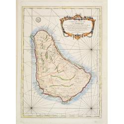
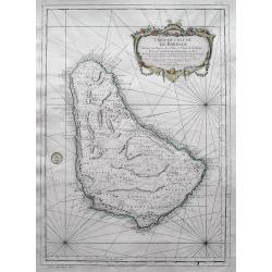
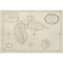
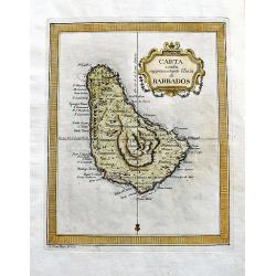
Carte de L'Isle de la Barbade Dressee au depost des cartes et plans de la marine..
This large scale coastal chart of Barbados, with hand-coloring, large decorative cartouche. Bellin (1703-1772) began working for the newly established Dépôt des Cartes ...
Date: Paris 1758
Selling price: ????
Please login to see price!
Sold
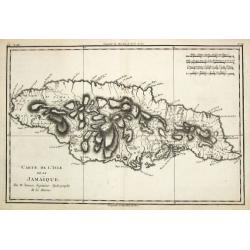
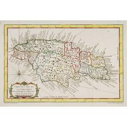
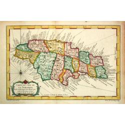
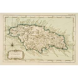
Carte de l?Isle de La Jamaique.
Jaques Nicolas Bellin (1702-720) was the most important French hydrographer of the 18th century. Sea-atlas 'Hydrographique Français' , 1756-65, atlas to accompany Prévo...
Date: Paris, 1758
Selling price: ????
Please login to see price!
Sold
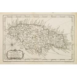
Carte de L'Isle de La Jamaique..
A good engraved map of the island with rococo title cartouche lower left.
Date: Paris, 1758
Selling price: ????
Please login to see price!
Sold in 2017
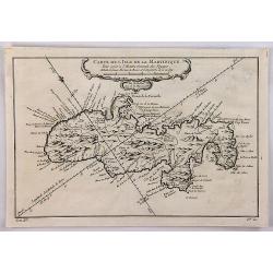
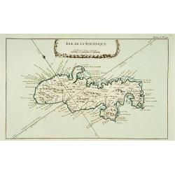
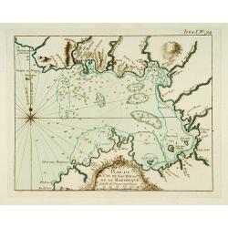
Carte Réduite de l'Isle de la Martinique Dresée au Dépost des Cartes et Journaux de la Marine Pour le Service des Vaisseaux du Roy. Par ordre de M. de Moras Ministre et Secretaire d'Etat ayant le Département de la Marine.
This handsome large scale chart shows parishes, towns, plantations, windmills, roads anchorages and a few soundings. The inset shows a close up of the town and harbor of ...
Date: Paris 1758
Selling price: ????
Please login to see price!
Sold
Carte de L'Isle de La Jamaique..
A good engraved map of the island Jamaica with rococo title cartouche lower left. From l'Histoire générale des voyages .
Date: Paris 1758
Selling price: ????
Please login to see price!
Sold
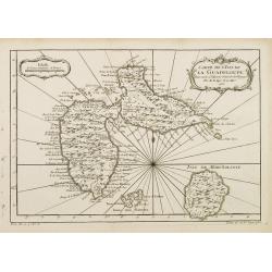
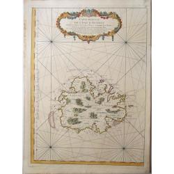
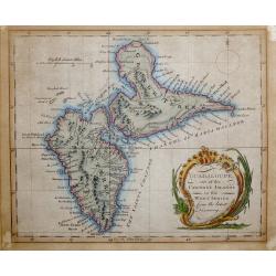
Carte de L'Isle de la Guadeloupe.
A good engraved map of Guadeloupe. The geographical features are typical with somewhat exaggerated bays and inlets. From l'Histoire générale des voyages .
Date: Paris 1758
Selling price: ????
Please login to see price!
Sold
Carte de l?Isle de La Jamaique.
Jaques Nicolas Bellin (1702-720) was the most important French hydrographer of the 18th century. Sea-atlas 'Hydrographique Français' , 1756-65, atlas to accompany Prévo...
Date: Paris, 1758
Selling price: ????
Please login to see price!
Sold
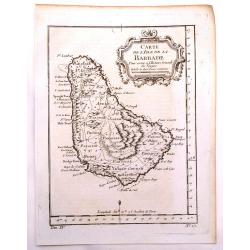
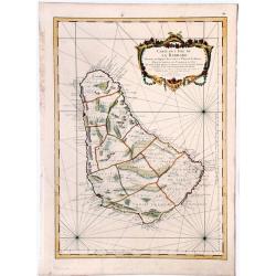
Carte de L'isle de la Barbade.
One of the finest early maps or charts of Barbados. The island is divided into parishes and details cities & towns, mountains, forests, anchorages, shoals, rocks, etc...
Date: Paris, 1758
Selling price: ????
Please login to see price!
Sold in 2017
Carte de l'Isle de la Barbade dressee au Depost des Cartes et Plans de la Marine...
Bellin's famous large scale map of Barbados - one of the best antique maps of the island, with many details such as parishes, villages, churches, streets, anchorages, sho...
Date: Paris, 1758
Selling price: ????
Please login to see price!
Sold in 2016
Carte de l'Isle de la Martinique.
A well engraved map of Martinique. The geographical features are typical, with somewhat exaggerated bays and inlets. From the l'Histoire Générale des Voyages. It featur...
Date: Paris, 1758
Selling price: ????
Please login to see price!
Sold in 2018
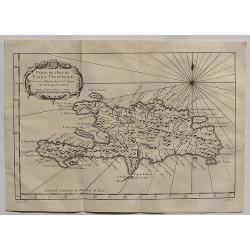
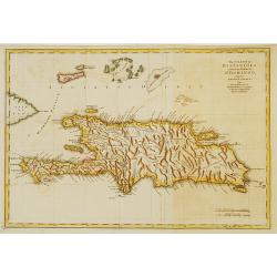
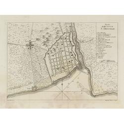
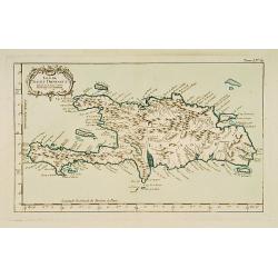
Carte de L'Isle de Saint Domingue.
A fine 1758 Bellin map of the Dominican Republic and Haiti. Taken from a later edition of Abbe A.F. Prevost d'Exiles's "Histoire generale des voyages". It featu...
Date: Paris, 1758
Selling price: ????
Please login to see price!
Sold in 2020
Carte de L'Isle de la Guadaloupe.
A fine 1758 Bellin map of Guadeloupe. Taken from a later edition of Abbe A.F. Prevost d'Exiles's "Histoire generale des voyages". It features a decorative flora...
Date: Paris, 1758
Selling price: ????
Please login to see price!
Sold in 2020
Carte de l'Isle de la Barbade.
A large engraved nautical chart,also showing the division of the Parishes, towns and fortifications. An exceptional onboard document of this rare and fabulous maritime at...
Date: Paris, 1758
Selling price: ????
Please login to see price!
Sold in 2020
ANTIGUA, - Carte reduite de l'isle d'Antigue ; dressée au Dépost des cartes, plans et journaux de la marine : pour le service des vaisseaux du roy. . .
A very rare and large nautical map of the island of Antigua, by Bellin, at Dépost des cartes, plans et journaux de la marine. Relief shown pictorially. Depths by soundin...
Date: Paris, 1758
Selling price: ????
Please login to see price!
Sold in 2022
Carte réduite de l'isle d'Antigue
Large and detailed chart of Antigua. One of the best 18th Century maps of the island. Shows villages, windmills, hills, streets, Parishes, bays, anchorages, depth soundin...
Date: Paris, 1758
Selling price: ????
Please login to see price!
Sold in 2022
Guadeloupe, one of the Caribee Islands in the West Indies from the latest Discovery.
Guadeloupe, one of the Caribee Islands in the West Indies from the latest Discovery. By John Hinton. Published in London March 1759, in "The Universal Magazine of Kn...
Date: London 1759
Selling price: ????
Please login to see price!
Sold in 2015
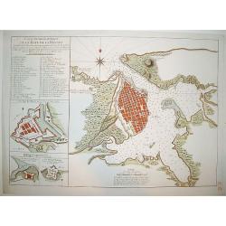
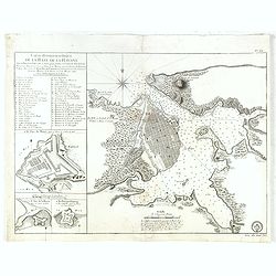
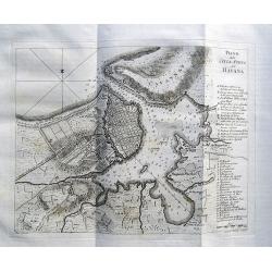
Carte Hydrographique de la Baye de la Havane
A beautifully engraved and detailed chart of the bay of Havana and plan of the city itself. Includes three inset plans of Havana's principal fortifications and a 45 point...
Date: Paris, ca 1760
Selling price: ????
Please login to see price!
Sold
The island of Hispaniola called by the French St.Domingo..
The much contested island of Hispaniola at the height of the French side's prosperity, from Jeffery's The Natural and Civil History of the French Dominions in North and S...
Date: London 1760
Selling price: ????
Please login to see price!
Sold
Carte de l'Isle de la Grenade..
This chart shows the island Grenada. It contains an inset coastal profile and numerous rhumb linesJacques Nicolas Bellin (1703-1772) was one of the most important and pro...
Date: Paris 1760
Selling price: ????
Please login to see price!
Sold
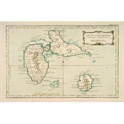
Carte Reduite des Isles de la Guadeloupe Marie Galante et les Saintes..
Superb large-scale sea chart with great detail of parishes, forts, towns, settlements, anchorages and topography. Includes Guadeloupe, Isles de Saintes and Marie Galante ...
Date: Paris 1760
Selling price: ????
Please login to see price!
Sold in 2008
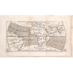
Representation du Cours Ordinaire des Vents de Traverse Qui Regnent le Long des Cotes dans la Mer Atlantique & celle des Indes.
This map shows the prevailing winds in the North Atlantic and Indian Oceans. Published in "Histoire Generale des Voyages". The engraver was Cosmant. Jacques N...
Date: Paris, 1760
Selling price: ????
Please login to see price!
Sold in 2019
![Carte Reduite de L'Isle de Cube [Cuba]. Dressee au Depoit des Cartes et Plans de la Marine. . .](/uploads/cache/84494-250x250.jpg)
Carte Reduite de L'Isle de Cube [Cuba]. Dressee au Depoit des Cartes et Plans de la Marine. . .
A well engraved and highly detailed nautical chart of Cuba. It shows soundings, anchorage's, channels, shoals, navigational sightings. Also shows small parts of Florida a...
Date: Paris, 1760
Selling price: ????
Please login to see price!
Sold in 2021
![[A lot of 5 map of Guyana.] Land-kaart van Cayenne.](/uploads/cache/20452-250x250.jpg)
[A lot of 5 map of Guyana.] Land-kaart van Cayenne.
An attractive map of the island and settlement of Cayenne, with an inset picturing a plan of the town and fort of Cayenne. Izaak Tirion (d. 1769) Amsterdam publisher. H...
Date: Amsterdam, c. 1760
Selling price: ????
Please login to see price!
Sold in 2022
![[Lot of 10 maps /views of the Caribbeans], Terre Ferme, Isles Antilles et N.lle Espagne.](/uploads/cache/18346-(1)-250x250.jpg)
[Lot of 10 maps /views of the Caribbeans], Terre Ferme, Isles Antilles et N.lle Espagne.
Louis Brion de la Tour (1756-1823), ' Atlas Géneral, Civil et Ecclésiastique', 1766, ' Atlas Général', 1790-98. Louis Charles Desnos (fl.1750-70), Le Rouge's 'Atlas...
Date: Paris, c. 1760
Selling price: ????
Please login to see price!
Sold in 2022
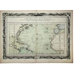
CARTE REDUITE de l' OCEAN OCCIDENTAL, Contenant les Costes Occidentales de l'Europe et de l' Afrique et les Cotes Orientales de l'Amerique . . .
This beautifully engraved chart shows the Atlantic Ocean north of the equator, delineated with rhumb lines. A good portion of each of the continents is shown with major p...
Date: Paris, 1761
Selling price: ????
Please login to see price!
Sold in 2020
Carte Réduite De L'Isle De Cube..
A well engraved and highly detailed chart that was issued in Neptune americo-septentrionale. This chart is based on Sayer & Bennett's chart that was issued in 1776 an...
Date: Paris, 1762
Selling price: ????
Please login to see price!
Sold
Carte de l\' Isle de la Martinique.
Homann Heirs (of Johann Baptist and Johann Christof) published: Grosser Atlas, 1731, 1737. Geogr. Maior, 1759, Atlas Homannianus, 1762.A map of the island of Martinique.
Date: Nürnberg, 1762
Selling price: ????
Please login to see price!
Sold in 2011
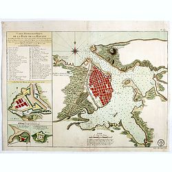
Carte Hydrographique de la Baye de la Havane.. N° 69.
A well engraved and highly detailed of the walled city of Havana and its harbor features inset plans of three forts (La Punta, El Morro, and La Real Fuerza) as well as a...
Date: Paris, 1762
Selling price: ????
Please login to see price!
Sold in 2016
Carte Hydrographique de la Baye de la Havane.. N° 69.
A well engraved and highly detailed of the walled city of Havana and its harbor features inset plans of three forts (La Punta, El Morro, and La Real Fuerza) as well as a...
Date: Paris, 1762
Selling price: ????
Please login to see price!
Sold in 2018
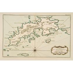
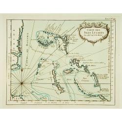
Carte de l'Isle de Sainte Lucie..
Attractive double page chart of St. Lucia with inset plans ('Port du Carenage', Cul de sac des Roseaux' and 'Mouillages du Grand Islet et du Choc', illustrating some deta...
Date: Paris 1763
Selling price: ????
Please login to see price!
Sold in 2008
Piano della Citta di S.Domingo.
An Italian edition of the Jeffery's plan of Santo Domingo city from the Gazzettiere Americano.
Date: Livorno, 1763
Selling price: ????
Please login to see price!
Sold in 2008
Piano della Città e Porto dell' Havana.
An interesting map of Havanna, with its harbour, drawn by Giuseppe Pazzi and engraved by Violanta Vanni for Coltellinis Il Gazzettiere Americano.With numerous depth sound...
Date: Livorno, 1763
Selling price: ????
Please login to see price!
Sold in 2017
Carta esatta rappresentante l'isola di Barbados.
A fine map of Barbados published in the "Gazzetiere Americano". Engraved by V. Rossi. In nice and decorative colors, and in good condition!
Date: Livorno, 1763
Selling price: ????
Please login to see price!
Sold in 2020
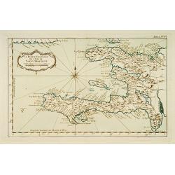
la Partie Francoise de l'Isle de Saint Domingue.
This chart shows the territories of what is today Haiti.The only issue of this version of Bellin's map, slightly larger than the common version. From Bellin's Petit atlas...
Date: Paris 1764
Selling price: ????
Please login to see price!
Sold
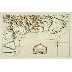
Environs de Leogane et du Port-au-Prince.
A highly detailed map of the area between Leogane and Port au Prince on Hispaniola, with a lovely decorative cartouche.The only issue of this version of Bellin's map, sli...
Date: Paris 1764
Selling price: ????
Please login to see price!
Sold
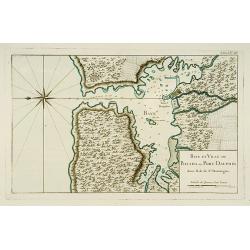
Baye et Ville de Bayaha ou Port Dauphin dans l'Isle de Saint-Domingue.
A detailed chart of the harbour of Banana on the north coast of what is today Haiti.The only issue of this version of Bellin's map, slightly larger than the common versio...
Date: Paris 1764
Selling price: ????
Please login to see price!
Sold
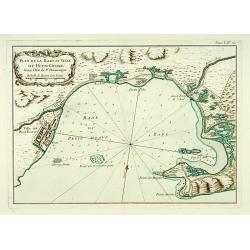
Plan de la Rade et Ville du Petit Goave dans l'Isle de St Domingue.
A very detailed chart of Petit Goave and l'Acul on the north coast of what is today Haiti.The only issue of this version of Bellin's map, slightly larger than the common ...
Date: Paris 1764
Selling price: ????
Please login to see price!
Sold
Petites Antilles ou Isle du Vent.. 3ème. Partie.
This chart shows The Windward Islands from the Virgin Islands to Antigua.The only issue of this version of Bellin's map, slightly larger than the common version. Depths s...
Date: Paris 1764
Selling price: ????
Please login to see price!
Sold
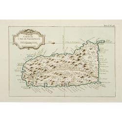
Carte de l'Isle de Saint-Christophe.
This chart shows the island of St. Kitts. Shows interesting topographic details, notes, ports, anchorages, etc.The only issue of this version of Bellin's map, slightly la...
Date: Paris 1764
Selling price: ????
Please login to see price!
Sold
Isle de Guadeloupe les Saintes et Marie Galante.
This chart shows the islands of Guadeloupe, Les Saintes et Marie Galante.The only issue of this version of Bellin's map, slightly larger than the common version. Depths s...
Date: Paris 1764
Selling price: ????
Please login to see price!
Sold
![Partie occidentale de l'Isle de la Guadeloupe appellée la Basse Terre. / Partie Orientale de l'Isle de la Guadeloupe.. [2 maps]](/uploads/cache/17051-250x250.jpg)
Partie occidentale de l'Isle de la Guadeloupe appellée la Basse Terre. / Partie Orientale de l'Isle de la Guadeloupe.. [2 maps]
A set of 2 maps showing the northern and southern islands of Guadeloupe.The only issue of this version of Bellin's maps, slightly larger than the common version. Depths s...
Date: Paris 1764
Selling price: ????
Please login to see price!
Sold
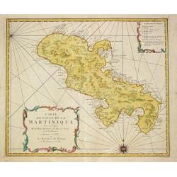
Isle de la Martinique.
This chart shows the island of Martinique,.The only issue of this version of Bellin's map, slightly larger than the common version.From Bellin's Petit atlas maritime.Tome...
Date: Paris 1764
Selling price: ????
Please login to see price!
Sold
![Partie Septentrionale de la Martinique. / Partie Meridionale de la Martinique. [set of 2 maps]](/uploads/cache/17054-250x250.jpg)
Partie Septentrionale de la Martinique. / Partie Meridionale de la Martinique. [set of 2 maps]
A set of two maps depicting the island Martinique.Engraved by Croisey. The only issue of this version of Bellin's map, slightly larger than the common version. Depths sho...
Date: Paris 1764
Selling price: ????
Please login to see price!
Sold
Partie du Cul de Sac Royal de la Martinique.
This chart shows the territories of the bay around Fort Royal on the island of Martinique.The only issue of this version of Bellin's map, slightly larger than the common ...
Date: Paris 1764
Selling price: ????
Please login to see price!
Sold
Carte de l'Isle de Sainte Lucie.
This chart shows the island Saint Lucie.The only issue of this version of Bellin's map, slightly larger than the common version.From Bellin's Petit atlas maritime.Tome I ...
Date: Paris 1764
Selling price: ????
Please login to see price!
Sold
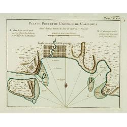
Plan du Port et du Carenage de Cariacoua.
A map of the proposed city and harbour of Carenage de Cariacoua, on the island of St. Vincent.The only issue of this version of Bellin's map, slightly larger than the com...
Date: Paris 1764
Selling price: ????
Please login to see price!
Sold
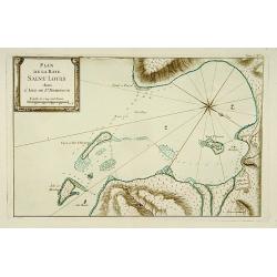
Plan de la Baye Saint Louis dans l'Isle de Saint Domingue.
This chart shows the Bay of Saint Louis on the island Saint-Domingue.The only issue of this version of Bellin's map, slightly larger than the common version. Depths shown...
Date: Paris 1764
Selling price: ????
Please login to see price!
Sold
Carte des Bayes Du Mesle des Flamands et de Cavaillon dans l'Isle de St Domingue.
This chart shows the south coast of St Domingo, with the bay area's of Bayes du Mesle des Flamands and Cavaillon.The only issue of this version of Bellin's map, slightly ...
Date: Paris 1764
Selling price: ????
Please login to see price!
Sold
Port et Ville de Porto-Rico dans l'Isle de ce nom.
This chart shows the territories of the harbour and town of "Porto Rico" on St. Jean Island, St. John. The only issue of this version of Bellin's map, slightly ...
Date: Paris 1764
Selling price: ????
Please login to see price!
Sold
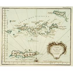
Carte des isles des vierges.
This chart shows the Virgin Islands with island Saint Croix.The only issue of this version of Bellin's map, slightly larger than the common version.From Bellin's Petit at...
Date: Paris 1764
Selling price: ????
Please login to see price!
Sold
Carte de l'Isle St-Thomas l'Une des Vierges.
This chart shows the island St-Thomas.The only issue of this version of Bellin's map, slightly larger than the common version. Depths shown by soundings.From Bellin's Pet...
Date: Paris 1764
Selling price: ????
Please login to see price!
Sold
Carte de l'Isle de la Jamaïque.
This chart shows the island of Jamaica.The only issue of this version of Bellin's map, slightly larger than the common version.From Bellin's Petit atlas maritime.Tome I N...
Date: Paris 1764
Selling price: ????
Please login to see price!
Sold
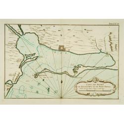
Carte des Havres de Kingstown et de Port Royal.
This chart shows the harbour of Kingston and the fortress of Port Royal.The only issue of this version of Bellin's map, slightly larger than the common version. Depths sh...
Date: Paris 1764
Selling price: ????
Please login to see price!
Sold
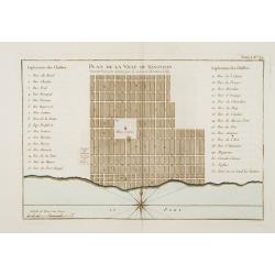
Plan de la Ville de Kingston Suivant le projet donné par le Colonel Christian Lilly.
Plan of the city of Kingston on Jamaica. With a numbered key (1-32) referring to the names of the principal streets.The only issue of this version of Bellin's map, slight...
Date: Paris 1764
Selling price: ????
Please login to see price!
Sold
Isle de St Domingue.
This chart shows the island St Domingue.The only issue of this version of Bellin's map, slightly larger than the common version. Depths shown by soundings.From Bellin's P...
Date: Paris 1764
Selling price: ????
Please login to see price!
Sold
Carte des Isles situées au Nord de St Domingue Avec les Passages pour le retour appellés Débouquemens.
This chart shows the territories of the Caicos Islands and Acklins islands, north of St. Domingue.The only issue of this version of Bellin's map, slightly larger than the...
Date: Paris 1764
Selling price: ????
Please login to see price!
Sold
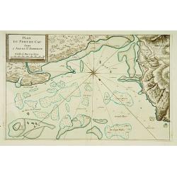
Plan Du Port du Cap dans l'Isle de St. Domingue.
This chart shows the harbour of Cap on the island St-Domingue.The only issue of this version of Bellin's map, slightly larger than the common version. Depths shown by sou...
Date: Paris 1764
Selling price: ????
Please login to see price!
Sold
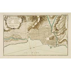
Ville du Cap dans l'Isle de St Domingue.
This chart shows the territories of city of Cap in Isle of St Domingue. Engraved by Croisey.The only issue of this version of Bellin's map, slightly larger than the commo...
Date: Paris 1764
Selling price: ????
Please login to see price!
Sold
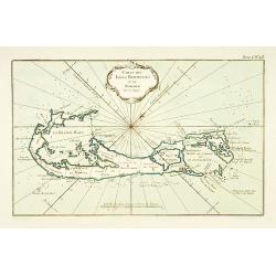
Carte des Isles Bermudes ou de Sommer.
This chart shows the island of Bermuda.The only issue of this version of Bellin's map, slightly larger than the common version. Depths shown by soundings.From Bellin's Pe...
Date: Paris 1764
Selling price: ????
Please login to see price!
Sold
Carte des Isles Lucayes.
This chart shows the territories of the Bahamas, and the East coast of southern Florida. The only issue of this version of Bellin's map, slightly larger than the common v...
Date: Paris 1764
Selling price: ????
Please login to see price!
Sold
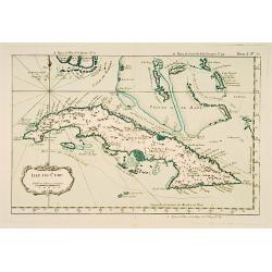
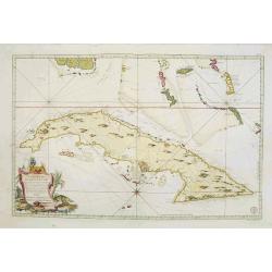
Isle de Cube.
This chart shows the island of Cuba.The only issue of this version of Bellin's map, slightly larger than the common version. Depths shown by soundings.From Bellin's Petit...
Date: Paris 1764
Selling price: ????
Please login to see price!
Sold
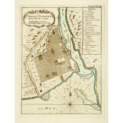
Ville de St. Domingue dans l'Isle de ce Nom.
This chart shows a plan of the city of Santo Domingo on the Dominican Republic. With a lettered key to the principal places in town.The only issue of this version of Bell...
Date: Paris 1764
Selling price: ????
Please login to see price!
Sold
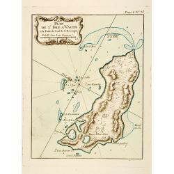
Plan de l'Isle A Vache a la Coste Sud de S. Domingue.
This chart shows the little island l'Isle à Vache on present day Haiti.The only issue of this version of Bellin's map, slightly larger than the common version. Depths sh...
Date: Paris 1764
Selling price: ????
Please login to see price!
Sold
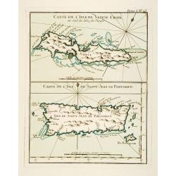
Carte de l'Isle de Sainte Croix au Sud des Isles des Vierges. / Carte de l'Isle de Saint Jean de Portorico.
This chart shows the islands of Sainte Croix and Isle Saint Jean de Porto Rico The only issue of this version of Bellin's map, slightly larger than the common version. De...
Date: Paris 1764
Selling price: ????
Please login to see price!
Sold
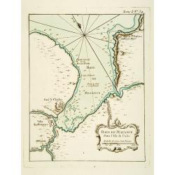
Baye de Matance dans l'Isle de Cube.
This chart shows the Bay of Matance on the island of Cuba.The only issue of this version of Bellin's map, slightly larger than the common version. Depths shown by soundin...
Date: Paris 1764
Selling price: ????
Please login to see price!
Sold
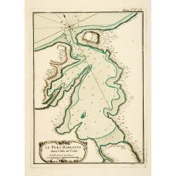
Le Port Marianne dans l'Isle de Cube.
This chart shows the bay of the harbour of Marianne on the island of Cuba. The only issue of this version of Bellin's map, slightly larger than the common version. Depths...
Date: Paris 1764
Selling price: ????
Please login to see price!
Sold
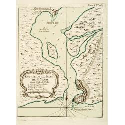
Entrée de la Baye de St Yago dans l'Isle de Cube.
This chart shows the bay of St Yago on the island of Cuba.The only issue of this version of Bellin's map, slightly larger than the common version. Depths shown by soundin...
Date: Paris 1764
Selling price: ????
Please login to see price!
Sold
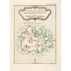
Carte de l'Isle d'Antigue Située par la Latitude 17 Degrés et par la Longitude de 64 Degrés à l'Occident de Paris
This chart shows the island of Antigua.The only issue of this version of Bellin's map, slightly larger than the common version. Depths shown by soundings.From Bellin's Pe...
Date: Paris 1764
Selling price: ????
Please login to see price!
Sold
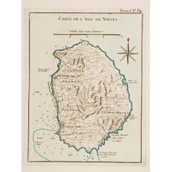
Carte de l'Isle de Nieves.
This chart shows the island of Nieves. The only issue of this version of Bellin's map, slightly larger than the common version. Depths shown by soundings.From Bellin's Pe...
Date: Paris 1764
Selling price: ????
Please login to see price!
Sold
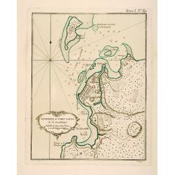
Environs du Fort Louis de la Guadeloupe.
This chart shows the territories around Fort Louis on the island of Guadeloupe The only issue of this version of Bellin's map, slightly larger than the common version. De...
Date: Paris 1764
Selling price: ????
Please login to see price!
Sold
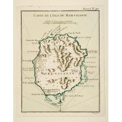
Carte de l'Isle de Marie-Galante.
This chart shows the territories of Isle Marie-Galante The only issue of this version of Bellin's map, slightly larger than the common version. Depths shown by soundings....
Date: Paris 1764
Selling price: ????
Please login to see price!
Sold
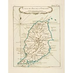
Carte de l'Isle de la Grenade.
This chart shows the island Granada.The only issue of this version of Bellin's map, slightly larger than the common version. Depths shown by soundings.From Bellin's Petit...
Date: Paris 1764
Selling price: ????
Please login to see price!
Sold
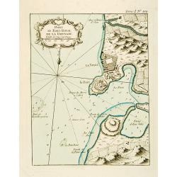
Port et Fort Royal de la Grenade.
This chart shows the territories of the harbour and fortress Royal on the island of Grenada.The only issue of this version of Bellin's map, slightly larger than the commo...
Date: Paris 1764
Selling price: ????
Please login to see price!
Sold
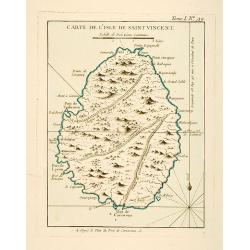
Carte de l'Isle de Saint Vincent.
This chart shows the island of St. Vincent The only issue of this version of Bellin's map, slightly larger than the common version. Depths shown by soundings.From Bellin'...
Date: Paris 1764
Selling price: ????
Please login to see price!
Sold
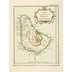
Carte de l'Isle de la Barbade.
This chart shows the island Barbados.The only issue of this version of Bellin's map, slightly larger than the common version. Depths shown by soundings.From Bellin's Peti...
Date: Paris 1764
Selling price: ????
Please login to see price!
Sold
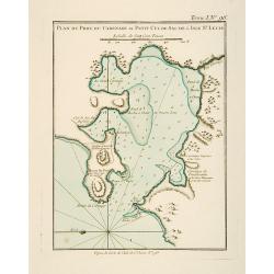
Plan du Port du Carenage ou Petit Cul de Sac de l'Isle Se Lucie.
This chart shows the territories of the harbour of Carenage or Petit Cul de Sac on the island of Sant Lucie.The only issue of this version of Bellin's map, slightly large...
Date: Paris 1764
Selling price: ????
Please login to see price!
Sold
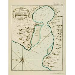
Plan du Cul de Sac des Roseaux dans l'Isle de Ste. Lucie.
This chart shows the territories of Cul de Sac des Roseaux on the island of Saint Lucie. The only issue of this version of Bellin's map, slightly larger than the common v...
Date: Paris 1764
Selling price: ????
Please login to see price!
Sold
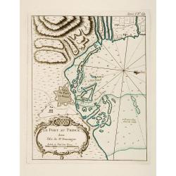
Plan du Port-au-Prince dans l'Isle de St Domingue.
This chart shows the territories of the town of Port-au-Prince on the island St Domingue.The only issue of this version of Bellin's map, slightly larger than the common v...
Date: Paris 1764
Selling price: ????
Please login to see price!
Sold
