Browse Listings in America > Caribbean & Atlantic Ocean > Puerto Rico
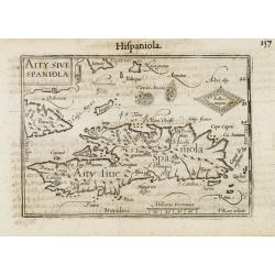
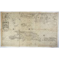
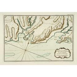
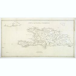
Aity Sive Spaniola.
General map of Hispaniola. Title cartouche on the upper left corner.First published in 1598 in his Caert-Thresoor, the plates were executed by the most famous engravers i...
Date: Amsterdam/Frankfurt 1609
Selling price: ????
Please login to see price!
Sold
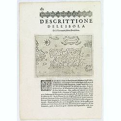
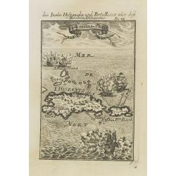
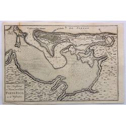
S.Giovanni. (Puerto Rico)
One of the earliest obtainable separate maps of Puerto Rico. Also shows the Virgin Islands, with a large St. Croix (Croce). Includes decorative cartouche, four sea monste...
Date: Venice, 1620
Selling price: ????
Please login to see price!
Sold in 2013
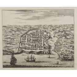
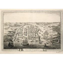
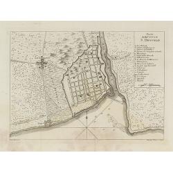
Urbs Domingo in Hispaniola.
Attractive bird's eye view of old Santo Domingo with the Cathedral, the Ozama fortress and other monuments clearly identifiable.
Date: Amsterdam, 1671
Selling price: ????
Please login to see price!
Sold
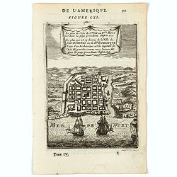
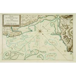
Le plan de l'Isle de St Jan de Pto. Rico . .
A charming plan of the city and harbour of San Juan, Puerto Rico.Title in curtain draped at top. French text on verso.From the original 1683 text edition of "Descrip...
Date: Paris, 1683
Selling price: ????
Please login to see price!
Sold in 2020
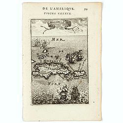
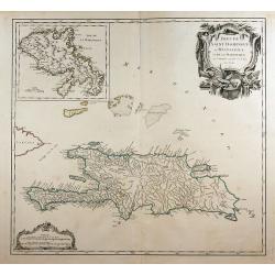
I. d'Hispagnola et Pto. Rico.
A charming map of Hispaniola and Puerto Rico. Title in curtain draped at top. French text on verso.From the original 1683 text edition of "Description d'Univers. . ....
Date: Paris, 1683
Selling price: ????
Please login to see price!
Sold in 2022
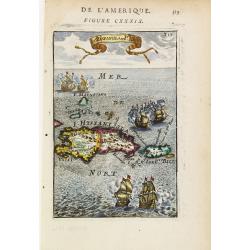
I.d\'Hispaniola et Pto Rico.
Peculiar map showing the islands of Hispaniola and Puerto Rico. The map is inserted in a prospective view of the Caribbean Sea, where some vessels are involved in a naval...
Date: Paris 1683
Selling price: ????
Please login to see price!
Sold
Le plan de.. La Ville de San Domingo où de St. Dominique..
Charming bird's-eye view of Santo Domingo. With vessels approaching the shore and entering the harbour.From the French text edition of Description d'Univers, 1683. by All...
Date: Paris 1683
Selling price: ????
Please login to see price!
Sold
I.d'Hispaniola et Pto Rico.
Map showing the islands of St. Domingo and Puerto Rico. The map is inserted in a prospective view of the Caribbean Sea, where some vessels are involved in a naval combat....
Date: Frankfurt, 1684
Selling price: ????
Please login to see price!
Sold in 2008
Nieuwe en Naaukeurige Paskaart van Het Eyland Hispaniola of St. Domingo met alle dresslss Havenen, Dieptens en Ankergronden, als meede de door passeeringe tusche de Caiques en andere Eylanden. naer de Opservatien van Monsr. Frezier. . .​
This rare magnificent large chart of Hispaniola and Puerto Rico was published by Johannes van Keulen II. The chart was compiled from the chart made by Amedee Francois Fre...
Date: Amsterdam, ca. 1742
Selling price: ????
Please login to see price!
Sold in 2018
Isles de Saint Domingue ou Hispaniola, ...
A large map of Santo Domingo, with an inset showing the island of Martinique.
Date: Paris, 1750
Selling price: ????
Please login to see price!
Sold in 2011
Ville de St. Domingue.
An attractive view of the town of St. Domingue.
Date: Paris, c. 1760
Selling price: ????
Please login to see price!
Sold
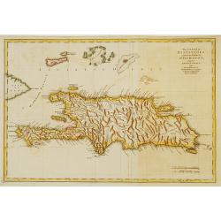
The island of Hispaniola called by the French St.Domingo..
The much contested island of Hispaniola at the height of the French side's prosperity, from Jeffery's The Natural and Civil History of the French Dominions in North and S...
Date: London 1760
Selling price: ????
Please login to see price!
Sold
Piano della Citta di S.Domingo.
An Italian edition of the Jeffery's plan of Santo Domingo city from the Gazzettiere Americano.
Date: Livorno, 1763
Selling price: ????
Please login to see price!
Sold in 2008
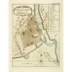
Ville de St. Domingue dans l'Isle de ce Nom.
This chart shows a plan of the city of Santo Domingo on the Dominican Republic. With a lettered key to the principal places in town.The only issue of this version of Bell...
Date: Paris 1764
Selling price: ????
Please login to see price!
Sold
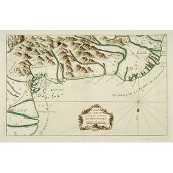
Environs de Leogane et du Port-au-Prince.
A highly detailed map of the area between Leogane and Port au Prince on Hispaniola, with a lovely decorative cartouche.The only issue of this version of Bellin's map, sli...
Date: Paris 1764
Selling price: ????
Please login to see price!
Sold
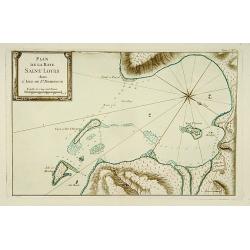
Plan de la Baye Saint Louis dans l'Isle de Saint Domingue.
This chart shows the Bay of Saint Louis on the island Saint-Domingue.The only issue of this version of Bellin's map, slightly larger than the common version. Depths shown...
Date: Paris 1764
Selling price: ????
Please login to see price!
Sold
Carte des Bayes Du Mesle des Flamands et de Cavaillon dans l'Isle de St Domingue.
This chart shows the south coast of St Domingo, with the bay area's of Bayes du Mesle des Flamands and Cavaillon.The only issue of this version of Bellin's map, slightly ...
Date: Paris 1764
Selling price: ????
Please login to see price!
Sold
Plan Du Port du Cap dans l'Isle de St. Domingue.
This chart shows the harbour of Cap on the island St-Domingue.The only issue of this version of Bellin's map, slightly larger than the common version. Depths shown by sou...
Date: Paris 1764
Selling price: ????
Please login to see price!
Sold
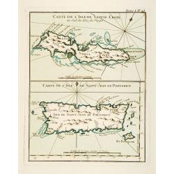
Carte de l'Isle de Sainte Croix au Sud des Isles des Vierges. / Carte de l'Isle de Saint Jean de Portorico.
This chart shows the islands of Sainte Croix and Isle Saint Jean de Porto Rico The only issue of this version of Bellin's map, slightly larger than the common version. De...
Date: Paris 1764
Selling price: ????
Please login to see price!
Sold
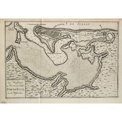
De Hoofdstad en Haven van 't Eiland Porto Rico in de Westindien.
Izaak Tirion (d. 1769) Amsterdam publisher. His 'Nieuwe en beknopte handatlas' saw 6 editions between before 1740 and after 1784. Also 'Tegenwoordige staat van alle volke...
Date: Amsterdam, 1765
Selling price: ????
Please login to see price!
Sold
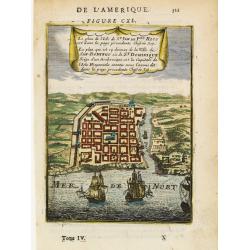
De Hoofdstad en Haven Van't Eiland Porto Rico, in de Westindien.
A detailed plan of San Juan Harbour in Puerto Rico, which appeared in Tirion's “Hedendaagsch Historie of Tegenwordige Staat van Amerika”.The map includes a detailed p...
Date: Amsterdam, 1765
Selling price: ????
Please login to see price!
Sold in 2023
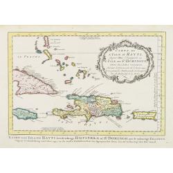
Carte de L'Isle d'Hayti, Aujour d'hui.. St.Domingue..
Uncommon edition of this fine map of Hispaniola and the neighboring islands Jamaica, Caymans, Porto Rico and eastern part of Cuba.Hispaniola divided into the five major c...
Date: Amsterdam, 1773
Selling price: ????
Please login to see price!
Sold
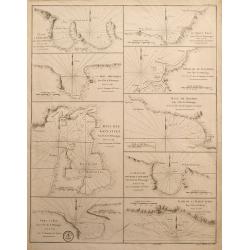
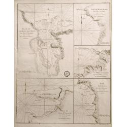
L'Anse a Chouchou; Le Port Paix; Mouillage de Jean- Rabel; La Baye Moustique; Baye de Tiburon; Baye des Gonayves; La Baye du Fond de la Grange; Port a l'Écu; rade de la Basse-Terre
Nine sea-charts on one sheet, showing various bays and harbors on Hispaniola and Tortuga. Engraved by Dela Haye for the Depot de la Marine. Each section shows depth sound...
Date: Paris, 1784
Selling price: ????
Please login to see price!
Sold in 2014
![L'Anse a Chouchou [with] Le Port Paix [with] Mouillage de Jean- Rabel [with] La Baye Moustique [with] Baye de Tiburon [with] Baye des Gonayves [with] La Baye du Fond de la Grange [with] Port a l'Écu [with] rade de la Basse-Terre. ( 9 plans).](/uploads/cache/36433-250x250.jpg)
L'Anse a Chouchou [with] Le Port Paix [with] Mouillage de Jean- Rabel [with] La Baye Moustique [with] Baye de Tiburon [with] Baye des Gonayves [with] La Baye du Fond de la Grange [with] Port a l'Écu [with] rade de la Basse-Terre. ( 9 plans).
Nine revolutionary war sea on one sheet, showing various bays and harbors on Hispaniola and Tortuga. Engraved by Dela Haye for the Depot de la Marine. Each section shows...
Date: Paris, 1784
Selling price: ????
Please login to see price!
Sold in 2020
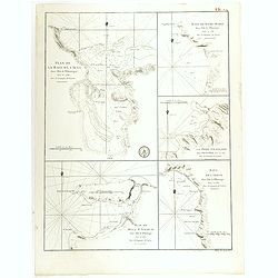
Plan de la Baye de l'Acul ( 5 plans on one sheet).
Revolutionary war sea chart with 5 plans of harbours at Santa Domingo in the Caribbean.Relief shown by hachures. Depths shown by soundings. Below engraved seal of Depot G...
Date: Paris, 1785
Selling price: ????
Please login to see price!
Sold in 2020
Plan de la Baye de l'Acul; Baye de Dame-Marie; Le Port François; Plan du Môle St. Nicolas; Baye des Irois
Five sea-charts on one large sheet. Engraved by Dela Haye for the Depot de la Marine. Each section shows depth soundings, anchoring places, and coastal information. A ra...
Date: Paris, 1787
Selling price: ????
Please login to see price!
Sold in 2014
A Map of the Island of St. Domingo.
An important map of the Caribbean island of St. Domingo (Santo Domingo), or Hispaniola, prepared by Bryan Edwards and published by Englishman John Stockdale in 1800. This...
Date: London, 1800
Selling price: ????
Please login to see price!
Sold in 2018
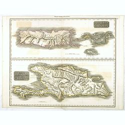
Porto Rico and Virgin Isles / Haiti, Hispaniola...
A map of three interesting West Indian Islands by the Edinburg cartographer John Thomson. Lightly hand colored. Relief shown by hachures.John Thomson was one of the leadi...
Date: Edinburgh, 1821
Selling price: ????
Please login to see price!
Sold in 2016
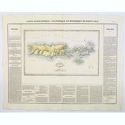
Carte Geographique, Statistique et Historique de Porto-Rico.
A nice detailed map of the island of Porto-Rico, and the Virgin Islands, from Buchon's Atlas Gégraphique Statistique, historique et chronologique des deux Ameriques et d...
Date: Paris, 1825
Selling price: ????
Please login to see price!
Sold in 2019
![[ Cotton preparation ].](/uploads/cache/27340-250x250.jpg)
[ Cotton preparation ].
Aquatint depicting cotton preparation.Engraved by Fumagalli.From Giulio Ferrario's work Le Costume Ancien et Moderne ou Histoire du gouvernement, de la milice, de la reli...
Date: Milan, 1827
Selling price: ????
Please login to see price!
Sold in 2020
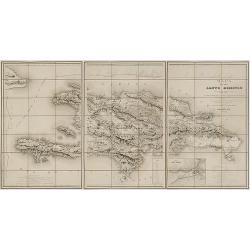
Mapa de la isla de Santo Domingo.
Impressive map of Saint Domingo. Includes indexed inset map of Santo Domingo 'Plan de la ciudad de Santo Domingo y de suyos contornos', distance tables and a coastal prof...
Date: Paris, 1858
Selling price: ????
Please login to see price!
Sold in 2017
