Browse Listings in America > Caribbean & Atlantic Ocean > Azores
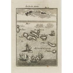
Açores Insulae.
The importance of the Azores at that time was connected with the observation of Columbus that compass variation (i.e. the difference between the real and the magnetic nor...
Date: Antwerp, 1580
Selling price: ????
Please login to see price!
Sold in 2015
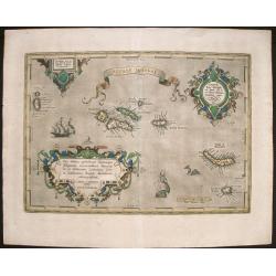
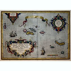
Açores Insulae. . .
Three cartouches of exceptional beauty decorate this artistic map. A beautifully engraved chart of the Azores based on Luis Teixeira's cartographic work with two ornate t...
Date: Antwerp, 1584
Selling price: ????
Please login to see price!
Sold in 2015
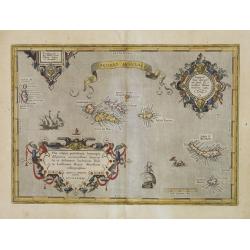
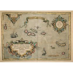
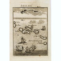
Açores Insulae.
First state. The importance of the Azores at that time was connected with the observation of Columbus that compass variation (i.e. the difference between the real and the...
Date: Antwerp, 1584
Selling price: ????
Please login to see price!
Sold in 2014
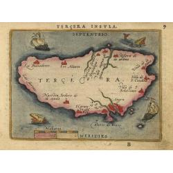
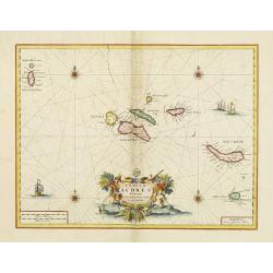
Tercera Insula
Nice miniature map showing the island and the important port of Angra. The map is beautifully engraved with stippled seas and two sailing ships and two tiny sea monsters.
Date: Antwerp, 1588
Selling price: ????
Please login to see price!
Sold
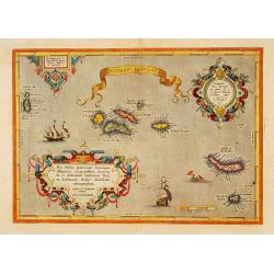
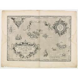
Acores Insulae.
Important map of Ortelius of the strategic islands of the Azores, in the 16th century an important hub from the Spanish Americas and the Silver fleet. The observation of ...
Date: Antwerp, 1592
Selling price: ????
Please login to see price!
Sold in 2018
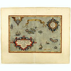
Açores Insulae.
The importance of the Azores at that time was connected with the observation of Columbus that compass variation (i.e. the difference between the real and the magnetic nor...
Date: Antwerp, 1592
Selling price: ????
Please login to see price!
Sold in 2009
Açores Insulae.
The importance of the Azores at that time was connected with the observation of Columbus that compass variation (i.e. the difference between the real and the magnetic nor...
Date: Antwerp, 1598
Selling price: ????
Please login to see price!
Sold in 2020
Açores Insulae.
The importance of the Azores at that time was connected with the observation of Columbus that compass variation (i.e. the difference between the real and the magnetic nor...
Date: Antwerp, 1598
Selling price: ????
Please login to see price!
Sold in 2019
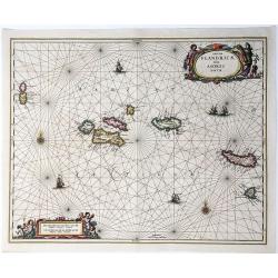
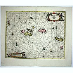
Insulae Flandricae, olim Asores dictae.
A scarce colored sea chart of part of the Atlantic Ocean: the Azores islands ((Faial, Pico, Graciosa, Terceira, Sao Jorge, Formigas, São Miguel), published by Johannes J...
Date: Amsterda, 1650
Selling price: ????
Please login to see price!
Sold in 2020
Insulae Açores delineante Ludovico Teisera.
Detailed map of the Azores, dedicated to L.Teisera. A later impression after which the copper plated suffered from several cracks, clearly visible on this strike. Includi...
Date: Amsterdam 1660
Selling price: ????
Please login to see price!
Sold
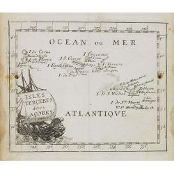
Isles Terceres dites Acores.
Uncommon miniature map of Azores from Pierre Duval's La Geographie Universeille dated 1676. Following his Cartes de geographie in 1657, Pierre Duval published this smalle...
Date: Paris, 1676
Selling price: ????
Please login to see price!
Sold in 2008
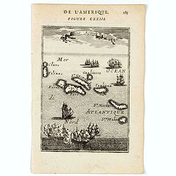
Isles Açores.
A charming map of Azores Islands. Title in curtain draped at top. French text on verso.From the original 1683 text edition of "Description d'Univers. . ." by Al...
Date: Paris, 1683
Selling price: ????
Please login to see price!
Sold in 2022
Isles Açores.
Charming map of the Azores inserted in a perspective view of the Atlantic ocean and embellished with fighting ships just off shores.From the French text edition of Descri...
Date: Paris 1683
Selling price: ????
Please login to see price!
Sold
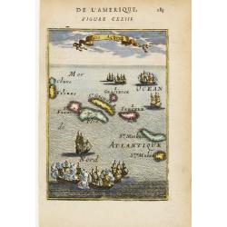
Isles Açores.
Charming map of the Azores islands shown in a perspective view of the Atlantic ocean and embellished with fighting ships just off shores.From the French text edition of D...
Date: Frankfurt, 1684
Selling price: ????
Please login to see price!
Sold in 2008
Isles Açores.
Charming map of the Azores islands shown in a perspective view of the Atlantic ocean and embellished with fighting ships just off shores.From the French text edition of D...
Date: Frankfurt, 1684
Selling price: ????
Please login to see price!
Sold in 2013
Insulae Flandricae olim Asores dictae.
Old map of the Azores, Including the island of Terceira. It was at the time an important port and administrative center of the island group. It is today the site of a U.S...
Date: Amsterdam, 1690
Selling price: ????
Please login to see price!
Sold in 2014
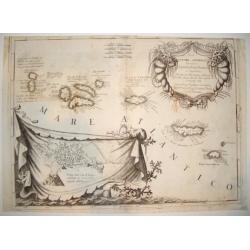
Isole Azzori, o Azzoridi dette altrimenti Acipitrum, Tertiae, Flandricae, et Superiores..
A beautiful and highly decorative map of the Azores Islands. With large title cartouche in the upper right corner decorated with coral, fish, seaweeds and pearl chains.In...
Date: Venice 1690
Selling price: ????
Please login to see price!
Sold
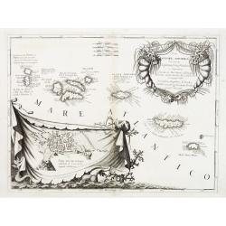
ISOLE AZZORI, O AZZORIDI...
This handsome, elaborate map of the Azores includes a detailed bird's-eye plan of Angra enclosed in an ornate, drape-style cartouche. Coastal towns are named. The beautif...
Date: Venice, c. 1690
Selling price: ????
Please login to see price!
Sold
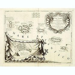
Isole Azzori, o Azzoridi. . .
A beautiful and highly decorative map of the Azores Islands. With large title cartouche in the upper right corner decorated with coral, fish, seaweeds and pearl chains.In...
Date: Venice, ca. 1696
Selling price: ????
Please login to see price!
Sold in 2014
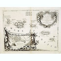
Isole Azzori, o Azzoridi. . .
A beautiful and highly decorative map of the Azores Islands. With large title cartouche in the upper right corner decorated with coral, fish, seaweeds and pearl chains.In...
Date: Venice, 1698
Selling price: ????
Please login to see price!
Sold in 2013
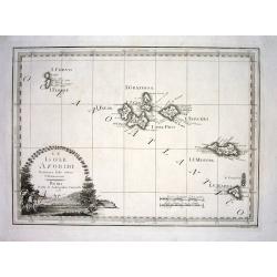
Carte des Isles d'Acores.
Uncommon and detailed map of the Azores.
Date: Amsterdam, 1730
Selling price: ????
Please login to see price!
Sold in 2015

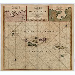
Carte des Isles d'Acores.
Uncommon and detailed map of the Azores. With inset maps of Port de St.Cruz and harbor and town of Angra on the island of Terceira. It was at the time an important port a...
Date: Amsterdam, 1730
Selling price: ????
Please login to see price!
Sold in 2024
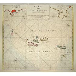
Carte des Isles d? Acores.
An uncommon and highly attractive map of the Azores. It contains much detail, with inset maps of Porto de Santa Cruz along with the town of Angra, located on the island o...
Date: Amsterdam, 1730
Selling price: ????
Please login to see price!
Sold
Carte Réduite des Isles Açores Pour servir aux Vaisseaux du Roy..
A well engraved and highly detailed chart. It shows soundings, anchorage's, channels, shoals, navigational sightings. Engraved by Petit, engraver for the Depot Générale...
Date: Paris, 1755
Selling price: ????
Please login to see price!
Sold in 2020
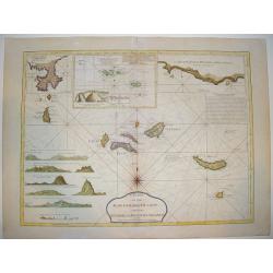
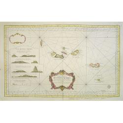
Chart of the Acores (Hawks) Islands, called also the Flemish and Western Islands
This is a fine, handsome nautical chart showing all the Azores islands with currents, rumb lines, anchorages, etc. Relief is shown by hachures, Includes 6 coastal profile...
Date: London, ca. 1794
Selling price: ????
Please login to see price!
Sold
Le Isole Azoridi delineate fulle ultime Osservazioni
Rare Italian map of the Azores. Large scale and very detailed with much of topographical information. Big and decorative title cartouche illustrating a native hunting sce...
Date: Rome, 1798
Selling price: ????
Please login to see price!
Sold
![Horta and Pim Bays / Fayal Channel [Azores].](/uploads/cache/43825-250x250.jpg)
Horta and Pim Bays / Fayal Channel [Azores].
Two charts on one sheet of Horta and Pim Bays and the Fayal Channel in the Azores in the Atlantic Ocean, originally published by the Hydrographic Office in 1849, but this...
Date: London, [1849] 1941
Selling price: ????
Please login to see price!
Sold in 2019
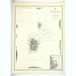
Azores. Corvo and Flores.
A large updated British Sea Chart from an original survey undertaken by Capt. A.T.E. Vidal, R.N. in 1844 of the islands of Corvo and Flores in the Azores Archipelago in t...
Date: London, 1946
Selling price: ????
Please login to see price!
Sold in 2023
