Browse Listings in America > Caribbean & Atlantic Ocean > Bermuda / Bahamas
![A Mapp of the Sommer Islands..[Mappa Aestivarum Insularum]..](/uploads/cache/15769-250x250.jpg)
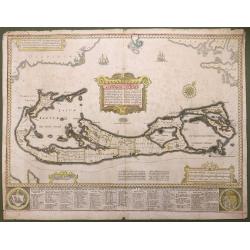
A Mapp of the Sommer Islands..[Mappa Aestivarum Insularum]..
Title in both English and Latin. English text on verso. The map was beautifully engraved by Abraham Goos in Amsterdam for Speed's Prospect Of The Most Famous Parts Of The...
Date: London 1626
Selling price: ????
Please login to see price!
Sold
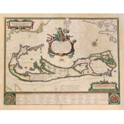
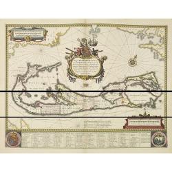
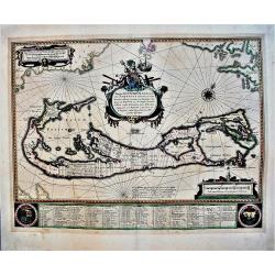
Mappa Aestivarum Insularum, Alias Barmudas. . .
Map is based on the survey by John Norwood of the Bermuda Company in 1618 and it shows the division into the original eight tribes and shows the various landowners, with ...
Date: Amsterdam, 1631
Selling price: ????
Please login to see price!
Sold in 2011
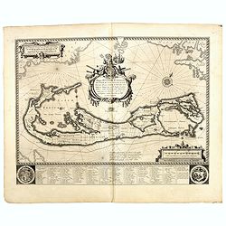
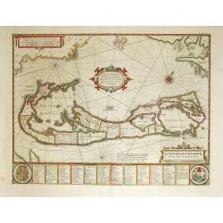
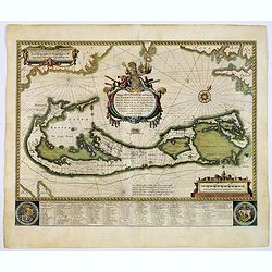
Mappa Aestivarum Insularum alias Barmudas.
Blaeu based his work on John Speed's remarkably accurate map of 1626-1627. It shows the island divided into eight tribes and lots, and below the map itself appear the nam...
Date: Amsterdam, 1634
Selling price: ????
Please login to see price!
Sold in 2015
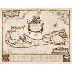
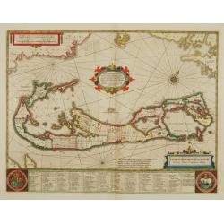
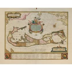
Mappa Aestivarum Insularum alias Barmudas.
Blaeu based his work on John Speed's remarkably accurate map of 1626-1627. It shows the island divided into tribes and lots, and below the map itself appear the names of ...
Date: Amsterdam 1635
Selling price: ????
Please login to see price!
Sold
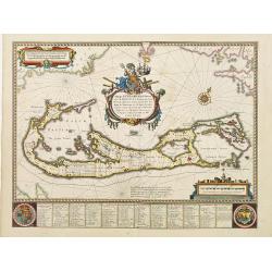
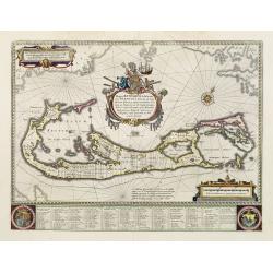
Mappa Aestivarum Insularum alias Barmudas.
Blaeu based his work on John Speed's remarkably accurate map of 1626-1627. It shows the island divided into tribes and lots, and below the map itself appear the names of ...
Date: Amsterdam 1635
Selling price: ????
Please login to see price!
Sold
Mappa Aestivarum Insularum alias Barmudas.
Blaeu based his work on John Speed's remarkably accurate map of 1626-1627. It shows the island divided into tribes and lots, and below the map itself appear the names of ...
Date: Amsterdam, 1638
Selling price: ????
Please login to see price!
Sold in 2015
Mappa Aestivarum Insularum, alias Barmudas Dictarum.
A striking map based on the famous survey by Richard Norwood of the Bermuda Company, also known as the Somers Isles Company in 1618. The map shows the division into the o...
Date: Amsterdam, ca.1647
Selling price: ????
Please login to see price!
Sold in 2014
Mappa Aestivarum Insularum, alias Barmudas..
This magnificent map is based on the famous survey by John Norwood of the Bermuda Company in 1618. The map shows the division into the original Tribes and shows the vario...
Date: Amsterdam 1646-1657
Selling price: ????
Please login to see price!
Sold
Mappa Aestivarum Insularum alias Barmudas.
Blaeu based his work on John Speed's remarkably accurate map of 1626-1627. It shows the island divided into tribes and lots, and below the map itself appear the names of ...
Date: Amsterdam, 1658
Selling price: ????
Please login to see price!
Sold in 2008
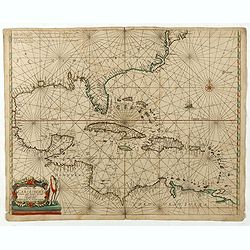
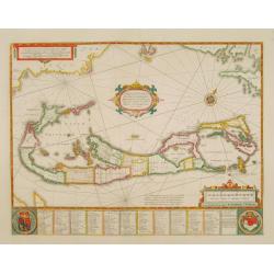
Pascaerte vande Caribische Eylanden, vande Barbados tot aende Bocht van Mexico ‘t Amsterdam By Hendrick Doncker. . .
First state. Rare. “This chart appeared in the first edition of Hendrick Doncker’s Zee-Atlas, of which no surviving example is known” -- Burden. This is an example of the...
Date: Amsterdam, 1659
Selling price: ????
Please login to see price!
Sold in 2020
Mappa Aestivarum Insularum alias Barmudas.
An early, large, decorative map of the Bermudas by Blaeu, who based his map on the work of English cartographer John Speed, who produced a remarkably accurate map between...
Date: Amsterdam, 1662
Selling price: ????
Please login to see price!
Sold in 2021
Mappa Aestivarum Insularum alias Barmudas.
Blaeu based his work on John Speed's remarkably accurate map of 1626-1627. It shows the island divided into tribes and lots, and below the map itself appear the names of ...
Date: Amsterdam, 1662
Selling price: ????
Please login to see price!
Sold in 2017
Mappa Aestivarum Insularum, alias Barmudas...
From the first edition of the last part of the Latin "Atlas maior" dedicated to America.Blaeu based his work on John Speed's remarkably accurate map of 1626-162...
Date: Amsterdam, 1662
Selling price: ????
Please login to see price!
Sold in 2010
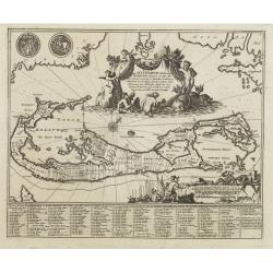
Aestivarum Insularum alias Bermudas...
This beautiful map was compiled in 1622 by Richard Norwood. It’s the first English printed map published in an atlas to show Bermuda divided into Tribes and Shares. These...
Date: London, 1676
Selling price: ????
Please login to see price!
Sold in 2016
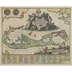
Mappa Aestivarum Insularum alias Barmudas..
A very decorative map. The large title cartouche shows Neptune with mermaids and a sea-monster.The map includes the arms of England and Bermuda, and lists proprietors of ...
Date: Amsterdam, 1680
Selling price: ????
Please login to see price!
Sold in 2008
Mappa Aestivarum Insularum alias Barmudas. . .
A very decorative map. The large title cartouche shows Neptune with mermaids and a sea-monster.The map includes the arms of England and Bermuda, and lists proprietors of ...
Date: Amsterdam, 1680
Selling price: ????
Please login to see price!
Sold
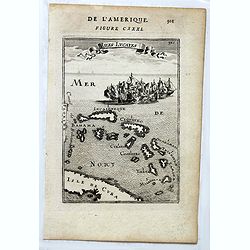
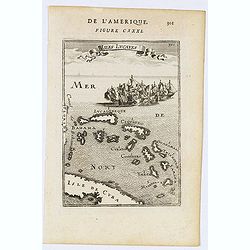
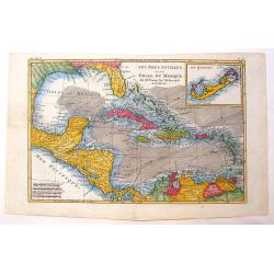
Isles Lucayes.
Fine map showing the Bahamas. The map is inserted in a prospective view of the Caribbean Sea, where some vessels are involved in a naval combat. Part of Cuba and Florida ...
Date: Paris, 1683
Selling price: ????
Please login to see price!
Sold in 2018
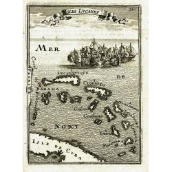
Isles Lucayes.
Fine map showing the Bahamas. The map is inserted in a prospective view of the Caribbean Sea, where some vessels are involved in a naval combat. Part of Cuba and Florida ...
Date: Paris, 1683
Selling price: ????
Please login to see price!
Sold in 2014
Mappa Aestivarum Insularum alias Barmudas. . .
A very decorative map. The large title cartouche shows Neptune with mermaids and a sea-monster.The map includes the arms of England and Bermuda, and lists proprietors of ...
Date: Amsterdam, 1683
Selling price: ????
Please login to see price!
Sold
ISLES LUCAYES
Interesting map of the Bahamas from Mallet\'s famous Description d\'Univers published in 1683. Shows parts of Cuba and Florida, and the islands of the Bahamas with their ...
Date: Paris, 1683
Selling price: ????
Please login to see price!
Sold in 2009
Isles Lucayes.
A charming map of The Bahamas with the east coast of Florida on the left hand side of the map. Part of Cuba is shown at the bottom of the map. Title in curtain draped at ...
Date: Paris, 1683
Selling price: ????
Please login to see price!
Sold in 2020
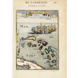
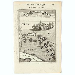
Isles Lucayes.
Peculiar map showing the Bahamas. The map is inserted in a prospective view of the Caribbean Sea, where some vessels are involved in a naval combat. Part of Cuba and Flor...
Date: Paris 1683
Selling price: ????
Please login to see price!
Sold
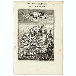
Gyanahani ou St. Sa...
A charming map of Guanahani Island, San Salvador in The Bahamas. Title in curtain draped at top. French text on verso.From the original 1683 text edition of "Descrip...
Date: Paris, 1683
Selling price: ????
Please login to see price!
Sold in 2022
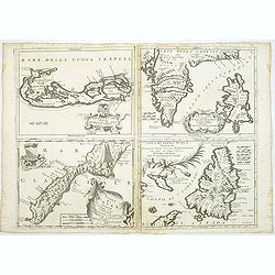
Le Bermude / Frislanda / Isola di Mayen / Isola di Terra Nuova.
Four maps printed on one large sheet, each from a separate copper plate. The remarkable Vincenzo Coronelli (1650-1718), encyclopaedist, geographer, inventor and Doctor of...
Date: Venice, 1696
Selling price: ????
Please login to see price!
Sold
Le Bermude, Dedicate All'Illusstrissimo Sig:r Abbate Isidoro Bernardi.
Fine map of Bermuda with the title cartouche incorporating a the cardinal’s arms beneath, this map occurred in an atlas called ‘Corso Geographico Universale’.The remarkab...
Date: Venice, 1696
Selling price: ????
Please login to see price!
Sold in 2014
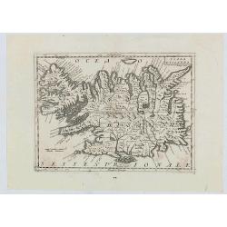
Isola d'Islanda
The map is a reduced copy of Joris Carolus', but the forms of the names and other features suggest that the model was the version by Johannes Janssonius rather than that ...
Date: Venice, 1697
Selling price: ????
Please login to see price!
Sold in 2020
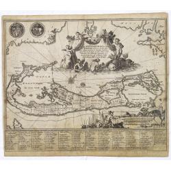
Mappa Aestivarum Insularum, alias Barmudas..
The map is the rare re-issue of the Blaeu's copperplate of 1630. The map includes the arms of Bermuda and England, and lists proprietors of the various tribes into which ...
Date: Amsterdam 1720
Selling price: ????
Please login to see price!
Sold
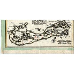
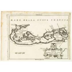
Insulae Bermudes in suas Tribus divisae...
Copper-engraved map of Bermuda most probably from a larger Homann composite sheet showing also other islands. Shows the island in good detail, naming towns and villages, ...
Date: Nuremberg, c1730
Selling price: ????
Please login to see price!
Sold in 2011
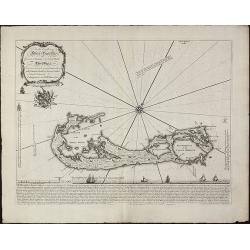
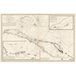
To his Excellency Alured Popple Esq. Governour of Bermuda, or the Summer Islands. This Map.
Important and exceptional rare sea chart of the Bermuda IslandsClement Lempriere's chart of Bermuda, published in 1738, was the next major advance after Arent Roggeveen c...
Date: London, 1738
Selling price: ????
Please login to see price!
Sold in 2010
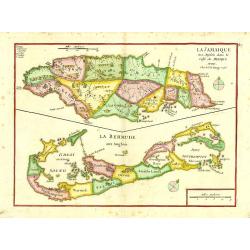
La Jamaique..Golfe du Mexique/ La Bermude.
"Two maps on one sheet; Jamaica and Bermuda. George Louis Le Rouge was active from 1740- till 1780 as a publisher, and was appointed engineer for the King of France....
Date: Paris 1748
Selling price: ????
Please login to see price!
Sold
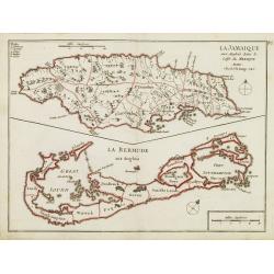
La Jamaique.. La Bermude..
Two maps on one sheet, Jamaica above Bermuda. Jamaica is engraved to show the plantations, denoting those growing sugar, cotton, cacao, and indigo. The map of Bermuda inc...
Date: Paris 1756
Selling price: ????
Please login to see price!
Sold
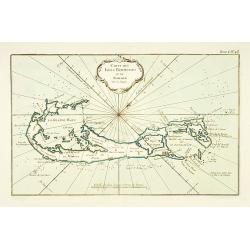
Carte des Isles Bermudes ou de Sommer.
This chart shows the island of Bermuda.The only issue of this version of Bellin's map, slightly larger than the common version. Depths shown by soundings.From Bellin's Pe...
Date: Paris 1764
Selling price: ????
Please login to see price!
Sold
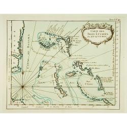
Carte des Isles Lucayes.
This chart shows the territories of the Bahamas, and the East coast of southern Florida. The only issue of this version of Bellin's map, slightly larger than the common v...
Date: Paris 1764
Selling price: ????
Please login to see price!
Sold
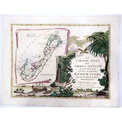
LE COLONIE UNITE dell' AMERICA SETTENTRle di nuova projezione assee li signori. . . (Title Page and Bermuda)
A striking, beautifull, title page of Zatta's twelve sheet monumental work, with inset showing the island of Bermuda. This map is a part of the Italian edition of John Mi...
Date: Venice, 1778
Selling price: ????
Please login to see price!
Sold in 2020
Les Isles Antilles et le Golfe du Mexique.
A beautiful colored map of the Gulf of Mexico with an inset map of Bermuda Island. From "Atlas de Toutes les Parties Connues du Globe Terrestre". Detailed with ...
Date: Paris - 1780
Selling price: ????
Please login to see price!
Sold in 2013
Carte Reduite d’une partie du Vieux Canal de Bahama...
This large highly detailed chart of the northern coastline of Cuba and part of the Bahamas was published under the auspices of the Contra-Amiral Decres Ministre de la Mar...
Date: Paris, 1801
Selling price: ????
Please login to see price!
Sold in 2023
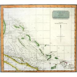
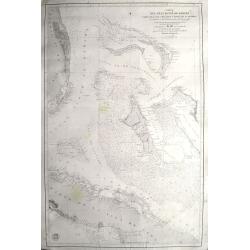
CHART OF THE BAHAMA ISLANDS
Rare chart of the Bahamas, includgin part of Cuba and the Turks & Caicos. Excellent detail with depth soundings and shipping channels indicated. On of the best maps a...
Date: Edinburgh, 1816
Selling price: ????
Please login to see price!
Sold
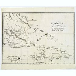
Map of the Route of Columbus, on arriving among the Bahama Islands.
An interesting map of the route Christopher Columbus took when he arrived in the Bahamas. Map extent includes Jamaica, most of Cuba, Saint Domingo, The Caycos Islands, th...
Date: Philadelphia, 1820
Selling price: ????
Please login to see price!
Sold in 2018
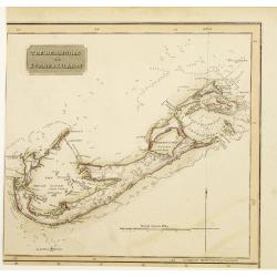
The Bermudas or Summer Islands.
Somewhat later but very finely engraved and detailed map, including roads, of Bermuda. Part from a sheet with other maps of Cuba and the Bahamas, from the east coast of F...
Date: Edinburgh 1829
Selling price: ????
Please login to see price!
Sold
Carta del gran banco de Bahama parte de la isla de Cuba y costa de la Florida.
A scarce chart of the Bahamas, from Grand Bahama to Cuba and from Florida to the Exumas. In Florida it shows Fort Jupiter, Boca Raton, Miami, Jessup, Fort Lauderdale, etc...
Date: Madrid, 1866
Selling price: ????
Please login to see price!
Sold in 2020
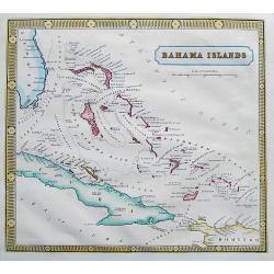
Bahama Islands.
A scarce and very detailed map of the Bahamas, including a part of Florida, Cuba, and Hispaniola. Map shows many islands, shoals and rocks. Names also the Hole in the Wal...
Date: ca. 1870
Selling price: ????
Please login to see price!
Sold in 2017
![[ATLAS] Maps of the Bahama Islands with statics and index.](/uploads/cache/37319-250x250.jpg)
[ATLAS] Maps of the Bahama Islands with statics and index.
A rare atlas of the Bahama Islands published by the official authorities. Illustrated with 20 maps, followed 6 pages index. In the introduction the number of 53,000 inhab...
Date: London, Stanford's geog. Establ., 1926
Selling price: ????
Please login to see price!
Sold in 2019
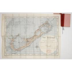
Map of the Bermudas. Compiled from Ordnance Survey Map of 1902, & Admiralty Chart. (1900) Geographical Section. General. Staff. No.3951. Fridded and Railways added 1933. . .
A scarce map of the Bermuda's, compiled from Ordnance Survey Map of 1902, with red grid system and railways added 1933. Scale two inches to one Statute Mile.
Date: London, War Office. 1933
Selling price: ????
Please login to see price!
Sold in 2017
