Browse Listings in America > Caribbean & Atlantic Ocean > Windwards / Leewards / Guadeloupe
![[The English are attacked on St. Lucia.]](/uploads/cache/40366-250x250.jpg)
[The English are attacked on St. Lucia.]
During Oliver Leagh’s voyage to Guiana in 1605, Captain St. John went ashore with a number of the crew. There they built a settlement by the sea and for some weeks trad...
Date: Frankfurt, M.Merian, 1633
Selling price: ????
Please login to see price!
Sold in 2017
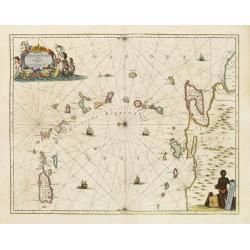
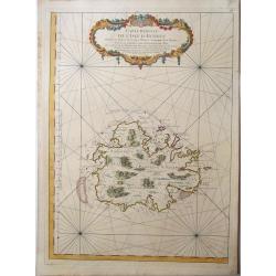
Insula S.Iuan de Puertorico caribes vel Canibasun insulae.
Interesting map of the Lesser Antilles, from Porto Rico as far as Trinidad & Tobago and the South American coast. North is orientated to the left of the page.With a s...
Date: Amsterdam 1650
Selling price: ????
Please login to see price!
Sold

De Stadt St. Martin.
A view of the town of St. Maarten on the island St.-Martin/St. Maarten with a Dutch fleet in the foreground. Title ribbon in the sky, letter key in the upper right corner...
Date: Amsterdam, 1671
Selling price: ????
Please login to see price!
Sold
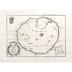
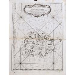
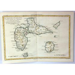
Isola di Maria Galante nell Antilli. . .
One of the few separate maps of the island of Marie Galante, showing sugar plantations, and (curiously) some large trees. Fort Moliere is shown in a small inset. Small pe...
Date: Venice, ca. 1690
Selling price: ????
Please login to see price!
Sold in 2018
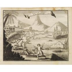
Surprise des INDIENS de la Guardeloupe..
Interesting print depicting the arrival of Europeans in Guadeloupe.From the book Nouvelle Relation, Contenant LES VOYAGES DE THOMAS GAGE dans la nouvelle Espagne [..] jus...
Date: Amsterdam 1722
Selling price: ????
Please login to see price!
Sold
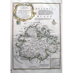
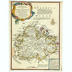
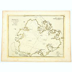
A New and Accurate Map of the Island of Antigua or Antego...
Highly attractive map of Antigua. Very detailed map with many place names, streets, etc. With text describing the island and a legend explaining symbols to churches, for...
Date: London, 1747
Selling price: ????
Please login to see price!
Sold in 2012
A New and Accurate Map of the Island of Antigua or Antego. . .
Bowen's maps of Antigua from A Complete System of Geography.. Decorated with a compass rose and a title cartouche. With extensive details and interesting annotations abou...
Date: London, 1747
Selling price: ????
Please login to see price!
Sold in 2023
Carte de l?Isle de St. Christofle.
Jaques Nicolas Bellin (1702-720) was the most important French hydrographer of the 18th century. Sea-atlas 'Hydrographique Français' , 1756-65, atlas to accompany Prévo...
Date: Paris, c.1755
Selling price: ????
Please login to see price!
Sold
Carte réduite de l'isle d'Antigue
Large and detailed chart of Antigua. One of the best 18th Century maps of the island. Shows villages, windmills, hills, streets, Parishes, bays, anchorages, depth soundin...
Date: Paris, 1758
Selling price: ????
Please login to see price!
Sold in 2022
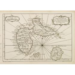
Carte de L'Isle de la Guadeloupe.
A good engraved map of Guadeloupe. The geographical features are typical with somewhat exaggerated bays and inlets. From l'Histoire générale des voyages .
Date: Paris 1758
Selling price: ????
Please login to see price!
Sold
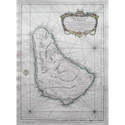
Carte de l'Isle de la Barbade dressee au Depost des Cartes et Plans de la Marine...
Bellin's famous large scale map of Barbados - one of the best antique maps of the island, with many details such as parishes, villages, churches, streets, anchorages, sho...
Date: Paris, 1758
Selling price: ????
Please login to see price!
Sold in 2016
ANTIGUA, - Carte reduite de l'isle d'Antigue ; dressée au Dépost des cartes, plans et journaux de la marine : pour le service des vaisseaux du roy. . .
A very rare and large nautical map of the island of Antigua, by Bellin, at Dépost des cartes, plans et journaux de la marine. Relief shown pictorially. Depths by soundin...
Date: Paris, 1758
Selling price: ????
Please login to see price!
Sold in 2022
Guadeloupe, one of the Caribee Islands in the West Indies from the latest Discovery.
Guadeloupe, one of the Caribee Islands in the West Indies from the latest Discovery. By John Hinton. Published in London March 1759, in "The Universal Magazine of Kn...
Date: London 1759
Selling price: ????
Please login to see price!
Sold in 2015
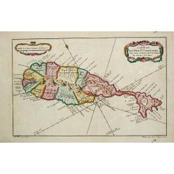
Carte Reduite des Isles de la Guadeloupe Marie Galante et les Saintes..
Superb large-scale sea chart with great detail of parishes, forts, towns, settlements, anchorages and topography. Includes Guadeloupe, Isles de Saintes and Marie Galante ...
Date: Paris 1760
Selling price: ????
Please login to see price!
Sold in 2008
![[A lot of 5 map of Guyana.] Land-kaart van Cayenne.](/uploads/cache/20452-250x250.jpg)
[A lot of 5 map of Guyana.] Land-kaart van Cayenne.
An attractive map of the island and settlement of Cayenne, with an inset picturing a plan of the town and fort of Cayenne. Izaak Tirion (d. 1769) Amsterdam publisher. H...
Date: Amsterdam, c. 1760
Selling price: ????
Please login to see price!
Sold in 2022
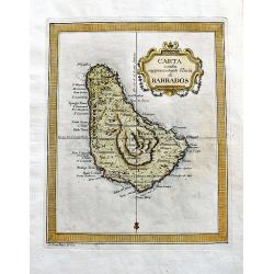
Carta esatta rappresentante l'isola di Barbados.
A fine map of Barbados published in the "Gazzetiere Americano". Engraved by V. Rossi. In nice and decorative colors, and in good condition!
Date: Livorno, 1763
Selling price: ????
Please login to see price!
Sold in 2020
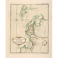
Environs du Fort Louis de la Guadeloupe.
This chart shows the territories around Fort Louis on the island of Guadeloupe The only issue of this version of Bellin's map, slightly larger than the common version. De...
Date: Paris 1764
Selling price: ????
Please login to see price!
Sold
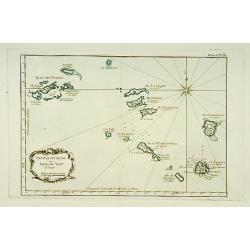
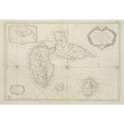
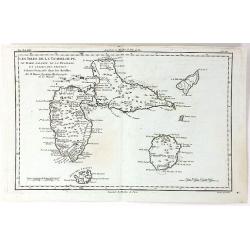
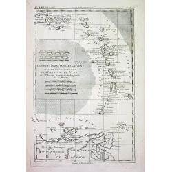
Petites Antilles ou Isle du Vent.. 3ème. Partie.
This chart shows The Windward Islands from the Virgin Islands to Antigua.The only issue of this version of Bellin's map, slightly larger than the common version. Depths s...
Date: Paris 1764
Selling price: ????
Please login to see price!
Sold
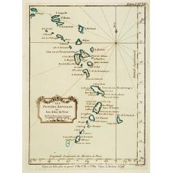
Les Petites Antilles ou Les Isles du Vent.
This chart shows the territories of the smaller Antilles or Windward islands.The only issue of this version of Bellin's map, slightly larger than the common version. Dept...
Date: Paris 1764
Selling price: ????
Please login to see price!
Sold
Antigue une des Antilles aux Anglois.
A map of Antigua in the Caribbean published in Paris by Jean Baptist Crepy in the mid eighteenth century. The map shows roads criss-crossing the island, with parishes, vi...
Date: Paris, 1767
Selling price: ????
Please login to see price!
Sold in 2023
Les Isles de la Guadeloupe, de Marie Galante, de la Désirade et Celles des Saintes...
A map of the French island of Guadeloupe, together with the islands in the vicinity, by Bonne, published in Paris in 1774. Engraved by Dien.Rigobert Bonne (1727-1795), wa...
Date: Paris, 1774
Selling price: ????
Please login to see price!
Sold in 2020
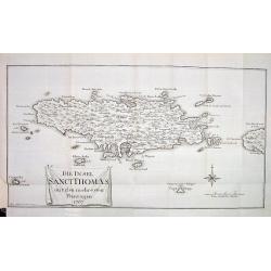
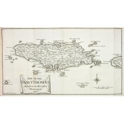
DIE INSEL SANCT THOMAS mit den mehresten Plantagen 1767
Very rare and sought after map of the Island of St. Thomas, US Virgin Islands. Although dated 1767 it was published in 1777 in Oldendorp's "Geschichte der Mission de...
Date: Nuremberg, 1777
Selling price: ????
Please login to see price!
Sold
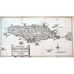
Die Insel Sanct Thomas mit den mehresten Plantagen 1767.
A rare and sought after map of the Island of St. Thomas, US Virgin Islands. Although dated 1767 it was published in 1777 in Oldendorp's "Geschichte der Mission der e...
Date: Nuremberg, 1777
Selling price: ????
Please login to see price!
Sold in 2018
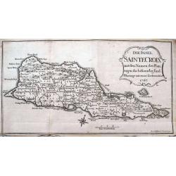
Die Insel Sainte Croix mit den Namen der Plantagen die bestaendig sind.
Very rare and sought after map of the Island of St. Croix (Santa Cruz), one of the US Virgin Islands. Although dated 1767 this it was published in 1777 in Oldendorp's &qu...
Date: Nuremberg, 1777
Selling price: ????
Please login to see price!
Sold in 2022
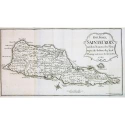
Die Insel SAINTE CROIX mit den Namen der Plan...
Very rare map of the Island of St. Croix (Santa Cruz), one of the US Virgin Islands. Although dated 1767 this it was published in 1777 in Oldendorp's "Geschichte der...
Date: Nuremberg, 1777
Selling price: ????
Please login to see price!
Sold
Die Insel Sanct Thomas mit den mehresten Plantagen 1767
Very rare map of the Island of St. Thomas, US Virgin Islands. Although dated 1767 this it was published in 1777 in Oldendorp's "Geschichte der Mission der evangelisc...
Date: Nuremberg, 1777
Selling price: ????
Please login to see price!
Sold
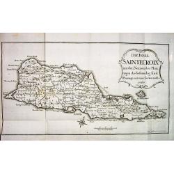
DIE INSEL SAINTE CROIX mit den Namen der Plantagen die bestaendig sind.
Very rare and sought after map of the Island of St. Croix (Santa Cruz), one of the US Virgin Islands. Although dated 1767 this it was published in 1777 in Oldendorp's &qu...
Date: Nuremberg, 1777
Selling price: ????
Please login to see price!
Sold
CARTE DES ISLES ANTILLES ou du VENT AVEC LA PARTIE ORIENTALE DES ISLES SOUS LE VENT
Beautiful and detailed copper-engraved map the lesser Antilles, from Puerto Rico to the coast of Venezuela. The map bears seven distance scales. From "Atlas de toute...
Date: Paris, c1780
Selling price: ????
Please login to see price!
Sold
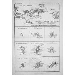
SUPPLÉMENT POUR LES ISLES ANTILLES, EXTRAIT DES CARTES ANGLOISES...
Beautiful and detailed copper-engraved map with excellent detail on the Virgin Islands + 9 inset maps of: Barbuda, St. Kitts, Antigua, Dominica, St. Lucia, Barbados, St. ...
Date: Paris, c1780
Selling price: ????
Please login to see price!
Sold
Les Isles de la Guadeloupe de Marei Galante, de la Desirade et Celles des Saintes.
A map of the French island of Guadeloupe with the islands in the vicinity. Many towns and forts are named, and some topographical details (mountains, rivers, lakes...), a...
Date: Paris, 1780
Selling price: ????
Please login to see price!
Sold in 2019
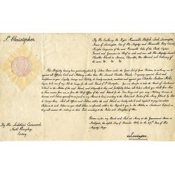
(St. Kitts) Appointment of Charles Andrew Mills as the Aid-de-Camp. . .
Unique and rare document: Describes the appointment of Charles Andrew Mills as the Aid-de-Camp (ADC and government representative) of the Caribbean island of St. Christ...
Date: Antigua, 1806
Selling price: ????
Please login to see price!
Sold in 2016
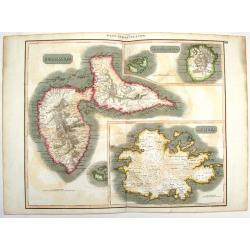
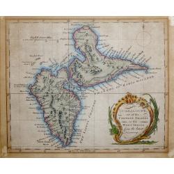
West Indies Islands - Guadeloupe, Mariegalante & Antigua.
A fine Thomson map of the West Indies islands of Guadeloupe, Mariegalante and Antigua. The map is simple, clean and elegant. John Thomson (1777-c1840), was a Scottish ca...
Date: Edinburgh, 1817
Selling price: ????
Please login to see price!
Sold in 2015
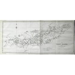
The Virgin Islands, shewing The Set of The Tide amongst them. . .
Highly important lithograph map of the Virgin Islands, published by John Murray. Extending from Green and Brigantine Islands just east of St. Thomas to Virgin Gorda in th...
Date: London, 1835
Selling price: ????
Please login to see price!
Sold in 2011
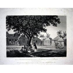
VUE DE L'ETABLISSEMENT DES MISSIONS À ST. JOHNS DANS L'ISLE D'ANTIGOA AUX INDES ORIENTALES
Extremely rare and important aquatint view of Antigua! Based on original works by L. Stobwasser, engraved by Franz Hegi. Illustrates a scene of island life with slaves ...
Date: Basle, 1835
Selling price: ????
Please login to see price!
Sold in 2009

Vue de Gracehill dans l'Isle d'Antigoa...
Extremely rare and important aquatint view of Antigua!Based on original works by L. Stobwasser, engraved by Hürlimann.Illustrates a scene of island life at the Gracehill...
Date: Basle, 1835
Selling price: ????
Please login to see price!
Sold in 2009
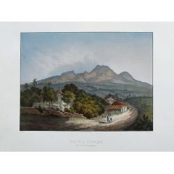
Vue de la Souffrière prise de Versailles (Guadeloupe).
A fantastic view of the Soufrière volcano ,taken from the rare and important series La Guadeloupe pittoresque by Armand Budan, published in 1863. Lithograph by Emile Ver...
Date: Paris, 1863
Selling price: ????
Please login to see price!
Sold in 2020
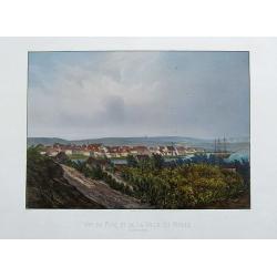
Vue du port et de la ville du Moule.
A fantastic view of Le Moule, from the rare and important series La Guadeloupe pittoresque by Armand Budan, published in 1863. Lithograph by Emile Vernier, and printed by...
Date: Paris, 1863
Selling price: ????
Please login to see price!
Sold in 2020
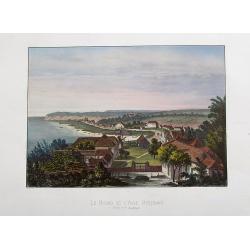
Le Bourg de L'Anse Bertrand. Grand Terre (Guadeloupe).
A fantastic view of Anse-Bertrand, from the rare and important series La Guadeloupe pittoresque by Armand Budan, published in 1863. Lithograph by Emile Vernier, and print...
Date: Paris, 1863
Selling price: ????
Please login to see price!
Sold in 2020
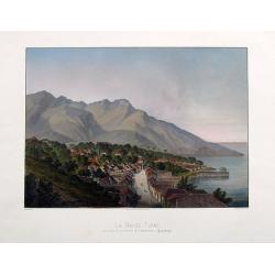
La Basse-Terre, vue prise de la Batterie de l'Impératrice, (Guadeloupe).
A fantastic view of the town from the rare and important series La Guadeloupe pittoresque by Armand Budan, published in 1863. Lithograph by Emile Vernier, and printed by...
Date: Paris, 1863
Selling price: ????
Please login to see price!
Sold in 2017
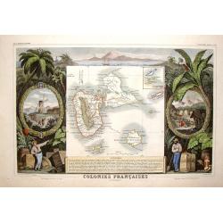
Colonies Francais en Amerique - Guadaloupe & St. Martin's.
Beautiful map of the Caribbean Islands of Guadeloupe and Grande Terre. The map is surrounded by several elaborate decorative engravings designed to illustrate the richnes...
Date: Paris, 1882
Selling price: ????
Please login to see price!
Sold in 2015
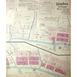
Kingston, St. Vincent. West Indies.
Large, uncommon fire insurance plan is presented on a scale of 120 feet to one inch. Lists the town with a population of 6000, from which 1/12 is white. Explains the main...
Date: Montreal/Toronto, 1897
Selling price: ????
Please login to see price!
Sold in 2014
