Browse Listings in America > Caribbean & Atlantic Ocean > Martinique
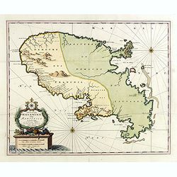
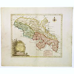
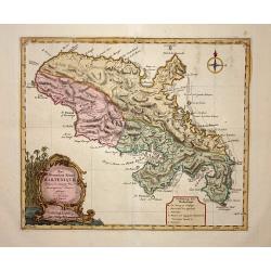
Insula Matanino vulgo Martanico in lucem edita / per Nicolaum Visscher cum Priviliegio Ordin: General Belgii Faederati.
Uncommon map, showing the portion of the island which had been taken from the Caribs up to that time. In lower left corner a title cartouche with fruit, tobacco, sugar.
Date: Amsterdam, ca. 1680
Selling price: ????
Please login to see price!
Sold in 2019
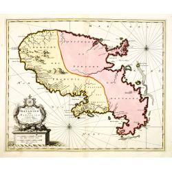
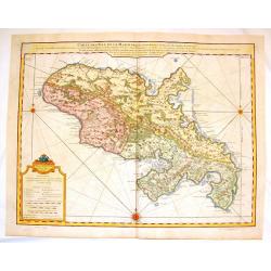
Insula Matanino vulgo Martanico in lucem edita / per Nicolaum Visscher cum Priviliegio Ordin: General Belgii Faederati.
Uncommon map, showing the portion of the island which had been taken from the Caribs up to that time. In lower left corner a title cartouche with fruit, tobacco, sugar.
Date: Amsterdam, ca. 1680
Selling price: ????
Please login to see price!
Sold
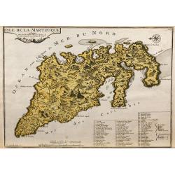
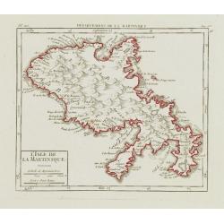
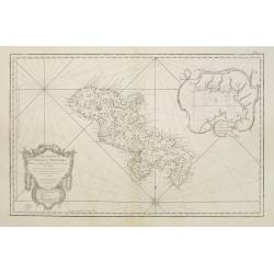
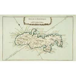
L'Isle de la Martinique.
Map of the island of Martinique, engraved by F.Starckman, from De Fer's Atlas Curieux.
Date: Paris, 1704
Selling price: ????
Please login to see price!
Sold in 2009
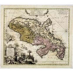
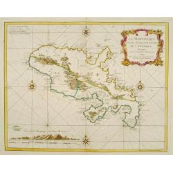
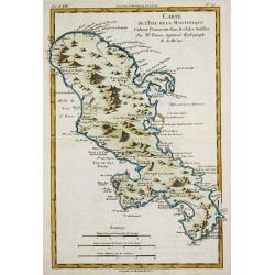
Representation la plus nouvelle et exacte De L'Ile Martinique, la premiere des Iles Del' Amerique Antilles Nommees Barlovento, Aux depens...
Fine map of Martinique with an extremely decorative cartouche that depicts the native islanders meeting and trading with Europeans. Engraved by Albrecht Carl Seutter (172...
Date: Augsburg, c. 1740
Selling price: ????
Please login to see price!
Sold
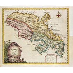
Carte de L' Isle de la Martinique Colonie Francoise de l'une des Isles Antilles de l'Amerique..
A very well executed plan of the island after Delisle. Excellent detail throughout includes realistic depictions of bays, mountains, islets, lagoons, forests, etc., which...
Date: Amsterdam c. 1745
Selling price: ????
Please login to see price!
Sold
La Martinique une des Antilles Françoises de L'Amerique..
Fine map of Martinique. George Louis Le Rouge was active from 1740- till 1780 as a publisher, and was appointed engineer for the King of France.
Date: Paris 1748
Selling price: ????
Please login to see price!
Sold
L\'Isle de la Martinique.
Nice small map of Martinique. From Atlas Portatif Universel, by Robert de Vaugondy.Page 563 and 96 outside border top right. To the left Pl. 110.Mary Sponberg Pedley does...
Date: Paris, later than 1748
Selling price: ????
Please login to see price!
Sold in 2008
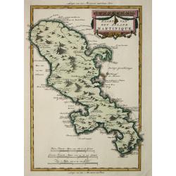
Het Westindisch Eiland Martenique
Taken from Isaac Tirion's atlas 'Nieuwe en Beknopte Hand-Atlas, bestaande in eene Verzameling van eenige der algemeenste en nodigste Landkaarten …' Decorative tropical ca...
Date: Amsterdam, 1750
Selling price: ????
Please login to see price!
Sold in 2016
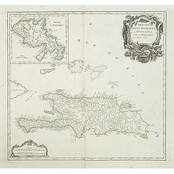
Isles de Saint Domingue ou Hispaniola, et de la Martinique.
A large map of Santo Domingo, with an inset showing the island of Martinique from his "Atlas Universel".Gilles Robert de Vaugondy (1688–1766), also known as Le ...
Date: Paris, 1750
Selling price: ????
Please login to see price!
Sold in 2011
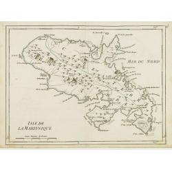
Isle de la Martinique.
Detailed map on the island of Martinique in the Caribbean. Villages, forts, mountains and bays all around the island are named. George Louis Le Rouge was active from 1740...
Date: Paris 1756
Selling price: ????
Please login to see price!
Sold
Carte Réduite de l'Isle de la Martinique Dresée au Dépost des Cartes et Journaux de la Marine Pour le Service des Vaisseaux du Roy. Par ordre de M. de Moras Ministre et Secretaire d'Etat ayant le Département de la Marine.
This handsome large scale chart shows parishes, towns, plantations, windmills, roads anchorages and a few soundings. The inset shows a close up of the town and harbor of ...
Date: Paris 1758
Selling price: ????
Please login to see price!
Sold
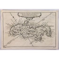
Carte de l'Isle de la Martinique.
A well engraved map of Martinique. The geographical features are typical, with somewhat exaggerated bays and inlets. From the l'Histoire Générale des Voyages. It features...
Date: Paris, 1758
Selling price: ????
Please login to see price!
Sold in 2018
Carte de l\' Isle de la Martinique.
Homann Heirs (of Johann Baptist and Johann Christof) published: Grosser Atlas, 1731, 1737. Geogr. Maior, 1759, Atlas Homannianus, 1762.A map of the island of Martinique.
Date: Nürnberg, 1762
Selling price: ????
Please login to see price!
Sold in 2011
Isle de la Martinique.
This chart shows the island of Martinique,.The only issue of this version of Bellin's map, slightly larger than the common version.From Bellin's Petit atlas maritime.Tome...
Date: Paris 1764
Selling price: ????
Please login to see price!
Sold
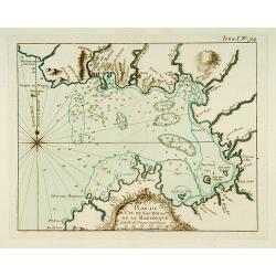
Partie du Cul de Sac Royal de la Martinique.
This chart shows the territories of the bay around Fort Royal on the island of Martinique.The only issue of this version of Bellin's map, slightly larger than the common ...
Date: Paris 1764
Selling price: ????
Please login to see price!
Sold
![Partie Septentrionale de la Martinique. / Partie Meridionale de la Martinique. [set of 2 maps]](/uploads/cache/17054-250x250.jpg)
Partie Septentrionale de la Martinique. / Partie Meridionale de la Martinique. [set of 2 maps]
A set of two maps depicting the island Martinique.Engraved by Croisey. The only issue of this version of Bellin's map, slightly larger than the common version. Depths sho...
Date: Paris 1764
Selling price: ????
Please login to see price!
Sold
Het Westindische Eiland Marteneque.
Izaak Tirion (d. 1769) Amsterdam publisher. His ' Nieuwe en beknopte handatlas' saw 6 editions between before 1740 and after 1784. Also ' Tegenwoordige staat van alle vol...
Date: Amsterdam, 1765
Selling price: ????
Please login to see price!
Sold in 2010
Het Westindisch Eiland Martenique.
Nice, decorative map of Martinique filled with good detail of roads, topography, soundings, villages, windmills, and plantations. The title cartouche incorporates the dis...
Date: Amsterdam, 1765
Selling price: ????
Please login to see price!
Sold
Carte de l\'Isle de la Martinique.
Rigobert Bonne (1727-1795), French cartographer. His maps are found in a.o. Atlas Moderne (1762), Raynal's Histoire Philos. du Commerce des Indes (1774) and Atlas Encyclo...
Date: Paris, 1774
Selling price: ????
Please login to see price!
Sold in 2010
Carte de L\'Isle de la Martinique.
Fine copper engraved map of the Island of Martinique in the Caribbean. It is detailed with lakes, rivers, cities, towns, mountains and forests. Nice block-style cartouche...
Date: Paris, 1779
Selling price: ????
Please login to see price!
Sold in 2014
Kaart van het eiland Martinique.
Willem Albert Bachiene (1712-1783), Dutch geographer in Maastricht. Most important work ' Heilige Geographie', a work on the Holy Land. Mathijs Schalenkamp published in 1...
Date: Amsterdam, 1785
Selling price: ????
Please login to see price!
Sold
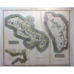
West India Islands - Martinico & Dominica.
A fine example of John Thomson's 1814 map of the West Indian islands of Dominica and Martinique. The map offers detail including individual buildings, villages, hospitals...
Date: Edinbourgh, 1814
Selling price: ????
Please login to see price!
Sold in 2021
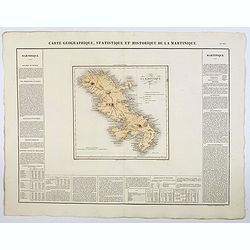
Carte Geographique, Statistique et Historique de la Martinique.
A nice detailed map of the island of Martinique, from Buchon's Atlas Gégraphique Statistique, historique et chronologique des deux Ameriques et des isles adjacentes tradu...
Date: Paris, 1825
Selling price: ????
Please login to see price!
Sold in 2019
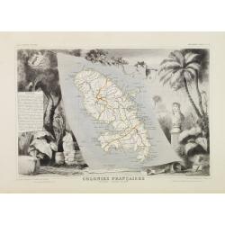
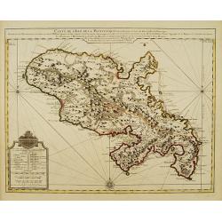
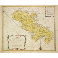
Colonies Françaises. Martinique - Amérique du Sud.
A very decorative 19th century map of the Martinique Island. The map is surrounded by the products of the island like tobacco, sugar, etc. A decoration of trees and birds...
Date: Paris 1850
Selling price: ????
Please login to see price!
Sold
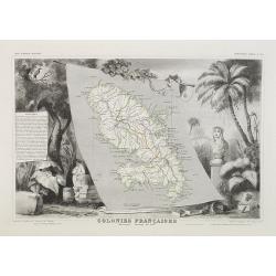
Colonies Françaises Martinique. Amérique du Sud. N°90.
Map of Martinique.A very decorative 19th century map of Martinique Island. The map is surrounded by the products of the island like tobacco, sugar, etc. A decoration of t...
Date: Paris, A. Combette, 1852
Selling price: ????
Please login to see price!
Sold in 2018
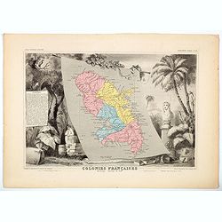
Colonies Françaises. Martinique. Amérique du Sud.
Beautiful map from one of the finest decorative atlases of the nineteenth century. The map is surrounded with engravings depicting the countryside with trade goods includ...
Date: Paris 1856
Selling price: ????
Please login to see price!
Sold in 2016
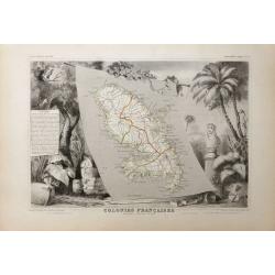
Colonies Francaises - Martinique Amerique du Sud.
A beautiful map from one of the finest decorative atlases of the nineteenth century. The map is surrounded with engravings depicting the countryside with trade goods incl...
Date: Paris, 1856
Selling price: ????
Please login to see price!
Sold in 2020
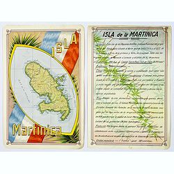
Isla Martinica.
A beautiful hand colored, hand drawn map of the French Caribbean island of Martinique, prepared for the Buenos Aires 1939 Philatelic Exhibition, with separate text with d...
Date: Buenos Aires, 1939
Selling price: ????
Please login to see price!
Sold in 2019
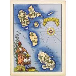
La Guadeloupe La Martinique.
Very decorative, informative map the French islands of Guadeloupe and Martinique among others. The map is filled with buildings, animals, a ship, figures and three locals...
Date: France, 1943
Selling price: ????
Please login to see price!
Sold in 2010
