Browse Listings in America > Caribbean & Atlantic Ocean > Jamaica
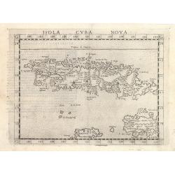
Isola Cuba Nova
This important Ruscelli map of Cuba from his work La Geografia di Claudio Tolomeo Alessandrino, is based on Gastaldi’s earlier map of the same region, dated 1548. Althoug...
Date: Venice, 1570
Selling price: ????
Please login to see price!
Sold in 2023
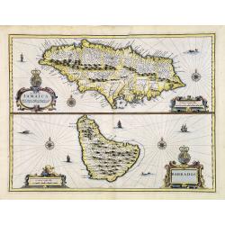
A Map of Jamaica & Barbados.
A Map of Jamaica and Barbados on one sheet, both with elaborate strapwork cartouches and mileage scales, compass roses and numerous rhumb lines. This is one of the new ma...
Date: London, 1676
Selling price: ????
Please login to see price!
Sold in 2013
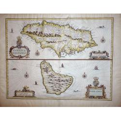
A Map of Jamaica & Barbados.
A Map of Jamaica and Barbados on one sheet,both with elaborate strapwork cartouches and mileage scales, compass roses and numerous rhumb lines. This is one of the new map...
Date: London, 1676
Selling price: ????
Please login to see price!
Sold in 2012
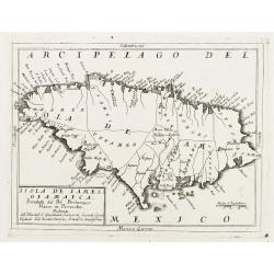
Isola de Iames, o Giamaica. . .
A decorative map of Jamaica with many details, bays, islands, and shows all the islands different parishes.
Date: Venice, ca. 1690
Selling price: ????
Please login to see price!
Sold in 2017
Isola de Iames, o Giamaica..
Map of Jamaica by the remarkable Vincenzo Coronelli, (1650-1718), a Franciscan Friar and appointed General of the Order in 1701.He was cosmographer to the Republic of Ven...
Date: Venice 1690
Selling price: ????
Please login to see price!
Sold
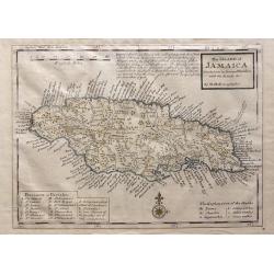
A New Map of the Island of Jamaica.
Finely engraved map of Jamaica showing towns, churches, sugar works, cotton works, indico works and cacao works. Rich nomenclature illustrating the coast.Adorned with a c...
Date: London 1717
Selling price: ????
Please login to see price!
Sold
The Island of Jamaica Divided into its Principal Parishes with the Roads & c.
The Island of Jamaica Divided into its Principal Parishes with the Roads & c. by Herman Moll. A highly detailed map of the island engraved with mountains, roads, town...
Date: London, 1736
Selling price: ????
Please login to see price!
Sold in 2016
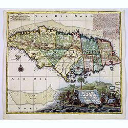
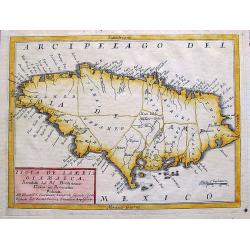
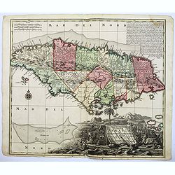
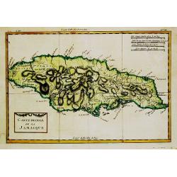
Nova Designatis Insulae Jamaicae ex Antillanis Americae Septentrion. . .
The Caribbean island of Jamaica is shown divided into its various precincts, and there is a large, beautiful title cartouche that shows natives harvesting the various pro...
Date: Augsburg, 1740
Selling price: ????
Please login to see price!
Sold in 2017
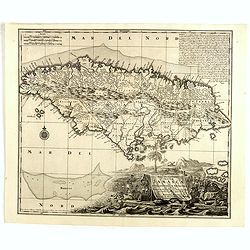
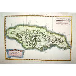
Nova Designatis Insulae Jamaicae.
An attractive map with a large, uncolored, very decorative cartouche, where the production of sugar is beautifully illustrated. The island is divided up into 13 distinct ...
Date: Augsburg, 1740
Selling price: ????
Please login to see price!
Sold in 2019
Nova Designatis Insulae Jamaicae.
In a large, uncolored, very decorative cartouche the production of sugar is illustrated.
Date: Augsburg, 1740
Selling price: ????
Please login to see price!
Sold in 2014
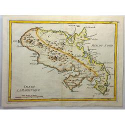
Isle de la Martinique.
An antique copperplate map featuring the French island of Martinique. In 1692, Charles de La Roche-Courbon, Count of Blénac, the Governor and Lieutenant General of the Fr...
Date: Paris, 1746
Selling price: ????
Please login to see price!
Sold in 2021
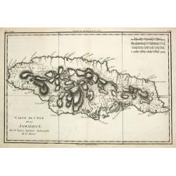
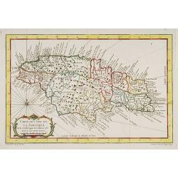
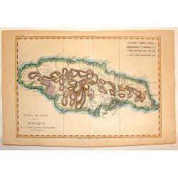
Carte de l?Isle de La Jamaique.
Jaques Nicolas Bellin (1702-720) was the most important French hydrographer of the 18th century. Sea-atlas 'Hydrographique Français' , 1756-65, atlas to accompany Prévost...
Date: Paris, 1758
Selling price: ????
Please login to see price!
Sold
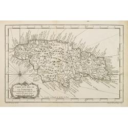
Carte de L'Isle de La Jamaique..
A good engraved map of the island with rococo title cartouche lower left.
Date: Paris, 1758
Selling price: ????
Please login to see price!
Sold in 2017
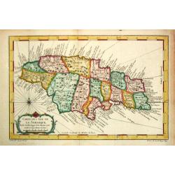
Carte de L'Isle de La Jamaique..
A good engraved map of the island Jamaica with rococo title cartouche lower left. From l'Histoire générale des voyages .
Date: Paris 1758
Selling price: ????
Please login to see price!
Sold
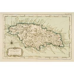
Carte de l?Isle de La Jamaique.
Jaques Nicolas Bellin (1702-720) was the most important French hydrographer of the 18th century. Sea-atlas 'Hydrographique Français' , 1756-65, atlas to accompany Prévost...
Date: Paris, 1758
Selling price: ????
Please login to see price!
Sold
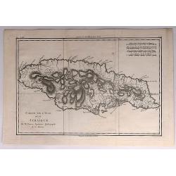
Carte de l'Isle de la Jamaïque.
This chart shows the island of Jamaica.The only issue of this version of Bellin's map, slightly larger than the common version.From Bellin's Petit atlas maritime.Tome I N...
Date: Paris 1764
Selling price: ????
Please login to see price!
Sold
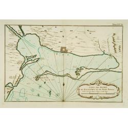
Carte des Havres de Kingstown et de Port Royal.
This chart shows the harbour of Kingston and the fortress of Port Royal.The only issue of this version of Bellin's map, slightly larger than the common version. Depths sh...
Date: Paris 1764
Selling price: ????
Please login to see price!
Sold
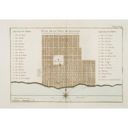
Plan de la Ville de Kingston Suivant le projet donné par le Colonel Christian Lilly.
Plan of the city of Kingston on Jamaica. With a numbered key (1-32) referring to the names of the principal streets.The only issue of this version of Bellin's map, slight...
Date: Paris 1764
Selling price: ????
Please login to see price!
Sold
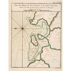
Plan des Havres de Port Antonio et de Saint François Situés a la Coste du Nord Est de la Jamaïque.
This chart shows the territories and harbour of Port Antonio on the island of Jamaica. The only issue of this version of Bellin's map, slightly larger than the common ver...
Date: Paris 1764
Selling price: ????
Please login to see price!
Sold
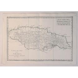
Carte de l''Isle de la Jamaique.
Rigobert Bonne (1727-1795), French cartographer. His maps are found in a.o. Atlas Moderne (1762), Raynal's Histoire Philos. du Commerce des Indes (1774) and Atlas Encyclo...
Date: Paris, 1774
Selling price: ????
Please login to see price!
Sold
Carte de L'Isle de la Jamaique.
Hand-colored, copper plate map of the island of Jamaica in the Caribbean. Detailed presentation of the settlements, ports and forts. BONNE, RIGOBERT (1729-1795). Bonne w...
Date: Paris, 1780
Selling price: ????
Please login to see price!
Sold in 2013
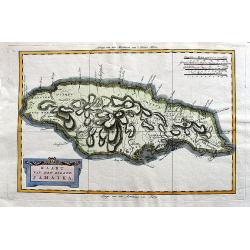
Kaart van het eiland Jamaika.
An uncommon and very attractive Dutch map of Jamaica. The island's mountains are boldly engraved and there is excellent detail of the various river systems provided. The ...
Date: Amsterdam, ca 1780
Selling price: ????
Please login to see price!
Sold in 2020
Carte de L'Isle de la Jamaique.
A fine example of Rigobert Bonne and Guilleme Raynal's 1780 map of Jamaica. Highly detailed, showing towns, rivers, some topographical features, political boundaries and ...
Date: Paris, 1780
Selling price: ????
Please login to see price!
Sold in 2020
Carte de L'Isle de la Jamaique.
A fine map of the Island of Jamaica. A good example of Rigobert Bonne and Guilleme Raynal's 1780 map of Jamaica. Detailed, with towns, rivers, some topographical features...
Date: Paris, 1780
Selling price: ????
Please login to see price!
Sold in 2018
Kaart van het Eiland Jamaika.
An uncommon and very attractive map of Jamaica. The island's mountains are boldly engraved and excellent detail of the various river systems is provided. The parishes are...
Date: Amsterdam, c. 1780
Selling price: ????
Please login to see price!
Sold
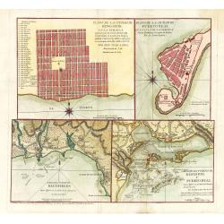
Plano de la Ciudad de Puerto Real, En La Isla De La Jamaica Segun Bontein y la copia de Bellin: Por D. Juan Lopez
This scarce work features a set of four Spanish maps on one sheet depicting Spanish towns and harbor plans of important Jamaican ports.Spanish settlement of Jamaica began...
Date: Madrid, 1782
Selling price: ????
Please login to see price!
Sold in 2023
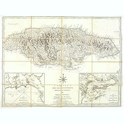
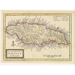
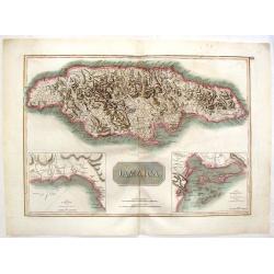
Jamaica from the latest surveys, improved and engraved by Thomas Jefferys. . .
Detailed map of Jamaica, showing parishes, towns and villages, churches, forts, roads, rivers and ponds, harbors, anchorages, soundings, etc.Includes an annotation at upp...
Date: London, 1794
Selling price: ????
Please login to see price!
Sold in 2018
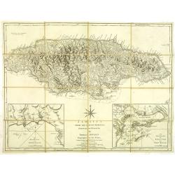
Jamaica from the latest surveys, improved and engraved by Thomas Jefferys. . .
Detailed map of Jamaica, showing parishes, towns and villages, churches, forts, roads, rivers and ponds, harbors, anchorages, soundings, etc.Includes an annotation at upp...
Date: London, 1794
Selling price: ????
Please login to see price!
Sold in 2012
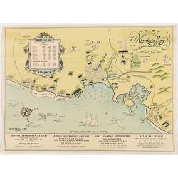
Montego Bay Jamaica, B.W.L.
Beautiful vintage pictorial tourist map of the Montego Bay in Jamaica, with key to distances to hotels and guest houses. In lower part publicity for railway and motor car...
Date: London, 1800
Selling price: ????
Please login to see price!
Sold in 2020
Charte von Jamaica In Kirchspiele eingetheilt und mit den Poststrassen.
General map of Jamaica, shows the postal roads, churches, towns, harbours, rivers, mountains and many other details. One of the earliest obtainable maps of Jamaica to loc...
Date: Weimar, 1805
Selling price: ????
Please login to see price!
Sold in 2020
Isle de la Jamaïque.
Map of Jamaica, from Atlas de la Géographie de toutes les parties du monde.. Ouvrage destiné pour l'education, et nécessaire aux négocians, aux voyageurs, aux fonctionnai...
Date: Paris, Prudhomme, Levrault, Debray, 1806
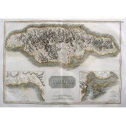
Jamaica.
Large map of the island with insets of 'The Harbour of Bluefields' and 'The Harbours of Kingston and Port Royal'. This map was based on Jefferys' map of 1775. The map is ...
Date: London, 1814
Selling price: ????
Please login to see price!
Sold in 2017
Jamaica.
Fine hand-colored map featuring the island of Jamaica. Inserts of the Harbour of Bluefields and The Harbours of Kingston & Port Royal. From Thomson's "New Genera...
Date: Edinburgh, 1817
Selling price: ????
Please login to see price!
Sold in 2016
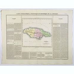
Carte Geographique, Statistique et Historique de la Jamaique.
A nice detailed map of the island of Jamaica, from Buchon's Atlas Gégraphique Statistique, historique et chronologique des deux Ameriques et des isles adjacentes traduit ...
Date: Paris, 1825
Selling price: ????
Please login to see price!
Sold in 2023
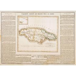
Jamaica.
This is the map of Jamaica is from a plano edition of the very scarce German edition of Carey & Lea's "A Complete Historical, Chronological, and Geographical Ame...
Date: Weimar, 1822-1825
Selling price: ????
Please login to see price!
Sold
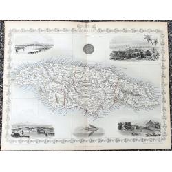
Jamaica
Fantastic map of Jamaica from the famous Atlas by John Tallis & company published in London & New York around 1850.It shows the island in great detail, filled wit...
Date: London & New York, c1851
Selling price: ????
Please login to see price!
Sold in 2021
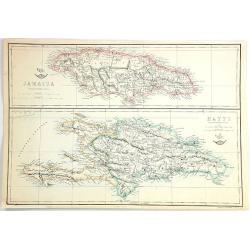
Jamaica & Hayti
Two maps on one sheet, the top showing Jamaica, and the bottom, the island of Haiti and Hispaniola. Published at the "Weekly Dispatch" Office in London in 1863...
Date: London, 1863
Selling price: ????
Please login to see price!
Sold in 2016
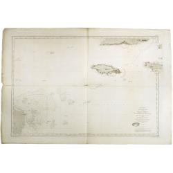
Mer des Antilles. Carte des passages entre Cuba, La Jamaique et la cote des mosquitos. . .
Detailed centered on Jamaica and the Cayman Islands. Engraved by Chassant and the text by Carré. Lighthouse have a yellow/red dot and additional red printed explanation....
Date: Paris, 1867
Selling price: ????
Please login to see price!
Sold in 2018
