Browse Listings in America > Caribbean & Atlantic Ocean
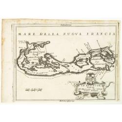
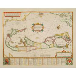
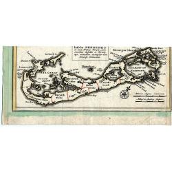
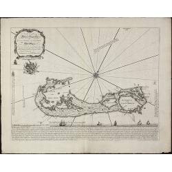
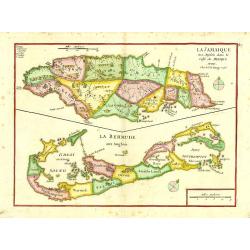
Le Bermude, Dedicate All'Illusstrissimo Sig:r Abbate Isidoro Bernardi.
Fine map of Bermuda with the title cartouche incorporating a the cardinal’s arms beneath, this map occurred in an atlas called ‘Corso Geographico Universale’.The remarkab...
Date: Venice, 1696
Selling price: ????
Please login to see price!
Sold in 2014
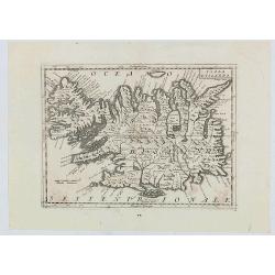
Isola d'Islanda
The map is a reduced copy of Joris Carolus', but the forms of the names and other features suggest that the model was the version by Johannes Janssonius rather than that ...
Date: Venice, 1697
Selling price: ????
Please login to see price!
Sold in 2020
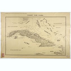
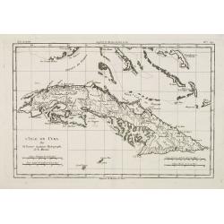
Kaart van Cuba. Bijvoegsel behoorende bij het 2e blad van de nieuwe Rotterdamsche Courant van Vrijdag 6 Mei 1898.
Lithographed map of Cuba, including southern tip of Florida with the Keys and the Bahama Islands. Several folds as issued, some underlaid with archival tape. Published as...
Date: Rotterdam, 1698
Selling price: ????
Please login to see price!
Sold in 2017
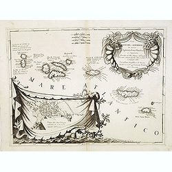
Isole Azzori, o Azzoridi. . .
A beautiful and highly decorative map of the Azores Islands. With large title cartouche in the upper right corner decorated with coral, fish, seaweeds and pearl chains.In...
Date: Venice, 1698
Selling price: ????
Please login to see price!
Sold in 2013
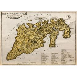
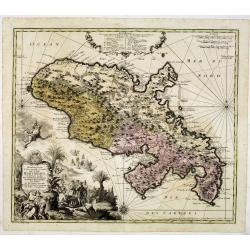
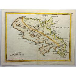
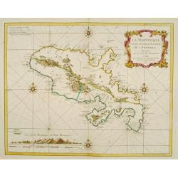
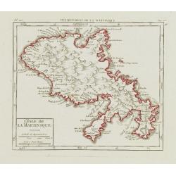
L'Isle de la Martinique.
Map of the island of Martinique, engraved by F.Starckman, from De Fer's Atlas Curieux.
Date: Paris, 1704
Selling price: ????
Please login to see price!
Sold in 2009
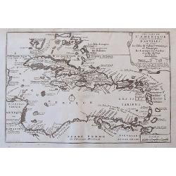
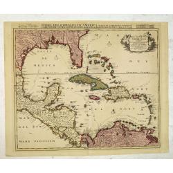
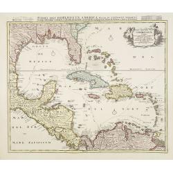
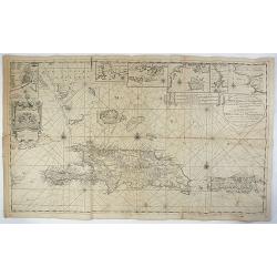
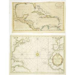
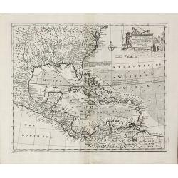
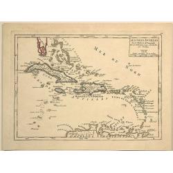
Les Isles De L'Amerique Connues Sous le Nom D'Antilles, ou Sont les Isles de Cuba, St. Domingue et Jamaique, les Lucayes, les Caribes, et celles du Vent.
A detailed copper engraved map of the West Indies, from Florida and the Bahamas until Venezuela and Trinidad. With many place names, islands, bays, and several notes on t...
Date: Paris, 1705
Selling price: ????
Please login to see price!
Sold in 2017
![[Lot of 10 (2x maps / 8x views of Guyana)] d' Engleze Volksplanting in' t Amerikaans Gewest Gujana en Rio de Las Amazones. Door de Scheeps-Togt van Charles Leig Begonnen.](/uploads/cache/IMG_2322-250x250.jpg)
[Lot of 10 (2x maps / 8x views of Guyana)] d' Engleze Volksplanting in' t Amerikaans Gewest Gujana en Rio de Las Amazones. Door de Scheeps-Togt van Charles Leig Begonnen.
[Lot of 10 (2x maps / 8x views of Guyana]- d'Engelze Volkplanting in't Amerikaans gewest Gujana en Rio de las Amazones. circa 1700 - Land-Kaart van het Eiland en de Volk...
Date: Leiden, 1706-1707
Selling price: ????
Please login to see price!
Sold in 2023
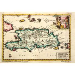
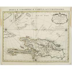
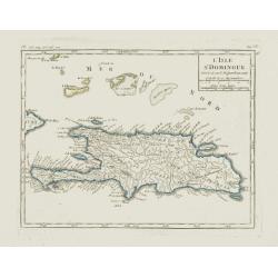
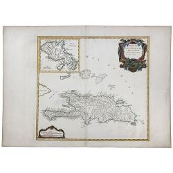
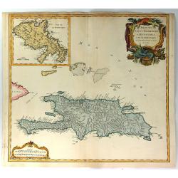
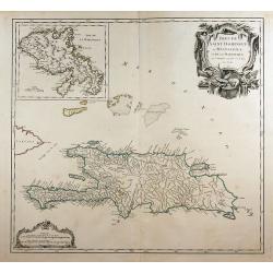
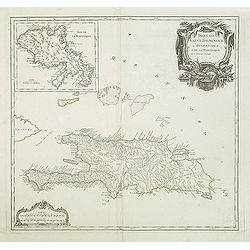
Hispaniola.
A map of the island of Hispaniola with an attractive cartouche. Pieter van der Aa was a prolific publisher. He published a.o. "Naauwkeurge versameling der gedenkwaar...
Date: Leiden, 1707
Selling price: ????
Please login to see price!
Sold in 2020
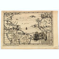
H. Benzos Scheep-togt uit Italie over Spanje na de Westindize Eylanden, en Kusten van't Zuider America.
A delightful map of the Atlantic Ocean highlighting the route of explorer Hieronymus Benzon, who travelled from Spain to the Americas, and back to Italy between 1541-56. ...
Date: Leiden, ca 1710
Selling price: ????
Please login to see price!
Sold in 2020
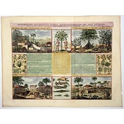
Descriptions des Plantes, Arbres, Animaux & Poissons des Iles Antilles.
An interesting sheet with eight detailed views illustrating fauna and flora on the Antillean islands, and how the slaves make sugar, with descriptive French text, from Ch...
Date: Amsterdam, 1715
Selling price: ????
Please login to see price!
Sold in 2020
Terra Neuf, en de Custen van Nieu Vranckryck, Nieu Engeland, Nieu Nederland, Nieu Andalusia, Guiana en Venezuela
L. Renard's edition of Frederick de Wit's magnificent Atlantic chart oriented to the East. From the 1715 edition of "Atlas de la Navigation et du Commerce". A f...
Date: Amsterdam, 1715
Selling price: ????
Please login to see price!
Sold in 2012
Pas kaart Van Rio Oronoque Golfo de Paria met d'Eylanden Trinidad, Tabago, Granada, Granadillos, en Bequia ...
Double page chart of the mouth of the Orinoco and the adjacent Venezuelan coastline orientated with north to the right edge. The islands of Trinidad, Tobago and Grenada s...
Date: Amsterdam, Gerard van Keulen 1717
Selling price: ????
Please login to see price!
Sold in 2020
Pas Kaart Van de Noord Kust van Espaniola met d'Eylanden door Benoorden
Double page chart showing the north coast of Hispaniola with the adjacent islands of the Turks and Caicos. Inset charts of the island of Tortue and the bay of Gonaives. T...
Date: Amsterdam: [Gerard van Keulen 1717
Selling price: ????
Please login to see price!
Sold in 2020
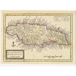
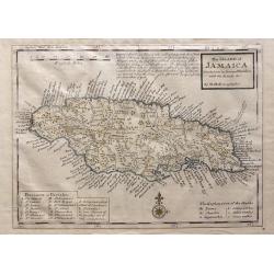
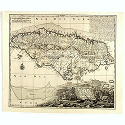
A New Map of the Island of Jamaica.
Finely engraved map of Jamaica showing towns, churches, sugar works, cotton works, indico works and cacao works. Rich nomenclature illustrating the coast.Adorned with a c...
Date: London 1717
Selling price: ????
Please login to see price!
Sold
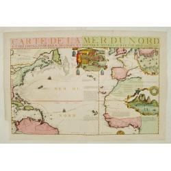
Carte de la Mer du Nord.
Fine map of the Atlantic Ocean. An extremely rare edition of the De Fer map. With 3 inset maps. Lower right Cape of Good Hope, upper right Gibraltar, and in upper center ...
Date: Paris 1719
Selling price: ????
Please login to see price!
Sold
Insulae Americanae Nempe: Cuba, Hispaniola, Iamaica, Pto Rico, Lucania, Antillae vulgo Caribe, Barlo-et Sotto-Vento Etc. . . .
A rare re-issue of the plate by Danckerts. The West Indies with the gulf of Mexico and Florida. The map shows prominently in the center Cuba, Haiti, the Bahamas and Flori...
Date: Amsterdam, 1720
Selling price: ????
Please login to see price!
Sold in 2013
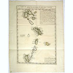
Carte des Antilles Françoises et des Isles voisines dressée sur des Mémoires Manuscrits.
Map of the West Indies Islands, with descriptive French text, from Chatelain's monumental 7 volume "Atlas Historique".Henri Abraham Chatelain (1684 – 1743) was ...
Date: Amsterdam, 1720
Selling price: ????
Please login to see price!
Sold in 2017
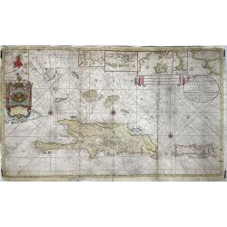
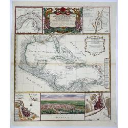
Indiarum Occidentalium Tractus Littoralis cum Insulis..
One of the most splendidly engraved Dutch charts of the Caribbean with two decorative cartouches, one of which illustrates Native American cannibals preparing a meal. Inc...
Date: Amsterdam 1720
Selling price: ????
Please login to see price!
Sold
Mappa Aestivarum Insularum, alias Barmudas..
The map is the rare re-issue of the Blaeu's copperplate of 1630. The map includes the arms of Bermuda and England, and lists proprietors of the various tribes into which ...
Date: Amsterdam 1720
Selling price: ????
Please login to see price!
Sold
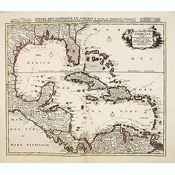
Stoel des Oorlogs in America Waar in Vertoont Werden Alle Desself Voornaamste Eylande . . .
Large impressive map of the West Indies with the Gulf of Mexico and Florida. The map shows prominently in the center Cuba, Haiti, the Bahamas and Florida, which is here m...
Date: Amsterdam, c. 1720
Selling price: ????
Please login to see price!
Sold in 2014
Nieuwe Wassende graadige Pas-kaart van de kust van Guinea en Brasilia..
Engraved by I.van Anse. A very representative example of a Dutch chart of the Atlantic.The chart shows the western coast of Africa but the information provided in the map...
Date: Amsterdam c.1720
Selling price: ????
Please login to see price!
Sold
Carte de l'Isle de Saint Domingue Dressée en 1722 pour l'usa
Map of the island Hispaniola, now Haiti and the Dominican Republic. Embellished with a charming title cartouche and two compass roses. Shows the south easternmost part of...
Date: Amsterdam, 1720
Selling price: ????
Please login to see price!
Sold in 2008
Insulae Americanae Nempe: Cuba, Hispaniola, Iamaica, Pto Rico, Lucania, Antillae vulgo Caribe, Barlo-et Sotto-Vento Etc. . . .
A rare re-issue of the plate by Danckerts. The West Indies with the gulf of Mexico and Florida. The map shows prominently in the centre Cuba, Haiti, the Bahamas and Flori...
Date: Amsterdam, 1720
Selling price: ????
Please login to see price!
Sold in 2009
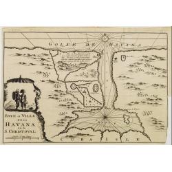
Baye et Ville de La HAVANA ou de S. CHRISTOVAL.
Attractive map centred on the town Havana and its large bay.
Date: Amsterdam 1722
Selling price: ????
Please login to see price!
Sold
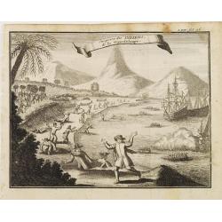
Surprise des INDIENS de la Guardeloupe..
Interesting print depicting the arrival of Europeans in Guadeloupe.From the book Nouvelle Relation, Contenant LES VOYAGES DE THOMAS GAGE dans la nouvelle Espagne [..] jus...
Date: Amsterdam 1722
Selling price: ????
Please login to see price!
Sold
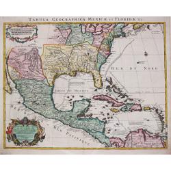
Tabula Geographica Mexicae et Floride des Terres Angloises et des Isles Antilles, du Cours et des Environs de la Riviere de Mississipi. Par G. de l' Isle a Amsterdam chéz Jean Covens & Corneille Mortier. 1722.
Guillaume de l' Isle (1675-1724), Royal Geographer, was the most influential cartographer of the first quarter of the 18th century. ' Atlas de Géographie' (1700-12), post...
Date: Amsterdam, 1722
Selling price: ????
Please login to see price!
Sold in 2022
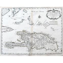
Carte de l'Isle de Saint Domingue Dressee en 1722. . .
An excellent map of Hispaniola with many details: Towns are connected with roads, many small rocks and islands shown, including Tortuga. Extends to show a tip of Cuba, an...
Date: Paris, 1725
Selling price: ????
Please login to see price!
Sold in 2020
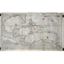
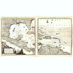
Nouvelle Carte Marine de Toute les Cotes de l´Amerique ... / Nieuwe grote en zeer curieuze Paskaart van Geheel WestIndien ...
Large size sea chart of the Caribbean and surrounding coasts, by Gerard van Keulen, son of Johannes Van Keulen. A rare map since these larger-sized sheets were never publ...
Date: 1728
Selling price: ????
Please login to see price!
Sold in 2022
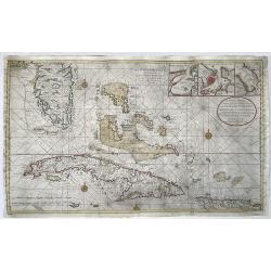
Nieuwe en Naeukeurige Afteekening vant Canaal van Bahama... / Nouvelle Carte Marine du Canal de Bahama...
Large size nautical sea chart of the Florida peninsula, Bahamas, Cuba and Hispaniola. Printed on two sheets, joined.Southern Florida and the Keys are depicted with great ...
Date: Amsterdam, 1728
Selling price: ????
Please login to see price!
Sold in 2022
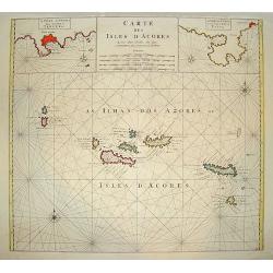
Carte des Isles d? Acores.
An uncommon and highly attractive map of the Azores. It contains much detail, with inset maps of Porto de Santa Cruz along with the town of Angra, located on the island o...
Date: Amsterdam, 1730
Selling price: ????
Please login to see price!
Sold
Carte des Isles d'Acores.
Uncommon and detailed map of the Azores.
Date: Amsterdam, 1730
Selling price: ????
Please login to see price!
Sold in 2015

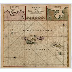
Carte des Isles d'Acores.
Uncommon and detailed map of the Azores. With inset maps of Port de St.Cruz and harbor and town of Angra on the island of Terceira. It was at the time an important port a...
Date: Amsterdam, 1730
Selling price: ????
Please login to see price!
Sold in 2024
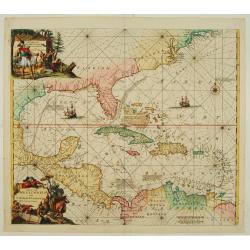
Insulae Bermudes in suas Tribus divisae...
Copper-engraved map of Bermuda most probably from a larger Homann composite sheet showing also other islands. Shows the island in good detail, naming towns and villages, ...
Date: Nuremberg, c1730
Selling price: ????
Please login to see price!
Sold in 2011
The Island of Jamaica Divided into its Principal Parishes with the Roads & c.
The Island of Jamaica Divided into its Principal Parishes with the Roads & c. by Herman Moll. A highly detailed map of the island engraved with mountains, roads, town...
Date: London, 1736
Selling price: ????
Please login to see price!
Sold in 2016
To his Excellency Alured Popple Esq. Governour of Bermuda, or the Summer Islands. This Map.
Important and exceptional rare sea chart of the Bermuda IslandsClement Lempriere's chart of Bermuda, published in 1738, was the next major advance after Arent Roggeveen c...
Date: London, 1738
Selling price: ????
Please login to see price!
Sold in 2010
Nova Designatis Insulae Jamaicae.
An attractive map with a large, uncolored, very decorative cartouche, where the production of sugar is beautifully illustrated. The island is divided up into 13 distinct ...
Date: Augsburg, 1740
Selling price: ????
Please login to see price!
Sold in 2019
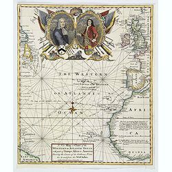
A New Map or Chart of The Western or Atlantic Ocean with Part of Europe, Africa & America: Shewing the Course of the Galleons. . .
An attractive chart of the Atlantic Ocean with large decorative cartouche, from 'The Gentleman's Magazine: and Historical Chronicle', by Sylvanus Urban, printed by Edward...
Date: London, 1740
Selling price: ????
Please login to see price!
Sold in 2019
Nova Designatis Insulae Jamaicae ex Antillanis Americae Septentrion. . .
The Caribbean island of Jamaica is shown divided into its various precincts, and there is a large, beautiful title cartouche that shows natives harvesting the various pro...
Date: Augsburg, 1740
Selling price: ????
Please login to see price!
Sold in 2017
Nova Designatis Insulae Jamaicae.
In a large, uncolored, very decorative cartouche the production of sugar is illustrated.
Date: Augsburg, 1740
Selling price: ????
Please login to see price!
Sold in 2014
Representation la plus nouvelle et exacte De L'Ile Martinique, la premiere des Iles Del' Amerique Antilles Nommees Barlovento, Aux depens...
Fine map of Martinique with an extremely decorative cartouche that depicts the native islanders meeting and trading with Europeans. Engraved by Albrecht Carl Seutter (172...
Date: Augsburg, c. 1740
Selling price: ????
Please login to see price!
Sold
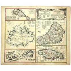
![[Five maps on one sheet] Dominia Anglorum in praecipuis Insulis Americae ut sunt Insula S. Christopheri, Antegoa, Iamaica, Barbados nec non Insula Bermudes vel Sommers . . .](/uploads/cache/25265-250x250.jpg)
[Five maps on one sheet] Dominia Anglorum in praecipuis Insulis Americae ut sunt Insula S. Christopheri, Antegoa, Iamaica, Barbados nec non Insula Bermudes vel Sommers . . .
Interesting set of 5 maps on a single sheet, showing Jamaica, Bermuda, Antigua, Barbados and St. Kitts. With a large decorative title cartouche. Each map is very detailed...
Date: Nuremberg, 1740
Selling price: ????
Please login to see price!
Sold in 2008
Nouvelle Carte Particuliere de l'Amerique ou sont Exactement Marquees les Iles de Bermude, la Iamaique, Saint Domingue, les Antilles la Terre Ferme. . .
The two lower maps, with their own border title, of the four-sheet Dutch edition of Popple's monumental map of North America.It covers the region from Bermuda through the...
Date: Amsterdam, 1741
Selling price: ????
Please login to see price!
Sold
Nieuwe en Naaukeurige Paskaart van Het Eyland Hispaniola of St. Domingo met alle desselfs Havenen, Dieptens en Ankergronden, als meede de door passeeringe tusche de Caiques en andere Eylanden. ..
Fine Sea Chart of Puerto Rico and Hispaniola, published by Johannes Van Keulen II. A rare map since these larger sized sheets were never published in atlases but were ra...
Date: 1742
Selling price: ????
Please login to see price!
Sold in 2022
Nieuwe en Naaukeurige Paskaart van Het Eyland Hispaniola of St. Domingo met alle dresslss Havenen, Dieptens en Ankergronden, als meede de door passeeringe tusche de Caiques en andere Eylanden. naer de Opservatien van Monsr. Frezier. . .​
This rare magnificent large chart of Hispaniola and Puerto Rico was published by Johannes van Keulen II. The chart was compiled from the chart made by Amedee Francois Fre...
Date: Amsterdam, ca. 1742
Selling price: ????
Please login to see price!
Sold in 2018
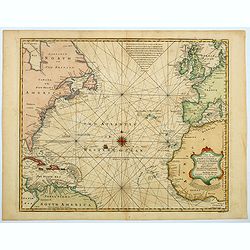
A New and Accurate Chart of the Western or Atlantic Ocean. . .
A map that is typical of the sort published by Emanuel Bowen. This chart of the Western or Atlantic Ocean contains numerous annotations, which lend a fascination and char...
Date: London, 1744
Selling price: ????
Please login to see price!
Sold in 2023
DOMINIA ANGLORUM in praecupuis Insulis AMERICAE ut sunt Insula S. CHRISTOPHORI, ANTEGOA, IAMAICA, BARBADOS, Insulae BERMUDES vel SOMMERS.
Set of 5 maps on a single sheet, outlined hand-colored, showing St. Kitts, Antigua, Bermuda, Barbados, and Jamaica, each in excellent detail with names and descriptions. ...
Date: Nuremberg, 1745
Selling price: ????
Please login to see price!
Sold in 2020
Carte de L' Isle de la Martinique Colonie Francoise de l'une des Isles Antilles de l'Amerique..
A very well executed plan of the island after Delisle. Excellent detail throughout includes realistic depictions of bays, mountains, islets, lagoons, forests, etc., which...
Date: Amsterdam c. 1745
Selling price: ????
Please login to see price!
Sold
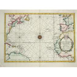
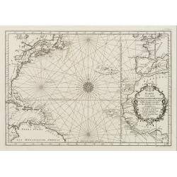
Carte de l' Ocean Occidental.
Jaques Nicolas Bellin (1702-720) was the most important French hydrographer of the 18th century. Sea-atlas 'Hydrographique Français' , 1756-65, atlas to accompany Prévost...
Date: Paris, 1746
Selling price: ????
Please login to see price!
Sold
Isle de la Martinique.
An antique copperplate map featuring the French island of Martinique. In 1692, Charles de La Roche-Courbon, Count of Blénac, the Governor and Lieutenant General of the Fr...
Date: Paris, 1746
Selling price: ????
Please login to see price!
Sold in 2021
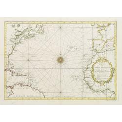
Carte De L'Ocean Occidental Dreessée pour Servir a l'Histoire Generale des voyages..
Attractive chart of the Atlantic, north of the equator, delineated with rhumb lines and a large 32-point compass rose.A good portion of each of the continents is shown wi...
Date: Paris 1746
Selling price: ????
Please login to see price!
Sold
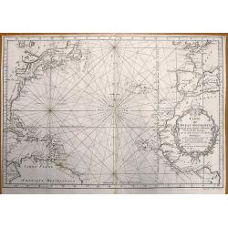
Carte de l'Ocean Occidental Dressee pour Servir a l'Histoire Generale des Voyages.
Bellin's superb North Atlantic sea chart. Shows the east coast of North America, the north coast of South America, the West Indies, Western Europe and West Africa. With t...
Date: Paris, 1746
Selling price: ????
Please login to see price!
Sold in 2013
Carte de l'Océan Occidental Dressée pour servir à l'Histoire Générale des Voyageurs. (together with) A new map of the West Indies.
Attractive chart of the Atlantic, north of the equator, delineated with rhumb lines and a large 32-point compass rose.A good portion of each of the continents is shown wi...
Date: Paris, 1746
Selling price: ????
Please login to see price!
Sold in 2014
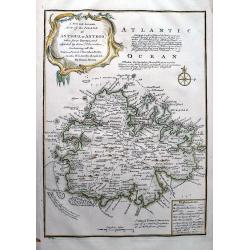
A New and Accurate Map of the Island of Antigua or Antego...
Highly attractive map of Antigua. Very detailed map with many place names, streets, etc. With text describing the island and a legend explaining symbols to churches, for...
Date: London, 1747
Selling price: ????
Please login to see price!
Sold in 2012
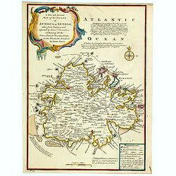
A New and Accurate Map of the Island of Antigua or Antego. . .
Bowen's maps of Antigua from A Complete System of Geography.. Decorated with a compass rose and a title cartouche. With extensive details and interesting annotations abou...
Date: London, 1747
Selling price: ????
Please login to see price!
Sold in 2023
An Accurate Map of the West Indies
Bowen's map of the West Indies from 'A Complete System of Geography'. Showing the area from Long Island in the north to the delta of the Orinoco in the south. Decorated w...
Date: London, 1747
Selling price: ????
Please login to see price!
Sold in 2011
La Jamaique..Golfe du Mexique/ La Bermude.
"Two maps on one sheet; Jamaica and Bermuda. George Louis Le Rouge was active from 1740- till 1780 as a publisher, and was appointed engineer for the King of France....
Date: Paris 1748
Selling price: ????
Please login to see price!
Sold
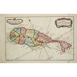
Les Isles Antilles.
Pleasing example of De Vaugondy's scarce map of the Caribbean. Note how Florida looked in the upper left corner. The map appeared in Vaugondy's "Atlas Portatif.&quo...
Date: Paris, 1748
Selling price: ????
Please login to see price!
Sold in 2023
La Martinique une des Antilles Françoises de L'Amerique..
Fine map of Martinique. George Louis Le Rouge was active from 1740- till 1780 as a publisher, and was appointed engineer for the King of France.
Date: Paris 1748
Selling price: ????
Please login to see price!
Sold
L'Isle St. Domingue.
Nice small map of Hispaniola. Including the Caicos Islands and the Great Inagua. From Atlas Portatif Universel, by Robert de Vaugondy.Page 535 and 95 outside border top r...
Date: Paris, later than 1748
Selling price: ????
Please login to see price!
Sold in 2012
L\'Isle de la Martinique.
Nice small map of Martinique. From Atlas Portatif Universel, by Robert de Vaugondy.Page 563 and 96 outside border top right. To the left Pl. 110.Mary Sponberg Pedley does...
Date: Paris, later than 1748
Selling price: ????
Please login to see price!
Sold in 2008
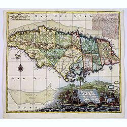
ISLES DE SAINT DOMINIGUE ou HISPANIOLA et de la Martinique.
This is a fine map of Hispaniola or Santo Domingo (modern day Haiti and the Dominican Republic) by Robert de Vaugondy. It includes the tip of Cuba and the Inagua Islands ...
Date: Paris, 1750
Selling price: ????
Please login to see price!
Sold in 2020
Mappa Geographica complectens. I. INDIAE OCCIDENTALIS partem mediam circum ISTHMUM PANAMENSEM. II. Ipsung Isthmuin. III. Ichnographiam praecipuorum locorum. . .
Six varying sized insets depict the West Indies: Panama, Saint Augustine, Vera Cruz, Santo Domingo, and a birds-eye view of Mexico City. The primary, largest inset map ha...
Date: Nuremberg, 1750
Selling price: ????
Please login to see price!
Sold in 2020
![Mappa Geographica Complectens I. Indiae Occidentalis Partem Mediam Circum Isthmum Panamensem. . . [With insets of St. Augstine, Florida, Mexico City, Panama, etc.]](/uploads/cache/42979-250x250.jpg)
Mappa Geographica Complectens I. Indiae Occidentalis Partem Mediam Circum Isthmum Panamensem. . . [With insets of St. Augstine, Florida, Mexico City, Panama, etc.]
Six varying sized insets depict the West Indies: Panama, Saint Augustine, Vera Cruz, Santo Domingo, and a birds-eye view of Mexico City. The primary, largest inset map ha...
Date: Nuremberg, 1750
Selling price: ????
Please login to see price!
Sold in 2019
Het Westindisch Eiland Martenique
Taken from Isaac Tirion's atlas 'Nieuwe en Beknopte Hand-Atlas, bestaande in eene Verzameling van eenige der algemeenste en nodigste Landkaarten …' Decorative tropical ca...
Date: Amsterdam, 1750
Selling price: ????
Please login to see price!
Sold in 2016
![[Lot of 22 maps / prints] Kaart van Mexico en Nieuw Granada in de Spaansche West-Indien.](/uploads/cache/20690-(3)-250x250.jpg)
[Lot of 22 maps / prints] Kaart van Mexico en Nieuw Granada in de Spaansche West-Indien.
A detailed map showing the Caribbeans, the Gulf of Mexico with its adjacent lands and Central America.. Izaak Tirion (d. 1769) Amsterdam publisher. His ' Nieuwe en beknop...
Date: Amsterdam, c. 1750
Selling price: ????
Please login to see price!
Sold in 2022
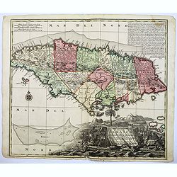
Isles de Saint Domingue ou Hispaniola, et de la Martinique.
This is a fine map of Hispaniola or Santo Domingo (modern day Haiti and the Dominican Republic) by Robert de Vaugondy. It includes the tip of Cuba and the Inagua Islands ...
Date: Paris, 1750
Selling price: ????
Please login to see price!
Sold in 2020
L'Isle de Cuba.
Detailed map of Cuba. Finely engraved with many soundings on banks. Numerous coastal place names. Several tracks noted. The Florida keys and the Bahamas are included.Jacq...
Date: Paris, 1750
Selling price: ????
Please login to see price!
Sold
![Mappa Geographica Complectens I. Indiae Occidentalis Partem Mediam Circum Isthmum Panamensem. . . [With insets of St. Augstine, Florida, Mexico City, Panama, etc.]](/uploads/cache/37359-250x250.jpg)
Mappa Geographica Complectens I. Indiae Occidentalis Partem Mediam Circum Isthmum Panamensem. . . [With insets of St. Augstine, Florida, Mexico City, Panama, etc.]
Six varying sized insets depict the West Indies: Panama, Saint Augustine, Vera Cruz, Santo Domingo, and a birds-eye view of Mexico City. The primary, largest inset map ha...
Date: Nuremberg, 1750
Selling price: ????
Please login to see price!
Sold in 2016
Isles de Saint Domingue ou Hispaniola, ...
A large map of Santo Domingo, with an inset showing the island of Martinique.
Date: Paris, 1750
Selling price: ????
Please login to see price!
Sold in 2011
Isles de Saint Domingue ou Hispaniola, et de la Martinique.
A large map of Santo Domingo, with an inset showing the island of Martinique from his "Atlas Universel".Gilles Robert de Vaugondy (1688–1766), also known as Le ...
Date: Paris, 1750
Selling price: ????
Please login to see price!
Sold in 2011
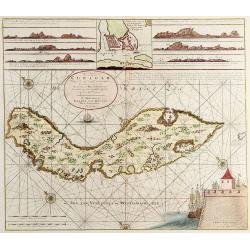
Nieuwe Afteekening van het Eijland Curaçao..
Decorative and extremely rare chart of Curaçao with several coastal insets and an inset of Fort Amsterdam and the Bay of St.Anna (127x135mm.)Besides the island of Curacao...
Date: Amsterdam, 1751
Selling price: ????
Please login to see price!
Sold in 2025
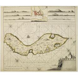
Nieuwe Afteekening van het Eyland Curacao vertoonende alle desselfs geleegentheden mitsgaders de haven van St. Anna en 't Fort Amsterdam int grood, als ook hoe sig dit Eyland uyt der zee vertoont
Decorative and extremely rare of Curaçao with several coastal insets and an inset of Fort Amsterdam and the Bay of St.Anna (127x135mm.)Besides the island of Curacao, thi...
Date: Amsterdam, 1751
Selling price: ????
Please login to see price!
Sold in 2017
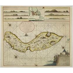
Nieuwe Afteekening van het Eijland Curaçao. . .
Decorative and extremely rare chart of Curaçao with several coastal insets and an inset of Fort Amsterdam and the Bay of St.Anna (127x135mm.)Besides the island of Curacao...
Date: Amsterdam, 1751
Selling price: ????
Please login to see price!
Sold in 2010
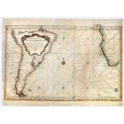
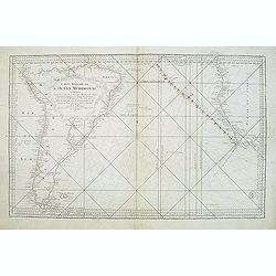
Carte Reduite de L' OCEAN MERIDIONAL Contenant Toutes les Costes de l' Amerique Meridionale. . .
A striking, large sea chart of the Southern Atlantic Ocean, showing most of the coast of South America and the Southwest coast of Africa, published by Nicolas Bellin. The...
Date: Paris, 1753
Selling price: ????
Please login to see price!
Sold in 2019
Karte von dem Abendlaendischen Ocean zur allgemeinen Historie der Reise beschreibungen entworfen von Hrn Bellin..
A nice and decorative map of the Atlantic Ocean.In: Allgemeine Historie der Reisen zur Wasser und zu Lande: oder Sammlung aller Reisebeschreibungen.. in Englischen zusamm...
Date: Leipzig, 1753
Selling price: ????
Please login to see price!
Sold
Carte réduite de l'Océan Méridional: contenant toutes les costes de l'Amérique Méridionale depuis l'Euqater jusqu' au 57 degré de latitude et les costes. . .
Map of Atlantic ocean. Showing the south-east coast of America, the south-west coasts of Africa. In the lower right the sign of the "Depôt de la Marine".Interes...
Date: Paris, 1753
Selling price: ????
Please login to see price!
Sold in 2016

Karte von dem Abenlaendischen Ocean sur allgemeinen Historie der Reife beschreibungen entworfen von Hrn Bellin. . .
Map of the Atlantic Ocean with outlines of the North American continent and the European and African continents.In: Allgemeine Historie der Reisen zur Wasser und zu Lande...
Date: Leipzig, 1753
Selling price: ????
Please login to see price!
Sold in 2008
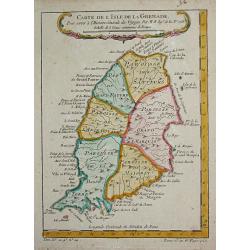
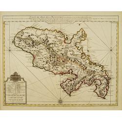
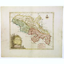
Carte de l' Isle de la Grenade.
Jaques Nicolas Bellin (1702-720) was the most important French hydrographer of the 18th century. Sea-atlas 'Hydrographique Français' , 1756-65, atlas to accompany Prévost...
Date: Paris, c.1755
Selling price: ????
Please login to see price!
Sold
![A NEW CHART of the Vast ATLANTIC OCEAN, Exhibiting The SEAT of WAR, both in EUROPE and AMERICA. [Popple]](/uploads/cache/83196-250x250.jpg)
A NEW CHART of the Vast ATLANTIC OCEAN, Exhibiting The SEAT of WAR, both in EUROPE and AMERICA. [Popple]
A scarce map of the Atlantic with Sailing Routes To New York & Boston. A fine example of Emmanuel Bowen's fascinating broadside map of the Atlantic, which includes a ...
Date: London, 1755
Selling price: ????
Please login to see price!
Sold in 2019
Carte de l?Isle de St. Christofle.
Jaques Nicolas Bellin (1702-720) was the most important French hydrographer of the 18th century. Sea-atlas 'Hydrographique Français' , 1756-65, atlas to accompany Prévost...
Date: Paris, c.1755
Selling price: ????
Please login to see price!
Sold
