Browse Listings in America > Caribbean & Atlantic Ocean > Curaçao
![[Vespucci lands on the Island of Giants.]](/uploads/cache/40474-250x250.jpg)
[Vespucci lands on the Island of Giants.]
In 1499-1500, when Antonio de Ojeda and his crew, including Vespucci, landed on an island known today as Curaçao, they saw giant footprints in the sand. These they follow...
Date: Frankfurt, M.Merian, 1633
Selling price: ????
Please login to see price!
Sold in 2017
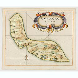
Curacao Eylandt.
One of the earliest separate maps of Curaçao. The map has nice topographical detail and features an ornate title cartouche. The map displays locations of two freshwater s...
Date: Amsterdam, 1644
Selling price: ????
Please login to see price!
Sold in 2025
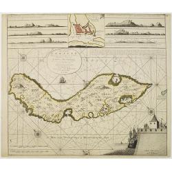
Nieuwe Afteekening van het Eyland Curacao vertoonende alle desselfs geleegentheden mitsgaders de haven van St. Anna en 't Fort Amsterdam int grood, als ook hoe sig dit Eyland uyt der zee vertoont
Decorative and extremely rare of Curaçao with several coastal insets and an inset of Fort Amsterdam and the Bay of St.Anna (127x135mm.)Besides the island of Curacao, thi...
Date: Amsterdam, 1751
Selling price: ????
Please login to see price!
Sold in 2017
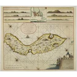
Nieuwe Afteekening van het Eijland Curaçao. . .
Decorative and extremely rare chart of Curaçao with several coastal insets and an inset of Fort Amsterdam and the Bay of St.Anna (127x135mm.)Besides the island of Curacao...
Date: Amsterdam, 1751
Selling price: ????
Please login to see price!
Sold in 2010
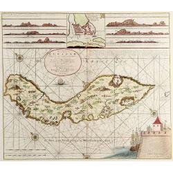
Nieuwe Afteekening van het Eijland Curaçao..
Decorative and extremely rare chart of Curaçao with several coastal insets and an inset of Fort Amsterdam and the Bay of St.Anna (127x135mm.)Besides the island of Curacao...
Date: Amsterdam, 1751
Selling price: ????
Please login to see price!
Sold in 2025
![Kaart van geheel GUAJANA of de WILDEN-KUST, en die der Spaansche Westindien [and] Het Eiland KURASSAU. [and] KAART van de Volkplanting aan DEMERARY en RIO D'ESSEQUEBO.](/uploads/cache/82588-250x250.jpg)
Kaart van geheel GUAJANA of de WILDEN-KUST, en die der Spaansche Westindien [and] Het Eiland KURASSAU. [and] KAART van de Volkplanting aan DEMERARY en RIO D'ESSEQUEBO.
A scarce hand-colored map made from four maps together on one sheet, showing the Dutch colonies on the north coast of South America, including Curaçao and Willemstad. Whi...
Date: Amsterdam, 1765
Selling price: ????
Please login to see price!
Sold in 2019
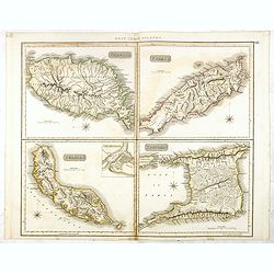
Grenada / Tobago / Curaçao / Trinidad.
A delightfully detailed map of four West Indian islands by John Thomson. The map displays excellent detail concerning each of the islands, including an inset plan of Fort...
Date: Edenburgh, 1821
Selling price: ????
Please login to see price!
Sold in 2016
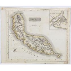
Curaçao.
A delightfully detailed map the West Indian island Curaçao by John Thomson. The map displays excellent detail concerning, including an inset plan of Fort Amsterdam in Cur...
Date: Edenburgh, 1821
Selling price: ????
Please login to see price!
Sold in 2019
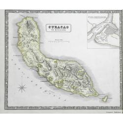
Curacao to Holland.
A detailed map of the island of Curaçao
Date: Liverpool, 1852
Selling price: ????
Please login to see price!
Sold in 2016
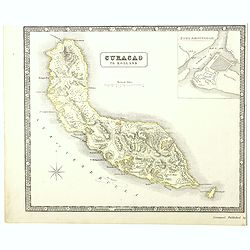
A detailed map of the island of Curaçao.
A detailed map of the island of Curaçao showing settlements, roads, and the topography. An inset shows Fort Amsterdam with the battery, gallows, and fortifications.
Date: Liverpool, George Philip and Son, 1853
Selling price: ????
Please login to see price!
Sold in 2022
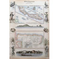
Dutch Possessions in South America and the West Indies.
Large sheet with two maps showing Dutch possessions in the Caribbean and South America. The top map shows Curaçao in large scale, also Saba, and St. Martin. The bottom ma...
Date: London, c1860
Selling price: ????
Please login to see price!
Sold in 2015
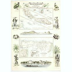
Dutch Possessions in South America and the West Indies.
Two maps are shown: one of the island of Curaçao with insets of the Leeward and the Lesser Antilles and a map of the northern part of Dutch Guyana with insets of a plan o...
Date: London, 1860
Selling price: ????
Please login to see price!
Sold in 2020
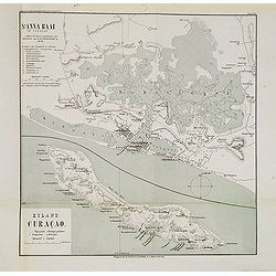
St. Anna Baai op Curaçao. / Eiland Curaçao.
Very detailed (1:20.000) lithographed map of St. Anna Bay, including Willemstad with the historic center of the city with Punda and Otrobanda. on the island Curaçao as su...
Date: Amsterdam-Utrecht, K.N.A.G./ C.L.Brinkman, J.J.Beijers, 1882
Selling price: ????
Please login to see price!
Sold in 2013
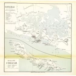
St. Anna Baai op Curaçao. / Eiland Curaçao.
Very detailed (1:20.000) lithographed map of St. Anna Bay, including Willemstad with the historic center of the city with Punda and Otrobanda. on the island Curaçao as su...
Date: Amsterdam-Utrecht, K.N.A.G./ C.L.Brinkman, J.J.Beijers, 1882
Selling price: ????
Please login to see price!
Sold in 2015
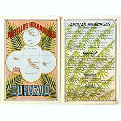
Antilla Holandesas. Curazao.
Unique manuscript map of Curaçao, Bonaire, and Aruba. Award-winning manuscript card, prepared by Antonio Raggio for the 11th Congreso de la Union Postal Universal (World ...
Date: Buenos Aires, 1939
Selling price: ????
Please login to see price!
Sold in 2018
