Browse Listings in America > Caribbean & Atlantic Ocean > Caribbean other islands
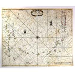
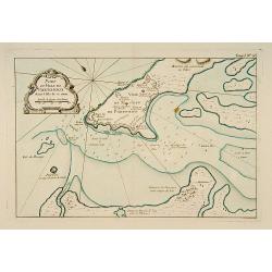
Pascaert Vande Caribes Eylanden.
A fine seventeenth century sea chart of the islands of the Caribbean, including Puerto Rico, the Virgin Islands, Barbados, Guadeloupe, Trinidad, Tobago, the Lesser Antill...
Date: Amsterdam, 1666
Selling price: ????
Please login to see price!
Sold in 2016
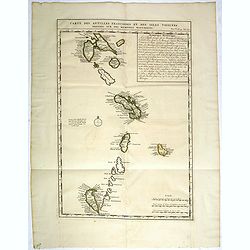
Carte des Antilles Françoises et des Isles voisines dressée sur des Mémoires Manuscrits.
Map of the West Indies Islands, with descriptive French text, from Chatelain's monumental 7 volume "Atlas Historique".Henri Abraham Chatelain (1684 – 1743) was ...
Date: Amsterdam, 1720
Selling price: ????
Please login to see price!
Sold in 2017
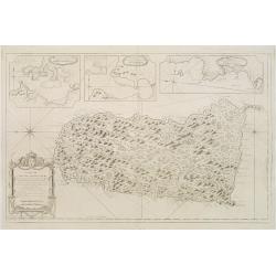
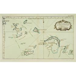
![[Five maps on one sheet] Dominia Anglorum in praecipuis Insulis Americae ut sunt Insula S. Christopheri, Antegoa, Iamaica, Barbados nec non Insula Bermudes vel Sommers . . .](/uploads/cache/25265-250x250.jpg)
[Five maps on one sheet] Dominia Anglorum in praecipuis Insulis Americae ut sunt Insula S. Christopheri, Antegoa, Iamaica, Barbados nec non Insula Bermudes vel Sommers . . .
Interesting set of 5 maps on a single sheet, showing Jamaica, Bermuda, Antigua, Barbados and St. Kitts. With a large decorative title cartouche. Each map is very detailed...
Date: Nuremberg, 1740
Selling price: ????
Please login to see price!
Sold in 2008
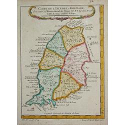
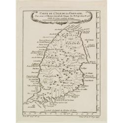
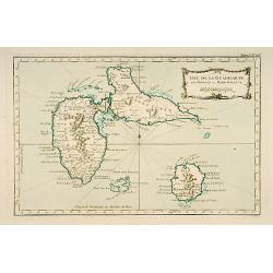
Carte de l' Isle de la Grenade.
Jaques Nicolas Bellin (1702-720) was the most important French hydrographer of the 18th century. Sea-atlas 'Hydrographique Français' , 1756-65, atlas to accompany Prévost...
Date: Paris, c.1755
Selling price: ????
Please login to see price!
Sold
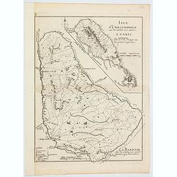
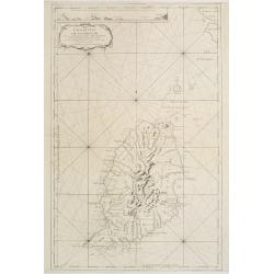
Isle St. Christophle. . ../ La Barbade. . .
Two maps on one sheet: top - St.Christopher and bottom - Barbados. George Louis Le Rouge was active from 1740 until 1780 as a publisher, and was appointed engineer for th...
Date: Paris, 1757
Selling price: ????
Please login to see price!
Sold in 2020
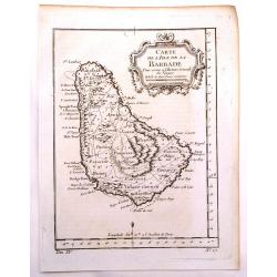
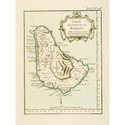
Carte de L'isle de la Barbade.
One of the finest early maps or charts of Barbados. The island is divided into parishes and details cities & towns, mountains, forests, anchorages, shoals, rocks, etc...
Date: Paris, 1758
Selling price: ????
Please login to see price!
Sold in 2017
Carte de L'Isle de la Barbade Dressee au depost des cartes et plans de la marine..
This large scale coastal chart of Barbados, with hand-coloring, large decorative cartouche. Bellin (1703-1772) began working for the newly established Dépôt des Cartes et...
Date: Paris 1758
Selling price: ????
Please login to see price!
Sold
Carte de l'Isle de la Grenade..
This chart shows the island Grenada. It contains an inset coastal profile and numerous rhumb linesJacques Nicolas Bellin (1703-1772) was one of the most important and pro...
Date: Paris 1760
Selling price: ????
Please login to see price!
Sold
Carte de l'Isle de Sainte Lucie..
Attractive double page chart of St. Lucia with inset plans ('Port du Carenage', Cul de sac des Roseaux' and 'Mouillages du Grand Islet et du Choc', illustrating some deta...
Date: Paris 1763
Selling price: ????
Please login to see price!
Sold in 2008
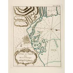
Plan du Port-au-Prince dans l'Isle de St Domingue.
This chart shows the territories of the town of Port-au-Prince on the island St Domingue.The only issue of this version of Bellin's map, slightly larger than the common v...
Date: Paris 1764
Selling price: ????
Please login to see price!
Sold
![Suite des Isles Antilles 2.Partie. Together with 2.Partie [2 maps].](/uploads/cache/17123-250x250.jpg)
Suite des Isles Antilles 2.Partie. Together with 2.Partie [2 maps].
These set of 2 chart are showing the Antilles Islands of Guadeloupe, Dominique, Martinique, Grenada, St.Vincent and St. Lucie.The only issue of this version of Bellin's m...
Date: Paris 1764
Selling price: ????
Please login to see price!
Sold
Carte de l'Isle de la Grenade, Pour servir?
Detailed map of the island Grenada by Jacques Nicolas Bellin (1703-1772), one of the most important and proficient French cartographers of the mid-eighteenth century.He w...
Date: Paris 1764
Selling price: ????
Please login to see price!
Sold
Plan du Cul de Sac des Roseaux dans l'Isle de Ste. Lucie.
This chart shows the territories of Cul de Sac des Roseaux on the island of Saint Lucie. The only issue of this version of Bellin's map, slightly larger than the common v...
Date: Paris 1764
Selling price: ????
Please login to see price!
Sold
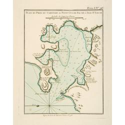
Plan du Port du Carenage ou Petit Cul de Sac de l'Isle Se Lucie.
This chart shows the territories of the harbour of Carenage or Petit Cul de Sac on the island of Sant Lucie.The only issue of this version of Bellin's map, slightly large...
Date: Paris 1764
Selling price: ????
Please login to see price!
Sold
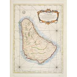
Carte de l'Isle de la Barbade.
This chart shows the island Barbados.The only issue of this version of Bellin's map, slightly larger than the common version. Depths shown by soundings.From Bellin's Peti...
Date: Paris 1764
Selling price: ????
Please login to see price!
Sold
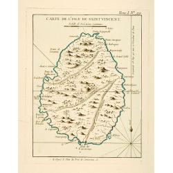
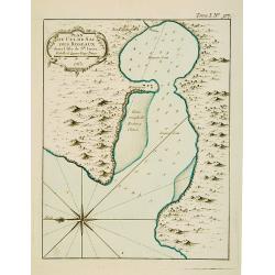
Carte de l'Isle de Saint Vincent.
This chart shows the island of St. Vincent The only issue of this version of Bellin's map, slightly larger than the common version. Depths shown by soundings.From Bellin'...
Date: Paris 1764
Selling price: ????
Please login to see price!
Sold
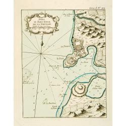
Port et Fort Royal de la Grenade.
This chart shows the territories of the harbour and fortress Royal on the island of Grenada.The only issue of this version of Bellin's map, slightly larger than the commo...
Date: Paris 1764
Selling price: ????
Please login to see price!
Sold
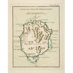
Carte de l'Isle de Marie-Galante.
This chart shows the territories of Isle Marie-Galante The only issue of this version of Bellin's map, slightly larger than the common version. Depths shown by soundings....
Date: Paris 1764
Selling price: ????
Please login to see price!
Sold
Carte de l'Isle de Saint-Christophe.
This chart shows the island of St. Kitts. Shows interesting topographic details, notes, ports, anchorages, etc.The only issue of this version of Bellin's map, slightly la...
Date: Paris 1764
Selling price: ????
Please login to see price!
Sold
Isle de Guadeloupe les Saintes et Marie Galante.
This chart shows the islands of Guadeloupe, Les Saintes et Marie Galante.The only issue of this version of Bellin's map, slightly larger than the common version. Depths s...
Date: Paris 1764
Selling price: ????
Please login to see price!
Sold
![Partie occidentale de l'Isle de la Guadeloupe appellée la Basse Terre. / Partie Orientale de l'Isle de la Guadeloupe.. [2 maps]](/uploads/cache/17051-250x250.jpg)
Partie occidentale de l'Isle de la Guadeloupe appellée la Basse Terre. / Partie Orientale de l'Isle de la Guadeloupe.. [2 maps]
A set of 2 maps showing the northern and southern islands of Guadeloupe.The only issue of this version of Bellin's maps, slightly larger than the common version. Depths s...
Date: Paris 1764
Selling price: ????
Please login to see price!
Sold
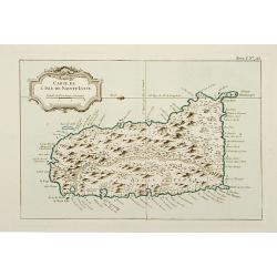
Carte de l'Isle de Sainte Lucie.
This chart shows the island Saint Lucie.The only issue of this version of Bellin's map, slightly larger than the common version.From Bellin's Petit atlas maritime.Tome I ...
Date: Paris 1764
Selling price: ????
Please login to see price!
Sold
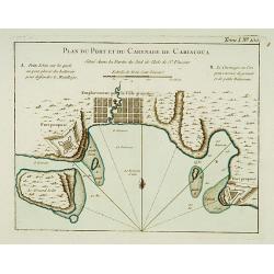
Plan du Port et du Carenage de Cariacoua.
A map of the proposed city and harbour of Carenage de Cariacoua, on the island of St. Vincent.The only issue of this version of Bellin's map, slightly larger than the com...
Date: Paris 1764
Selling price: ????
Please login to see price!
Sold
Port et Ville de Porto-Rico dans l'Isle de ce nom.
This chart shows the territories of the harbour and town of "Porto Rico" on St. Jean Island, St. John. The only issue of this version of Bellin's map, slightly ...
Date: Paris 1764
Selling price: ????
Please login to see price!
Sold
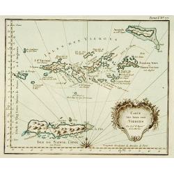
Carte des isles des vierges.
This chart shows the Virgin Islands with island Saint Croix.The only issue of this version of Bellin's map, slightly larger than the common version.From Bellin's Petit at...
Date: Paris 1764
Selling price: ????
Please login to see price!
Sold
Carte de l'Isle St-Thomas l'Une des Vierges.
This chart shows the island St-Thomas.The only issue of this version of Bellin's map, slightly larger than the common version. Depths shown by soundings.From Bellin's Pet...
Date: Paris 1764
Selling price: ????
Please login to see price!
Sold
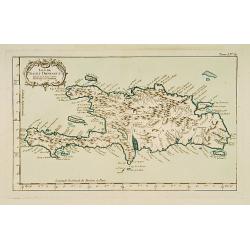
Isle de St Domingue.
This chart shows the island St Domingue.The only issue of this version of Bellin's map, slightly larger than the common version. Depths shown by soundings.From Bellin's P...
Date: Paris 1764
Selling price: ????
Please login to see price!
Sold
Carte des Isles situées au Nord de St Domingue Avec les Passages pour le retour appellés Débouquemens.
This chart shows the territories of the Caicos Islands and Acklins islands, north of St. Domingue.The only issue of this version of Bellin's map, slightly larger than the...
Date: Paris 1764
Selling price: ????
Please login to see price!
Sold
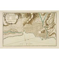
Ville du Cap dans l'Isle de St Domingue.
This chart shows the territories of city of Cap in Isle of St Domingue. Engraved by Croisey.The only issue of this version of Bellin's map, slightly larger than the commo...
Date: Paris 1764
Selling price: ????
Please login to see price!
Sold
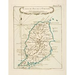
Carte de l'Isle de la Grenade.
This chart shows the island Granada.The only issue of this version of Bellin's map, slightly larger than the common version. Depths shown by soundings.From Bellin's Petit...
Date: Paris 1764
Selling price: ????
Please login to see price!
Sold
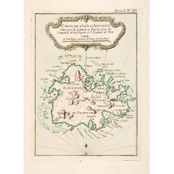
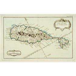
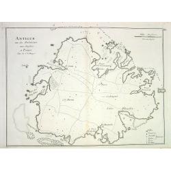
Carte de l'Isle d'Antigue Située par la Latitude 17 Degrés et par la Longitude de 64 Degrés à l'Occident de Paris
This chart shows the island of Antigua.The only issue of this version of Bellin's map, slightly larger than the common version. Depths shown by soundings.From Bellin's Pe...
Date: Paris 1764
Selling price: ????
Please login to see price!
Sold
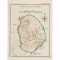
Carte de l'Isle de Nieves.
This chart shows the island of Nieves. The only issue of this version of Bellin's map, slightly larger than the common version. Depths shown by soundings.From Bellin's Pe...
Date: Paris 1764
Selling price: ????
Please login to see price!
Sold
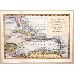
The West Indies Exhibiting the English French Spanish Dutch & Danish Settlements with the Adjacent Parts of North & South America from the Best Authorities
This is a fine map of the Caribbean showing the colonial holdings of Britain, France, Spain, the Netherlands and Denmark after the Treaty of Peace in 1783, by way of a k...
Date: London, 1768
Selling price: ????
Please login to see price!
Sold in 2016
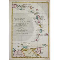
Supplément pour les Isles Antilles.
Rigobert Bonne (1727-1795), French cartographer. His maps are found in a.o. Atlas Moderne (1762), Raynal's Histoire Philos. du Commerce des Indes (1774) and Atlas Encyclo...
Date: Paris, c. 1770
Selling price: ????
Please login to see price!
Sold
Carte des Isles Antilles ou du Vent avec la Partie orientale des Isles sous le Vent.
Rigobert Bonne (1727-1795), French cartographer. His maps are found in a.o. Atlas Moderne (1762), Raynal's Histoire Philos. du Commerce des Indes (1774) and Atlas Encyclo...
Date: Paris, 1774
Selling price: ????
Please login to see price!
Sold
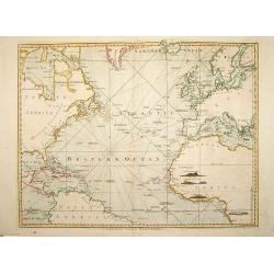
A Chart of the Atlantic Ocean. 1 sheet.
A very fine chart centered on the Atlantic ocean, including a part of western Europe and America continent. London: Printed and sold by Robert Sayer, No. 53 in Fleet Stre...
Date: London, 1775
Selling price: ????
Please login to see price!
Sold in 2008
Antigue une des Antilles aux Anglois...
Detailed copper-engraved chart of Antigua, showing ports, anchor spots, reefs, roads, forts and towns. With key and distance scale.
Date: Paris, 1778
Selling price: ????
Please login to see price!
Sold in 2008
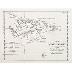
Carte de Maidenland ou de la Virginie de Hawkins.. Et du Canal Falkland..
Fine chart of the Falkland Islands called Maidenland or Virginie by Sir Richard Hawkins who discovered the islands in 1574.Also shows the Canal Falkland, the Strait betwe...
Date: Paris 1780
Selling price: ????
Please login to see price!
Sold
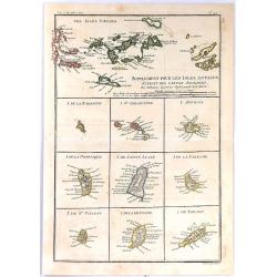
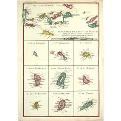
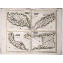
Supplement Pour Les Isles Antilles, Extract des Cartes Angloises
At the top of this interesting group of maps are the Virgin Islands, and below them are nine small maps of Barbuda, Barbados, St Vincent, St. Kitts, Antigua, Dominica, Sa...
Date: Paris, 1780
Selling price: ????
Please login to see price!
Sold in 2017
West India Islands - Martinico & Dominica.
Two maps of West India Islands including Martinico and Dominica. Features an inset of cul de Sac Royal (Modern day Fort-de France). Issued in Thomson's "NEW GENERAL ...
Date: Edinburgh, 1817
Selling price: ????
Please login to see price!
Sold in 2015
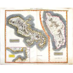
West India Islands.
Map of four islands in the Caribbean: Grenada. Tobago. Trinidad. Curacao (with) Fort Amsterdam.Title above: 'West India Islands'. At bottom centre: 'Drawn & engraved ...
Date: Edinburgh, London, Dublin, 1816/1817
Selling price: ????
Please login to see price!
Sold in 2022
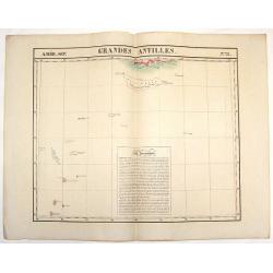
Amer. Sep. Grandes Antilles. No. 73.
Large lithographed map featuring the southern portion of the Grand Antilles Islands including the Banc Pedro Group. This map is part of Vandermaelen's world maps produced...
Date: Brusselles, 1827
Selling price: ????
Please login to see price!
Sold in 2018
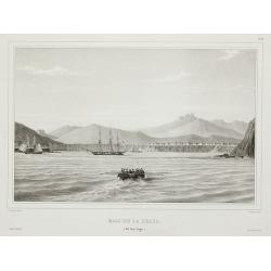
Baie de la praya. (Ile San lago.).
View of the Cape Verde from Voyage de la corvette l’Astrolabe exécuté par Ordre du Roi pendant les années 1826 – 1827 – 1828 – 1829 sous le commandement de M. Jules Dumon...
Date: Paris, 1830
Selling price: ????
Please login to see price!
Sold in 2011
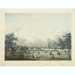
Port Louis à l'ile de France. (Mauritius)
Aquatint by Sigismond Himely (1801-1872) after Walter Paris (fl.1849-1891) published in "Laplace, Voyage autour du monde" by Sainson. Rare view of Port Louis on...
Date: Paris, 1835
Selling price: ????
Please login to see price!
Sold in 2011
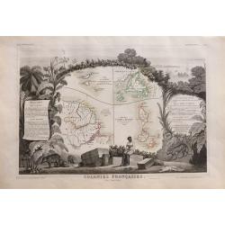
Colonies Françaises (en Amérique).
Beautiful map from one of the finest decorative atlases of the nineteenth century. A highly decorative 19th century map showing the islands of St Martin, St Pierre et Miq...
Date: Paris 1856
Selling price: ????
Please login to see price!
Sold in 2016
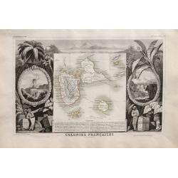
Colonies Francaises en Amérique: Guadeloupe, Marie-Galante, St Martin, La Désirade, Les Saintes, Anguilla.
Beautiful map from one of the finest decorative atlases of the nineteenth century. A highly decorative 19th century map showing the islands of Guadeloupe, Marie-Galante, ...
Date: Paris 1856
Selling price: ????
Please login to see price!
Sold in 2016
!["Nederlandsch West - Indië. [7 maps on one sheet, including Curaç.]"](/uploads/cache/15951-250x250.jpg)
"Nederlandsch West - Indië. [7 maps on one sheet, including Curaç.]"
"An excellent engraving of the Dutch possessions in the West Indies. Seven maps on one sheet, Surinam, St. Martin, Bonaire, Curaç, Aruba, St.Eustatius and...
Date: The Netherlands c.1900
Selling price: ????
Please login to see price!
Sold
