Subscribe to be notified if similar examples become available.
Plano de la Ciudad de Puerto Real, En La Isla De La Jamaica Segun Bontein y la copia de Bellin: Por D. Juan Lopez |
||||||||||||||||||||
|
||||||||||||||||||||
|
|
||||||||||||||||||||
|
Selling price: $ Please login to see price!
Sold in 2023 Missed this item! Add your name to our mailing list and be the first to get notified about our newly added listings. . |
My Collection +
Add this or any of your favorite items in one place. If you want to save the items permanently, you have to sign in or create an account first.
Watchers:
4
|
|||||||||||||||||||
Description
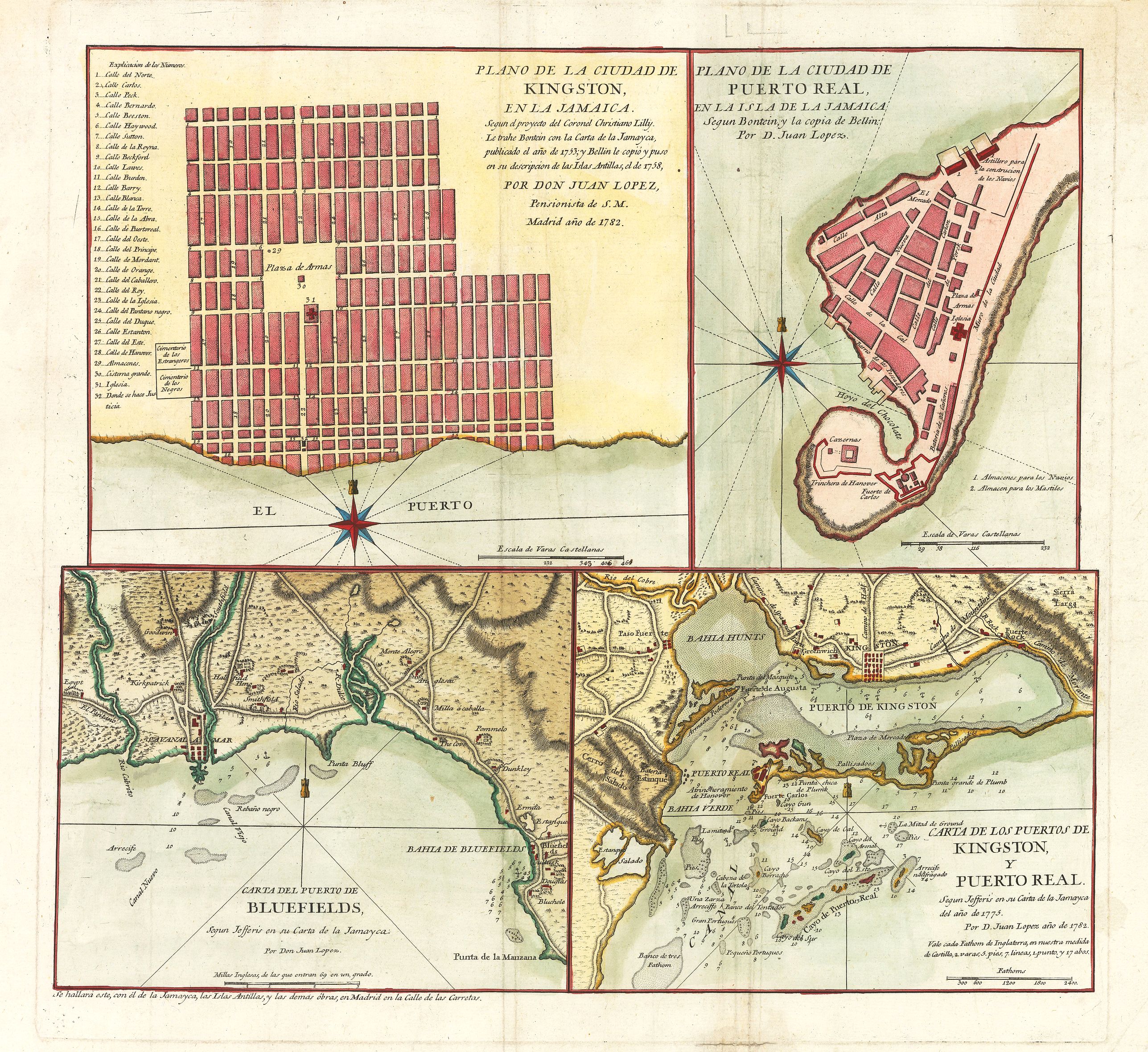
This scarce work features a set of four Spanish maps on one sheet depicting Spanish towns and harbor plans of important Jamaican ports.
Spanish settlement of Jamaica began in the late 15th century, following the exploratory expeditions of Christopher Columbus. The island quickly became a major centre for sugar production, built on the back of slave labor. It was also of strategic importance and served as a central base for Spain in the Caribbean until 1655 when England seized control. Cartographic elements found throughout the maps include the location of roads and dwellings, scales, soundings, sea banks or shoals, compass roses, and some topographical details.
Plano de la Ciudad de Kingston in la Jamaica
The map in the upper left quadrant depicts the city of Kingston, Jamaica. The city was founded in 1693 following the 1692 earthquake which devastated Port Royal, which had previously been the centre of commerce. It shows the grid plan which was used for better organizing the city in the early 18th century with an eye to commerce, with the port to the south of the city proper. A large central plaza is indicated to have a cistern. The map is number coded, with all streets named, and important buildings, landmarks, etc., denoted.
Port Royal, Jamaica
The map in the upper right quadrant features the city of Port Royal, founded in 1494 and once the largest city in the Caribbean, functioning as a center of commerce and shipping. The city was completely destroyed by earthquake in 1692, a natural catastrophe which many perceived to be an act of divine retribution for the city’s having been a haven for pirates, brigands and slave traders. The map is highly detailed, with streets named, major building and fortifications denoted, and elevations shown by hachures. It has a decorative compass rose with a tower on a rhumb line denoting north.
Blue Fields, Jamaica
The map in the lower left quadrant features the port of Blue Fields, located in the west of the island. Blue Fields, built by the Spanish in the early 17th century, is one of the oldest settlements on the island. It was chosen for its protected anchorage and abundant fresh water. Following the conquest of the island by the British, the port’s importance waned, but the bay became popular with pirates. The map includes shoals and depth soundings in the bay, along with river systems that empty into the bay.
Kingston and Port Royal, Jamaica
The final map of the four, located in the lower right quadrant, shows both Kingston and Port Royal and their environs. The map is highly detailed, with river systems, topography indicated in hachures, and with shoals and shallows and depth soundings in the water. This final map of the four visually illustrates the perfect landscape of the area which served as such a trade hub for so long. This map also includes depth soundings and shoals, river systems which flow into the bays, and much topography of the area.
FAQ - Guarantee - Shipping
994 BuyBidBuying in the BuyNow Gallery
This item is available for immediate purchase when a "Add to Cart" or "Inquire Now" button is shown.
Payments are accepted in Euros or US Dollars. We accept most major credit cards, PayPal and bank transfer.
Authenticity Guarantee
 We provide professional descriptions, condition report and HiBCoR rating (based on 45 years experience in the map business)
We fully guarantee the authenticity of items we sell. We provide a certificate of authenticity for each purchased item.
Condition / Coloring
We indicate the condition of each item and use our unnique HiBCoR grading system in which four key items determine a map's value: Historical Importance, Beauty, Condition/Coloring and Rarity.
We offer many maps in their original black and white condition. We do not systematically color-up maps to make them more sellable to the general public or buyer.
Copper engraved or wood block maps are always hand colored. Maps were initially colored for aesthetic reasons and to improve readability. Nowadays, it is becoming a challenge to find maps in their original colors and are therefor more valuable.
We use the following color keys in our catalog:
Original colors; mean that the colors have been applied around the time the map was issued.
Colored; If the colors are applied recently or at the end of the 20th century, then "colored", or "attractive colors" will be used.
Original o/l colors; means the map has only the borders colored at the time of publication.
Read more about coloring of maps [+]
FAQ
Please have a look for more information about buying in the BuyNow gallery.
Many answers are likely to find in the general help section.
My Collection+
![]()
With My Collection+ you can collect all your favorite items in one place. It is free, and anyone can create his or her virtual map collection.
Unless you are logged in, the item is only saved for this session. You have to be registed and logged-in if you want to save this item permanently to My Collection+.
Read More [+]
If you want to save the items permanently, please sign in
or create account first. ![]()
Registering Here, it is and you do not need a credit card.
Add this item to
My Collection+
or click the following link to see My Collection+.
Invoice
The invoice and certificates of authenticity are available in the client center >Invoices
| Digital Image Download | |
|
Paulus Swaen maintains an archive of most of our high-resolution rare maps, prints, posters and medieval manuscript scans. We make them freely available for download and study. Read more about free image download |
Click the image for a free small image download. |
In accordance with the EU Consumer Rights Directive and habitually reside in the European Union you have the right to cancel the contract for the purchase of a lot, without giving any reason.
The cancellation period will expire 14 calendar days from the day after the date on which you or a third party (other than the carrier and indicated by you) acquires, physical possession of the lot. To exercise the right to cancel you must inform Paulus Swaen Inc, of your decision to cancel this contract by a clear statement (e.g. a letter sent by post, or e-mail.
To meet the cancellation deadline, it is sufficient for you to send your communication concerning your exercise of the right to cancel before the cancellation period has expired.
