Browse Listings in Asia
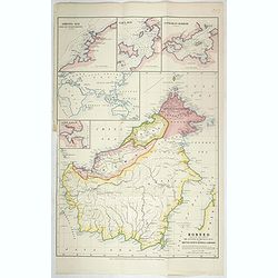
Borneo, shewing the lands ceded by the sultans of Brunei & Sulu to the British North Borneo Company.
Chromo lithographed folded map showing Borneo with Brunei, Sarawak, British North Borneo Company or Sabah. One of the first maps showing the British North Borneo Company ...
- $1750 / ≈ €1529
Date: London, Stanford, 1881
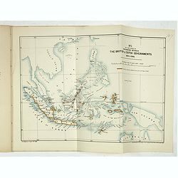
Papers relating to the affairs of Sulu and Borneo, and to the grant of a charter of incorporation of the British North Borneo Company. . . (with two folding maps of Indonesia)
58 pages Government recordings relating to the affairs of Sulu and Borneo, and to the grant of a charter of incorporation of the British North Borneo Company. . . (includ...
- $500 / ≈ €437
Date: London, Harrison and son, 1882

Oro-Hydrographische Kaart van Azië.
One of the earliest thematic maps of Asia published in the Netherlands from "Atlas der natuurkundige aardrijkskunde. . .". prepared by Nicolaas Wilhelmus Posthu...
- $35 / ≈ €31
Date: Amsterdam, C.L. Brinkman, 1883
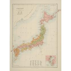
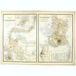
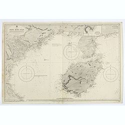
Japan.
A detailed lithographed map of Japan including Hokkaido and including a small inset of the environs of Tokyo & Yokohama. Lower part map a numbered key to divisions an...
- $200 / ≈ €175
Date: Edinburg, 1884
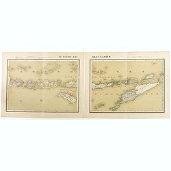
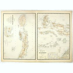
De kleine Soenda-Eilanden. Schaal van 1:800000.
Very detailed two sheet map of Soenda Islands, taken from "Atlas van Nederlandsch Oost- en West-Indie", prepared by doctor I. Dornseiffen, and published by publ...
- $30 / ≈ €26
Date: Amsterdam, Seyffardt, 1884
Kaart van Celebes / Kaart van Zuid-West-Celebes : bevattende de Gouvernem.ts, de leenroerige en een gedeelte der bondgenootschappelijke landen behoorende tot het Gouvernement van Celebes en onderh.
Very detailed map taken from "Atlas der Nederlandsche bezittingen in Oost-Indië", who was published by Departement van Koloniën".First edition of one of ...
- $50 / ≈ €44
Date: The Hague, 1883-1885
Kaart van't noordwestelijke gedeelte der Residentie Amboina . . . / Kaart der Molukken.
Two very detailed maps on one sheet, taken from "Atlas der Nederlandsche bezittingen in Oost-Indië", who was published by Departement van Koloniën".The m...
- $75 / ≈ €66
Date: The Hague, 1883-1885
![[Title page] Der Nederlandsche Bezittingen in Oost-Indië . . .](/uploads/cache/37336-250x250.jpg)
[Title page] Der Nederlandsche Bezittingen in Oost-Indië . . .
Decorative title page with, in the lower part, a schematic map of Indonesia, and two hemispheres. Taken from "Atlas der Nederlandsche bezittingen in Oost-Indië"...
- $75 / ≈ €66
Date: The Hague, 1883-1885

Geological Survey of Japan. Reconnaissance map. Geology. Division 1. 2. 3. 4.
According to Original Surveys and Designs by Dr. Edmund Naumann ; assisted by Takao Fujitani, Akira Yamada, Ichitaro Ban, Shogo Nishiyama ; engraved by S. Takenouchi, K. ...
- $1500 / ≈ €1310
Date: Tokyo, Toyodo Engraving Office, 1886
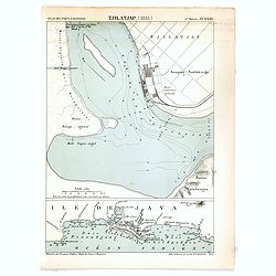
Tjilatjap (1888)
Detailed plan of the port and city of Tjilatjap on Java. Taken from "Atlas des Ports Etrangers". Lithographed by A. Simon.
Date: Paris, 1888
![Parthie aus dem Binnensee [Japan]](/uploads/cache/01312-250x250.jpg)
Parthie aus dem Binnensee [Japan]
Anonymous drawing made by a German during his visit to Japan. The drawing shows a lake with two Japanese vessels and a building with a Japanese flag in an mountainous lan...
- $150 / ≈ €131
Date: Japan, c. 1890
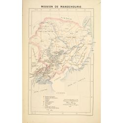
Mission de Mandchourie.
Important missionary map showing Manchuria in Russia and China, prepared by Adrien Launay, who was a French Missionary and later chronicler of the history of the French M...
- $100 / ≈ €87
Date: Lille, 1890
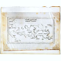
Hayter Basilisk, and Moresby Islands. (manuscript map)
An unusual small, and basic manuscript map of the Hayter Basilisk and Moresby Islands near Papua New Guinea, off the northern coast of Australia.
- $100 / ≈ €87
Date: London, ca. 1890
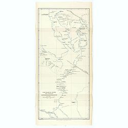
The Karun River and branches.
Karun River and branches map compiled from the charts of Colonel Chesney, Lieut. Selby and Captain Clements.The Karun continues toward the Persian Gulf, forking into two ...
Date: London, 1890
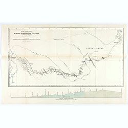
Across Luristan to Ispahan.
Map showing the route from Shushter to Ispahan by Henry Blosse Lynch. When Lynch was based in Baghdad he was in charge of the postal service across Syria between Baghdad ...
Date: London, 1890
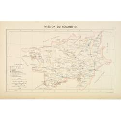
Mission du Kouang-Si.
Important missionary map showing part of China, prepared by Adrien Launay, who was a French Missionary and later chronicler of the history of the French Missions in Indo-...
Date: Lille, 1890
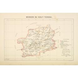
Mission du Kouy-Tcheou.
Important missionary map showing part of China, prepared by Adrien Launay, who was a French Missionary and later chronicler of the history of the French Missions in Indo-...
Date: Lille, 1890
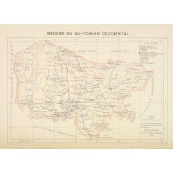
Mission du Sin-Tchuen occidental.
Important missionary map showing part of China, prepared by Adrien Launay, who was a French Missionary and later chronicler of the history of the French Missions in Indo-...
Date: Lille, 1890
![[Views of Korea, Thailand, Cambodia and its inhabitants and princes. Including one or more phographes by Hippolyte Frandin.]](/uploads/cache/48426-250x250.jpg)
[Views of Korea, Thailand, Cambodia and its inhabitants and princes. Including one or more phographes by Hippolyte Frandin.]
A collection of 95 photographs, of which about 60 photos feature Korea or its people, printed on albumen paper. Captions in French. The others from Thailand, China, India...
- $25000 / ≈ €21839
Date: C. 1892
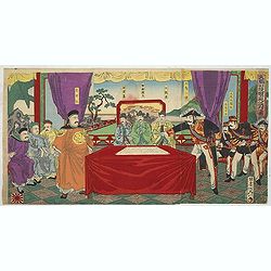
Chosen Danpan (Discussing the clauses of the ultimatum between the Japanese, Chinese and Korean forces).
Japanese woodcut showing the Japanese, Chinese and Koreans discussing the clauses of the ultimatum between Japan, China and Korea, . Yôsai Nobukazu (1872-1944).A scene...
- $1200 / ≈ €1048
Date: August 8, MEIJI 27th year or 1894
Colombo Harbour From Surveys supplied by Sir. John Coode. . .
Sir John Coode's highly detailed map of the Harbour at Colombo (Sri Lanka), with manuscript notations and corrections in pencil. With red pencil "INCORRECT".The...
- $500 / ≈ €437
Date: London, 1885 -1896
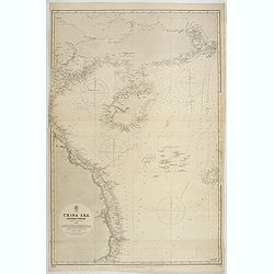
China Sea Nothern Porton compiled from the latest survey to 1884
A fine Survey chart no. 2680 showing Tong King Gulf, Hanan Island up to Hong Kong, Macao and Canto River up to Canton (Being)
- $800 / ≈ €699
Date: London, 1887, updated to 1897
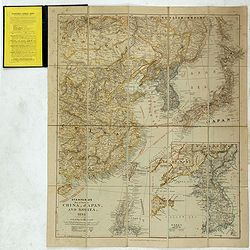
Stanford's Map of Eastern China, Japan and Korea. 1898.
Charming, folding map of the east coast of China, Korea and Japan. In the lower right corner inset map of Korea (265x512mm.). In the lower left, a key to Treaty Ports, Su...
- $750 / ≈ €655
Date: London, ca. 1898
![[South and middle Asia and the lands of the Nile.].](/uploads/cache/46144-250x250.jpg)
[South and middle Asia and the lands of the Nile.].
Alexey Afinogenovich Ilyin was a lieutenant general and cartographer (1832-1889). In 1856, after graduating from the Academy of the General Staff, he was at the military ...
- $100 / ≈ €87
Date: St. Petersburg, 1899
![[Asia].](/uploads/cache/46145-250x250.jpg)
[Asia].
Alexey Afinogenovich Ilyin was a lieutenant general and cartographer (1832-1889). In 1856, after graduating from the Academy of the General Staff, he was at the military ...
- $100 / ≈ €87
Date: St. Petersburg, 1899
![[Europe].](/uploads/cache/46154-250x250.jpg)
[Europe].
Alexey Afinogenovich Ilyin was a lieutenant general and cartographer (1832-1889). In 1856, after graduating from the Academy of the General Staff, he was at the military ...
- $100 / ≈ €87
Date: St. Petersburg, 1899
![[Map of Palestine].](/uploads/cache/46175-250x250.jpg)
[Map of Palestine].
Alexey Afinogenovich Ilyin was a lieutenant general and cartographer (1832-1889). In 1856, after graduating from the Academy of the General Staff, he was at the military ...
- $100 / ≈ €87
Date: St. Petersburg, 1899
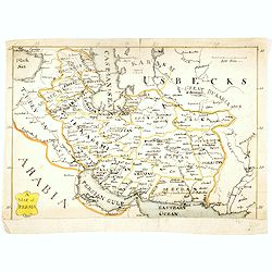
A map of Persia.
Manuscript map of Persia, including Armenia, Georgie, Caspian Sea, etc.
- $250 / ≈ €218
Date: ca. 1900
Peking. ( Pictorial map)
This pictorial map of this Game of the Goose, published at the time of the Boxer War, shows well the situation of Pei-Ho and Tientsin in relation to Peking. There are 42 ...
- $600 / ≈ €524
Date: France, ca.1901
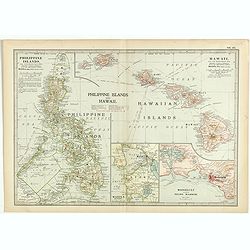
Philippine Islands and Hawaii.
Map of Philippine Islands and Hawaii, with inset maps of Manila, Honolulu, and Pearl Harbor, circa 1902, from the 10th edition of Encyclopaedia Britannica.
- $40 / ≈ €35
Date: London, ca. 1902
![Wusung River or Hwang Pu. / Wusung River Entrance [With Shanhhai]](/uploads/cache/48595-250x250.jpg)
Wusung River or Hwang Pu. / Wusung River Entrance [With Shanhhai]
A fine Survey chart no. 1601 showing Wusung River or Hwang Pu. / Wusung River Entrance [With Shanghai]
- $800 / ≈ €699
Date: London, 1887 - 190, updated to 1903
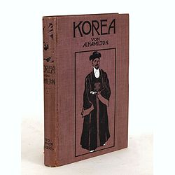
Korea. Das Land des Morgenrots. Nach seinen Reisen geschildert von Angus Hamilton. Autorisierte Übersetzung aus dem Englischen.
With 114 illustrations after photographes and one map.
- $175 / ≈ €153
Date: Leipzig: Spamer, 1904
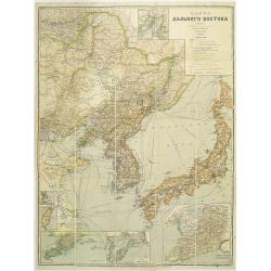
Map of the Far East
rare map including, Corea, Japan and China, prepared by Leonid Ivanovich Borodovsky, (1870-1906) and published in 1904. This folding map has several insets, one with Tai...
- $1000 / ≈ €874
Date: St. Petersburg, A.Ilyin, 1904

L'illustration, journal officiel hebdomadaire.
L'Illustration, the first French illustrated newspaper from 1843, became the first magazine in the world in 1906 and is distributed in more than 150 countries.The mythica...
Date: Paris, 1908
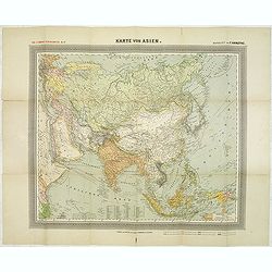
General Karte von Asien. Entworfen und gezeichnet von F. Handtke.
In upper left corner "Carl Flemmings Generalkarten No. / Nr. 37" in a 17th edition. Prepared by Friedrich Handtke (1815-1879). Scale 1: 18.886.000, with a key i...
Date: Glogau, Carl Flemming, c.1910
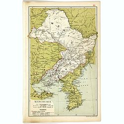
Manchuria.
Map of Manchuria and Korea. With in lower left corner scales in miles and kilometers, Protestant Mission Stations, railways both opened and in progress, canals and telegr...
- $75 / ≈ €66
Date: London, 1910
Boucle du Pei-Ho.
Manuscript map of Boucle du Pei-Ho (Taku Forts) showing the river Pei-ho, along with the projected railway lines were to be built, including bridges, installations, villa...
- $750 / ≈ €655
Date: China ?, ca.1910
![[Map of Turkey in Ottoman script]](/uploads/cache/40765-250x250.jpg)
[Map of Turkey in Ottoman script]
Map of Turkey, including Cyprus, with text in Ottoman script. In the bottom a color key to the different regions. Published by Elbemühl Graphische Industrie in Vienna (f...
Date: Vienna, ca. 1915
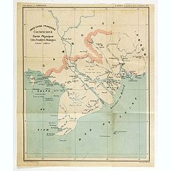
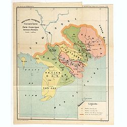
Indo-Chine Française Cochinchine. Carte Physique Côtes, Frontières, Montagnes.
Charming map of the southern third of current Vietnam whose principal city is Saigon or Prey Nokor in Khmer. It was a French colony from 1862 to 1954.Prepared by R.Brissa...
- $150 / ≈ €131
Date: Saigon, Librairie Brunet. c.1920
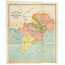
Indo-Chine Française Cochinchine. Régime des Eaux Réseaux.
Charming map of the southern third of current Vietnam whose principal city is Saigon or Prey Nokor in Khmer. It was a French colony from 1862 to 1954.Prepared by R.Brissa...
- $150 / ≈ €131
Date: Saigon, Librairie Brunet. c.1920
Indo-Chine Française Cochinchine. Carte historique Anciennes Provinces.
Charming map of the southern third of current Vietnam whose principal city is Saigon or Prey Nokor in Khmer. It was a French colony from 1862 to 1954.Prepared by R.Brissa...
- $150 / ≈ €131
Date: Saigon, Librairie Brunet. c.1920
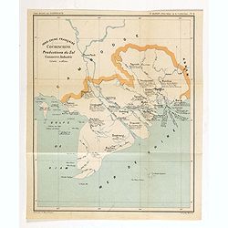
Indo-Chine Française Cochinchine. Productions du Sol Commerce, Industrie.
Charming map of the southern third of current Vietnam whose principal city is Saigon or Prey Nokor in Khmer. It was a French colony from 1862 to 1954.Prepared by R.Brissa...
- $150 / ≈ €131
Date: Saigon, Librairie Brunet. c.1920
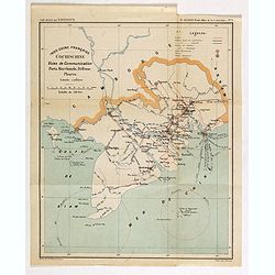
Indo-Chine Française Cochinchine. Voies de Communication Ports Marchants, Défense Phares.
Charming map of the southern third of current Vietnam whose principal city is Saigon or Prey Nokor in Khmer. It was a French colony from 1862 to 1954.Prepared by R.Brissa...
- $150 / ≈ €131
Date: Saigon, Librairie Brunet. c.1920
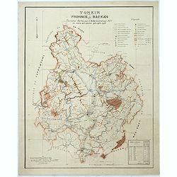
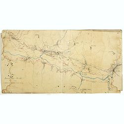
Tonkin Province de Bac-Kan Tournées faites par l'administrateur Blu au cours des années 1921-1922-1923.
Large scale manuscript map (1:200,000) centered on B?c K?n province in the northern region of Vietnam, north of the capital Hanoi.With a key in upper right corner, to the...
- $3000 / ≈ €2621
Date: Hanoï, 1924
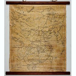
Railway map of China.
Railway map of China. Key in the left with keys to capital cities, Ocean cables, etc. Published by The Chinese Government Bureau of Economic Information, which was a nonp...
- $350 / ≈ €306
Date: China, ca. 1928
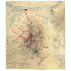
Carte du massif montagneux de Kuling (Province de Kiand-Si).
Manuscript map of the Kuling mountain range, showing the YangTze River, Lake Poyang, villages, etc. in French. Signed J.Volaz (?).Guling (or Kuling), is a resort town in ...
- $1500 / ≈ €1310
Date: China ?, ca.1930

Art Deco gouache with Japanese scene.
Lovely art-deco gouache by Lucien Baubaut of an elaborately robed Japanese woman. The colors are simply stunning jewel-toned emerald, violet, deep purple, saffron and tan...
Date: Paris, ca. 1930
l'Indochine Française
Map of Indochina published ca 1937 by Fernand Nathan, a well-known publisher of school books, maps and material for teaching geography.
Date: Paris, ca. 1937
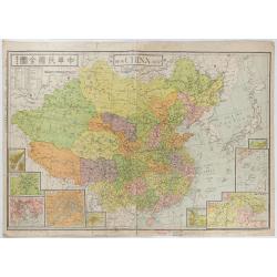
New China Map.
Very large and detailed map of China (1:6,000,000) printed in Shanghai, June 27th 1938 by JIN-SHIN GEOGRAPHICAL INSTITUTE.The title and place names in Chinese and Engli...
- $900 / ≈ €786
Date: Shanghai, June 27th 1938
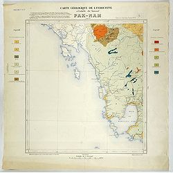
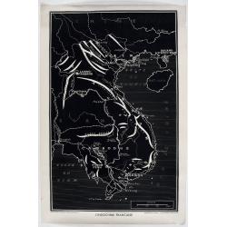
Carte géologique de l'Indochine à l'échelle du 1/500 000e. Pak-Nam Bang-Kok.
Map of Indochina Sheet N ° 16. Covers the area from Paknam (Thailand) to Kompong-Som Bay (Cambodia). On both sides a legend indicates the sedimentary and crystalline lan...
- $130 / ≈ €114
Date: Indo Chine, 1939
![Daily Telegraph War Map of The Far East. [No.11]](/uploads/cache/42244-250x250.jpg)
Daily Telegraph War Map of The Far East. [No.11]
A large and very detailed map of The Far East "Specially drawn for the Daily Telegraph by 'Geographia' Ltd". Printed in full color. Map extends from the norther...
- $125 / ≈ €109
Date: London, ca. 1940
![Singapura em poder das Japoneses. [Singapore in Japanese Power]](/uploads/cache/48732-250x250.jpg)
Singapura em poder das Japoneses. [Singapore in Japanese Power]
An uncommon large Portuguese language and produced broadside celebrating the Japanese invasion of Singapore during WWII. It was published on behalf of the German Army Hig...
- $750 / ≈ €655
Date: Portugal, ca 1942
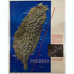
Formosa.
A large poster size map of the island of Formosa (Taiwan) off the Chinese mainland, prepared as a News Maps special edition during WWII. There is a red diagonal measureme...
- $750 / ≈ €655
Date: New York, 1943
![[Escape map] N°34 Southeast Asia + Northeast Asia.](/uploads/cache/40293-250x250.jpg)
[Escape map] N°34 Southeast Asia + Northeast Asia.
A fine "survival map" or "escape map" of China was compiled for the U.S. Army Air Forces. South China side has an inset of Taiwan (Formosa). These lig...
- $125 / ≈ €109
Date: Washington, D.C. 1944

China Southeast Coast.
A very large US Army and Naval map of the south east coast of China, published during the second world war. Map extent is from Kweichow Province in the west, to Kwangsi P...
- $1250 / ≈ €1092
Date: [New York], 1944
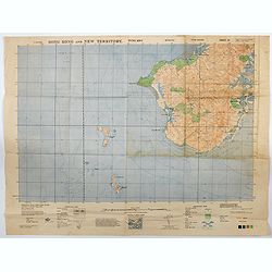
Hong Kong and New Territory - Tung Kwu.
A third edition air survey map of this portion of Lantau Island, to the west of Hong Kong, performed by the RAF. Originally published in 1931, then with minor corrections...
- $300 / ≈ €262
Date: London, 1945
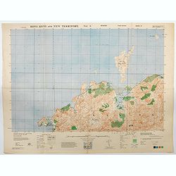
Hong Kong and New Territory - Tai O.
A third edition air survey map of this mainland portion of north west Hong Kong and New Territory, performed by the RAF. Originally published in 1931, then with minor cor...
- $400 / ≈ €349
Date: London, 1945
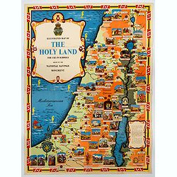
Ilustrated Map of The Holy Land for use in schools…
A visually striking and impressive pictorial map of The Holy Land, as issued by the National Savings Movement / Committee during the 1950s. In the upper left quadrant of...
- $250 / ≈ €218
Date: London, ca. 1950
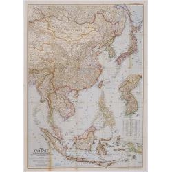
The Far East Compiled and Drawn in the Cartographic Section of the National Geographic Society for the National Geographic Magazine Gilbert Grosvenor. . .
Map of Far East Asia, with inset map of Korea. Scale 1:7.500.000. The first issue of National Geographic Magazine was published on September 22, 1888, nine months after t...
- $75 / ≈ €66
Date: Washington, 1952
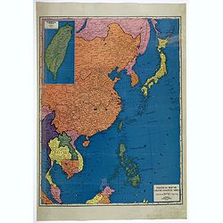
Political Map of Asiatic Coastal Area.
A strongly colored, large map of the Asiatic Coastal countries. All countries are color coded. Maps coverage is from China and Japan in the north, south to the tips of Su...
- $450 / ≈ €393
Date: Chicago, ca 1952
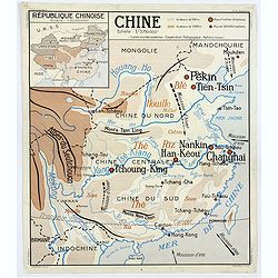
Chine - Angleterre.
A large, vintage French school poster map from the 1950s, showing China on one side and the United Kingdom on the reverse. As you would expect content and detail and basi...
Date: Nalliers, ca 1955
China sea. Tong King Gulf Compiled from the latest British and Foreign Government surveys to 1886. . .
Detailed Map of Chart of Annam Gulf or Tong King Gulf, in the China Sea. Chart with legend and scale. British Admiralty chart No. 2062, published June 1881, large correct...
- $400 / ≈ €349
Date: London, 1881 updated to 1957

Festivals of India.
A large eye-catching poster of five women, dancing against a black background, dressed in stunning sari's of red, yellow and blue, produced in India by the Government, wi...
- $750 / ≈ €655
Date: Calcutta, 1959

Balinees watercolor on paper, fisherman.
Decorative export painting from Bali of a more than average quality.
- $150 / ≈ €131
Date: Bali, ca 1960

Balinees watercolor on paper, fishermen.
Decorative export painting from Bali of a more than average quality.
Date: Bali, ca 1960

Balinees watercolor on paper, fishermen.
Decorative export painting from Bali of a more than average quality.
- $150 / ≈ €131
Date: Bali, ca 1960
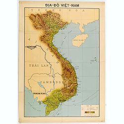
Dia-Do Viet-Nam.
Economic map of Vietnam published in 1960 (not for sale), gift from Japan paper committee. Scale : 1:2 400 000. With a key at lower right part.Features Vietnam, Cambodia,...
Date: 1960
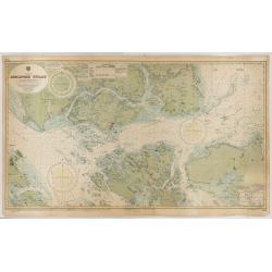
China Sea - Singapore Strait principally from British Admirality
An exceptionally nautical British Admiralty nautical chart of Singapore and direct vicinity. Centered Singapore city and the narrow strait between Singapore Island and Pu...
Date: Admirality, London, [1865-1960] updated 1960
![[US Army map of a part of Vietnam.]](/uploads/cache/44790-250x250.jpg)
[US Army map of a part of Vietnam.]
A large aerial US Army map of a portion of Vietnam, taken during the war between the two countries. As you might expect the map is highly detailed, highlighting settlemen...
- $150 / ≈ €131
Date: Washington D.C., 1967
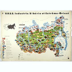
U.R.S.S. Industrie. Sibérie et Extreme-Orient. (4)
Map of Siberia. Propaganda poster for Russia's in and export of industrial goods from Siberia. Editions de l'Agence de presse Novosti".More about War Maps & Prop...
- $150 / ≈ €131
Date: USSR, 1978
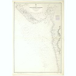
India west coast Gulf of Cutch to Vijaydurg . . .
Chart of India's west coast map surveyed by the hydrographer Captain JF Parry. A highly corrected version of Admiralty chart 2736 originally published 1st July 1915. Date...
- $200 / ≈ €175
Date: London, 1915-1980

Anamu Buru to Latakia including Iskenderun Körfezi.
A highly corrected version of Admiralty chart 2632 originally published 25 November 1955 under the Superintendence of Captain K.SB. Collins. Edition Date 1984 Detailed ch...
- $100 / ≈ €87
Date: London, 1955 - 1984
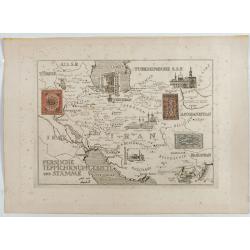
Persische Teppichknüpfgebiete und Stämme.
Map of Iran and neighboring countries in German language, published in limited edition probably in France : "Gravée à l'eau-forte et au burin. Edition limitée&quo...
Date: France ?, after 1935 - before 1991
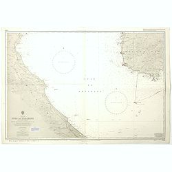
China Sea Luzon Strait between Luzon and Tai-Wan from the United States & Japanese Government chartsto 1929. . . (3804)
A highly corrected version of Admiralty chart 3804 originally published 18 September 1925 under the Superintendence of Captain P.H. Douglas. New Editions 18th December 19...
- $150 / ≈ €131
Date: London, 1929 / 1992
China sea Gulf of Tongking (Southern sheet).
A highly corrected version of Admiralty chart 3989 originally published 11 Mai 1962 under the Superintendence of Captain EG Irving. Detailed chart including the coasts of...
- $80 / ≈ €70
Date: London, 1962 - 1992
China Sea Philippine Islands - San Bernandino Strait and approaches. (3370)
A highly corrected version of Admiralty chart 3370 originally published 14th November 1924 under the Superintendence of Captain H.P. Douglas. Edition Date 1982 with furth...
- $150 / ≈ €131
Date: London, 1924 / 1996

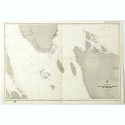
Philippine Islands - Semirara, Ilin and Ambulong 1.s with part of Mindoro. (971)
A highly corrected version of Admiralty chart 971 originally published 15th February 1866 under the Superintendence of Captain G.H. Richards. Edition Date 1991 with furth...
- $150 / ≈ €131
Date: London, 1866 / 1999

Philippine Islands - Mindanao West Coast - Basilan Strait to Camiguin Island including Tubbataha Reefs. . . (3811)
A highly corrected version of this oversized Admiralty chart 3811 originally published 26th February 1925 under the Superintendence of Captain P.H. Douglas. Edition Date ...
- $150 / ≈ €131
Date: London, 1925 / 2005
