Browse Listings in Asia
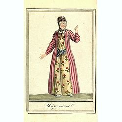
Kirguisienne.
Originally hand-colored mezzotint from 'Costumes civils actuels de tous les peuples connus', showing a native of Kyrgyzstan, a Central Asian country along the Silk Road, ...
- $25 / ≈ €22
Date: Paris,1801-1806
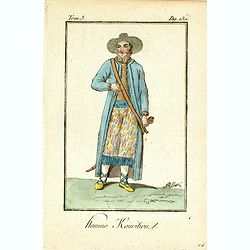
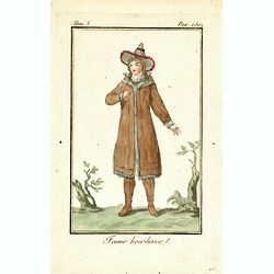
Homme Kouritien.
Originally hand-colored mezzotint of Siberian man dressed in native garb engraved by Félix Mixelle and Lachaussée Jeune after Jacques Grasset de Saint-Sauveur.As an etc...
- $25 / ≈ €22
Date: Paris,1801-1806
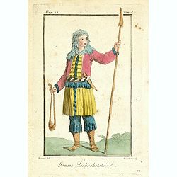
Homme Tschoukotske.
Originally hand-colored mezzotint of a man from Tschukotka, Syberia engraved by Félix Mixelle and Lachaussée Jeune after Jacques Grasset de Saint-Sauveur.As an etcher, ...
- $25 / ≈ €22
Date: Paris,1801-1806
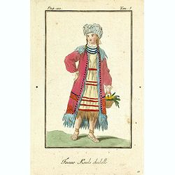
Femme Kamls chadalle.
Originally hand-colored mezzotint of native woman from Kams, Siberia, Russland engraved by Félix Mixelle and Lachaussée Jeune after Jacques Grasset de Saint-Sauveur.As ...
- $50 / ≈ €44
Date: Paris,1801-1806
Femme Kourilienne.
Originally hand-colored mezzotint of a native Kourilles lady engraved by Félix Mixelle and Lachaussée Jeune after Jacques Grasset de Saint-Sauveur. From 'Costumes civil...
- $25 / ≈ €22
Date: Paris,1801-1806
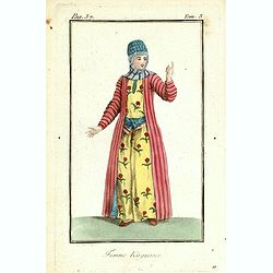
Femme Kirguisses.
Originally hand-colored mezzotint of Native Tartary lady engraved by Félix Mixelle and Lachaussée Jeune after Jacques Grasset de Saint-Sauveur. From 'Costumes civils ac...
- $25 / ≈ €22
Date: Paris,1801-1806
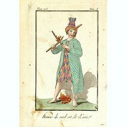
Homme du nord est de l'Asie.
Originally hand-colored mezzotint of a native from North Eastern Russia engraved by Félix Mixelle and Lachaussée Jeune after Jacques Grasset de Saint-Sauveur. From 'Cos...
- $50 / ≈ €44
Date: Paris,1801-1806
Charte von Ostindien disseits des Ganges im gegenwärtigen Zustande.
A uncommon issue of this detailed map of India, including Ceylon.
Date: Weimar, 1807
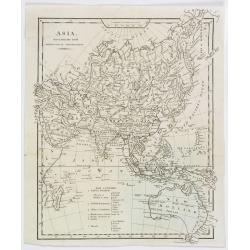
Asia, drawn from the latest Astronomical Observations.
This finely engraved, and detailed, map of Asia shows the extent of knowledge from astronomical observations at the time. It is also of interest for showing Australia her...
Date: London ca. 1808
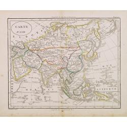
Carte d'Asie.
Fine map of Asia, with an interesting representations of Japan, Hokkaido, Sakhalin Island, Kamchatka and Korea. Engraved by Alexandre Blondeau, who also worked for Depot ...
- $150 / ≈ €131
Date: Paris, c. 1810
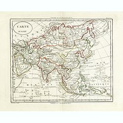
Carte d'Asie.
Fine map of Asia, with an interesting representations of Japan, Hokkaido, Sakhalin Island, Kamchatka and Korea. Engraved by Alexandre Blondeau, who also worked for Depôt...
Date: Paris, c. 1810
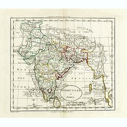
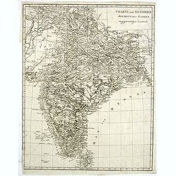
Indoustan ou Inde.
Map of India. The map is based on the Paris Meridian, only in 1884, at the International Meridian Conference in Washington DC, the Greenwich Meridian was accepted.Engrave...
- $100 / ≈ €87
Date: Paris, c. 1810
Carte d'Asie.
Fine map of Asia, with an interesting representation of Japan, Hokkaido, Sakhalin Island, Kamchatka, and Korea. Engraved by Alexandre Blondeau, who also worked for Depôt...
- $175 / ≈ €153
Date: Paris, c. 1810
Carte d'Asie.
Fine map of Asia, with an interesting representations of Japan, Hokkaido, Sakhalin Island, Kamchatka and Korea. Engraved by Alexandre Blondeau, who also worked for Depôt...
- $150 / ≈ €131
Date: Paris, c. 1810
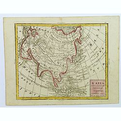
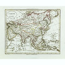
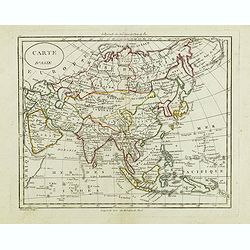
L'Asia...
A small, uncomplicated map of Asia with outline coloring. Map extends down from the Arctic Circle to Java and New Guinea. From Arabia in the west to Japan in the east.Sma...
- $175 / ≈ €153
Date: Venezia, 1810
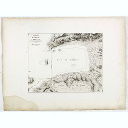
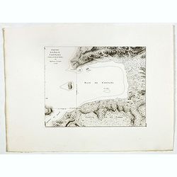
Esquisse de la Baie de Coupang (cote S.O. Ile de Timor) par M. M. Peron et Lesueur, an 1803.
Map of Kupang Bay on the Indonesian Island Timor, prepared by Louis Freycinet during his voyage under Captain Thomas Baudin in 1800-1803. Plate no. 14 from the atlas part...
- $100 / ≈ €87
Date: Paris, Langois, 1811
Esquisse de la Baie de Coupang (cote S.O. Ile de Timor) par M. M. Peron et Lesueur, an 1803.
Map of Kupang Bay on the Indonesian Island Timor, prepared by Louis Freycinet during his voyage under Captain Thomas Baudin in 1800-1803. Plate no. 14 from the atlas part...
- $150 / ≈ €131
Date: Paris, Langois, 1811
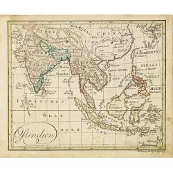
Ostindien.
Nice small map of South East Asia published by Johannes Walch in his rare Allgemeiner Atlas Nach den bewährsten Hülfsmitteln und astronomischen Ortsbestimungen…, edit...
- $160 / ≈ €140
Date: Augsburg, 1812
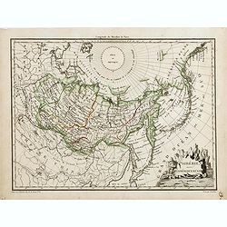
Sibérie avec l'Amérique Russe.
Prepared by Pierre Lapie and published by François Buisson and included in "Atlas Complet Du Precis De La Geographie Universelle De M. Malte-Brun". Engraved by...
- $120 / ≈ €105
Date: Paris, 1812
![[assorted Chinese musical instruments].](/uploads/cache/37968-250x250.jpg)
[assorted Chinese musical instruments].
A delightful copperplate print of 15 assorted Chinese musical instruments including gong, bell, drum, cymbals etc.
- $35 / ≈ €31
Date: Germany, ca. 1812
![[assorted Chinese musical instruments].](/uploads/cache/37969-250x250.jpg)
[assorted Chinese musical instruments].
A delightful copperplate print of 15 assorted Chinese musical instruments including violin, flute, trumpet, guitars, cymbals etc.
- $30 / ≈ €26
Date: Germany, ca. 1812
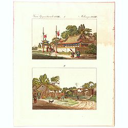
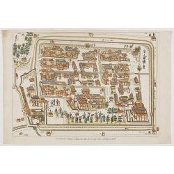
Verm Gegenstaende. CXIII. 1 Melandes CCXIII.
A Chinese Mandarin house and below a Chinese village scene with farmers.
- $50 / ≈ €44
Date: Germany, 1812
![Ansicht von Megasaky. [Nagasaki - title also in Russian characters]](/uploads/cache/24829-250x250.jpg)
Ansicht von Megasaky. [Nagasaki - title also in Russian characters]
The print shows Nagasaki harbor with n the foreground the Russian delegation with Krusenstern in a boat with 3 Chinese. Japanese junks and the town of Nagasaki in the ba...
- $1500 / ≈ €1310
Date: St.Petersburg, 1810-1814
![Ansicht der stadt Nangasaky. [Nagasaki - title also in Russian characters]](/uploads/cache/24839-250x250.jpg)
Ansicht der stadt Nangasaky. [Nagasaki - title also in Russian characters]
A lively scene in Nagasaki harbor. In the foreground, Japanese junks and the town of Nagasaki in the background, with the warehouses on Deshima, the trading post of the D...
- $3000 / ≈ €2621
Date: St.Petersburg, 1810-1814
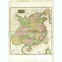
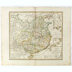
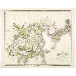
China.
Highly detailed map of China including Formosa (Taiwan), Hainan, and part of Luzon in the Philippines. The map show the Tract of the Hindoostan and Lion with the British ...
Date: Edinburgh, 1815
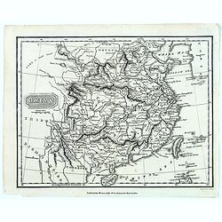
China.
From the atlas the 'Universal Geography' by Thos. Kelly, and engraved by Finlay. This copper plate maps shows the mainland of China, together with the islands of Formosa ...
Date: London, ca. 1817
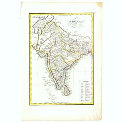
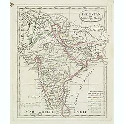
El Indostan por D. Juan Lopez.
Uncommon map of India and Shri Lanka published by Juan Lopez (1765-1830) and included in his "Atlas Universal o collection de mapas nuevos. . ." first published...
Date: Madrid, 1817
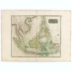
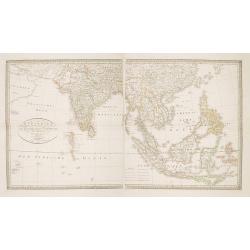
East India Isles.
Somewhat later but very finely engraved and detailed map of the Indonesian archipelago, including Thailand, Philippines and southern part of Taiwan.
Date: Edinburgh, 1817
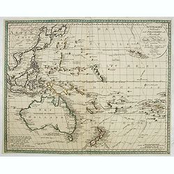
Australien (Südland) auch Polynesien oder Inselwelt..
SECOND EDITION of the Johann Walch map of Australasia and the South Pacific. Australia lettered Neu Holland, the name given to it by Able Tasman that was still in use un...
Date: Augsburg, 1802-1820
La factorerie chinoise a nagasaki, dans la rue Teng-chan (fondée en 1688).
The Chinese traders at Nagasaki were confined to a walled compound which was located in the same vicinity as Dejima island; and the activities of the Chinese, though less...
- $500 / ≈ €437
Date: Paris, A. Nepveu, 1820
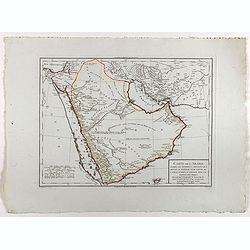
Carte de l'Arabie d'après les différents morceaux qu'a donnés M. Niebuh...
Detailed map of the Arabian peninsular, after Niebuhr, with scales in lower left corner. Engraved by Pierre-Paul Dubuisson.More about Mapping of Arabia [+]
Date: Paris, ca. 1820
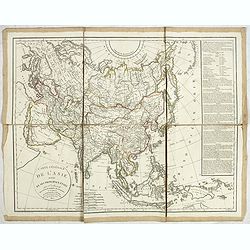
Carte générale de L'asie . . .
Uncommon map of Asia prepared by Felix Delamarche, after R.de Vaugondy. In the right hand a lengthy description of geographical details of the different European countrie...
Date: Paris, 1820
Charte von China nach Murdochischer Projection entworfen. ... Berichtiget, und gezeichnet von H.F.A. Stieler. . .
Uncommon map of China prepared by H.F.A.Stieler, with parts of Taiwan, Tibet, Mongolia and the Korean peninsula, with a great many place names, a key to (and brief explan...
Date: Augsburg, 1820
Karte der Hauptstraßen von der niederen Donau bis Constantinopel … / Spezialkarte des Meerbusens von Burgas . ..
Uncommon map of the routes of the eastern part of the Balkan Peninsula. prepared by C. Zirbeck The map has two insets "Meerbusen von Burgas oder Mesambri" (Bay ...
- $550 / ≈ €480
Date: 1820
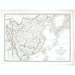
Carte de la Chine et du Japon. Dressée pour l'intelligence de l'histoire général des voyages de Laharpe. . .
Engraved by Tardieu for L'Intelligence de l'histoire generale des Voyages de Laharpe .Rare and detailed map of China, Korea, Japan and Taiwan (I.Formose ou Pekan).
Date: Paris, 1821
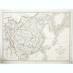
Carte de la Chine et du Japon..
Engraved by Tardieu for L'Intelligence de l'histoire generale des Voyages de Laharpe .Rare and detailed map of China, Korea, Japan and Taiwan (I.Formose ou Pekan).
- $100 / ≈ €87
Date: Paris, 1821
Charte von Ostindien Diesseits Und Jenseits Des Ganges / nach den neuesten astronomischen Beobachtungen auch andern sichern Hülfsmitteln neu entworfen. . .
Prepared by I.C.M.Reinecke giving good detail in India, Indonesia and the Philippines.
- $800 / ≈ €699
Date: Weimar, 1822
Indostan gia impero del mogol. . .
Charming map of India with Ceylon from the rare atlas Atlante Tascabile o sia Serie di Num. XXI Cartine Geografiche nelle quali si rappresenta in ristretto lo Stato Attua...
- $150 / ≈ €131
Date: Rome, 1823

Eastern passage to China. sheet 1.
James Horsburgh early chart of the coasts of Java, Bali, Lombok, with part of Sulawesi, and Borneo. Insets of "Sketch of Bally Strait", Sketch of Lombock Strait...
- $2500 / ≈ €2184
Date: London, 1824
Timor - Malais libre.
A fine color plate from the rare travel book: Voyage de découvertes aux terres Australes . The Baudin voyage from 1800-1804 was the most successful French scientific exp...
- $100 / ≈ €87
Date: Paris, Langlois, 1824
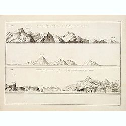
Ansicht der Küste von Kamtschatka vom Cap Poworotnoy Nordlich hinauf - Ansicht der Einfahrt in die Awatscha Bay, in einer entfernung von 4 meilen.
An original view in imperial folio size, originating from the original first edition (Russian & German) of Krusenstern's atlas to his voyage around the world: Atlas k...
- $1000 / ≈ €874
Date: St.Petersburg, 1824
China and Japan drawn and engraved for Dr. Playfairs Atlas.
Detailed map of China, Korea, Japan and Taiwan engraved by H. Cooper and published by Alexander Macredie. Originally engraved for James Playfair's " A New General At...
- $700 / ≈ €611
Date: Edinburgh, 1824
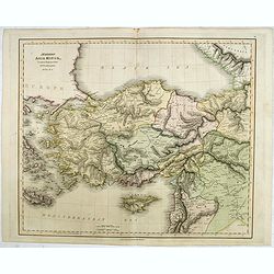
Modern Asia Minor. Drawn & Engraved for Dr. Playfair's Geography.
Detailed map of Black Sea, Cyprus and Turkey engraved by Samuel John Neele (1758-1824) and published by Alexander Macredie. Originally engraved for James Playfair's "...
- $175 / ≈ €153
Date: London / Edinburgh, 1824
![Timor. Naba-Leba, Roi de L'Ile Solor. [plate XXV]](/uploads/cache/40114-250x250.jpg)
Timor. Naba-Leba, Roi de L'Ile Solor. [plate XXV]
Nicely colored portrait of the King of Solor, or Timor in South East Asia.After the original sketches by Lesueur, from Voyage de découvertes aux terres Australes by Fran...
- $100 / ≈ €87
Date: Paris, 1824
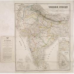
Vonder Indien.
Map of India with two inset maps, one of Upper Asam, and the other of Ceyland.
Date: Weimar, 1822-1825
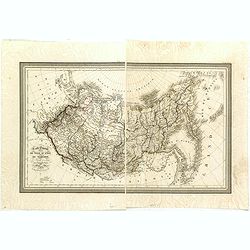
Carte Generale de la Russie d'Asie ou Siberie. Par L. Vivien, Geographe . . .
First edition, with a second edition in 1834 listed by Phillips. The map is well done, slightly smaller than the contemporary Brue and Lapie maps. Showing Asian part of R...
- $230 / ≈ €201
Date: Paris, Ménard et Desenne, 1825
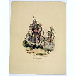
Garde Imperiale. Cavalier et Fantassin.
A decorative, colored lithograph of a Guard in the Chinese Imperial Army, and that of a Cavalier. From the work by Malpiere titled: " La Chine, Moeurs, Usages, Arts ...
- $50 / ≈ €44
Date: Paris, ca. 1825
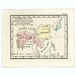
Missions en Asie Contenant les Provinces Françaises de la Chine et des Indes avec le Malabar Province des Portuguais. 7 Jésuits a la Chine et 57 au Japon.
Rare map of Far East from India until Japan from "Atlas Universel indiquant les établissemens des Jésuites: avec la manière dont ils divisent la terre, suivi des�...
- $200 / ≈ €175
Date: Paris, Ambroise Dupont , 1826
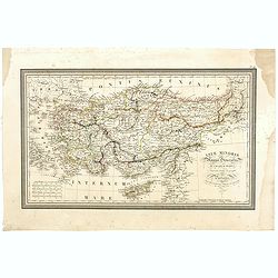
Asiae Minoris Stappa generalis ad Caesarum tempus.
A lovely steel engraved map of Turkey, Cyprus and Minor Asia. From Louis de Saint-Martin Vivien's Atlas Universel. Engraved by Giraldon-Bovinet.
Date: Paris, 1826
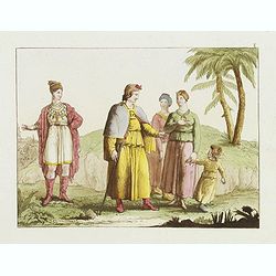
![[Family from Kyrgyz Republic - Costumes des Kirguises]](/uploads/cache/24477-250x250.jpg)
[Family from Kyrgyz Republic - Costumes des Kirguises]
Aquatint engraved by D.K. Bonatti, after drawings by C. Bottigella. Showing a family in typical dress from the Kyrgyz Republic. Man is holding a bird.In the late nineteen...
- $70 / ≈ €61
Date: Milan, 1827
![[Taoism religion of the Callmoucks].](/uploads/cache/25834-250x250.jpg)
[Taoism religion of the Callmoucks].
Aquatint depicting six Taoist deities engraved by D.K. Bonatti, after drawings by C. Bottigella. Plate N° 43. The Tatars people which live almost all in the north of Asi...
- $45 / ≈ €39
Date: Milan, 1827
![[ Tartars ].](/uploads/cache/25836-250x250.jpg)
[ Tartars ].
Aquatint depicts a group of Taguri Tartars of the Crimea in traditional attire, engraved by D.K. Bonatti, after drawings by G.Gattina. Plate N° 45 From Giulio Ferrari...
- $45 / ≈ €39
Date: Milan, 1827
![[Sumatra plants ].](/uploads/cache/25837-250x250.jpg)
[Sumatra plants ].
Aquatint depicting coffee, pepper et other plants in Sumatra. Plate N° 46.From Giulio Ferrario's work Le Costume Ancien et Moderne ou Histoire du gouvernement, de la mil...
- $50 / ≈ €44
Date: Milan, 1827
![[No title]. [Two locals of the island of Ubi ].](/uploads/cache/25845-250x250.jpg)
[No title]. [Two locals of the island of Ubi ].
Aquatint depicting two locals, one rowing to shore, the other searching for sea shells on the Island of Ubi in the Moluccas. Engraved by Carlo Bottigella. From Giulio Fer...
- $40 / ≈ €35
Date: Milan, 1827
![[ Island of Bouro with a view of Cayeli ].](/uploads/cache/25846-250x250.jpg)
[ Island of Bouro with a view of Cayeli ].
Aquatint depicts a view of Cayeli on the island of Bouro. Engraved by G.Castellini. Plate N° 55.From Giulio Ferrario's work Le Costume Ancien et Moderne ou Histoire du g...
- $50 / ≈ €44
Date: Milan, 1827
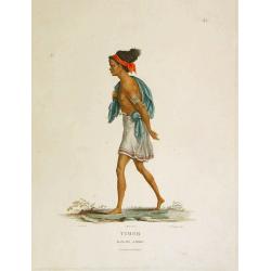
![[ A man and woman from Timor ].](/uploads/cache/25847-250x250.jpg)
[ A man and woman from Timor ].
Aquatint depicting a man and woman from Timor, engraved by A.Biasioli. Plate N° 56. The weaving of traditional scarves or tais is widespread in East Timor. From Giulio...
- $50 / ≈ €44
Date: Milan, 1827
![[Mongolian pipe smoking ].](/uploads/cache/26258-250x250.jpg)
[Mongolian pipe smoking ].
Aquatint depicting a group of Mongolians in traditional attire during a pipe smoking ceremony. Chinese and Mongolian tradition had tobacco smoking from pipes with small m...
- $80 / ≈ €70
Date: Milan, 1827
![[Fauna and flora - Siberia].](/uploads/cache/25815-250x250.jpg)
[Fauna and flora - Siberia].
Aquatint depicting a donkey, a weasel and a squirrel, and three botanical plants in Siberia engraved by C.A.Raineri, after drawings by C. Bottigella. Plate N° 22.From Gi...
- $50 / ≈ €44
Date: Milan, 1827
![[Tartares Katschins ].](/uploads/cache/25818-250x250.jpg)
[Tartares Katschins ].
Aquatint depicting people from Tartary engraved by Cantelli, after drawings by C. Bottigella. Plate N° 26.From Giulio Ferrario's work Le Costume Ancien et Moderne ou His...
- $50 / ≈ €44
Date: Milan, 1827
![[Ostiaks ].](/uploads/cache/25822-250x250.jpg)
[Ostiaks ].
Aquatint depicting a Ostiaks people engraved by D.K. Bonatti, after drawings by C. Bottigella.The Ostiak people are a tribe who inhabit the basin of the Ob in western Sib...
- $50 / ≈ €44
Date: Milan, 1827
![[Samoyedes ].](/uploads/cache/25823-250x250.jpg)
[Samoyedes ].
Aquatint depicting Samoyedes warming up around a camp fire engraved by D.K. Bonatti, after drawings by C. Bottigella. The Samoyedes is a tribe of the Ural-Altaic group, s...
- $50 / ≈ €44
Date: Milan, 1827
![[Yakuts ].](/uploads/cache/25825-250x250.jpg)
[Yakuts ].
Aquatint depicting Yakuts in traditional dress engraved by D.K. Bonatti, after drawings by C. Bottigella.The Yakuts live in the Republic of Sakha (YakutiaYakutia), Khabar...
- $75 / ≈ €66
Date: Milan, 1827
![[Tibetan Gilong monk].](/uploads/cache/25835-250x250.jpg)
[Tibetan Gilong monk].
Aquatint depicting a Tibetan Gilong monk with persons from the City of Karakoran engraved by D.K. Bonatti, after drawings by C. Bottigella of a family of Turkestan. Plate...
- $100 / ≈ €87
Date: Milan, 1827
![[Costume plate of locals of Dourans tribe in Afganistan]](/uploads/cache/62330-250x250.jpg)
[Costume plate of locals of Dourans tribe in Afganistan]
Aquatint showing locals of Dourans tribe in Afghanistan in their typical dress. Plate N° 1. Engraved by C. Bottigella.From Giulio Ferrario's work Le Costume ancien et mo...
- $50 / ≈ €44
Date: Milan, 1827
![[Costume plate of locals of Afganistan]](/uploads/cache/62331-250x250.jpg)
[Costume plate of locals of Afganistan]
Aquatint showing locals of Afghanistan in their typical dress. Plate N° 2. Engraved by D.K.Bonatti.From Giulio Ferrario's work Le Costume ancien et moderne ou histoire d...
- $60 / ≈ €52
Date: Milan, 1827
![[Afganistans in their typical dress]](/uploads/cache/62332-250x250.jpg)
[Afganistans in their typical dress]
Aquatint showing local of Afghanistan in their typical dress. Plate N° 3.From Giulio Ferrario's work Le Costume ancien et moderne ou histoire du gouvernement, de la mili...
- $50 / ≈ €44
Date: Milan, 1827
![[Tassisoudon Palace - Palace Lama Chassatou]](/uploads/cache/62335-250x250.jpg)
[Tassisoudon Palace - Palace Lama Chassatou]
Two aquatint prints on one sheet show the Tassisoudon Palace and the Palace of Lama Chassatou in Tibet. Plate N° 6. From Giulio Ferrario's work Le Costume ancien et mode...
- $150 / ≈ €131
Date: Milan, 1827
![[View of Castle and Bridge Vandipore - Bhutan - Tibet ]](/uploads/cache/62336-250x250.jpg)
[View of Castle and Bridge Vandipore - Bhutan - Tibet ]
Aquatint print with a view of Castle and Bridge, Vandipore - Bhutan - Tibet. Plate N° 7. From Giulio Ferrario's work Le Costume ancien et moderne ou histoire du gouverne...
- $100 / ≈ €87
Date: Milan, 1827
[Gyap, father of the young Teschou Lama
Aquatint print with Gyap, father of the young Teschou Lama and his wife and the portrait of the Grand Lama. - Tibet. Plate N° 8. This is from Giulio Ferrario's work Le ...
- $80 / ≈ €70
Date: Milan, 1827
![[The procession of the regent of Tibet going to Teschou-Lumbou.]](/uploads/cache/62333-250x250.jpg)
[The procession of the regent of Tibet going to Teschou-Lumbou.]
Aquatint showing the procession of the regent of Tibet going to Teschou-Lumbou.. Plate N° 4.From Giulio Ferrario's work Le Costume ancien et moderne ou histoire du gouve...
- $100 / ≈ €87
Date: Milan, 1827
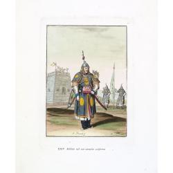
Soldato nel suo compito uniforme (Chinese soldier in full battle dress)
Aquatint with original coloring by Antonio Rancati, taken from Giulio Ferrario's work Le Costume ancien et moderne ou histoire du gouvernement, de la milice, de la religi...
- $80 / ≈ €70
Date: Milan, 1827
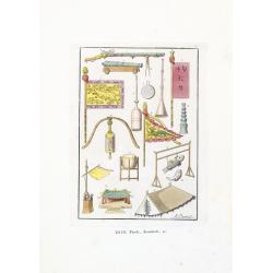
Tende, Stendardi (Chinese Military Equipment)
Aquatint with original coloring by Antonio Rancati, taken from Giulio Ferrario's work Le Costume ancien et moderne ou histoire du gouvernement, de la milice, de la religi...
- $80 / ≈ €70
Date: Milan, 1827
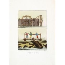
Macchine idrauliche. (Chinese hydraulic machines)
Aquatint with original coloring by G. Rossi, taken from Giulio Ferrario's work Le Costume ancien et moderne ou histoire du gouvernement, de la milice, de la religion, des...
- $50 / ≈ €44
Date: Milan, 1827
![[ LXXII. Divertimenti de' serpenti ].](/uploads/cache/34981-250x250.jpg)
[ LXXII. Divertimenti de' serpenti ].
Aquatint depicting snake charmers engraved by D.Klemi-Bonatti, Plate N°60.From Giulio Ferrario's work Le Costume Ancien et Moderne ou Histoire du gouvernement, de la mil...
- $50 / ≈ €44
Date: Milan, 1827
![[XXIII Infanteria ].](/uploads/cache/34982-250x250.jpg)
[XXIII Infanteria ].
Aquatint depicting Chinese infantry engraved by G Bigatti, Plate N°23.From Giulio Ferrario's work Le Costume Ancien et Moderne ou Histoire du gouvernement, de la milice,...
- $50 / ≈ €44
Date: Milan, 1827
![[XXV Cavalleria ].](/uploads/cache/34983-250x250.jpg)
[XXV Cavalleria ].
Aquatint depicting Chinese cavalry engraved by G Bigatti, Plate N°25.From Giulio Ferrario's work Le Costume Ancien et Moderne ou Histoire du gouvernement, de la milice, ...
- $50 / ≈ €44
Date: Milan, 1827
![[LVI. Strada di Nan-King].](/uploads/cache/34984-250x250.jpg)
[LVI. Strada di Nan-King].
Aquatint depicting a street in Nanking (Nanjing) engraved by G Zancon, Plate N°56.From Giulio Ferrario's work Le Costume Ancien et Moderne ou Histoire du gouvernement, d...
- $50 / ≈ €44
Date: Milan, 1827
![[LXXXI. Amida e Xaca ].](/uploads/cache/34985-250x250.jpg)
[LXXXI. Amida e Xaca ].
Aquatint depicting Amida (or Amideva who is a celestial Buddha) and the God Xaca, engraved by A.Rancati. Plate N°81.From Giulio Ferrario's work Le Costume Ancien et Mode...
- $40 / ≈ €35
Date: Milan, 1827
![[XIX. Principali persone componenti la marcia ec..].](/uploads/cache/34986-250x250.jpg)
[XIX. Principali persone componenti la marcia ec..].
Aquatint depicting a Chinese procession, engraved by G. Zacon, Plate N°16.From Giulio Ferrario's work Le Costume Ancien et Moderne ou Histoire du gouvernement, de la mil...
- $50 / ≈ €44
Date: Milan, 1827
![[LXXXIII. Nozze].](/uploads/cache/34987-250x250.jpg)
[LXXXIII. Nozze].
Aquatint depicting a Chinese wedding ceremony engraved by A. Rancati, Plate N°83.From Giulio Ferrario's work Le Costume Ancien et Moderne ou Histoire du gouvernement, de...
- $50 / ≈ €44
Date: Milan, 1827
