Browse Listings
Manuscript leaf on vellum from a Dutch Book of Hours.
RECTO: One 1-line capitals in red, blue or burnished gold with extensive penworkVERSO: One 1-line capitals in red, blue or burnished gold with extensive penwork.
- $250 / ≈ €218
Date: Flanders ca.1450
Leaf from a manuscript Psalter, written on vellum.
RECTO: 14 lines of text. One 2-line in burnished gold and colors and six 1-line initials in gold and colors, two line-fillers.VERSO: As recto but three 1-line initials an...
- $200 / ≈ €175
Date: Paris, c.1450
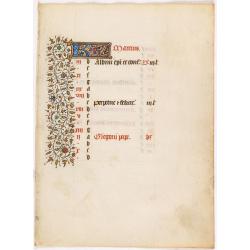
A manuscript leaf from a Book of Hours. (Calendar month of March)
RECTO : Calendar month of March with a 2-line initial in liquid gold on colored ground. colorful panel border in the left margin of acanthus leaves and flowers, with blac...
Date: Paris, ca. 1450
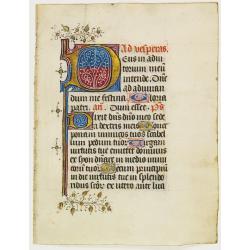
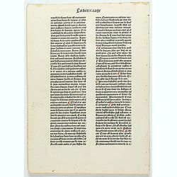
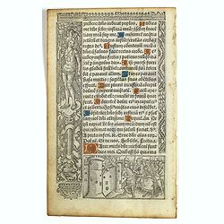
Handwritten leaf on vellum.
RECTO": justfication: 140 x 85 mm.16 lines of text in a good gothic bookhand, black ink.Large Initial "D"eus, 50 x 35 mm. 4 lines high in blue and purple w...
Date: Paris, 1450
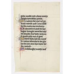
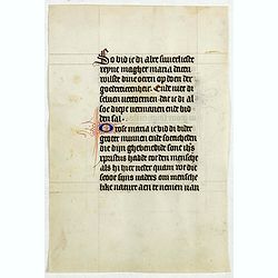
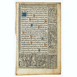
Manuscript leaf on vellum from a Dutch Book of Hours.
A leaf from a medieval manuscript Book of Hours, written in Utrecht.Fourteen lines of monastic Textura script with 4 one-line initials in liquid gold or blue ink with ext...
- $380 / ≈ €332
Date: Utrecht, ca.1450 - 1460
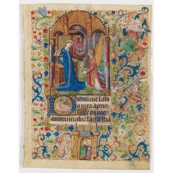
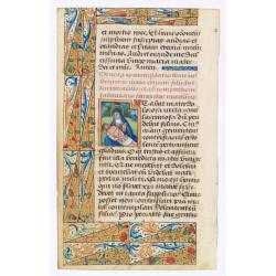
Miniature of Annunciation.
Page from a Book of Hours, use of Rome, with a large miniature set in full borders, by the Maitre François sub-group of Parisian artists of the middle of the second half...
Date: Paris ca. 1470
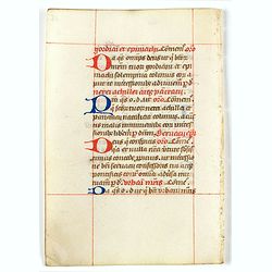
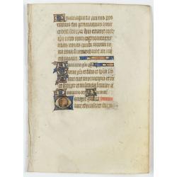
A leaf from a breviary.
Two large 2-line initials in red and or blue for the start of the new chapter.Nice clean leaves, with ample margins, from a breviary, end of the 15th. century.
- $100 / ≈ €87
Date: Northern Netherlands ?, ca. 1480
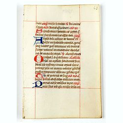
A leaf from a breviary.
Two large 2-line initials in red and or blue for the start of the new chapter.Nice clean leaves, with ample margins, from a breviary, end of the 15th. century.
- $100 / ≈ €87
Date: Northern Netherlands ?, ca. 1480
Leaf of vellum, with large miniature of Marry and Christ.
RECTO: Large miniature of Marry and Christ and one 1-line initials in burnished gold, on red ground and line-filler on blue ground. Three-sided illuminated borders of pen...
- $2200 / ≈ €1922
Date: France, c.1480
La tierce aage. Feuillet ix rr.
Incunable text pages from "La Mer des Hystoires" published in 1488 by Pierre Le Rouge in Paris. "La Mer des Hystoires" is a translation into French of...
- $50 / ≈ €44
Date: Paris, Pierre Le rouge, 1488
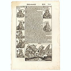
Quinta Etas Mudi. Folium. LXV (With view of Babylon)
The Latin text page is illustrated with an imaginary of the Ancient City of Babylon (Dim. H : 138 mm W : 223 mm).Babylon was the capital of Babylonia, the alluvial plain...
Date: Nuremberg, 12 July 1493
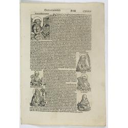
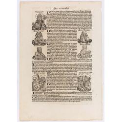
Sexta Etas Mundi. Folium. CXXXV
Latin text page with woodcuts on recto a large woodcut of Jerome (Hieronymus), a very pious and celebrated teacher, cardinal of the Roman church, and a priest, whose fath...
Date: Nuremberg, 12 July 1493
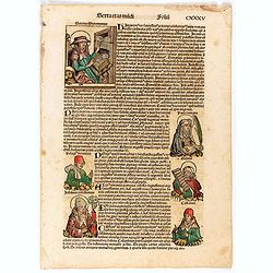
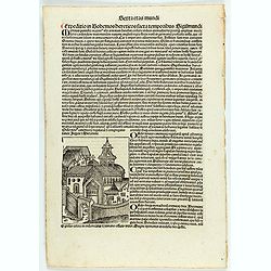
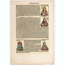
Terta Etas Mundi. Foliu CXXXV
The Latin text page is illustrated with depictions of Kings, Noble men and women and scientists. RECTO : Including a portrait of Jerome. Represented by a large woodcut, i...
- $100 / ≈ €87
Date: Nuremberg, 12 July 1493
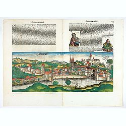
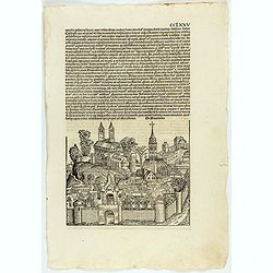
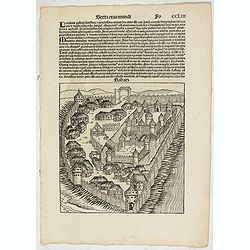
![[Text page with imaginary towns in Westphalia and Hesse. CCLXXXIIII ].](/uploads/cache/37487-250x250.jpg)
[Text page with imaginary towns in Westphalia and Hesse. CCLXXXIIII ].
On recto, an imaginary view of towns in Westphalia (230x225mm.). Verso of towns in the province Hesse.Page from the richest illustrated Incunabula, the famous: Nuremberg ...
- $200 / ≈ €175
Date: Nuremberg, 12 July 1493
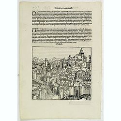
Quita Etas Mundi. Folium.LXXI (Toulouse)
The Latin text page is illustrated with an imaginary of Toulouse, France. VERSO are portraits of poets and teachers.Page from the richest illustrated Incunable, the famo...
Date: Nuremberg, 12 July 1493
Sexta Etas Mundi. Folium. CXXXII
Latin text page with woodcuts on recto and verso of Saints, Kings, and Queens. Page from the richest illustrated Incunable, the famous: Nuremberg Chronicle, published the...
Date: Nuremberg, 12 July 1493

Constantinopolis.
A spectacular woodcut panorama of the ancient city of Constantinople, proporting to show the pre-Turk city (for example naming St Sophia). (235x522mm).One of the earliest...
Date: Nuremberg, 12 July 1493
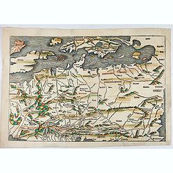
No title: Scandinavia/ Central Europe/ British Isles.
Map of Northern Europe from Nuremberg Chronicle . German text on verso. Printed by Anton Koberger. The map has been identified as the work of Hieronimus Münzer (1437-150...
Date: Nuremberg, 12 July 1493
![[Text page with Kings and Popes, folio CXLVIII ].](/uploads/cache/47603-250x250.jpg)
[Text page with Kings and Popes, folio CXLVIII ].
Text page with woodcuts of Kings and on verso woodcuts of Popes including Pope Gregorius. Page from the richest illustrated Incunable, the famous: Nuremberg Chronicle, p...
- $70 / ≈ €61
Date: Nuremberg, 12 July 1493
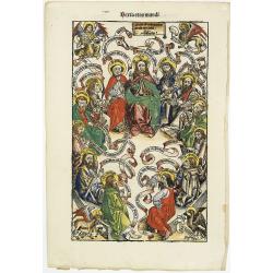
Sexta Etas Mudi. - Data est mihi potestas in celo et in terra: Salvator: CI. (Jesus Christ surrounded by the Twelve Apostles)
A very fine presentation of Jesus Christ surrounded by the Twelve Apostles. Each of the evangelists is represented by his symbol in the corners.Page from the richest illu...
Date: Nuremberg, 12 July 1493
![Parisius & Maguncia. [Paris & Munich] Folio XXXIX](/uploads/cache/29718-250x250.jpg)
Parisius & Maguncia. [Paris & Munich] Folio XXXIX
Imaginary view of Paris and on verso Munich : however the earliest obtainable views of this period.In the forground a large vessel, who was the symbol of the powerful cor...
Date: Nuremberg, 12 July 1493
![Sexta Etas Mundi. Bressla. [Breslau or Wrocław] CCXXXIIII.](/uploads/cache/33138-250x250.jpg)
Sexta Etas Mundi. Bressla. [Breslau or Wrocław] CCXXXIIII.
A very fine presentation of the city of Bresslau / Wrocław (230 x 520mm.), in Poland, centered on the cathedral (Dim. : 232 mm W : 520 mm).Overleaf, the kings Wenceslaw ...
Date: Nuremberg, 12 July 1493
PATAVIA (Passau, Germ)
From the first Latin text edition, 1493. The view of PATAVIA (nowadays the city of Passau, Southern Germany) was part of the Liber Chronicarum cum figuris et ymagibus ...
Date: Nuremberg, Germany, 1493
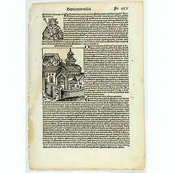
Sexta etas muidi Fo CCV.
The Latin text page is illustrating Baldwin (Baldvinus), the fourth of this name, seventh king of Jerusalem, and son of the aforesaid Amalric, reigned six years after his...
- $75 / ≈ €66
Date: Nuremberg, 12 July 1493
Tercia Etas Mundi. Foliu. XXVIII (with a view of the city of Lacedaemon or Sparta)
The Latin text page is illustrated with depictions of Kings, Noble men and women and scientists, including Atlas. RECTO : In the first panel, at the left, are some of the...
- $150 / ≈ €131
Date: Nuremberg, 12 July 1493
Sexta etas mudi CCXXXIX.
The Latin text page is describing the crusade against the Bohemian heretics in the time of emperor Sigismund Nuremberg Chronicle, published the year that Columbus returne...
Date: Nuremberg, 12 July 1493
Terta Etas Mundi. Folio CCXVI
Two pages from the richest illustrated Incurable, the famous: Nuremberg Chronicle , published the year that Columbus returned to Europe after discovering America.The wood...
- $100 / ≈ €87
Date: Nuremberg, 12 July 1493
CCLXXV.
The Latin text page is illustrated with an imaginary view of a town in Macedonia (195 x 225mm.) The Nuremberg Chronicle, published the year that Columbus returned to Euro...
Date: Nuremberg, 12 July 1493
Sexta Etas Mudi. (With view of Sabatz.) Folio CCLIII
A imaginary view of Sabatz, Turkey: however the earliest obtainable view of this period.Further including presentations of the popes Sixtus IV and Innocentius VIII. Pag...
- $200 / ≈ €175
Date: Nuremberg, 12 July 1493
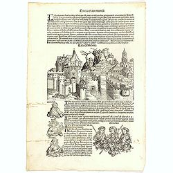
![Terta Etas Mundi. Foliu CX [With view of Metz]](/uploads/cache/46260-250x250.jpg)
Terta Etas Mundi. Foliu CX [With view of Metz]
The Latin text page is illustrated with a depictions of Kings, Noble men and women and scientists, among Eustace (Eustachius) a Roman soldier and martyr, appears as a bea...
- $450 / ≈ €393
Date: Nuremberg, 12 July 1493
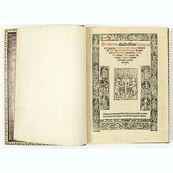
Strabonis illustrissimi scriptoris Geographia decem et septem libros continens.
First edition was published in Paris in the sixteenth century and the first with the preface by Thibaud Pigenat. Translation from Greek into Latin by Gregorio Tifernate a...
- $5000 / ≈ €4368
Date: Paris, Hémon Le Fèvre, 1512
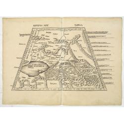
Septima Asie Tabula (Central Asia.)
A woodblock-printed large-format Ptolemaic map showing the region east of the Caspian Sea is labeled SOGDIANA. Sogdia or Sogdiana was an ancient Iranian civilization betw...
Date: Strasburg, 1513
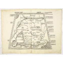
Secunda Asiae Tabula (Ukraine and Russia)
Woodblock printed a large-format Ptolemaic map showing Russia, Ukraine, and the Black Sea region. From the 1513 edition of Waldseemüller's Geographia.One of the earliest...
Date: Strasburg, 1513
![Septima Asie Tabvla. |Walsseemüller's map of Central Asia and the Silk Road]](/uploads/cache/62137-250x250.jpg)
Septima Asie Tabvla. |Walsseemüller's map of Central Asia and the Silk Road]
Trapezoidal woodcut map showing the area east of the Sarygamysh Lake, about midway between the Caspian Sea and the (former) Aral Sea. It is one of the earliest obtainabl...
Date: Strasburg, J. Schott, 1513
Leaf on vellum from a manuscript Book of Hours.
RECTO: One 2-line initials in liquid gold on colored grounds.VERSO: 17 lines of text in Latin.
- $150 / ≈ €131
Date: France, 1500-1520
![Tabula III Asiae. [Caucasus and Armenia.]](/uploads/cache/47571-250x250.jpg)
Tabula III Asiae. [Caucasus and Armenia.]
Ptolemaic map of the region south of the Caucasus Mountains and between the Caspian Sea as far south as the headwaters of the Tigris River in the south and the Black Sea,...
- $750 / ≈ €655
Date: Lyons, M. Servetus, 1525
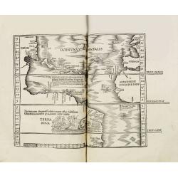
Claudii Ptolemaei geographicae enarrationis libri octo Bilibaldo Pirckeym hero interprete Annotationes Ioannis de Regio Monte in errores commissos a Iacobo Angelo in translatione sua.
This is a rare and interesting edition of Ptolemy's geography translated by Bilibaldo Pirckheym, accompanied by Regiomantus's annotations, and said to have been edited by...
- $59000 / ≈ €51540
Date: Strassburg, Johann Grüninger, Johann Koberger, 1525
Tabula X. Asiae hae sunt e cognitis totius orbis.
This is the earliest printed representation of India west of the Ganges River in Ptolemy's time. It is an essential map of southwestern Asia, including Persia, Afghanista...
Date: Lyons, M. Servetus, 1525
![Tabula IIII Aphricae. [with Prester John]](/uploads/cache/42945-250x250.jpg)
Tabula IIII Aphricae. [with Prester John]
Early Ptolemaic woodcut map of the regions of Africa that were known to the ancients. The twin lake sources of the Nile are located near the Mons Lune (Mountains of the M...
- $950 / ≈ €830
Date: Vienna, 1522- 1535
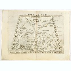
Tabula II Asiae.
A striking example of this wood-cut map depicts north of the Black Sea and west of the Caspian Sea (Ukraine, Russia, Georgia and Armenia). Ptolemy collected his data arou...
- $550 / ≈ €480
Date: Lyons, 1535
Tabula I Asiae.
Ptolemaic map of Turkey.From Lorenz Fries' edition of Ptolemy's Geographia, largely based on the 1513 map by Waldseemuller. "The elaborate Renaissance woodcut panels...
- $750 / ≈ €655
Date: Vienna, 1490, 1535
Leaf on vellum from a printed Book of Hours.
24 lines of printed text, surrounded by renaissance borders decorated with flowers, vases and religious scenes.From the press of the leading Parisian publisher and illumi...
- $125 / ≈ €109
Date: Paris, Germain Hardouyn, c.1520-1540
Leaf on vellum from a printed Book of Hours.
21 lines of printed text, surrounded by Renaissance borders decorated with flowers and little miniatures with figures on both sides.From the press of the leading Parisian...
- $125 / ≈ €109
Date: Paris, Germain Hardouyn, c. 1520-1540

Tabula Sexta Asia (Arabian Peninsula)
This is a very desirable early Ptolemaic woodblock map of the Arabian Peninsula, here called Arabia Felix. The map is presented on a trapezoidal projection with par...
Date: Vienna, 1525 -1541
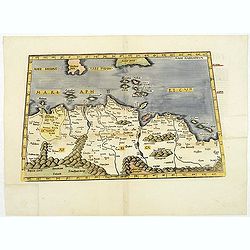
.Aphricae Tabula secunda continet.
An important early map of the northern coast of Africa and including parts of the islands of Sicily and Sardine.
Date: Vienne, 1541
![[Arabian Peninsula]](/uploads/cache/33869-250x250.jpg)
[Arabian Peninsula]
Wood block printed map and one of earliest printed representation of the Arabian Peninsula prepared by Martin Waldseemüller. Based on the slightly larger map from 1513 p...
Date: Vienna, Trechsel, G., 1525 -1541
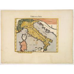
.Tabula nova Italiae. (Modern Italy)
Wood block printed modern map of Italy, prepared by Lorenz Fries and one of the earliest modern maps of Italy and environs. Based on the slightly larger map from 1513 pub...
Date: Vienna, 1525 -1541
![Tabula XII - Asiae [Taprobana Ins - Ceylon/Sri Lanka]](/uploads/cache/40249-250x250.jpg)
Tabula XII - Asiae [Taprobana Ins - Ceylon/Sri Lanka]
Map of Taprobana (Sri Lanka) which depicts the typical misconceptions of Ptolemy showing the island greatly enlarged, surrounded by imaginary islands, and with a small pa...
Date: Vienne, 1541
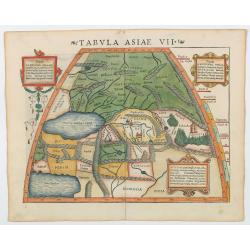
Tabula Asiae VII.
Attractive woodblock map, depicting the Caspian Sea, Black Sea and the Persian Gulf, extending to the Imaus Mountains. according to Ptolemy. In the center of the map is...
- $500 / ≈ €437
Date: Basle, 1542
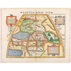
Tabula Asiae VII.
Attractive woodblock map, depicting the Caspian Sea, Black Sea and the Persian Gulf, extending to the Imaus Mountains, according to Ptolemy. In the center of the map is ...
Date: Basle, 1542
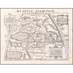
Tabula Asiae VII.
Attractive woodblock map, depicting the Caspian Sea, Black Sea and the Persian Gulf, extending to the Imaus Mountains. according to Ptolemy. In the center of the map is...
Date: Basle, 1542
![[Map of Turkey]](/uploads/cache/31502-250x250.jpg)
[Map of Turkey]
Page with an early representation of Turkey with Cyprus and Syria. This text page with a fine wood block printed map is from the rare work "C. Iulii Solini Polyhisto...
- $275 / ≈ €240
Date: Basle, Michael Isengrin, 1544
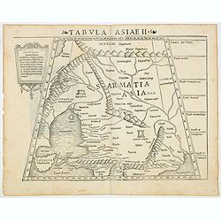
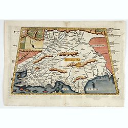
Tabula Asiae II (Black Sea and Caspian Sea)
The first edition of Munster's map of Ukraine and the region north of the Black Sea, based upon Claudius Ptolemy which appeared in his "Geographia Universalis",...
- $500 / ≈ €437
Date: Basel, Heinrich Petri, 1545
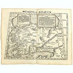
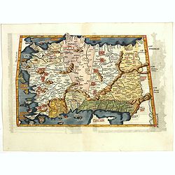
Tabula Asiae I (Turkey)
The first edition of Munster's map of Turkey, based upon Claudius Ptolemy which appeared in his "Geographia Universalis", first published in 1540. The Geographi...
- $500 / ≈ €437
Date: Basel, Heinrich Petri, 1545
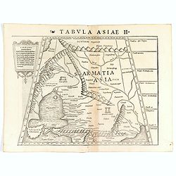
Tabula Asiae II (Black Sea and Caspian Sea).
The first edition of Münster's map of Ukraine and the region north of the Black Sea, based upon Claudius Ptolemy which appeared in his "Geographia Universalis"...
- $400 / ≈ €349
Date: Basel, Heinrich Petri, 1545
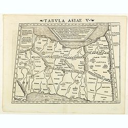
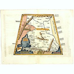
Tabula Asiae V. (Persia)
The first edition of Munster's map between the Persian Gulf and the Caspian Sea, extending from Armenia and Mesopotamia eastward, based upon Claudius Ptolemy which appear...
- $300 / ≈ €262
Date: Basel, Heinrich Petri, 1545
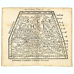
Scythia.
Woodblock engraved map covering the region between the Caspian and the Sea of China, much of which is Terra Incognita in the North and East. In 1546 Honter’s Cosmograph...
- $190 / ≈ €166
Date: Zürich, 1546

Tabula Asiae IIII. (Cyprus, Holy Land, Syria, Jordan, Iraq)
Gastaldi's map showing Cyprus, the Holy Land, Syria, Jordan and Iraq, based upon Ptolemy's map It is one of the earliest obtainable maps of the region.From Giacomo Gastal...
- $350 / ≈ €306
Date: Venice, 1548
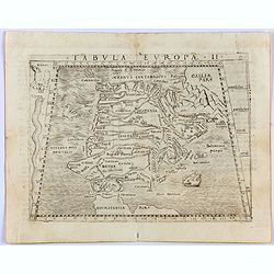
Tabula Europae II. (Spain and Portugal)
Gastaldi's map showing Spain and Portugal, based upon Ptolemy.It is one of the earliest obtainable maps of the region.From Giacomo Gastaldi's Atlas of 1548 which has been...
- $375 / ≈ €328
Date: Venice, 1548
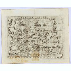
Tabula Asiae I.
Gastaldi's map of Asia Minor and the Bosporus Straits, based upon Ptolemy.It is one of the earliest obtainable maps of the region .From Giacomo Gastaldi's Atlas of 1548 w...
- $400 / ≈ €349
Date: Venice, 1548
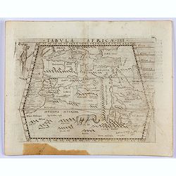
Tabula Africae IIII.
Gastaldi's map of Northern Africa, based on Ptolemy. Showing all of the Mediterranean, the Ethiopian Interior, the Red Sea, Egypt, the source of the Nile, the Dead Sea, e...
- $400 / ≈ €349
Date: Venice, 1548
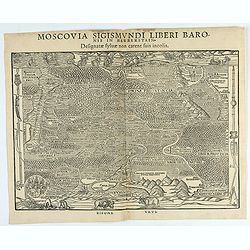
Moscovia Sigismundi Liberi Baronis In Herberstein, Neiperg et Gutehnag Anno M.D XLIX
First Modern Map of Russia. A rare and important cornerstone map for Russia collections.Sigismund von Herberstein made two visits to Russia. In 1517-18 he travelled as a ...
Date: Vienna, 1549
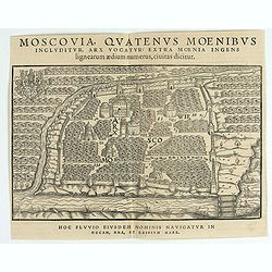
Moscovia Sigismundi Liberi Baronis In Herberstein, Neiperg et Gutehnag Anno M.D XLIX
The forst modern plan of Moscow. A rare and important cornerstone map for Russia collections.Sigismund von Herberstein made two visits to Russia. In 1517-18 he travelled ...
Date: Vienna, 1549

Della Graecia Ritratto di Costantinopoli hora stanza del Turco.
Early bird's eye view of Constantinople. From an Italian text edition of S. Münster's Cosmographia, which is a short and complete summary of Renaissance knowledge.
Date: Basle, 1550
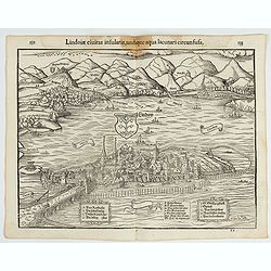
Lindoiae civitas insularis, undique aqua lacunari circunsusa.…
A wood block printed early bird's-eye view of Lindau on Lake Constance (Germany). A lettered key A-O in the plate. From the 1552 Latin text edition of Münster's Cosmogra...
Date: Basel, 1552
![[Lot of 2 leaves] Rubeaquum cum arce Isenburgo…/ Wyssenburg…](/uploads/cache/48269-250x250.jpg)
[Lot of 2 leaves] Rubeaquum cum arce Isenburgo…/ Wyssenburg…
Two wood block printed early bird's-eye views of Rouffach (lies along the Alsatian wine route) and Wissembourg (Alsace). From the 1552 Latin text edition of Münster's Co...
Date: Basel, 1552
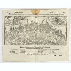
Colonia Agrippina civitas…
A wood block printed early panoramic view of Cologne (Germany). A lettered key A-Z beneath the view. The 1552 Latin text edition of Münster's Cosmographia is a short and...
- $70 / ≈ €61
Date: Basel, 1552
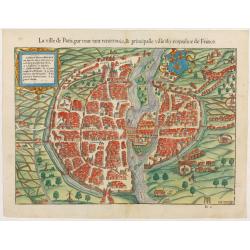
La ville de Paris, par tout tant renommée & principalle ville du royaulme de France.
Very early birds-eye view of Paris. From his Cosmographia, that great compendium of Renaissance knowledge. An exciting print.Engraved by Hans Rudolf Manuel-Deutsch(1525-1...
Date: Bâle, H. Petri, 1552
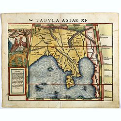
Tabula Asiae XI.
Attractive early woodblock map of the Indian Ocean, extending from Southeast Asia to the Ganges River and north to the Himalayas.In upper left inset panel of tiger, cocke...
- $600 / ≈ €524
Date: Basle, H. Petri, c. 1552
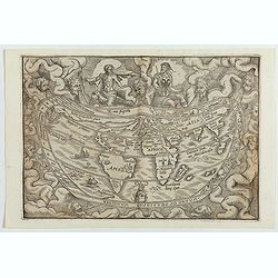
Typus Universalis Terrae, Iuxta Modernorum Distinctionem Et Extensionem Per Regna Et Provincias.
FIRST BLOCK - Rare world map from Gregor Reisch's Magarita Philisophica, published in Basle in 1583.In 1544, Peter Apian incorporated a world map into his Cosmographia, b...
Date: Antwerp c.1544-1553
-250x250.JPG)
Fiandra Brabantia et Holanda nvova
Fiandra Brabantia et Holanda nvovaDella Fiandra Brabantia, et Olanda quinta nvova tavola d’EuropaThis map is the first known map of the Netherlands as a whole. It comes...
Date: Venetië, 1561
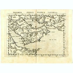
Arabia Felice Nuova Tavola.
Uncommon first edition of this modern map of Saudi Arabia, the Persian Gulf and Red Sea, for the first time it "clearly shows the island of Bahrain and Qatar".T...
Date: Venice, Vincenzo Valgrisi, 1561
Tabula Asiae II.
Scarce FIRST edition of this map of the ancient region of Asiatic Sarmatia - now Southern Russia and part of Ukraine, around the Azov seaGirolamo Ruscelli's edition of Pt...
- $300 / ≈ €262
Date: Venice, 1561
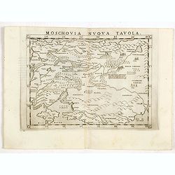
Moschovia nuova tavola.
Scarce FIRST edition of this map centered on Moscow. In the lower left Crimea and the Sea of Azov. The map is filled with small tents to represent Tartar camps.Girolamo R...
- $300 / ≈ €262
Date: Venice, 1561
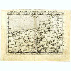
Tavola nuova di Prussia et di Livonia.
Uncommon first edition of this early map of the region from Pomerania to Livonia, includes a portion of Estonia, and coastal detail on the Baltic Sea with a small section...
- $400 / ≈ €349
Date: Venice, Vincenzo Valgrisi, 1561
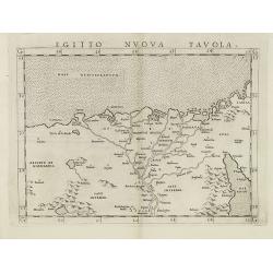
Egitto nuova tavola.
Fine early map of Egypt and the Nile delta. Extends east to the Upper Red Sea and West to "Deserto De Marmarica". Nice detail in the lower Nile regions. Page ta...
- $200 / ≈ €175
Date: Venice, 1561
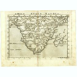
Africa nuova tavola.
Uncommon first edition of this early map of South Africa. Madagascar is called Isola de S. Lorenzo and is oddly shaped.The origin of the Nile conforms to the Ptolemaic co...
- $550 / ≈ €480
Date: Venice, Vincenzo Valgrisi, 1561
![Arabia Felice Nuova Tavola. [Arabian Peninsular]](/uploads/cache/40089-250x250.jpg)
Arabia Felice Nuova Tavola. [Arabian Peninsular]
Fine early map of this modern depiction of the Arabian peninsula, being one of the earliest modern maps of the region. The map extends from the Arabian Desert south as fa...
Date: Venice, Vincenzo Valgrisi, c.1561
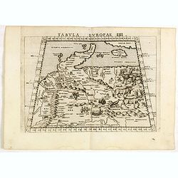
Tabula Europae IIII.
The scarce FIRST edition of this classical map depicting Northern Europe, Denmark and the Baltic. Includes engravings of a number of interesting animals in the right-hand...
- $450 / ≈ €393
Date: Venice, 1561
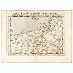
Tavola nuova di Prussia et di Livonia.
Uncommon first edition of this early map of the region from Pomerania to Livonia, includes a portion of Estonia, and coastal detail on the Baltic Sea with a small section...
Date: Venice, Vincenzo Valgrisi, 1561
