Browse Listings in Asia > South East Asia
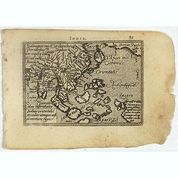
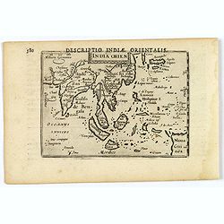
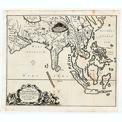
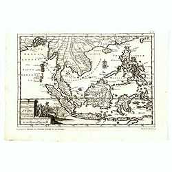
Indiae Orientalis, Insularumque Adiacentium Typus.
Map of Indonesia. From a French text edition of this illustrated treatise of geography, which is considered as the first modern pocket-atlas.Map engraved by Philip Galle....
- $500 / ≈ €437
Date: Antwerp, 1585
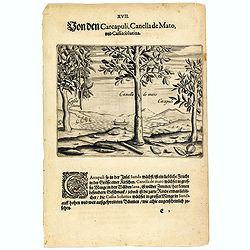
The carcapuli, canella de mato and cassia solutiva.
The ‘caarcapuli’ that grows on the island of Sunda is a tasty, cherry-sized fruit. The Canella de mato that grows in abundance in the forests of Java is wild cinnamon...
- $80 / ≈ €70
Date: Frankfurt, 1598
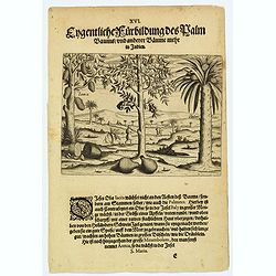
A picture of various trees including the palm tree.
The Jacca fruit grows only on the trunk of the tree, not on its branches, rather like the fruit of the palmates. Then there is a fruit that grows in abundance in Bali, wh...
- $80 / ≈ €70
Date: Frankfurt, 1598
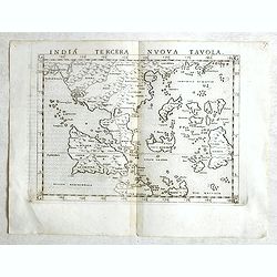
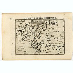
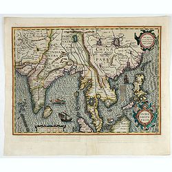
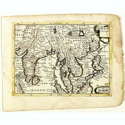
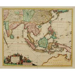
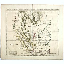
India Tercera Nuova Tavola.
Fine 1598 edition of this early map of South East Asia. Just to the west and south of Malacca, one will notice ‘Camatra’ (Sumatra) and Java. China with Canton in the ...
- $1000 / ≈ €874
Date: Venice, 1598
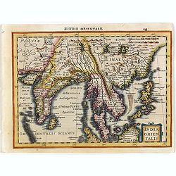
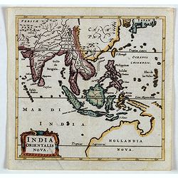
India Orientalis.
This lovely miniature map shows the East Indies, stretching from Persia to China and Japan, down to Java, and part of Papua new Guinea. Published by Petrus Bertius, in Am...
Date: Amsterdam, 1606
India Orien.
A miniature map showing India and the islands of Borneo, New Guinea, Sumatra, Java, etc.Korea as an enlonged peninsular and one town marked.First published in 1598 in his...
- $400 / ≈ €349
Date: Amsterdam, Cornelis Claes, 1606
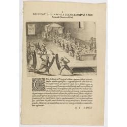
I. Delineatio convivii a Ternatensium rege Generali Neccio exhibiti.
This famous and desirable scene from Roelof Roelofsz's narrative of a voyage by J.C. van Neck to Ternate.Theodore de Bry, a German engraver and book dealer, began a compi...
- $100 / ≈ €87
Date: Frankfurt, Wolfgangi Richteri, 1607
![[Description de la Figure de la ville de Gammelamme - Description du N° 15]](/uploads/cache/43504-250x250.jpg)
[Description de la Figure de la ville de Gammelamme - Description du N° 15]
View of the town of Gammelamme [Gamalama] on Ternate, where the Dutch established a trading post. Text engraving from "Premier livre de l'histoire de la navigation a...
- $50 / ≈ €44
Date: Amsterdam, Cornille Nicolas, 1609
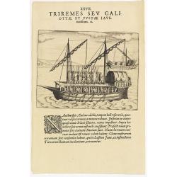
XXVII. Triremes seu Galiottae et Fustae Iavenenfium. 21. ( A typical Javanese man-of-war ship)
A typical Javanese man-of-war ship. The Javanese call their man-of-war ships, Cathurs. The slaves are all seated below deck and do the rowing with oars, while the warrior...
- $150 / ≈ €131
Date: Frankfurt, 1609
![[Javanese gamelan orchestra]](/uploads/cache/37960-250x250.jpg)
[Javanese gamelan orchestra]
Two text engravings from "Premier livre de l'histoire de la navigation aux Indes Orientales, par les hollandois, et des choses a eux advenues . . . ", being the...
- $75 / ≈ €66
Date: Amsterdam, Cornille Nicolas, 1609
![[Sunda].](/uploads/cache/37956-250x250.jpg)
[Sunda].
Text engraving and coastal profiles in wood block from "Premier livre de l'histoire de la navigation aux Indes Orientales, par les hollandois, et des choses a eux ad...
Date: Amsterdam, Cornille Nicolas, 1609
![[Chinese Merchants and temple].](/uploads/cache/37966-250x250.jpg)
[Chinese Merchants and temple].
Two text engravings of Chinese merchants on Java and a Chines temple from "Premier livre de l'histoire de la navigation aux Indes Orientales, par les hollandois, et ...
- $100 / ≈ €87
Date: Amsterdam, Cornille Nicolas, 1609
![[Native Flora of Java].](/uploads/cache/37964-250x250.jpg)
[Native Flora of Java].
Text engraving of native flora of Java from "Premier livre de l'histoire de la navigation aux Indes Orientales, par les hollandois, et des choses a eux advenues . . ...
- $75 / ≈ €66
Date: Amsterdam, Cornille Nicolas, 1609
![[Bantam].](/uploads/cache/37963-250x250.jpg)
[Bantam].
Text engraving showing some merchants of Bantam, from "Premier livre de l'histoire de la navigation aux Indes Orientales, par les hollandois, et des choses a eux adv...
- $75 / ≈ €66
Date: Amsterdam, Cornille Nicolas, 1609
![[Sumatra]](/uploads/cache/37955-250x250.jpg)
[Sumatra]
Text engraving from "Premier livre de l'histoire de la navigation aux Indes Orientales, par les hollandois, et des choses a eux advenues . . . ", being the clas...
- $50 / ≈ €44
Date: Amsterdam, Cornille Nicolas, 1609
![[Ternate].](/uploads/cache/37954-250x250.jpg)
[Ternate].
Text engraving showing a bay on the Island of Ternate, an island in the Maluku Islands (Moluccas) of eastern Indonesia. Above the map a lettered key (A-E). Text engraving...
- $100 / ≈ €87
Date: Amsterdam, Cornille Nicolas, 1609
![[Ambon].](/uploads/cache/37953-250x250.jpg)
[Ambon].
Text engraving showing a bay on the Island of Ambon, an island in the Maluku Islands (Moluccas) of eastern Indonesia. Above the map a lettered key (A-D). Text engraving f...
- $150 / ≈ €131
Date: Amsterdam, Cornille Nicolas, 1609
![[Plants and fruits of the East Indies].](/uploads/cache/37951-250x250.jpg)
[Plants and fruits of the East Indies].
Two text engravings from "Premier livre de l'histoire de la navigation aux Indes Orientales, par les hollandois, et des choses a eux advenues . . . ", being the...
- $50 / ≈ €44
Date: Amsterdam, Cornille Nicolas, 1609
![[Celebrating the arrival of the Dutch in Turban].](/uploads/cache/37949-250x250.jpg)
[Celebrating the arrival of the Dutch in Turban].
Text engravings of a tournament in Turban. On 23rd January 1599, the Dutch landed at Turban (on the north coast of Java) with several small boats. Great crowds of people ...
- $150 / ≈ €131
Date: Amsterdam, Cornille Nicolas, 1609
![[Dutch ship Amsterdam].](/uploads/cache/37948-250x250.jpg)
[Dutch ship Amsterdam].
Text engraving of the Dutch vessel Amsterdam offshore the island of Java near Surabaya from "Premier livre de l'histoire de la navigation aux Indes Orientales, par l...
Date: Amsterdam, Cornille Nicolas, 1609
![[Javanese Vessels]](/uploads/cache/37947-250x250.jpg)
[Javanese Vessels]
Two text engravings from "Premier livre de l'histoire de la navigation aux Indes Orientales, par les hollandois, et des choses a eux advenues . . . ", being the...
- $100 / ≈ €87
Date: Amsterdam, Cornille Nicolas, 1609
![[Foreign Merchants at Bantam].](/uploads/cache/37943-250x250.jpg)
[Foreign Merchants at Bantam].
Two text engravings from "Premier livre de l'histoire de la navigation aux Indes Orientales, par les hollandois, et des choses a eux advenues . . . ", being the...
- $100 / ≈ €87
Date: Amsterdam, Cornille Nicolas, 1609
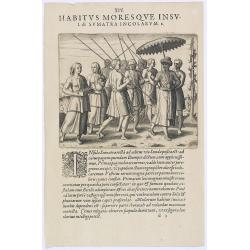
Habitus Moresque Insulae Sumatra Incolarum. (People of Sumatra)
People of Sumatra.Theodore de Bry, a German engraver and book dealer, began a compilation of early voyages in 1590 and had published six parts at the time of his death in...
- $100 / ≈ €87
Date: Frankfurt, 1609
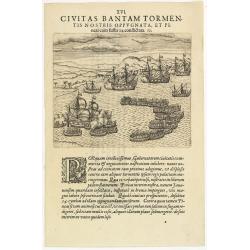
XVI. Civitas Bantam Tormentis nostris oppugnata . . .
Attack of Bantam (Banten), a city and former sultanate on Java island.Theodore de Bry, a German engraver and book dealer, began a compilation of early voyages in 1590 and...
- $100 / ≈ €87
Date: Frankfurt, 1609
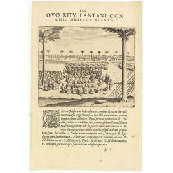
XXV. Quo Ritu Bantani Concilia Militaria Agant. 19. (Councils meeting at Bantam)
Councils meeting at Bantam (Banten), a city and former sultanate on Java island. Theodore de Bry, a German engraver and book dealer, began a compilation of early voyages ...
- $100 / ≈ €87
Date: Frankfurt, 1609
![[Bantam].](/uploads/cache/37941-250x250.jpg)
[Bantam].
Text engraving showing the arrival of the Dutch fleet at Bantam from "Premier livre de l'histoire de la navigation aux Indes Orientales, par les hollandois, et des c...
- $150 / ≈ €131
Date: Amsterdam, Cornille Nicolas, 1609
![[Bantam]](/uploads/cache/37939-250x250.jpg)
[Bantam]
Two text engravings from "Premier livre de l'histoire de la navigation aux Indes Orientales, par les hollandois, et des choses a eux advenues . . . ", being the...
- $100 / ≈ €87
Date: Amsterdam, Cornille Nicolas, 1609
![[View of the arrival of Cornelis de Houtman's fleet at Bantam, Java.].](/uploads/cache/37937-250x250.jpg)
[View of the arrival of Cornelis de Houtman's fleet at Bantam, Java.].
Engraved map of Bantam on Java with a lettered key (A-N) showing the arrival of Cornelis de Houtman’s fleet at Bantam, Java in 1596. Houtman’s four vessels, the Amste...
- $200 / ≈ €175
Date: Amsterdam, Cornille Nicolas, 1609
![[Tropical fruits of Java].](/uploads/cache/37934-250x250.jpg)
[Tropical fruits of Java].
Two text engravings of fruits on Java from "Premier livre de l'histoire de la navigation aux Indes Orientales, par les hollandois, et des choses a eux advenues . . ....
- $75 / ≈ €66
Date: Amsterdam, Cornille Nicolas, 1609
![[Java Fruits].](/uploads/cache/37933-250x250.jpg)
[Java Fruits].
Text engraving of fruits on Java from "Premier livre de l'histoire de la navigation aux Indes Orientales, par les hollandois, et des choses a eux advenues . . . &qu...
- $75 / ≈ €66
Date: Amsterdam, Cornille Nicolas, 1609
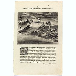
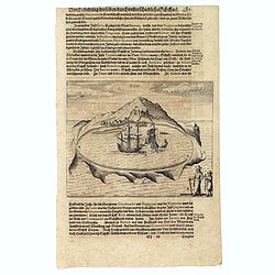
Delineatio Piscationum Ternatensis.
Fishing scene on Ternate island, Maluku, Indonesia.Theodore de Bry, a German engraver and book dealer, began a compilation of early voyages in 1590 and had published six ...
- $80 / ≈ €70
Date: Frankfurt, 1609
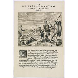
Milites in Bantam Gregarii Gum Suis armis. (Warriors of Bantam)
The warriors of Bantam carry both small and large shields made of leather, also swords or long lances with sturdy spear-heads. Their clothing is made with little square p...
- $75 / ≈ €66
Date: Frankfurt, 1609
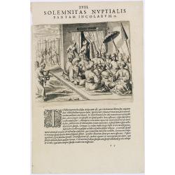
Solemnitas Nuptialis Bantam Incolarum. (A wedding ceremony in the city of Bantam)
When a young couple become engaged they do not leave their homes until the wedding takes place. On their wedding day they are dressed up and happy, and visited by all the...
- $75 / ≈ €66
Date: Frankfurt, 1609
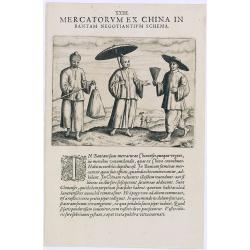
Mercatorum Ex China in Bantam Negotiantium Schema.
An early portrait of Chinese merchants in Banten (Bantam), a small port town near Java's western end.Theodore de Bry, a German engraver and book dealer, began a compilati...
- $100 / ≈ €87
Date: Frankfurt, 1609
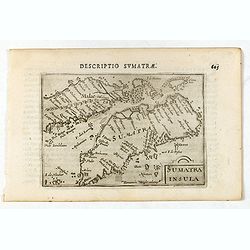
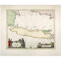
Sumatra Insula.
A miniature map of Sumatra containing detailed geography and nomenclature around the entire island. The neighbouring coast of the Malay Peninsula is shown, including Sing...
- $450 / ≈ €393
Date: Amsterdam/Frankfurt 1609
India Orientalis.
Published in Hondius' editions of the Mercator Atlas from 1606 onwards, showing the Indian subcontinent, the Malay Peninsula, Siam and Cambodia, China and the Philippines...
Date: Amsterdam, 1630
India Orientalis.
Map covering India, Thailand, Philippines, Northern Borneo and the coast of Southern China. From the rare Cloppenburg edition "Atlas Sive Cosmographicae Meditationes...
- $550 / ≈ €480
Date: Amsterdam, 1630
![[The Dutch reach Annabon.]](/uploads/cache/40075-250x250.jpg)
[The Dutch reach Annabon.]
Eight days after leaving the mainland, the Dutch arrived at one of the Annabon islands (Pagalu), where they asked the Portuguese and Moors, who were occupying the island,...
Date: Frankfurt, M.Merian, 1633
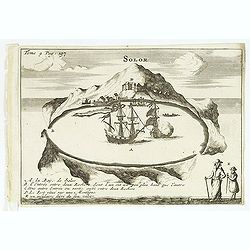
Solor.
Scarce print on German text sheet showing the Island of Solor. From "Petits Voyages". The island Solar, to the north of Timor, has a high mountain and has a ver...
- $100 / ≈ €87
Date: Frankfurt, M.Merian, 1633
![Les Petit Voyages [Solor].](/uploads/cache/37958-250x250.jpg)
Les Petit Voyages [Solor].
This work by de Bry comprises probably the greatest single collection of material on early voyages to the East Indies, and are unique in their extraordinary wealth of car...
- $100 / ≈ €87
Date: Frankfurt, 1601 - 1633
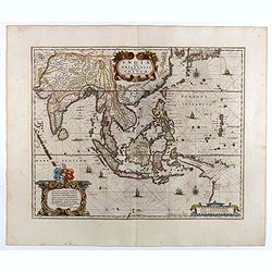
India quae Orientalis dicitur, et Insulae Adiacentes.
Map of South East Asia, noteworthy for being one of the first maps to include, albeit incompletely, the discoveries made by the Dutch vessel Duyfken in 1605-1606 in the G...
- $1750 / ≈ €1529
Date: Amsterdam, 1638
India quae Orientalis dicitur, et Insulae adiacentes.
A fine map of South East Asia, extending from India to Tibet to Japan to New Guinea. Formosa appears on this map, and even parts of Japan and Australia are seen. A handso...
- $1850 / ≈ €1616
Date: Amsterdam, 1640
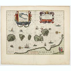
Moluccae Insulae Celeberrimae.
Showing the geographical features of the islands, and decorated with ships, sea monsters and a handsome cartouche. With an inset of Bachian island. From early on Willem ...
- $750 / ≈ €655
Date: Amsterdam, 1644
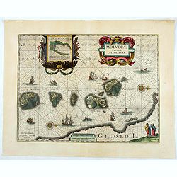
Moluccae Insulae Celeberrimae.
Showing the geographical features of the islands and decorated with ships, sea monsters and a handsome cartouche. With an inset of Bachian island. From early on Willem J...
- $750 / ≈ €655
Date: Amsterdam, ca.1645
![Ins. de Cerno a. Nostatibus Mauritius Nominata [on sheet with] Gunnanappi Labetacq [and] Civitas Gammelamme [and] Rex Tubatus.](/uploads/cache/48504-250x250.jpg)
Ins. de Cerno a. Nostatibus Mauritius Nominata [on sheet with] Gunnanappi Labetacq [and] Civitas Gammelamme [and] Rex Tubatus.
Three views and one map on one page: Shows natives on Mauritius fishing and building a boat, with a dodo and two turtles at right; The Banda islands; A procession for th...
Date: Amsterdam, c.1646
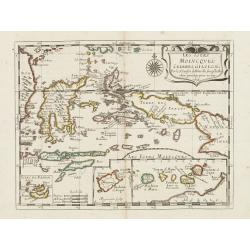
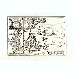
Insulae Iavae Cum parte insularum Borneo Sumatrae..
An elegant sea chart of the island of Java with parts of Sumatra, Borneo and Bali. The map includes only coastal detail and shows the Dutch capital in the East Indies at ...
Date: Amsterdam, 1652
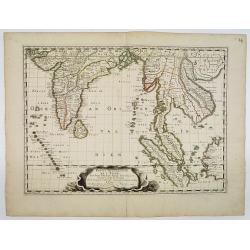
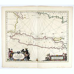
Partie Meridionale De L'Inde En deux Presqu'Isles l'une deca et l'autre Gange . . . 1654
Sanson's important mid-seventeenth-century map of India and Southeast Asia. At a scale of about 1:9,000,000, it covers most of modern India, Bangladesh and Burma, the who...
Date: Paris, 1654
India Orientalis Nova.
Charming uncommon miniature map showing the northern two-thirds of Australia pre-discoveries by Captain Cook, but showing discoveries by Abel Tasman in 1642. The map show...
- $750 / ≈ €655
Date: Amsterdam, 1659
Insulae Iavae Cum parte Insularum Borneo Sumatrae, et Circumjacentium Insularum Novissima Delineatio.
This elegant chart focuses on the island of Java with parts of Sumatra, Borneo and Bali. The lack of interior detail correctly reflects the state of knowledge of the peri...
Date: Amsterdam, 1660
Inde Orientale. (22).
Scarce map of India, the East Indies, Philippines and Malaysia published by Antoine de Fer in 1661 or 1662 in "Cartes de géographie revues et augmentées". Wit...
- $250 / ≈ €218
Date: Paris, Antoine de Fer, 1657 but 1661 or 1662
Tabula Geographica Hydrophylacium Asiae Majoris exhibens, quo Omnia Flumina sive proxime sive remote per occultos maeandros Originem suam Sortiuntur.
Rare and Interesting map showing Asia from Arabia in the west until China, Japan, Korea and Philippines with Indonesia. From Kircher's "Mundus Subterranaeus". ...
- $300 / ≈ €262
Date: Amsterdam, 1665
Les Iles Molvcques, Celebes, Gilolo. . .
Map of the Indian Ocean Islands of the Moluccas Islands prepared by N.Sanson and published by Pierre Mariette.Published in an early edition of the small Sanson atlas L'Eu...
Date: Paris, P. Mariette, 1667
Indiae Orientalis nec non Insularum adiacentium.
Fine map of South East Asia from India to New Guinea with Japan and the southern tip of Korea in the upper right. The map leaves the question of Torres Straits unanswered...
- $1800 / ≈ €1572
Date: Amsterdam, 1680
![Isole dell 'India cioè le Molucche le Filippine e della Sonda . . . [East Indies].](/uploads/cache/39593-250x250.jpg)
Isole dell 'India cioè le Molucche le Filippine e della Sonda . . . [East Indies].
In lower left hand corner a large title cartouche, decorated with mermaids, mermen and playful putti. A scarce, uncommon, late 17th century map of South East Asia, based ...
- $1800 / ≈ €1572
Date: Rome, 1683
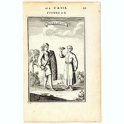
Molucquois (De L'Asie / figure LX).
A fine and uncommon early 17th century print of two people from Moluccas.From the French text edition of "Description d'Univers", 1683. by Allain Manneson Malle...
- $80 / ≈ €70
Date: Paris, 1683
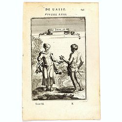
Habitants des Isles de la Sonde.
A fine and uncommon early 17th century print of two inhabitants of the Sunda Islands, East Indies (Indonesia).From the French text edition of Description d'Univers, 1683....
- $75 / ≈ €66
Date: Paris, 1683
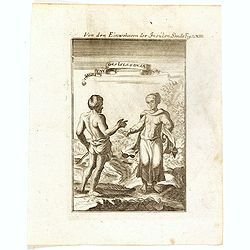
Von den Einwohnerne der Insulen Sonde (Fig LXIII).
A fine and uncommon early 17th century print of two inhabitants of the Sunda Islands, East Indies (Indonesia). Engraved by Joh. Jak. Vogel.By Allain Manneson Mallet (1630...
- $75 / ≈ €66
Date: Frankfurt, 1684
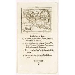
Insulae Sondae.
Rare small map of South East Asia, from "Kurtze bundige abbild und vorstellung der gantzen welt." by Johann Ulrich Muller. A second edition was published in Fra...
- $300 / ≈ €262
Date: Ulm, 1692
Nova Et Vera Exhibitio Gerographica Insularum Marianarum . . .
Attractive map of the Philippines, Japan, Korea and Indonesia with an inset of the island Guam, by the Jesuit Heinrich Scherer, printed in for Scherer's 'Atlas Novus'. Se...
- $1200 / ≈ €1048
Date: Munich, c.1702
Solor / A la Baye de Solor.
Decorative map of the Bay of Solor. With a lettered key (A - E). Solor is a volcanic island located off the eastern tip of Flores island in the Lesser Sunda Islands of In...
- $120 / ≈ €105
Date: Amsterdam, E. Rogers, 1703
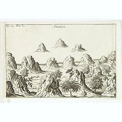
Anabon. (Ambon)
A fanciful view of a landscape on the island Ambon. From the French reissue of the account of early Dutch voyages first published in 1608 by Commelin. The French transla...
- $120 / ≈ €105
Date: Amsterdam, E. Rogers, 1703
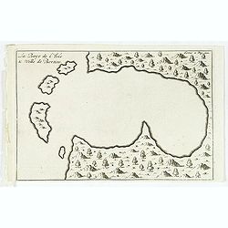
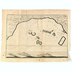
La Baye de l'Isle & ville de Borneo.
Uncommon map of a Bay on the island of Borneo. From the French reissue of the account of early Dutch voyages first published in 1608 by Commelin. The French translation w...
- $100 / ≈ €87
Date: Amsterdam, E. Roger, 1703
Indien onder den Heer Lopo Vaz De Sampayo, als Gouverneur Generaal tot aan Nieuw-Spanje in American on Kusten van Peru en Chili bevaaren.
Most decorative and scarce item, centred on Indonesia, including an incomplete coast of Australia, and west coast of America. The South Pacific is occupied by a large tit...
Date: Leiden, 1707
D'Indize kusten van Bengale, Pegu, Malacca en Siam Tot in China. . .
Map of Indonesia, Malacca with Singapore (Cingapura) and Taiwan in upper right corner. In lower left a fine title cartouche showing Duarte de Menezes.Although not renowne...
Date: Leiden, 1707
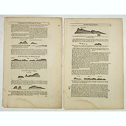
Two double sided pages No's 57, 58, 59, 60 (Directions for the coast of Sumatra and Strait Diron).
Text page with woodblock plofiles by Samuel Thornton showing the approaching coast lines of Sumatra, the Island of Quesan, Sampanna, Lamjett and Island of Hightan and &qu...
- $60 / ≈ €52
Date: London, 1711
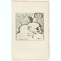
Ware affbeeldinge wegens het casteel ende stadt Batavia. . .
A reduced version of Clement de Jonghe (1650) plan of Jakarta from 1650. The town plan has a vignette at the bottom showing Jakarta from the sea with the volcanoes Mount ...
- $800 / ≈ €699
Date: Leiden, 1719
La Rade de Batavia . . .
Beautifully engraved map with elaborate cartouche of present-day Jakarta. From van der Aa's very rare work "La galerie agreable du Monde".
- $300 / ≈ €262
Date: Leiden, 1719
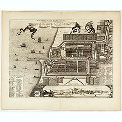
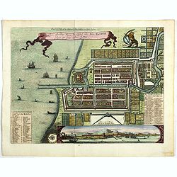
Plan de la Ville et du Chateau de Batavia en l'Isle de Java.
Detailed dual language plan of Batavia, the capital of the Dutch East Indies.Batavia, today’s Indonesian capital of Jakarta, was the center of Dutch economic activity i...
- $800 / ≈ €699
Date: Paris, 1719
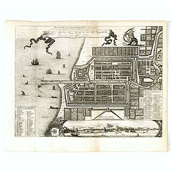
Waere affbeeldinge wegens het casteel ende stadt Batavia.
A good impression of Batavia's finely engraved and detailed plan, present-day Jakarta, the Dutch center of trading activities in the East Indies. Copied after Clement de ...
Date: Leiden, 1719
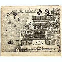
Waere affbeeldinge wegens het casteel ende stadt Batavia.
A good impression of this finely engraved and detailed plan of Batavia, present-day Jakarta, the Dutch center of trading activities in the East Indies. Copied after Cleme...
Date: Leiden, 1719

Carte de l'Ile de Java. . .
An inset plan of Batavia clearly indicates rice fields, mountains, forests, towns in profile, and even elephants, suggesting the wealth of detail found on this map. Model...
Date: Amsterdam, 1720
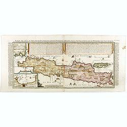
Carte de l'Ile de Java: partie Occidentale, partie Orientale, Dressée tout nouvellement sur les Mémoirs les plus exacts, Avec une Table des principales villes de cette Ile. . .
One of the finest large-scale maps of Java, giving good information regarding the VOC settlements An inset plan of Batavia and clearly indicated rice fields, mountains, f...
- $1500 / ≈ €1310
Date: Amsterdam, 1720
Le Royaume de Siam avec Les Royaumes Qui Luy sont Tributaries & c.
Influential map of Southeast Asia, including modern day Thailand, southern Vietnam, Cambodia, Malaysia, Singapore, Borneo, Sumatra and Java. Chatelain incorporated inform...
Date: Amsterdam, c.1720

Carte des Indes, de la Chine & des Isles de Sumatra, Java &c..
This fine and quite detailed general map extends from northern Japan to Timor and from India to New Guinea.There are very good details of towns and trade routes in modern...
Date: Amsterdam, 1720
(Bird's eye view of the Bay of Bantam)
Early view of the Bay of Bantam with the islands of Pulo dua and Batto.Bantam was always a product of the ferocious commercial rivalry between the Dutch and English and P...
- $75 / ≈ €66
Date: Amsterdam, F. Bernard, 1725
La Baye de l'Isle & ville de Borneo.
Uncommon map of a Bay on the island of Borneo. From the French reissue of the account of early Dutch voyages first published in 1608 by Commelin. The French translation w...
- $75 / ≈ €66
Date: Amsterdam, F. Bernard, 1725
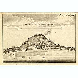
Ternate, par son aspect oriental.
This map is a view of Ternate with the summit of Gamalama from Dodoku Ali. From the French reissue of the account of early Dutch voyages first published in 1608 by Commel...
- $75 / ≈ €66
Date: Amsterdam, J.F. Bernard, 1725
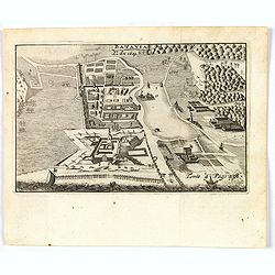
Batavia, L'an 1629.
Scarce town-view of Batavia (Jakarta) in 1629.From the French reissue of the account of early Dutch voyages first published in 1608 by Commelin. The French translation wa...
- $150 / ≈ €131
Date: Amsterdam, 1725
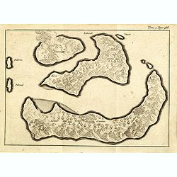
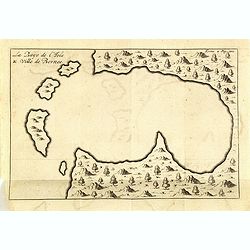
(Gunanappi / Wayer / Nera / Pulorin / Puloway .)
Uncommon map of islands in the Banda Sea. Several islands and villages are named, Wayer, Nera, Pulorin, Puloway, Lontoor, Ortattan and Combeer.From the French reissue of ...
- $75 / ≈ €66
Date: Amsterdam, F. Bernard, 1725
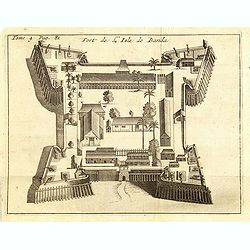
Fort de l'Isle de Banda.
Decorative print of the Dutch VOC fortress on the island Banda. Until the mid-19th century the Banda Islands were the world's only source of the spices nutmeg and mace, p...
- $90 / ≈ €79
Date: Amsterdam, F. Bernard, 1725
