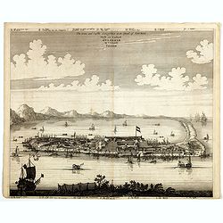
The citie and Castle Zelandia in the Island of Taywan. / Stadt en casteel Zelandia op 't Eilant Taywan.
This important copperplate engraving is one of the earliest European views of Taiwan, depicting the Dutch fortifications and trading settlements on the island's West coas...
Date: Amsterdam, 1675

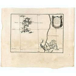
Description de l'Isle Formosa en Asie, du gouvernement, des
Complete title: Description de l'Isle Formosa en Asie, du gouvernement, des Moers & de la religion des habitans.Rare first French edition of one of the most famous fi...
Date: Amsterdam, 1705
Carte des Iles de Ponghou suivant le point sur lequel ont été faites les cartes de la Chine et de la Tartarie par l'ordre et aux frais de l'empereur. . .
Plan of the West coast of Taiwan and it direct environs. From "Lettres Édifiantes et Curieuses. . Missionaires de la Compagnie de Jesus [Jesuit Letters]". Engr...
- $175 / ≈ €153
Date: Paris, 1780-1783
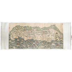
A rare and impressive pictorial Qing Empire map of the western part of Taiwan.
The top of the map faces east, the bottom faces west, and the left and right are north-south. It is about 120 cm high and 225 cm long. The map shows only to the west of t...
Date: ca. 1850
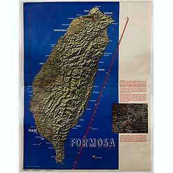
Formosa.
A large poster size map of the island of Formosa (Taiwan) off the Chinese mainland, prepared as a News Maps special edition during WWII. There is a red diagonal measureme...
- $750 / ≈ €655
Date: New York, 1943
