Browse Listings in Asia
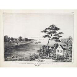
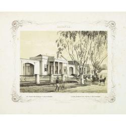
Factorij der Nederlanders op Firato.. 1609-1641.
Bird's-eye view of Hirado, a trading post of the V.O.C. from 1609 until 1641.Von Siebold was born in Wurzburg, in Germany, and worked for the Dutch government as a doctor...
- $1500 / ≈ €1310
Date: Leiden, 1832-1852
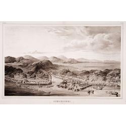
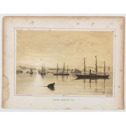
Simonoseki.
Bird's-eye view of Simonoseki, an important trading post in earlier times. Von Siebold was born in Wurtzburg, in Germany, and worked for the Dutch government as a doctor ...
- $1500 / ≈ €1310
Date: Leiden, 1832-1852
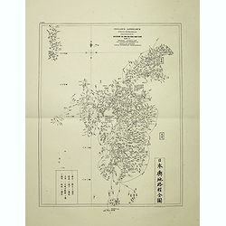
Insularum Japonicarum tabulae geographicae secundum opus NIPPON JO TSI RO TEI SEN TSU Tab. I Kiusui Insularum. . .
Fine map of the island if Kyushu, together with Tsushima Island with the bay of Nagasaki where in 1641 the man-made island of Deshima, trading post of the V.O.C. was est...
- $1000 / ≈ €874
Date: Leiden, 1832-1852
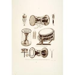
Muzijkinstrumenten.
Showing Japanese drums.Von Siebold was born in Würzburg, in Germany, and worked for the Dutch government as a doctor in Java. In Japan, where Von Siebold arrived in 1823...
- $200 / ≈ €175
Date: Leiden, 1832-1852
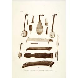
Muzijkinstrumenten.
Showing several Japanese string musical instruments, a.o.: Samisen and Kokiu.Von Siebold was born in Wurtzburg, in Germany, and worked for the Dutch government as a docto...
- $200 / ≈ €175
Date: Leiden, 1832-1852
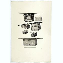
REISGEREEDSCHAPP. REISEGERAETHSCHAFT. Tab. II.
Japanese travel chests as used in a Dutch tributary embassy to the Tokugawa’s residence.Philipp Franz von Siebold (1796-1866) was a physician, researcher and teacher wh...
- $300 / ≈ €262
Date: Leiden, 1852

MUZJIKINSTRUMENTEN. MUSIKINSTRUMENTE. Tab.VI.
Several Japanese instruments.Philipp Franz von Siebold (1796-1866) was a physician, researcher, and teacher who joined the Dutch East Indian army and traveled to Japan on...
- $350 / ≈ €306
Date: Leiden, 1852
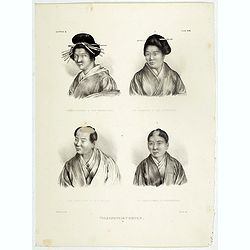
Volksphysionomien.
Showing farm and city boy and girl in typical dress and haircut.Von Siebold was born in Wurzburg, in Germany, and worked for the Dutch government as a doctor in Java. In ...
- $200 / ≈ €175
Date: Leiden 1832-1852
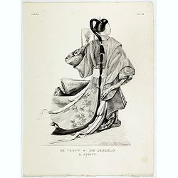
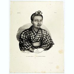
De Vrouw - Die Gemahlin der Sjogun.
Showing the wife of a shogun in typical kimono and hair cut. A Shogun and daimyo often had several wives to ensure the birth of an heir.Von Siebold was born in Wurzburg, ...
- $200 / ≈ €175
Date: Leiden 1832-1852
Een Japansch Meisje - Ein japanisches Madchen.
Portrait of a Japanese girl. Lithography made after a drawing made to nature by de Villeneuve., Von Siebold was born in Wurzburg, in Germany, and worked for the Dutch gov...
- $200 / ≈ €175
Date: Leiden 1832-1852
![Burgerdragt. [Japanese citzen in typical dress]](/uploads/cache/39349-250x250.jpg)
Burgerdragt. [Japanese citzen in typical dress]
Showing a Japanese citizen in a typical dress.Von Siebold was born in Wurzburg, in Germany, and worked for the Dutch government as a doctor in Java. In Japan, where Von S...
- $150 / ≈ €131
Date: Leiden 1832-1852
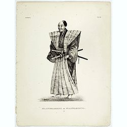
Staatiekleeding.
Showing a Japanese man's in official dress.Von Siebold was born in Wurzburg, in Germany, and worked for the Dutch government as a doctor in Java. In Japan, where Von Sieb...
- $175 / ≈ €153
Date: Leiden 1832-1852
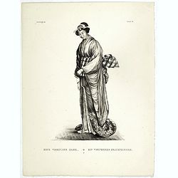
Eene Voorname Dame.
Showing a wife of a high-ranking person dressed in typical kimono. The tenno, kugyo (court officials), shogun and daimyo often had several wives to ensure the birth of an...
- $200 / ≈ €175
Date: Leiden 1832-1852
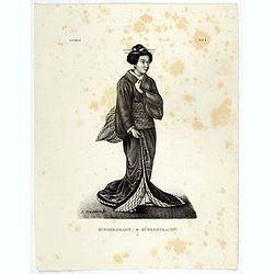
Burgerdragt.
Showing a Japanese citizen woman in kimono.Von Siebold was born in Wurzburg, in Germany, and worked for the Dutch government as a doctor in Java. In Japan, where Von Sieb...
- $200 / ≈ €175
Date: Leiden 1832-1852
![Eene Vorstin. [Japanese Empress]](/uploads/cache/39353-250x250.jpg)
Eene Vorstin. [Japanese Empress]
Showing Japanese Empress in kimono.Von Siebold was born in Wurzburg, in Germany, and worked for the Dutch government as a doctor in Java. In Japan, where Von Siebold arri...
- $200 / ≈ €175
Date: Leiden 1832-1852
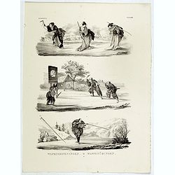
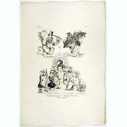
Wapenoefeningen - Tab XXIV. (Japanese martial art techniques)
Showing Japanese scenes of different martial art techniques.Von Siebold was born in Wurzburg, in Germany, and worked for the Dutch government as a doctor in Java. In Japa...
- $200 / ≈ €175
Date: Leiden 1832-1852
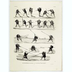
Wapenoefeningen - Tab XXIII. (Kendo training)
Showing Japanese scenes of Kendo training.Von Siebold was born in Wurzburg, in Germany, and worked for the Dutch government as a doctor in Java. In Japan, where Von Siebo...
- $300 / ≈ €262
Date: Leiden 1832-1852
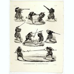
Wapenoefeningen - Tab XXII. (Kendo training)
Showing Japanese Kendo training.Von Siebold was born in Wurzburg, in Germany, and worked for the Dutch government as a doctor in Java. In Japan, where Von Siebold arrived...
- $300 / ≈ €262
Date: Leiden 1832-1852
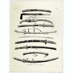
Wapenen.
Showing Japanese swords.Von Siebold was born in Wurzburg, in Germany, and worked for the Dutch government as a doctor in Java. In Japan, where Von Siebold arrived in 1823...
- $200 / ≈ €175
Date: Leiden 1832-1852
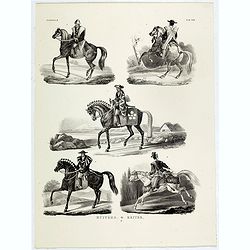
Ruiters.
Showing Japanese types of cavaliers.Von Siebold was born in Wurzburg, in Germany, and worked for the Dutch government as a doctor in Java. In Japan, where Von Siebold arr...
- $150 / ≈ €131
Date: Leiden 1832-1852
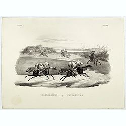
Harddravers.
Showing a Japanese scene of cavaliers training.Von Siebold was born in Wurzburg, in Germany, and worked for the Dutch government as a doctor in Java. In Japan, where Von ...
- $200 / ≈ €175
Date: Leiden 1832-1852
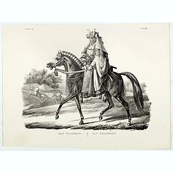
Een Veldheer.
Showing a Japanese cavalier.Von Siebold was born in Wurzburg, in Germany, and worked for the Dutch government as a doctor in Java. In Japan, where Von Siebold arrived in ...
- $300 / ≈ €262
Date: Leiden 1832-1852
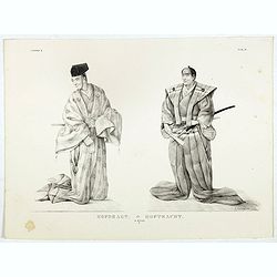
Hofdragt.
Showing different Japanese men's clothing at court.Von Siebold was born in Wurzburg, in Germany, and worked for the Dutch government as a doctor in Java. In Japan, where ...
- $250 / ≈ €218
Date: Leiden 1832-1852
Reisgereedschapp - Reisegeraethschaft.
Showing Japanese travel chests as used during a Dutch tributary embassy to the Tokugawa’s residence.Von Siebold was born in Wurzburg, in Germany, and worked for the Dut...
- $300 / ≈ €262
Date: Leiden 1832-1852
Muzik en dans.
Showing Japanese scenes of music and dance.Von Siebold was born in Wurzburg, in Germany, and worked for the Dutch government as a doctor in Java. In Japan, where Von Sieb...
- $150 / ≈ €131
Date: Leiden 1832-1852
![Wapenrusting. [Samurai armour]](/uploads/cache/39403-250x250.jpg)
Wapenrusting. [Samurai armour]
Showing Japanese Samurai armour.Von Siebold was born in Wurzburg, in Germany, and worked for the Dutch government as a doctor in Java. In Japan, where Von Siebold arrived...
- $300 / ≈ €262
Date: Leiden 1832-1852
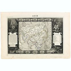
Carte de l'Asie.
Map of Asia framed by vignettes depicting costumes of the various peoples of Asia, Adam and Eve, and several exotic animals. Interesting population chart at right totalin...
Date: Paris, A. Combette, 1852
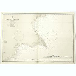
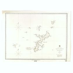
Cyprus south east coast Cape Kiti to Cape Eloea.
An British Admiralty chart of Cyprus south east coast. A highly corrected version of Admiralty chart 971 originally published 15th February 1866 under the Superintendence...
- $100 / ≈ €87
Date: London, 1852
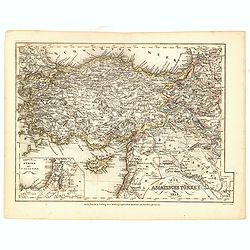
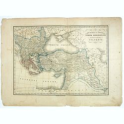
Die Asiatische Turkey 1854.
Steel engraved map, hand colored in outline when it was published. The detailed map shows the Asian part of Turkey, most of Syria, Iraq, Cyprus and the southern reaches o...
- $70 / ≈ €61
Date: Hildburghausen, Bibliograph Institut,1854
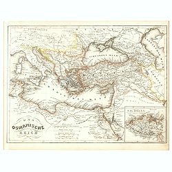
Das Osmanische Reich 1854.
From Meyer's Neuester Zeitungs Atlas. The map is well engraved in the German style with plenty of detail but minimal decoration. Inset map of the Nile Delta.
- $40 / ≈ €35
Date: Heidelberg, 1854
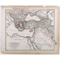
Das osmannische Reich und dessen Schutz-Staaten, nach seiner grossten Ausdehnung im XVIIten Jahrhundert.
Karl von Spruner's historical map of the Ottoman empire at the end of the 17th century. Showing Bosnia to Egypt and as far east as Persia. Including northern part of the ...
- $175 / ≈ €153
Date: Gotha, J.Perthes, ca. 1854
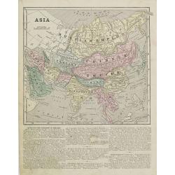
Asia.
Map of Asia encompassing the Russian Empire, the Chinese Empire, India Persia, Tartary, Turkey, and Arabia. From Sidney E. Morse''s: System of Geography for the use of sc...
Date: New York, 1855
North Pacific Ocean LOO CHOO and adjacent Islands 1855.
Large scale chart of Okinawa in the Japan Sea. With scale and vignette of Typographical office. Map nr. 2416.An interesting note in lower right "The coast line of al...
- $300 / ≈ €262
Date: London, 1855
Issidori mansiones parthicae a seleucia ad Alexandropolin archosiae.
Map showing Iran and the southern tip of the Caspian Sea. Published in 1855 by Karl Müller as part of his work "Geographi Graeci Minores".Muller wrote in Latin...
- $35 / ≈ €31
Date: Paris, Ambrosio Firmin Didot, 1855
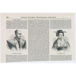
Japanese Sketches.
Two woodcut engravings illustrating a Japanese Gentleman and a Japanese Lady. Included in Ballou's Pictorial.The 1840s~50s saw the rapid growth in popularity of the illus...
- $25 / ≈ €22
Date: Boston, 1856
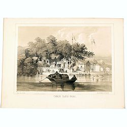
Chinese Temple, Macao.
A pleasant view of the important Chinese Temple in Macao, taken from the water with a junk in the foreground and many sampans and junks moored in front of it, with visito...
- $75 / ≈ €66
Date: Philadelphia, 1856
Napha from the Sea.
Decorative lithograph W. Heine and published by P. S. Duval & Co. From Commodore Matthew C. Perry's "Narrative of an Expedition of an American Squadron to the C...
Date: New York, 1856
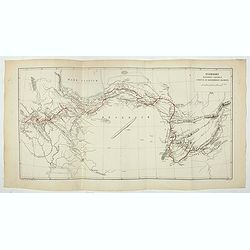
Chart showing the track of the Flagships of the US-Japan Expedition to the eastward of the Cape of Good Hope 1853 & 1854.
A simple sea chart showing the track of the US Steam Frigate Mississippi as she tracked her way from east of Cape Town across the Indian Ocean and the Bay of Bengal, up t...
- $50 / ≈ €44
Date: New York, 1857
The Caspian Sea, Khivah, and the surrounding country compiled from the best sources by John Arrowsmith
This is a very detailed map of the Caspian Sea regions to the north and east. It includes the Caspian Sea, Aral Sea, and the khanate of Khiva, including parts of today's ...
- $450 / ≈ €393
Date: London, 1846-1858
Giudea (Tav I)
A large-format map of the Holy Land with its dioceses. The map is finely engraved and beautifully colored and was prepared by Girolamo Petri, a lawyer who served as a sen...
- $600 / ≈ €524
Date: Rome, 1858
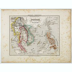
L'Indocina India Transgangetica e le Isole Filippine.
Uncommon map of part of Indo China and the Philippines prepared by Francesco Costantino Marmocchi. Above the map "Geografia Commerciale". From "Il Globo At...
Date: Genova, Paolo Rivara fu Giacomo, 1858
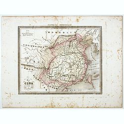
La Cina propriamente detta e sue isole.
Uncommon map of China prepared by Francesco Costantino Marmocchi. Above the map "Geografia Commerciale". From "Il Globo Atlante di carte Geografiche compil...
Date: Genova, Paolo Rivara fu Giacomo, 1858
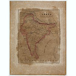
L'India e L'Isola di Seilan.
Uncommon map of India prepared by Francesco Costantino Marmocchi. Above the map "Geografia Commerciale". From "Il Globo Atlante di carte Geografiche compil...
Date: Genova, Paolo Rivara fu Giacomo, 1858
China, Sheet IX, Yang-Tse-Kiang from the sea to Nanking . . .
A fine, large-scale chart. This chart depicts the last stretch of the Yangtse River before it meets the sea. It gives soundings and notes on the tides, and includes an in...
- $750 / ≈ €655
Date: London, 1843-1859
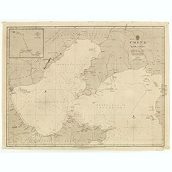
China east coast Yellow Sea and Gulf of Pechili
Very detailed chart of China's east coast with the Yellow Sea and Gulf of Pechili. Scale: circa 1:1m. Inscription: J & C Walker sculpt. One inset: Pekin to the Gulf o...
- $450 / ≈ €393
Date: London, 1840 - 1859

Vicariati E prefetture apostoliche nelle Indie Orientalis
Map showing the boundaries of Catholic dioceses in South and Southeast Asia in 1850s, with some detail of India, Malacca, Thailand and Hainan. This finely engraved and be...
- $500 / ≈ €437
Date: Rome, 1858-1859
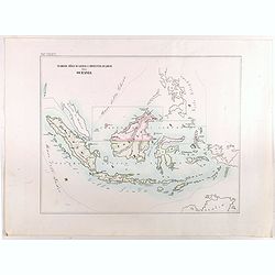
Vicariato aplico di Bataviaa E prefettura di Labuan nella Oceania.
Map showing the boundaries of Catholic dioceses in Southeast Asia in 1850s, with some detail of Java, Borneo, Sumatra. Including the Philippines, but without detail. This...
- $1000 / ≈ €874
Date: Rome, 1858-1859
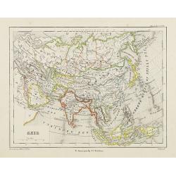
Azie.
Uncommon map of Asia. Lithography by J.H. van Weijer, published in Atlas der geheele Aarde [...] in 24 kaarten.
Date: Groningen, ca. 1860
Portions of the Russian Empire in eastern & western Asia.
Two maps on one sheet. Components: The Aral Sea according to Khanikoff -- Kamchatka according to A. Erman. Relief is shown by hachures and spot heights. No. 8 from Fullar...
- $200 / ≈ €175
Date: London, 1860
BATAVIA. Het post etablissement te Weltevreden. L'établissement des postes à Weltevreden.
Rare lithographed view of the post office at Weltevreden (Jakarta). Beautiful lithography drawn by Charles Th. Deeleman (1823 - 1884), lithographed by G.J. Bos and printe...
Date: Batavia, 1859-1860
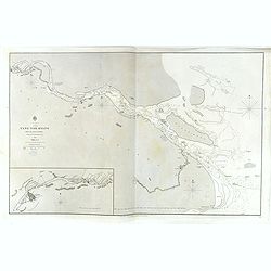
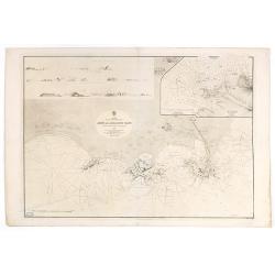
Carte de la Mer Noire. (5e Feuille). Du Cap Zefiros au Cap Kerempeh. . .
Very detailed chart of the Turkish part of the Black Sea including the towns of Sinop, Samsun, etc. Showing soundings in meters, lighthouses are marked with yellow and re...
Date: Paris, 1860
Asia Centrale, Tibet Thian - Scian - Nan - Lu, Mongolia Grand Deserto &.
From the "Geografia Commerciale". Steel engraving with attractive original outline color, printed on thick paper with wide margins. Engraved by C. Magrini.
Date: Genova, 1860
Specialkarte der Asiatischen Turkey : 1. Blatt Anadoli (Klein - Asien)
Steel engraved map of western part of Turkey, engraved by Ifslieb and J. Grassl.
- $75 / ≈ €66
Date: Hildburghausen, 1860
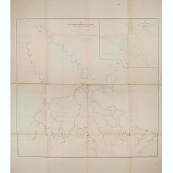
Plan de la rivierè de Saigon et de ses affluents dressé par ordre de M. le capitaine de vaisseau d'Ariès, gouverneur de Saigon, d'après les documents fournis par MM. Lespès. . .
A huge folded map the Saigon river prepared after Léo de Lespès, Rieunier Narac. Inset map of "Carte de Banc de Corail, levée d' après les ordres de Mr. le Capta...
- $750 / ≈ €655
Date: St Joseph, Saigon, after 1860

Europish Turkije, Griekenland Jonische Eilander.
Uncommon map of Greece, Lithography by J.H. van Weijer, published in Atlas der geheele Aarde in 24 kaarten. With colored key to processions.
- $10 / ≈ €9
Date: Groningen, ca. 1860
Militairy manuscript map of the end of Yangzi River across Shanghai, Jiangsu, and Zhejiang areas, with 3 red seals of the Ever-Victorious Army.
In the lower left corner, an inset plan of Songjiang District with Shanghai is shown with a grid, and the area is divided with red dotted border lines.The map has three r...
Date: China, ca 1862
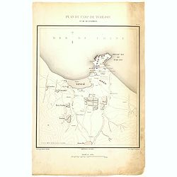
Plan de Camp de Tché-Fou et de ses environs.
A rare and detailed plan of Chefoo, which was a treaty port in Shantung province, near today's Yantai. Plate IV from "Atlas de l'expédition de Chine en 1860: rédig...
- $300 / ≈ €262
Date: Paris, 1862
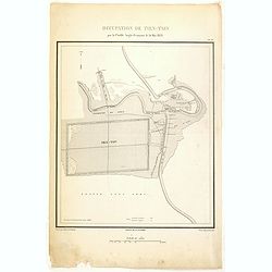
Occupation de Tien-Tsin par la Flottille Anglo-Française le 26 Mai 1859.
Plate III from "Atlas de l'expédition de Chine en 1860: rédigé au dépôt de la guerre d'après les documents officiels, étant directeur le général Blondel, so...
- $250 / ≈ €218
Date: Paris, 1862
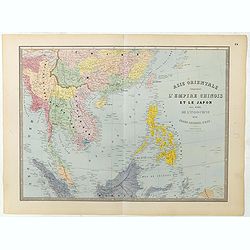
Carte de l'Asie orientale comprenant l'empire chinois le Japon les états de l'Indo-Chine et le grand archipel d'Asie ou Malaisie.
Detailed map of Malaysia, Thailand, China, Taiwan, and good detail in Philippines. Lower part of a 2-sheet map.
Date: Paris, 1862
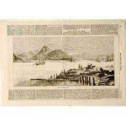
View of Nagasaki, Japan.
A panoramic view of Nagasaki harbour from the Illustrated Times of November 28th., 1863. With accompanying one column descriptive text on verso of Nagasaki.
- $100 / ≈ €87
Date: London, 1863
Küstenansichten von Japan bis Capstadt und St. Helena in 5 Blättern.
Prepared by Officer S.M.S. Arcona during the German expedition of 1860-1861 to South East Asia. Lithographed by Lippold and printed by C.Ulrich of Berlin. Sheet 2 from a ...
Date: Berlin, 1863
Az Europai és Asiai Torok Birodalom Kozonséges Foldképe
Hungarian map of Turkey, including Greece, Cyprus, etc.
- $150 / ≈ €131
Date: Pesten, 1864
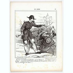
En Chine.
From the series "Caricatures du Prussien - Guerre des Duchés". Lithographed by Julés Pelcoq.
Date: Paris, 1864
Attaque & prise des forts du Pei-Ho Le 21 Août 1860, par les troupes Françaises et Anglaises.
In 1860, an Anglo-French force gathered at Hong Kong and then carried out a landing at Pei Tang on August 1, and a successful assault on the Taku Forts on August 21.This ...
- $500 / ≈ €437
Date: Paris, ca.1865
![(2 charts of Shri Lanka) Mer des Indes - Ile de Ceylan - Partie Nord. Détroit de Palk et Golfe de Manaar.. [with] Partrie Sud...](/uploads/cache/23493-250x250.jpg)
(2 charts of Shri Lanka) Mer des Indes - Ile de Ceylan - Partie Nord. Détroit de Palk et Golfe de Manaar.. [with] Partrie Sud...
Two very large charts representing the northern and southern part of Sri Lanka and giving details about the Indian seacoast around the Gulf of Mannar and the Palk Strait....
- $750 / ≈ €655
Date: Paris, 1866
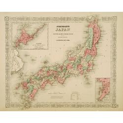
Johnson's Japan Nippon, Kiusiu, Sikok, Yesso. . .
A detailed steel-engraved map of Japan with inset maps of Yes and the Japanese Kuriles and Bay of Nagasaki. The map shows the island Argonaut labeled as Takashima (Ulleun...
- $175 / ≈ €153
Date: New York, 1867
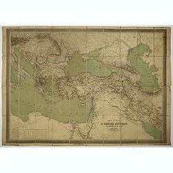
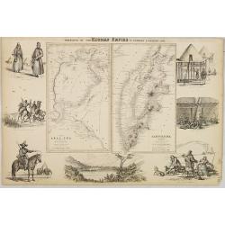
Carte général de L'Empire Ottoman en Europe et en Asie. . . dressée par Henri Kiepert.
Large School wall map of Turkish Empire printed in chromo-lithography. Published by Dieter Reimer and printed by Ferdind Barth in Berlin.This rare map has two insets in l...
- $700 / ≈ €611
Date: Berlin, Dieter Reimer, 1867
Arabia. Gulf of Aden - North Coast. Aden and Adjacent Bays..
Large chart focused east of Aden, in Yemen. With inset plan of Aden Anchorage in the upper right corner and a set of coastal profiles in the upper left corner.With latitu...
- $900 / ≈ €786
Date: London (1836) corrected to 1868

Carte générale de la mer des Indes dressée par P. Daussy et P.E. Wissocq, grave par Chassant, ecrit par J.M. Hacq.
Magnificent and detailed large-scale chartdepicting the Indian ocean, with east coast of Africa, Madagascar, Arabian Peninsula, India, China, etc .Including the West coa...
- $1000 / ≈ €874
Date: Paris, 1837-1869
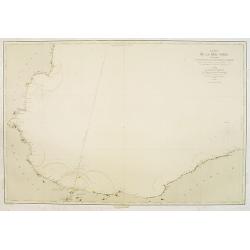
Carte de la Mer Noire. (1e Feuille). Du Bosphore à Mangalia et du Bosphore au Cap Kerempeh.
Very detailed chart of the Turkish part of the Black Sea including the towns of Constantinople (Istanbul) , Bourgas. Showing soundings in meters, lighthouses are marked w...
Date: Paris, 1860, updated for 1870
![Veduta di Istambul. [Gouache]](/uploads/cache/45368-250x250.jpg)
Veduta di Istambul. [Gouache]
Very decorative view depicting Istanbul, in the style of Neapolitan gouaches. Features different Mosques and the shores of the Bosporus. Many ships, small and large, are ...
Date: Italy ?, ca. 1870
![Bay of Bengal, compiled chiefly from government survey.. [2 sheets]](/uploads/cache/23495-250x250.jpg)
Bay of Bengal, compiled chiefly from government survey.. [2 sheets]
Large scale chart in 2 sheets focused on the Bay of Bengal.It covers Sri Lanka, the whole Indian eastern coast, the seacoast of Bangladesh, Myanmar and Thailand as far as...
- $1200 / ≈ €1048
Date: London (1863), corrections to 1871
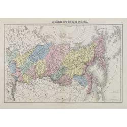
Sibérie ou Russie d'Asie.
A decorative map of Siberia from Géographie Universelle, Atlas Migeon. published by J. Migeon.From one of the last decorative atlases published in the 19th century.
Date: Paris, 1874
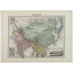
Inde, Chine, Indo-Chine et Japon.
A decorative map of India, China, Japan and East Asia from Géographie Universelle, Atlas Migeon, published by J. Migeon. In lower right corner a view of Calcutta and to ...
Date: Paris, 1874
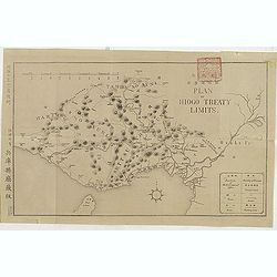
(Plan of Hiogo Treaty Limits)
Map of the new prefecture with Japanese and English descriptions. In lower right an key to "Position of Government Office, boundaries, road and railways. On January ...
Date: Meiji 10 = 1877
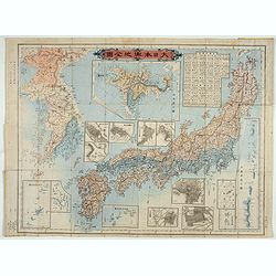
Kaisei dosen Dai Nihon yochi zenzu.
Title in top : "Dai Nihon yochi zenzu.". Showing Japan, Korea and in an inset Hokkaido. Folding copperplate print in Japanese. Relief shown by hachures. Include...
- $350 / ≈ €306
Date: Tokyo, Meiji 10 or 1877
Karte des Türkischen Reiches in Europa und Asien . . .
Map of Turkish Empire.
- $35 / ≈ €31
Date: Breslau, 1878
![[Constantinople]](/uploads/cache/46659-250x250.jpg)
[Constantinople]
The lower half only of a larger map titled 'Turkey Central Mediterranean Regions' by Archibald Fullarton, published in his The Royal Illustrated Atlas of Modern Geography...
Date: London, Edinburgh, 1879
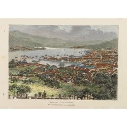
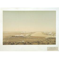
Nagasaki. - Vue générale. Dessin de Taylor, après une photographie.
A bird's-eye view showing Nagasaki Bay. After a photograph by Taylor. Engraved in wood by A.Kohl.Showing the town and natural harbour of Nagasaki.In the harbour the islan...
- $150 / ≈ €131
Date: Paris, 1880
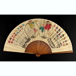
A folding fan with a map of Japan, double hemisphere world map and views of Yokohama and Edo.
The folding fan showing a map of Japan on one side, and on the other side a double hemisphere world map, two city views, and a train. Read more about folding fans andcar...
- $750 / ≈ €655
Date: Japan, ca. 1880
