Browse Listings in Asia > Korea (and Japan)
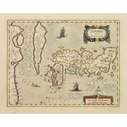
Japoniae Nova Descriptio.
The map is identical in cartographic detail to the Hondius map of 1606 but newly designed ornate cartouches have been added. The three main islands of Japan are shown wit...
Date: Amsterdam 1650
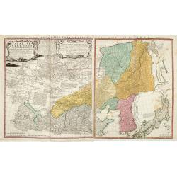
Tartariae Sinensis mappa geographica ex Tabulis specialibus RRPP Iesuitarun nec non Relationibus R.P. Gerbillon / per Dom d'Anville, . . . primum A° 1732 nunc se Nunc secundum LL. projectionis . . . descripta per Tobiam Mayer
A very attractive map of Korea and Manchuria on the mainland and two islands of 'Ezo' and Sakhalin, prepared by Jean-Baptiste Bourguignon d'Anville (1697-1782) and Johann...
- $750 / ≈ €655
Date: Nuremberg, 1749
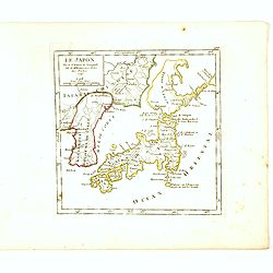
Le Japon Par le Sr. Robert de Vaugondy fils de Mr. Robert Geog. Ord du Roi avec Privilege 1749.
Small detailed map of Japan and Korea. From Atlas Portatif Universel, by Robert de Vaugondy.Page 168 outside border top right. First state. The map is of interest for the...
Date: Paris, 1749
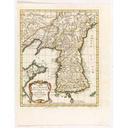
Carte de la province de Quan-tong, ou Lyau-tong et du Royaume de Kau-li ou Corée.
Map of Korea. The map is of interest for the use of East Sea, the sea between Korea and Japan, here called "Mer de Corée. With Seoul named, King-Ki-TaoDecorative ti...
Date: Paris, 1757
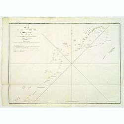
Plan de la partie des iles, ou archipel de Coree, vue au mois de Mai 1787 par les Fregates Francaises la Boussole et l'Astrolabe. . . .
Showing the track of La Pérouse along the southern most tip of Korea, with Quelpaerts Islands (now-a-days called Jeju, with the vulcano Halla-san (Halla Mountain) clearl...
- $400 / ≈ €349
Date: L'Imprimerie de la Republique, An V, 1797
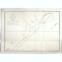
Plan de la partie des iles, ou archipel de Coree, vue au mois de Mai 1787 par les Fregates Francaises la Boussole et l'Astrolabe. . . .
Showing the track of La Perouse along the southernmost tip of Korea, with Quelpaerts Islands (nowadays called Jeju, with the volcano Halla-san (Halla Mountain) clearly no...
- $450 / ≈ €393
Date: L'Imprimerie de la Republique, An V, 1797
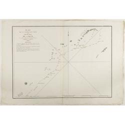
Plan de la partie des Isles ou Archipel de Corée.
Showing the track of La Perouse along the southern most tip of Korea, with Quelpaerts Islands (now-a-days called Jeju, with the volcano Halla-san (Halla Mountain) clearly...
Date: Paris, 1797
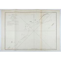
Plan de la partie des Isles ou Archipel de Coree.
Showing the track of La Perouse along the southernmost tip of Korea, with Quelpaerts Islands (nowadays called Jeju, with the vulcano Halla-san (Halla Mountain) is clearly...
Date: Paris, 1797
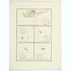
Plan de la partie de l'ile de quelpaert. . . / Plan de l'ile Hoapinsu. . . / Plan de l'ile Dagelet. . . / Plan de la partie de l'ile de Botol. . . / Plan de l'ile de Kumi. . .
Five plans on a folio sheet. These charts include Cheju Do, Korea (Quelpaert Is.), Kume-Shiwa, Okinawa (Kumi), and Ullung Do (Dagelet).Including one of the earliest maps ...
Date: Paris, 1797
![Part of the island of Quelpart seen 21 may 1787. . . [5 maps on one sheet]](/uploads/cache/29902-250x250.jpg)
Part of the island of Quelpart seen 21 may 1787. . . [5 maps on one sheet]
Detailed maps of islands south of Korea. Of interest is the inset map of L'ile Dagelet (The Isle of Dagelet), the note in French says "Discovered by the French friga...
- $300 / ≈ €262
Date: London, G. G. & J. Robinson, Paternoster Row, London, 1798
![[Views of Korea, Thailand, Cambodia and its inhabitants and princes. Including one or more phographes by Hippolyte Frandin.]](/uploads/cache/48426-250x250.jpg)
[Views of Korea, Thailand, Cambodia and its inhabitants and princes. Including one or more phographes by Hippolyte Frandin.]
A collection of 95 photographs, of which about 60 photos feature Korea or its people, printed on albumen paper. Captions in French. The others from Thailand, China, India...
- $25000 / ≈ €21839
Date: C. 1892
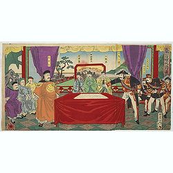
Chosen Danpan (Discussing the clauses of the ultimatum between the Japanese, Chinese and Korean forces).
Japanese woodcut showing the Japanese, Chinese and Koreans discussing the clauses of the ultimatum between Japan, China and Korea, . Yôsai Nobukazu (1872-1944).A scene...
- $1200 / ≈ €1048
Date: August 8, MEIJI 27th year or 1894
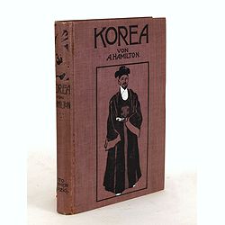
Korea. Das Land des Morgenrots. Nach seinen Reisen geschildert von Angus Hamilton. Autorisierte Übersetzung aus dem Englischen.
With 114 illustrations after photographes and one map.
- $175 / ≈ €153
Date: Leipzig: Spamer, 1904
