Browse Listings in Asia

Festivals of India.
A large eye-catching poster of five women, dancing against a black background, dressed in stunning sari's of red, yellow and blue, produced in India by the Government, wi...
- $750 / ≈ €638
Date: Calcutta, 1959

Balinees watercolor on paper, fisherman.
Decorative export painting from Bali of a more than average quality.
- $150 / ≈ €128
Date: Bali, ca 1960

Balinees watercolor on paper, fishermen.
Decorative export painting from Bali of a more than average quality.
Date: Bali, ca 1960

Balinees watercolor on paper, fishermen.
Decorative export painting from Bali of a more than average quality.
- $150 / ≈ €128
Date: Bali, ca 1960
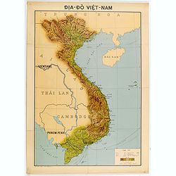
Dia-Do Viet-Nam.
Economic map of Vietnam published in 1960 (not for sale), gift from Japan paper committee. Scale : 1:2 400 000. With a key at lower right part.Features Vietnam, Cambodia,...
Date: 1960
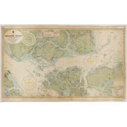
China Sea - Singapore Strait principally from British Admirality
An exceptionally nautical British Admiralty nautical chart of Singapore and direct vicinity. Centered Singapore city and the narrow strait between Singapore Island and Pu...
Date: Admirality, London, [1865-1960] updated 1960
![[US Army map of a part of Vietnam.]](/uploads/cache/44790-250x250.jpg)
[US Army map of a part of Vietnam.]
A large aerial US Army map of a portion of Vietnam, taken during the war between the two countries. As you might expect the map is highly detailed, highlighting settlemen...
- $150 / ≈ €128
Date: Washington D.C., 1967
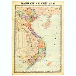
Hành Chính Việt Nam.
Uncommon map of Vietnam published in 1976, one year after the end of the Vietnam War. In April 1976, the National Assembly decided to reiterate Hanoi as the capital of th...
Date: Hanoï, 1976
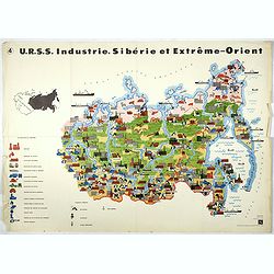
U.R.S.S. Industrie. Sibérie et Extreme-Orient. (4)
Map of Siberia. Propaganda poster for Russia's in and export of industrial goods from Siberia. Editions de l'Agence de presse Novosti".More about War Maps & Prop...
- $150 / ≈ €128
Date: USSR, 1978
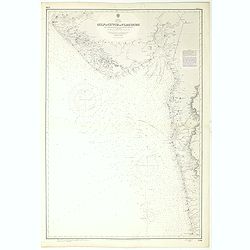
India west coast Gulf of Cutch to Vijaydurg . . .
Chart of India's west coast map surveyed by the hydrographer Captain JF Parry. A highly corrected version of Admiralty chart 2736 originally published 1st July 1915. Date...
- $200 / ≈ €170
Date: London, 1915-1980

Anamu Buru to Latakia including Iskenderun Körfezi.
A highly corrected version of Admiralty chart 2632 originally published 25 November 1955 under the Superintendence of Captain K.SB. Collins. Edition Date 1984 Detailed ch...
- $100 / ≈ €85
Date: London, 1955 - 1984
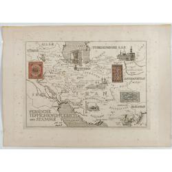
Persische Teppichknüpfgebiete und Stämme.
Map of Iran and neighboring countries in German language, published in limited edition probably in France : "Gravée à l'eau-forte et au burin. Edition limitée&quo...
Date: France ?, after 1935 - before 1991
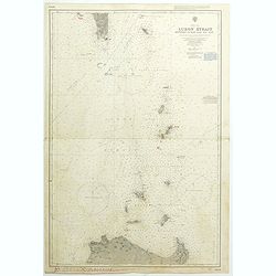
China Sea Luzon Strait between Luzon and Tai-Wan from the United States & Japanese Government chartsto 1929. . . (3804)
A highly corrected version of Admiralty chart 3804 originally published 18 September 1925 under the Superintendence of Captain P.H. Douglas. New Editions 18th December 19...
- $150 / ≈ €128
Date: London, 1929 / 1992
China sea Gulf of Tongking (Southern sheet).
A highly corrected version of Admiralty chart 3989 originally published 11 Mai 1962 under the Superintendence of Captain EG Irving. Detailed chart including the coasts of...
- $80 / ≈ €68
Date: London, 1962 - 1992
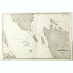
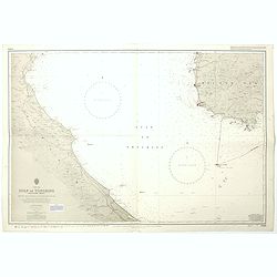
China Sea Philippine Islands - San Bernandino Strait and approaches. (3370)
A highly corrected version of Admiralty chart 3370 originally published 14th November 1924 under the Superintendence of Captain H.P. Douglas. Edition Date 1982 with furth...
- $150 / ≈ €128
Date: London, 1924 / 1996

Philippine Islands - Semirara, Ilin and Ambulong 1.s with part of Mindoro. (971)
A highly corrected version of Admiralty chart 971 originally published 15th February 1866 under the Superintendence of Captain G.H. Richards. Edition Date 1991 with furth...
- $150 / ≈ €128
Date: London, 1866 / 1999

Philippine Islands - Mindanao West Coast - Basilan Strait to Camiguin Island including Tubbataha Reefs. . . (3811)
A highly corrected version of this oversized Admiralty chart 3811 originally published 26th February 1925 under the Superintendence of Captain P.H. Douglas. Edition Date ...
- $150 / ≈ €128
Date: London, 1925 / 2005

