Browse Listings in Asia > Philippines
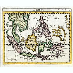
L'india.
This small Italian map of of South East Asia, with Indonesia, , Malacca is based on the cartography of Guillaume Delisle. Japan is shown attached to Ter di Yesso (Hokkai...
Date: Venice, c.1722
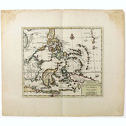
Nieuwe kaart van de Filippynsche, Ladrones, Moluccos of Specery Eilanden als mede Celebes etc.
Shows the western islands of the archipelago, Borneo, Java and Sumatra, up to and including New Guinea. With very good detail to Philippines.Read more Early maps of South...
Date: Amsterdam, 1740
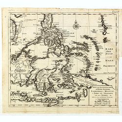
Nuova et Accurata Carta dell' Isole Filippine, Ladrones, a Moluccos o Isole della Speziarie come anco Celebes &c.
The map has been prepared by Isaac Tirion for his Nieuwe en beknopte Handatlas (New and concise hand-atlas) of which Albrizzi made an imitation and used in the Italian ed...
- $400 / ≈ €349
Date: Venice, 1740-1762
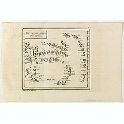
Karte von den neuen philippinen.
Small map of the southern Philippines. In: "Allgemeine Historie der Reisen zur Wasser und zu Lande: oder Sammlung aller Reisebeschreibungen.. in Englischen zusammen ...
- $200 / ≈ €175
Date: Leipzig, Arkstee und Merkus, 1764
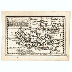
East India Islands
Good detail on Philippines. Uncommon miniature map from Gibson's "Atlas Minimus, or a New Set of Pocket Maps of the several Empires, Kingdoms and States of the known...
- $150 / ≈ €131
Date: London, 1792
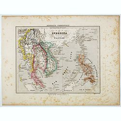
L'Indocina India Transgangetica e le Isole Filippine.
Uncommon map of part of Indo China and the Philippines prepared by Francesco Costantino Marmocchi. Above the map "Geografia Commerciale". From "Il Globo At...
Date: Genova, Paolo Rivara fu Giacomo, 1858
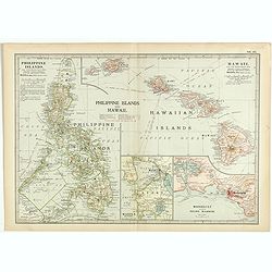
Philippine Islands and Hawaii.
Map of Philippine Islands and Hawaii, with inset maps of Manila, Honolulu, and Pearl Harbor, circa 1902, from the 10th edition of Encyclopaedia Britannica.
- $40 / ≈ €35
Date: London, ca. 1902
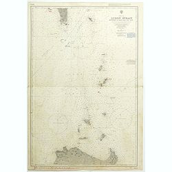
China Sea Luzon Strait between Luzon and Tai-Wan from the United States & Japanese Government chartsto 1929. . . (3804)
A highly corrected version of Admiralty chart 3804 originally published 18 September 1925 under the Superintendence of Captain P.H. Douglas. New Editions 18th December 19...
- $150 / ≈ €131
Date: London, 1929 / 1992
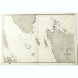
China Sea Philippine Islands - San Bernandino Strait and approaches. (3370)
A highly corrected version of Admiralty chart 3370 originally published 14th November 1924 under the Superintendence of Captain H.P. Douglas. Edition Date 1982 with furth...
- $150 / ≈ €131
Date: London, 1924 / 1996

Philippine Islands - Semirara, Ilin and Ambulong 1.s with part of Mindoro. (971)
A highly corrected version of Admiralty chart 971 originally published 15th February 1866 under the Superintendence of Captain G.H. Richards. Edition Date 1991 with furth...
- $150 / ≈ €131
Date: London, 1866 / 1999

Philippine Islands - Mindanao West Coast - Basilan Strait to Camiguin Island including Tubbataha Reefs. . . (3811)
A highly corrected version of this oversized Admiralty chart 3811 originally published 26th February 1925 under the Superintendence of Captain P.H. Douglas. Edition Date ...
- $150 / ≈ €131
Date: London, 1925 / 2005
