![Septima Asie Tabvla. |Walsseemüller's map of Central Asia and the Silk Road]](/uploads/cache/62137-250x250.jpg)
Septima Asie Tabvla. |Walsseemüller's map of Central Asia and the Silk Road]
Trapezoidal woodcut map showing the area east of the Sarygamysh Lake, about midway between the Caspian Sea and the (former) Aral Sea. It is one of the earliest obtainabl...
Date: Strasburg, J. Schott, 1513
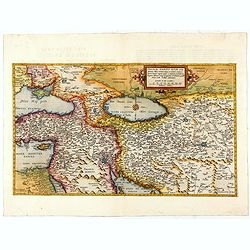
Primae Partis Asiae.
The Very Rare First State. Turkey/ Holy Land/ Iran/ Iraq/ Arabia/ Afghanistan. A superb example of the rare 1578 edition of this fine map of the Middle East, spanning fro...
- $4500 / ≈ €3931
Date: Antwerp, 1578
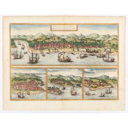
Calechut / Ormus / Canonor.
Four panoramic on one sheet: the upper approximately two-thirds of this double page sheet contains a fine panoramic view of Calicut which is on the west coast of India i...
Date: Cologne, 1580
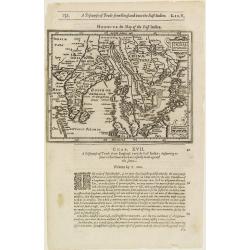
India Orientalis.
The rare Samuel Purchas' edition of the Mercator/Hondius Atlas Minor atlas map. Thisearly map of the East Indies was published in his famous collection of voyages His Pil...
- $300 / ≈ €262
Date: London, 1625
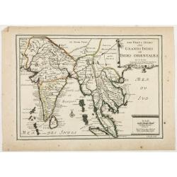
Les Vrays Indes dits Grandes Indes ou Indes Orientales Par N. de Fer. Geographe de Sa Majeste Catoliques et de Monseigneur le Dauphin.
Detailed map on India, Thailand, the Malay Peninsular and the south coast of China up to Macao. The map was engraved by C. Inselin.
Date: Paris, 1703
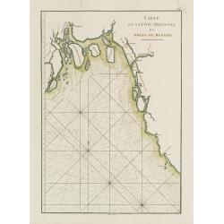
Carte de la Côte Orientale du Golfe du Bengale.
French sea chart of coast northeast of India. Latitude and longitude scales, compass rose and system of rhumb lines, soundings near coast and in bay areas.D' Après de Ma...
- $150 / ≈ €131
Date: Paris, ca 1775
Turchia Nell' Asia antica, e moderna.
Rare map of Armenia, Palestine, Turkey and northern Arabia, from "Atlante Novissimo ad uso Dei Giovani Studiosi Contenuto In Carte XXVII.", published by Giovann...
- $200 / ≈ €175
Date: Rome, 1780
![[Abiti de' tibetani].](/uploads/cache/34999-250x250.jpg)
[Abiti de' tibetani].
Aquatint depicting a group of Tibetans, in the early 1800s. Plate N°8.From Giulio Ferrario's work Le Costume Ancien et Moderne ou Histoire du gouvernement, de la milice,...
- $100 / ≈ €87
Date: Milan, 1827
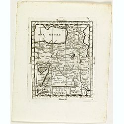
Issidori mansiones parthicae a seleucia ad Alexandropolin archosiae.
Map showing Iran and the southern tip of the Caspian Sea. Published in 1855 by Karl Müller as part of his work "Geographi Graeci Minores".Muller wrote in Latin...
- $35 / ≈ €31
Date: Paris, Ambrosio Firmin Didot, 1855
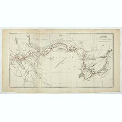
The Caspian Sea, Khivah, and the surrounding country compiled from the best sources by John Arrowsmith
This is a very detailed map of the Caspian Sea regions to the north and east. It includes the Caspian Sea, Aral Sea, and the khanate of Khiva, including parts of today's ...
- $450 / ≈ €393
Date: London, 1846-1858
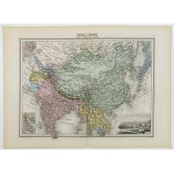
Inde, Chine, Indo-Chine et Japon.
A decorative map of India, China, Japan and East Asia from Géographie Universelle, Atlas Migeon, published by J. Migeon. In lower right corner a view of Calcutta and to ...
Date: Paris, 1874
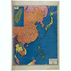
![[Escape map] N°34 Southeast Asia + Northeast Asia.](/uploads/cache/40293-250x250.jpg)
[Escape map] N°34 Southeast Asia + Northeast Asia.
A fine "survival map" or "escape map" of China was compiled for the U.S. Army Air Forces. South China side has an inset of Taiwan (Formosa). These lig...
- $125 / ≈ €109
Date: Washington, D.C. 1944
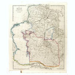
Political Map of Asiatic Coastal Area.
A strongly colored, large map of the Asiatic Coastal countries. All countries are color coded. Maps coverage is from China and Japan in the north, south to the tips of Su...
- $450 / ≈ €393
Date: Chicago, ca 1952
