Browse Listings in Map Types

Citta, porto, e rada di Brest, e . . . Nella Bretagna . . .
A beautiful and rare map of Bretagne. In top right an inset with the town of Brest.The remarkable Vincenzo Coronelli (1650-1718), encyclopaedist, geographer, inventor and...
Date: Venice, 1690

Carte de la Manche. . .
Decorative chart showing the Chanel, with the coastline of France from La Baie de Douarnenez to Dunkerque, and the coastline of England from Stroble head to Manning Tree....
Date: Amsterdam, 1692

Plan de la ville, cite universite et fauxbourgs de Paris comme il est jourddhuy. . .
Detailed town-plan of Paris.Top left and bottom right and left cartouches decorated with views of the top left, Notre Dame, Palace of Orleans, Sorbonne and Val de Grâce,...
Date: Paris, 1694

A plat of the East Sea. By William Fisher and Richard Mount...
An important sea chart of the East Sea with coast lines of Poland, Russia, Sweden, published by William Fisher and Richard Mount in London.Richard Mount (1654-1722) was a...
Date: London, 1695
![[Title page] Atlas Nouveau contenant toutes les parties du monde . . .](/uploads/cache/49114-250x250.jpg)
[Title page] Atlas Nouveau contenant toutes les parties du monde . . .
Fine title page of classical architectural design incorporating portraits of royalty and battle scenes.
Date: Paris, 1696

Launa vulgo Laun Bohemiae civitas.
Bird's-eye views of Louny in Bohemia by G. Hoefnagel. The copperplate was made for Braun and Hogenberg's town book. However there the print has been transformed by the en...
Date: The Hague, 1700
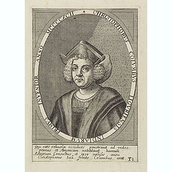
Christophorus Columbus Liguriensis Indiarum Primus Inventor Anno MCCCCXCII.
Portrait of Christopher Columbus (c. 31 October 1451 – 20 May 1506), explorer, colonizer, and navigator, born in the Republic of Genoa, in north-western Italy. Under th...
Date: Antwerp, c.1700
Selling price: ????
Please login to see price!
Sold in 2023

II Regno di Francia Diviso in Provincie e Governi ove su`Le Frontiere di esso Rappresenta il Teatro della Guerre di Flandria Germania Savoja e Lombardia.
Very rare wall map of France depicting "The Kingdom of France divided into Provinces and Governments with on its borders the Theater of War of Flanders, Germany, Sav...
Date: Naples, 1704
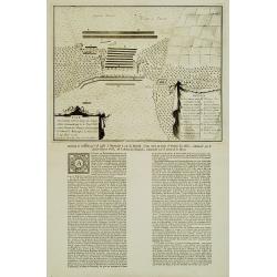
Plan De l'Action.. Auprès de Wynendale le 28 Sept. 1708.
A rare broadside sheet represents a conventional battle plan near the town of Torhout with the Castle Wynendale. The plan depicts the situation of 28 September 1708. Incl...
Date: Bruxelles, c.1708

Pas kaart vande Zuyd kust van Cuba en van Geheel Jamaica…
A nautical chart covers the southern part of Cuba, Jamaica, the western tip of Hispaniola, and some Honduran coastline. Insets of "Baya Oristan in Yamaica ent Groodt...
Date: Amsterdam, J. van Keulen, 1697-1709

Nansenbushu bankoku shoka no zu.
This wall-map is a great example of Japanese world maps representing Buddhist cosmology with real-world cartography. It is the earliest one and - therefore - the prototyp...
Date: Kyoto, (Hoei 7 = Year of the Tiger) 1710

.Paskaart van de Mont van de Witte Zee,. Beginnende van Tiepena tot Pelitza, als mede van C. Cindenoes tot Catsnoes.
Fine sea chart of the southern part of the Barents Sea, oriented to the West. With five inset maps: - Swetenoes, de Kust van Laplandt, Lombascho, 'T Vaste Landt van Lapla...
Date: Amsterdam, c.1710

De golf van Bengalen.
Rare chart of the Indian Ocean, with nice detail on Ceylon (Sri Lanka) with compass roses and a system of rhumb lines, soundings and anchorage's. Many place names. The pl...
Date: Amsterdam, after 1669-1712
![[Title page] Le Nouveau Theatre du Monde.](/uploads/cache/47951-250x250.jpg)
[Title page] Le Nouveau Theatre du Monde.
The fine engraved frontispiece by F. Bleiswyk entitled "Le Nouveau Theatre du Monde" for Pieter van der AA. Shows Atlas carrying the world on his shoulders acco...
Date: Leiden, 1713
![[Title page] La Sphere Royale.](/uploads/cache/48022-250x250.jpg)
[Title page] La Sphere Royale.
Title page from Nicolas de Fers "La Sphere Royale", published in 1717. Showing a sphere, surrounded by Neptune, Europe, the elements and scholars.
Date: Paris, 1717

Paldobundo Province.
Woodblock printed map of Jeolla Province which was one of the historical Eight Provinces of Korea during the Kingdom of The map is drawn in "Paldo Bundo," styl...
Date: 1710-1718
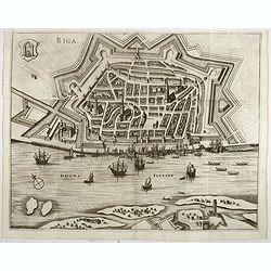
Riga.
Decorative view of Riga. This well executed engraving was published in 1729 and 1727 by Pieter van der AA, in Leiden in "Les Voyages tres-curieux et tres-renommez fa...
Date: Leiden, 1719

Carte des pavillons accompagnée d'observations pour en faire comprendre le blazon et les différentes devises aussy bien que d'une table alphabétique pour les trouver facilement.?
Map of 88 marine flags, including Malta, Turkey, Middelburg, Amsterdam, Portugal, Monaco, Tuscany, China, Nanking, the French Royal flag, French admiralty flag and mercha...
Date: Amsterdam, 1720
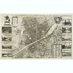
Florentia Pulcherrima et Ruriae Civitas.
Detailed bird's-eye view of the town of Florence in Tuscany region, first published in Frederick de Wit's rare town book. With two keys 1-17 and 1-228 to important spots ...
Date: Amsterdam, Leiden, 1697 / 1729

Colossus Monarchic. Statua Danielis
Fantastic double page allegorical map of a colossus figure representing the great world empires as Daniel interpreted in Nebuchadnezzar's dream. The warrior stands stolid...
Date: Augsbourg, 1730
![[Title page for ] Atlas Novus Terrarum orbis Imperia.](/uploads/cache/47938-250x250.jpg)
[Title page for ] Atlas Novus Terrarum orbis Imperia.
Title page from Atlas Novus printed by Johann Ernst Udelbulner. Large elaborately engraved sheet with numerous allegorical figures. A large globe, showing the Eastern Hem...
Date: Nuremberg, 1732
![[World and 4 continents] Carte Geographique Astronomique Chronologique et Historique du Monde.](/uploads/cache/63024-250x250.jpg)
[World and 4 continents] Carte Geographique Astronomique Chronologique et Historique du Monde.
French wall map of the world in 4 sheets published by Crépy "à l'entrée du Cloistre de St. Benoist du côté des maturins". A decorative wall map of the worl...
Date: Paris, 1720-1735

Urbium Londini et West-Monasterii nec non Surburbii Southwark Accurata Ichnographia ,., Neuester Grundris der Staedte London und West-Munster, Samt der Vorstadt Southwark ,.,
Detailed plan of London, extending from Grosvenor Square in the west to Mile End to the east, To the right inset views of St, James's Square, and Custom House, elevations...
Date: Nuremberg, 1736
![[Title page] Atlas Novus Terrarum Orbis Imperia. . .](/uploads/cache/49113-250x250.jpg)
[Title page] Atlas Novus Terrarum Orbis Imperia. . .
The lovely title page from Homann's Grosser Atlas uber de Gantsa Welt (Grand Atlas of all the World)with striking color and features. It shows Atlas and Hercules / Herakl...
Date: Nuremberg, ca 1737

Plan de Paris commencé l'année 1734, Dessiné et gravé sous les ordres de Messire Michel Etienne Turgot, prévost des marchands.
FIRST EDITION of Turgot's Monumental Joined View of Paris, stretching to over 10 Feet. This expansive large-scale engraved view of Paris covers the first eleven arrondis...
Date: Paris, 1739

Bern in der Schweitz.
Very fine large-scale panoramic view of Bern. With a numbered key (1-25) of principal buildings in town. ¤
Date: Augsburg, 1740

Paris.
A spectacular large-scale panoramic view of Paris, with legends numbered from 1-70 in French. With the title in a banderol.After a design by Friedrich Bernhard Werner (16...
Date: Augsburg, ca. 1740

Paris.
This is a spectacular panoramic view of Paris, with legends numbered from 1 to 70 in French. The title is in a banderol.After a design by Friedrich Bernhard Werner (1690-...
Date: Augsbourg, ca. 1740

Les Provinces confederées du Pais-Bas
The first wall map of the Seven Provinces of 1651, reissued as 'Stoel des Oorlogs' by Covens & Mortier. The first issue of the present wall-map is known to be include...
Date: Amsterdam, c. 1740
![[Portrait] Johannes Baptista Homann . . .](/uploads/cache/36599-250x250.jpg)
[Portrait] Johannes Baptista Homann . . .
Stunning full portrait of the Imperial Geographer of the Holy Roman Empire, Johann Baptist Homann (1664-1724) who was born in the Bavarian town of Kammlach. Educated at a...
Date: Nuremberg, c.1740
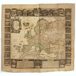
L'Europe Dressée Sur les Nouvelles observations. . .
A rare and monumental wall map of Europe, with original outline color, of four joined sheets, surrounded by text and vignettes printed on separate sheets.Created in 1740 ...
Date: Paris, 1700-1740
![[Title page] Atlas Minor Praecipua Orbis Terrarum Imperia, Regna et Provincias , Germaniae Potissimum. . .](/uploads/cache/48479-250x250.jpg)
[Title page] Atlas Minor Praecipua Orbis Terrarum Imperia, Regna et Provincias , Germaniae Potissimum. . .
An attractive and highly decorative title page to Seutter's Atlas Minor. Engraved by Martin Crophius after Jacob Weyerman. The engraving is packed with lively figures fro...
Date: Augsburg, 1744
![Carte de la coste orientale de la Chine depuis Amoy, jusqu'à Chusan avec une partie de l'Isle Formose [with] Plan du port d'Amoy ou Emouy.](/uploads/cache/33583-250x250.jpg)
Carte de la coste orientale de la Chine depuis Amoy, jusqu'à Chusan avec une partie de l'Isle Formose [with] Plan du port d'Amoy ou Emouy.
Important French chart of the China Sea with the coast of Northern China, including a large depiction of Formosa.Latitude and longitude scales, compass rose and system of...
Date: Paris, Jean-François Robustel, 1745

Nouvelle carte des mers comprises entre le détroit de Banca et P°. Timon avec la partie orientale du détroit de Malacca.
Important French chart of the tip of Malaysia with Singapore. Latitude and longitude scales, compass rose and system of rhumb lines, soundings near coast and in bay areas...
Date: Paris, 1745

Carte particulière de la côte d'Afrique depuis le cap des Courans jusqu'à la baye de Ste Hélène. . .
Large and detailed sea chart of South Africa.Engraved by Guillaume-Nicolas Delahaye (1727-1802).Latitude and longitude scales, compass rose and system of rhumb lines, sou...
Date: Paris, 1745
Tabula chronologica historiae Sinicae connexa cum cyclo qui vulgo Kia Tse dictur.
A set of two sheets of colored copper engravings. First published in 1729 in Rome in three sheets. Timeline of China's history with a chronological overview of the dynast...
Date: Augsburg, 1746
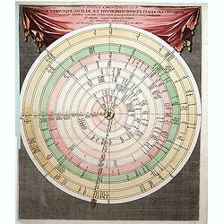
Discus Chronologicus Regum utriusque Siciliae et Ducum Princ
Chronological volvelle table showing the Sicilian rulers from the year 0 until 1730. COMPLETE with its volvelle. Each circle corresponds to a jurisdiction.
Date: Nuremberg, 1750

Amsterdam Ville du Comté de Hollande et la plus considerable des Provinces Unies. . .
A very decorative and extremely rare town-view of Amsterdam, including a numbered (1-18) key in lower part. Extensive shipping on the IJ. To the left the headquarters of ...
Date: Paris, ca.1750

Nieuwe en zeer accuraate Zee-Caart van de Hollandse Wal strekkende van de Maas tot Texel opgenomen door Jan Rokusz Douw, , ,
A very fine and rare chart of the coast of Holland, Prepared by Jan Rokusz, Douw and Agge Roskam Kool.Embellished with a very decorative cartouche with a dedicational tex...
Date: Amsterdam, 1750

D. Cassini. Né en 1625. mort en 1712.
Very rare stipple engraved portrait of Jean Dominique Cassini. Dominique Cassini was the son of César-François Cassini de Thury, the grandson of Jacques Cassini and the...
Date: Paris, ca. 1750

Nieuwe Wassende Graadige Pas-kaart van de Kust van Guinea en Brasilia.
Rare two-sheet sea chart of the coasts of Brazil, West Africa and South Africa, published by Johannes Van Keulen (the younger), circa 1720.The chart shows the western coa...
Date: Amsterdam, 1751

Vue et perspective de la ville de Marseille et ses environs, prise du côté de la belle vue de la plaine St. Michel. Dediée à S. A. S. Mgr. le duc de Penthievre Grand Amiral de France. Par son très humble et très obéissant Serviteur Aulagnier.
Scarce large and spectacular panorama of the city and harbour of Marseille published in Paris in the middle of the 18th century. Engraved by Pierre Jacques Duret under th...
Date: Paris, 1751

Nieuwe Wassende Graade Zee Kaart over de Spaanse Zee Vant Kanaal tot 't Eyland Cuba In Westindia.
Rare two-sheet blue-back sea chart of the Atlantic and Eastern part of North America., published by Gerard Van Keulen. The map extends from the latitude of Newfoundland a...
Date: Amsterdam, ca. 1728-1751

Pas-Kaat vaneen gedeelte van de Aethiopische Zee behelsende de Kusten Zanguebar, Ajan en Abex, en een gedeelte van de Arabische Kust. . .
A finely engraved and detailed chart of the most eastern tip of Africa, including Somalia, Djibouti, Yemen, Mauritius, and many other islands in the Indian Ocean.Very rar...
Date: Amsterdam, 1753

Carte de la Mer Rouge, depuis Moka jusqu's Gedda. . . .
Chart of the Red Sea. With 3 inset maps of Shake Omare, Goofs and Gedan. D'Après De Mannevillette (1707-1780) was one of France's first hydrographers. When the first edi...
Date: Paris, 1753

De Zuydwest-Kust van Het Eyland Ceylon.
A finely engraved and detailed chart of Nilwella / Kudawella Harbor.Very rare: only included in the 6th volume (so-called secret atlas) of Van Keulen's. A lettered key in...
Date: Amsterdam, 1753
Carte Reduite, des Cotes De L'Acadie, de L'Isle Royale, et de la Partie Meridionale de L'Isle de Terre Neuve.
An important chart of Nova Scotia, southern Newfoundland and the Grand Banks, prepared after Chabert's voyage to Canada to update the French charts of Eastern Canada. It ...
Date: Paris, 1753
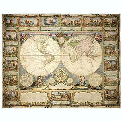
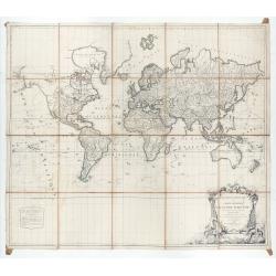
Mappemonde contenant les parties connues du globe terrestre dressée suivant de nouvelles observations
Wall map of the world in two hemispheres printed on two sheets, depicting the Eastern and Western hemispheres supported by two male figures, decorated at the bottom right...
Date: Paris, Longchamps et Janvier, 1754
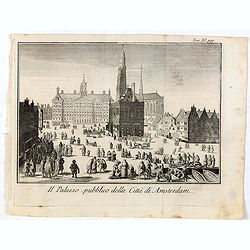
Il Palazzo pubblico della Citta di Amsterdam.
Fine panoramic views of the Dam square in Amsterdam, taken from Storia moderna di tutti I popoli del mondo , edited by Thomas Salmon. A Italian edition of this famous wor...
Date: Venice, 1740-1756

La Saxe Contenant le Routes et les postes. . .
Fine post-route map of Saxony in Germany with a splendidly engraved title cartouche. The map is centered on Leipzig. George Louis Le Rouge was active between 1740 and 178...
Date: Paris, 1756
Selling price: ????
Please login to see price!
Sold in 2025
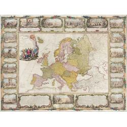
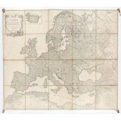
L'Europe divisée en tous ses états, dressée sur les nouveaux mémoires et suivant les dernières observations.
Rare wall map of the European continent, published by the Parisian publisher Sébastien G. Longchamp.The map is surrounded by a magnificent Rococo-style frame decorated w...
Date: Paris, 1757
![Ch'onha chido.[Atlas of all under Heaven]](/uploads/cache/44639composition-world-250x250.jpg)
Ch'onha chido.[Atlas of all under Heaven]
A late 18th-century Ch'onha chido atlas with 13 woodblock maps showing the World, China, Korea, Japan, Okinawa, and the 8 provinces. The seas are in black.Slight wear, co...
Date: Korea, ca. 1760

Carta Topografica dell' Isola Del Maritaggio di Monsieur le Boble per la prima volta. Tradotta dal francese in italiano.
Second Italian printing of Eustache Le Noble’s "Carte de l’isle de marriage." The book’s text offers instructions on how to reach this matrimonial island ...
Date: Cosmopoli, 1766
![The Coast of New Found Land From Salmon Cove to Cape Bonavista. . . [together with] The Coast of New Found Land from Cape-Raze to Cape St-Francis.](/uploads/cache/40658-250x250.jpg)
The Coast of New Found Land From Salmon Cove to Cape Bonavista. . . [together with] The Coast of New Found Land from Cape-Raze to Cape St-Francis.
Two charts showing the coast of New Found Land from Salmon Cove to Cape Bonavista and from Cape-Raze to Cape St-Francis. With inset chart of Trinity HarborGrierson publis...
Date: Dublin, 1767

Plan der Stadt Quebec Haupstadt in Neu Franckreich oder Canada.
Town-plan of Quebec, with an inset view of the town in the lower right corner. In the upper right a recapitulation of the main military actions prior to the surrender of ...
Date: Nurnberg, 1770

A chart of the China Sea inscribed to Monsr. D'APRES de MANNEVILLETTE .. To A.Dalrymple.
This most important milestone chart is based upon the surveys made from navigational surveys by Alexander Dalrymple (1737-1808]. He was the first hydrographer of the Brit...
Date: Paris, ca 1775
![[ Text / title page Charts of the coasts and harbours of New England . . .]](/uploads/cache/44832-250x250.jpg)
[ Text / title page Charts of the coasts and harbours of New England . . .]
Letterpress text page, taken from the "Atlantic Neptune".The Atlantic Neptune is universally recognised as one of the most magnificent atlases ever made.Example...
Date: London, 1777

Carte Réduite Des Côtes Orientales De L' Amérique Septentrionale Contenant Partie du Nouveau Jersey.. Virginie.. Georgie..
Uncommon chart that extends from Delaware Bay and Philadelphia south through much of Georgia to Island Amelia and St. Johns River. Fleur-de-lis and rhumb lines fill the s...
Date: Paris, 1778
![[Title page] Atlante Novissimo, Tomo I . . .](/uploads/cache/43898-250x250.jpg)
[Title page] Atlante Novissimo, Tomo I . . .
Decorative Venitian frontispiece from Antonio Zatta's "Atlante Novissimo tomo I".
Date: Venice, 1779
![Ch'onha chido. [Atlas of all under Heaven]](/uploads/cache/44640-250x250.jpg)
Ch'onha chido. [Atlas of all under Heaven]
A late 18th-century Ch'onha chido atlas with 10 woodblock maps showing the World, China, and the 8 province maps of Korea (Hamgyeong, Gangwon, Jeolla, Gyeongsang, Pyeonga...
Date: Korea, ca. 1780
![[Lot of 4 charts] Plan de la Baie et du Port de Camraigne / Plan de la Baie de Niatrang et du Golfe de Binkang / Plan de la Cote de Cochinchine. . . / Plan des Ports de Xuandai, Vung-Lam. . .](/uploads/cache/44795A-250x250.jpg)
[Lot of 4 charts] Plan de la Baie et du Port de Camraigne / Plan de la Baie de Niatrang et du Golfe de Binkang / Plan de la Cote de Cochinchine. . . / Plan des Ports de Xuandai, Vung-Lam. . .
[A set of four French sea charts numbered consecutively]. A set of 4 basic coastal sea charts of parts of southern French Indochina (Vietnam).Chart 295 centers on the reg...
Date: Paris ca 1780
![[Title page for] Recueil de cartes sur la geographie ancienne . . .](/uploads/cache/47729-250x250.jpg)
[Title page for] Recueil de cartes sur la geographie ancienne . . .
Title-frontispiece of "Recueil de cartes sur la geographie ancienne", published by Rigobert Bonne in 1783, engraved by Louis Legrand.More about title pages [+]
Date: Paris, 1783
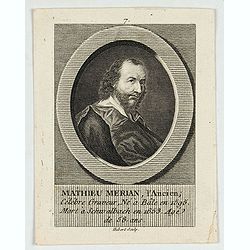
M.Merian, l'Ancien célébre graveur . . .
Portrait of Matthäus Merian (1593-1650) by Hubert. Matthäus Merian der Ältere was a Swiss-born engraver who worked in Frankfurt for most of his career, where he also ...
Date: Paris, 1784
![[Title page] Atlante Novissimo, illustrato ed accresciuto . . .](/uploads/cache/43897-250x250.jpg)
[Title page] Atlante Novissimo, illustrato ed accresciuto . . .
Decorative Venitian frontispiece from Antonio Zatta's Atlas Atlante Novissimo, illustrato ed accresciuto . . . . The outer decoration of this title page has a wealth of c...
Date: Venice, 1785
Mappemonde ou carte générale du globe terrestre dessinée suivant les règles de la projection des cartes réduites…
Large world map showing the sea tracks of Captain Cook in his three Pacific voyages published by C. F. Delamarche.Rare state 4, dated 1786, of this large world map, featu...
Date: Paris, Robert de Vaugondy/Delamarche, 1786
![[Crimea]. Carte de la Cromée.](/uploads/cache/25719-250x250.jpg)
[Crimea]. Carte de la Cromée.
Mapmaker, Captain Jan Hendrik van Kinsbergen (1735-1819). Published by H. Friesman in 1787. This map first appeared in 1776 and was the first Russian map of the newly ann...
Date: Amsterdam, H. Frieseman, 1787

Carte d'Asie divisée en ses principaux Etats.
Uncommon and decorative "carte à figures" - wall map, prepared by Clouet, with superb decoration, including a wonderful rococo border with 20 decorative vignet...
Date: Paris, Mondhare, 1787

Carte d'Europe divisée en ses Empires et Royaumes.
Uncommon and decorative wall map of Europe, prepared by Clouet. Superb decoration including a wonderful rococo border with vignettes describing historical scenes. Below t...
Date: Paris, Mondhare, 1788
![[Title cartouche from Carte de la France]](/uploads/cache/47726-250x250.jpg)
[Title cartouche from Carte de la France]
Title cartouche from "Carte de la France", prepared by Captaine and published by Pierre D. Belleyme.
Date: Paris, ca. 1789
![CH'ONHA CHIDO [Atlas of all under Heaven]](/uploads/cache/33625-250x250.jpg)
CH'ONHA CHIDO [Atlas of all under Heaven]
The Ch’onha chido [Atlas of all under Heaven] is a late 18th century copy of the traditional Korean atlas produced in the early Choson dynasty (1392-1910). One of the m...
Date: Korea, ca. 1790

Dutchman and a Maruyama prostitute.
An explicit scene of a Dutchman and a Maruyama prostitute featuring a gray-bearded westerner coupling with a courtesan. The woman protests that she doesn't understand wha...
Date: Late Edo, 1790

A chart of the northern part of the Indian Ocean..
Complete title in upper right "A Chart of the Northern Part of the Indian Ocean, Containing a Part of the Coast of Africa from Magadasho River to the Straits of Bab-...
Date: London 1794
L'Europe divisée en des Etats, Empires, Royaumes et Républiques.
Large wall map of Europe with inset map of Iceland and cartouche drawn and etched by Arrivet. Revised edition by Charles François Delamarche (1st ed.: 1767), entitled &q...
Date: Paris, (n.d.) c. 1793/1794

SETTSU MEISHO ZUE. Illustrations of famous places in Settsu.
Settsu Meisho Zue was printed in two series of 8 and 4 volumes. The principal illustrator was Takehara Shunchosai, but many illustrations in the 4 volumes supplement are ...
Date: Osaka, Yanagiwara Kibei, Kansei 8-10 or 1796-1798
![[Set of 6 maps] Charta öfver Storfurstendömet Finland på Friherre S. G. Hermelins Anstalt och Omkostnad. Sammandragen och författad af C. P. Hällström. Philos. Magister och Auscultant i Kongl. BergsColl. 1799.](/uploads/cache/34482-250x250.jpg)
[Set of 6 maps] Charta öfver Storfurstendömet Finland på Friherre S. G. Hermelins Anstalt och Omkostnad. Sammandragen och författad af C. P. Hällström. Philos. Magister och Auscultant i Kongl. BergsColl. 1799.
This is a beautiful set of a key map and five separate maps of Samuel Gustav Hermelin's map of Finland. The maps have been engraved by Fredrik Akrel, a very skilled and p...
Date: Källa: J.Strang & E.- S. Harju: Suomen karttakirja 1799

Lion and Bull made of terracotta.
Very fine terracotta figure of a lion symbolizing the continent of Africa. The Bull symbolizing Europe.The items will be dispatched in 4 wooden crates from Belgium. Pleas...
Date: Netherlandisch , 1780~1800

Deutschlands Postkarte begraenzt von Oesterreich, Preussen, Frankreich, Holland, Italien und der Schweiz. . .
A detailed and crucial post-road map prepared by Ignaz Heymann. The map shows the Low Countries, Germany, Poland, Austria, Hungary, etc.Borders in original outline colo...
Date: Triest, 1800
![[Set of two maps of the Pacific Ocean with transportation lines, with Ottoman script]](/uploads/cache/44327-250x250.jpg)
[Set of two maps of the Pacific Ocean with transportation lines, with Ottoman script]
Two post card size maps showing the Pacific Ocean with transportation lines. The maps are in Ottoman script prepared by Mehmet EŞREF in a small atlas : عمومولاي...
Date: Istanbul, Şirket-i Mürettibiye ve Karacoğlu Matbaas, 1800

Shinkan Nagasaki no Dzu.
The oldest of these so-called Nagasaki pictures (Nagasaki-zu) were two panoramic prints by the artist Chikujuken that served as guides to the city of Nagasaki for visitor...
Date: Nagasaki, 1801

Carte des côtes du Golfe du Mexique compris entre la pointe sud de la presqu'Ile de la Floride et la pointe nord de la presqu'Ile d'Yucatan:...
Detailed and important early chart of the Gulf Coast and Florida and dated 1800. First French edition of "the first printed [map] to show and name Galveston Bay&qu...
Date: Paris, 1800/1803
