Browse Listings in Map Types > Pictorial & Advertising

Asia secunda pars in forma Pegasi.
UNRECORDED PLATE or STATE. Asia depicted as the flying horse Pegasus. Below the depiction 3 lines of engraved Latin text. Double page copper engraved map from Heinrich B�...
Date: Brunswick, ca. 1635
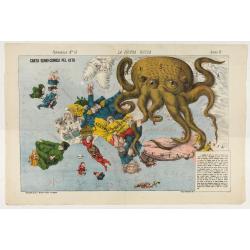
La Piovra Russa. Carta Serio-Comica Pel 1878.
1878 - Rare political caricature map by Grossi of the nations of Europe for the newspaper Le Perroquet / Al papagallo.
Date: Bologne presso il Giornale colorato in Papagallo, 1878
![Hoo Daihiko Kinen Hiko Sugoroku [ [訪欧大飛行記念飛行双六 ]](/uploads/cache/46569-250x250.jpg)
Hoo Daihiko Kinen Hiko Sugoroku [ [訪欧大飛行記念飛行双六 ]
FIRST EDITION. A rare paper board game celebrating a flight from Tokyo to Rome Europe. Published in by Osaka Asahi Shinbun.This color offset-printed sugoroku (a paper “...
Date: Osaka, Taisho 14 or 1925

The Wonderground Map of London.
A large and pictorially striking 'Wonderland' advertising poster on behalf of the London Underground, published in the late 1920s. The poster was very popular, and ran fo...
Date: London, 1927
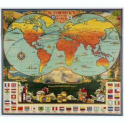
McCormick's Map of the World.
Colorful promotional map of the 20th century spice trade.What better way to showcase the global composition of a multi-national company than with a world map? This lovely...
Date: United-States, 1931

Philippines Islands.
Pictorial map of Philippines Islands, from the famous illustrator, Ruth Taylor White and published in "Our USA: A Gay Geography".Ruth Taylor White was among the...
Date: Boston, Little, Brown and Company, 1935

A Hysterical Map of the Yellowstone Park. . .
A funny 1936 pictorial map of Yellowstone Park, that was 'hatched and scratched' by the American printer and humourist Jolly Elmer Lindgren. This wonderful map covers the...
Date: Spokane, 1936

A Map and History of Peiping; formerly known as Peking; capital of provinces, princedoms and kingdoms since 1121 B.C. . .
The uncommon second edition of this very decorative and informative pictorial map of Beijing and surrounding areas whimsically illustrates the Forbidden City, essential e...
Date: The Peiyang Press, Ltd. Tientsin-Peiping, 1936

The Greyhound Map of This Amazing America. . .
A large colored lithograph map of the USA, published by the Greyhound Corporation during the Second World War. The map demonstrates where all the Greyhound bus routes int...
Date: United States, 1941
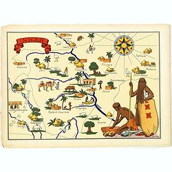
Niger.
Very decorative, informative map of Nigeria. The map is filled with buildings, animals, figures and two locals. With a large compass rose in upper right corner.In lower l...
Date: France, 1943

Carte de la Charte de L'Antique . . .
The rare French version of this decorative pictorial world map by MacDonald Gill. "This magnificent map drawn up while the Second World War still raged is already en...
Date: London, Alf Cooke Ltd, 1943

ADSEC in Action from Thames to Rhine.
A pictorial map showing the allied movement from London on 14 March 1944 thru the conquest of Germany. Showing the track from London along Bristol, crossing the British C...
Date: London, 1945

Coast to Coast.
A game board that features a map of the U.S. with a built-in spinner. Players travel a circular track around the map visiting landmarks as they go. A fun way to learn geo...
Date: New York, ca. 1950
![[Planisphère] - Crédit Lyonnais - Fondé en 1863. Afrique du Nord à Union Française.](/uploads/cache/44865-250x250.jpg)
[Planisphère] - Crédit Lyonnais - Fondé en 1863. Afrique du Nord à Union Française.
Original pictorial lithographed advertising poster showing the western part of Africa. Published by the French bank Crédit Lyonnais.Design by Lucien_Boucher who is a fam...
Date: Paris, 1950

A map of the British Army with battle honours and militray achievements and Regimental Badges . . .
Shows English County Regiments, Battle Honours and Military Achievements. Bordered by Regimental Badges.A fascinating piece of British history.Read more about Pictorial M...
Date: London, 1952
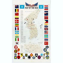
Pacific Stars and Strips Map of the War.
A detailed map of the Korean War. Several silhouetted flying military aircraft are shown in formation. The map shows the Korean Peninsula from its northern border with Ru...
Date: America, 1953

(World map). Americus Vespucio novo te Duce Ducta Freto Ambivi Meritoqs Vocor.
Manuscript world map showing the American and African continent and the southern parts of Asia. In the Indian Ocean a large depiction of Amerigo Vespucci 1454 – 1512) o...
Date: Italy, ca. 1954
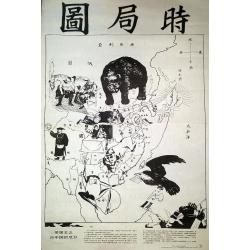
The Situation in the Far East. (時局圖)
An unusual rendering of Tse's "Situation in the Far East". Tse Tsan-tai (1872-1939), a Chinese patriot, drew the original political cartoon in Hong Kong in 1899...
Date: China, n.d. but ca. 1980/1990
