
Matching set of four wallmaps of America, Asia, America, Europe. |
||||||||||||||||||||
|
||||||||||||||||||||
|
|
||||||||||||||||||||
|
|
My Collection + - Save and collect this or any of your favorite items in one place.
If you want to save the items permanently, please sign in or create account first. |
|||||||||||||||||||
Description
Rare and decorative set of four wall maps published by Louis Charles DESNOS ( fl.1750-1770), including a border with vignettes describing native scenes. Each panel is accompanied by descriptive text. The border panels are made up of separate sheets. Total size for each map 780 x 1080 mm / 30.7 x 42.5 inches.. McGuirk has found for the American continent editions dated 1760, 1770, 1772, and 1781. So these are early editions.
These wall maps represent the peak of French decorative cartography in the eighteenth century.
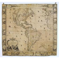
Amerique Septentrionale et Meridionale Divisée en ses pricipaux et subdivisée par audience Dressée sur les Memoires les plus recens et assujetie aux dernieres Observations Astronomiques par le PER et LC Desnos, Geographes Ingenieur pour les Globes et Spheres, rue St Jacques du Globe 1760. With a large "Mer de L'Ouest" or "Sea of the West". Some minor paper loss in upper left corner and in upper center part.
Donald L. McGuirk in The Last Great Cartographic Myth Mer de l'Ouest (map 84) classifies the map as Rare and list four states of the map, dated 1760, 1770, 1772 and 1781.
Mer de l'Ouest labeled, "La Pretendue Mer de l'Ouest". Title is in cartouche, lower left. There is a second title across the top of the map, "AMERIQUE SEPTENTRIONALE ET MERIDIONALE/ DIVISÉE EN SES PRINCIPAUX ET SUBDIVISÉE PAR AUDIENCE/...".
The borders contain historical scenes of De Soto arriving in Florida in 1549, Floridians and Whaling fishing, Spanish arrival at Cuba, Murder of Baldivio and 20 of his companions at Jamaica, Gold sources in Guatemala, Inhabitants of Peru, Inhabitants along the River de la Plata, Murder of Pedro Gutiérrez de Valdivia or Valdiva, a Spanish conquistador and the first royal governor of Chile. Valdivia's successor El Mozo Almagro, habitants in Peru, Andes Mountains, Cod fishing in Newfoundland, etc.
Size 780 x 1080 mm / 30.7 x 42.5 inches
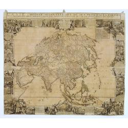
L'Asie dressée selon l'étendue de ses principales parties. . .
Surrounded by magnificent vignettes showing the different people of Asia. Each panel is accompanied by descriptive text about China, Japan, Tunquin, Siam, Malaysia, Georgie, Armenian, Emirates, India, Arabia, Moluccas, and Turkish traders.
The great Jesuit surveys of China and the Far East revealed by d'Anville in his Nouvel Atlas de la Chine (1737) must also here have provided important sources of geographical materials. D'Anville rejected de Vries' assumption that the coastline of Sakhalin was continuous with that of Hokkaido.
The wall map is of interest for the use of Mer de Corée
Size 780 x 1080 mm / 30.7 x 42.5 inches
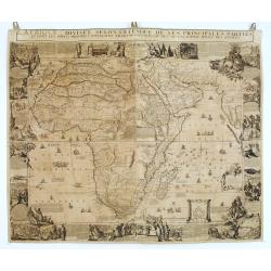
L'Afrique, Divisée selon l'étendue de ses principales parties et dont les points principaux sont placez sur les observations des mes rs de l'academie Royale des Sciences. / Dedié à Monseigneur Le Dauphin par son tres humble tres obeissant serviteur Desnos Geographes Ingenieur pour les Globes et Spheres 1760.
This map has an inset of the Castle and Fort at Cape of Good Hope in the lower part. Engraved by H. van Loon.Size 780 x 1080 mm / 30.7 x 42.5 inches
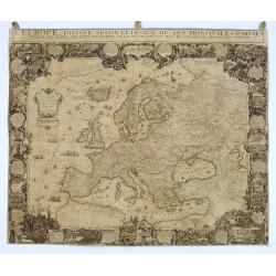
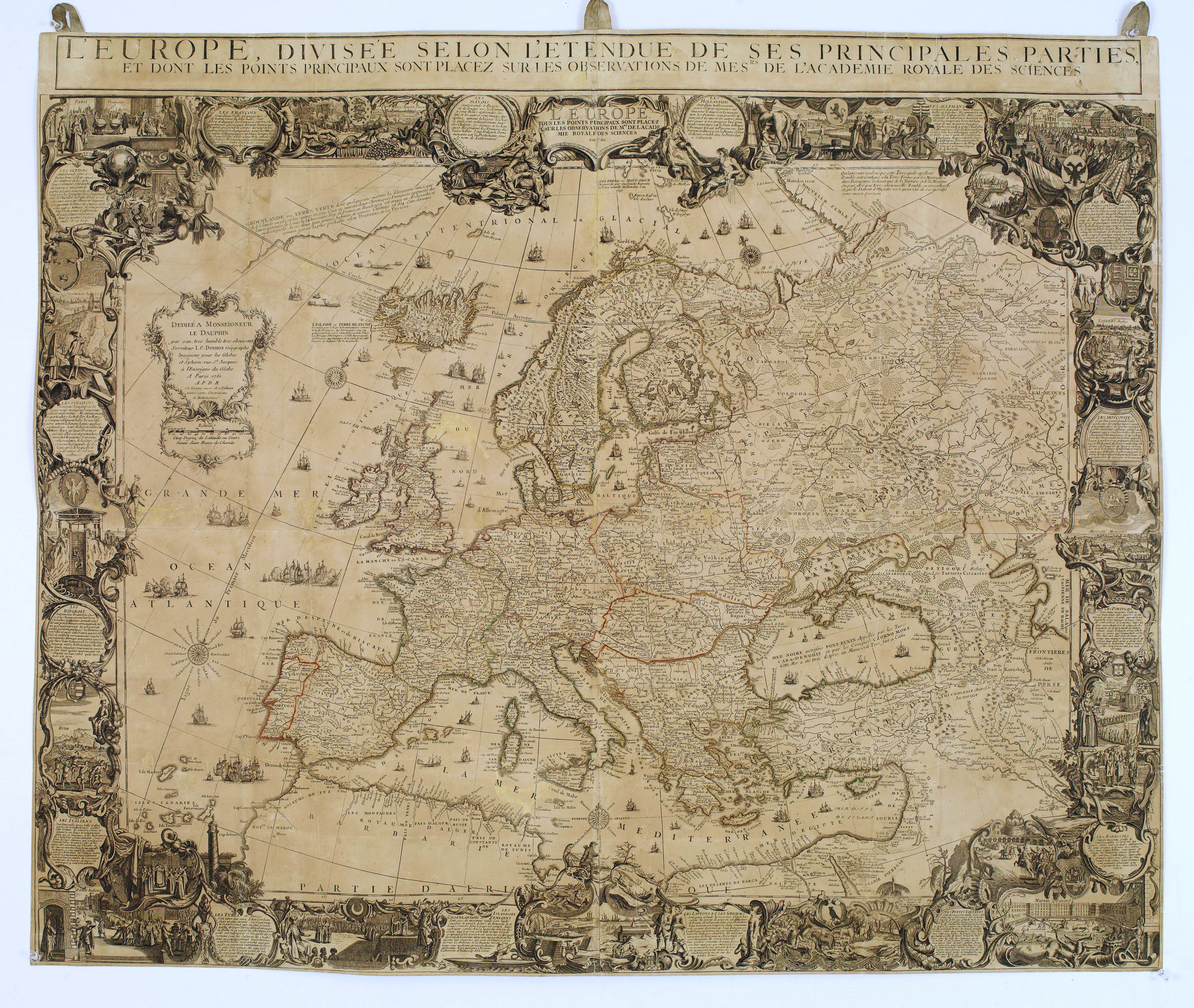
L'Europe. Tous les Points principaux font placés sur les observations de Mrs de l'Academie Royale des Sciences en 1761.
The map is surrounded with insets showing little views of Stockholm, Budapest, Rome, Madrid, Lisbon, Moscow, London, Amsterdam and descriptive texts of France, Poland, Turkey, Greenland, Iceland, Nova Zembla, Lapland, Spain, Portugal, Russians, England and Holland.Size 780 x 1080 mm / 30.7 x 42.5 inches
Wall map hangs beside the finest paintings in the offices of prosperous merchants, in the halls of government and the homes of the wealthy. See, for example, the paintings of Vermeer, where wall maps appear in various settings. This work's ornamentation exceeds the pictorial richness usually achieved on a map.
As often with wall maps have suffered more than atlas maps and have the usual small repairs of splits and missing areas. This matching set of 4 continent wall maps has some paper browning but is generally in good condition and still in its original outline color.
These wall maps represent the peak of French decorative cartography in the eighteenth century.
Read more about wall maps and figured border maps [+]
FAQ - Guarantee - Shipping
Buying in the BuyNow Gallery
This item is available for immediate purchase when a "Add to Cart" or "Inquire Now" button is shown.
Items are sold in the EU margin scheme
Payments are accepted in Euros or US Dollars.
Authenticity Guarantee
 We provide professional descriptions, condition report (based on 45 years experience in the map business)
Paulus Swaen warrants the authenticity of our items and a certificate of authenticity is provided for each acquired lot.
Condition and Coloring
We indicate the condition of each item and use our unnique HiBCoR grading system in which four key items determine a map's value: Historical Importance, Beauty, Condition/Coloring and Rarity.
Color Key
We offer many maps in their original black and white condition. We do not systematically color-up maps to make them more sellable to the general public or buyer.
Copper engraved or wood block maps are always hand colored. Maps were initially colored for aesthetic reasons and to improve readability. Nowadays, it is becoming a challenge to find maps in their original colors and are therefor more valuable.
We use the following color keys in our catalog:
Original colors; mean that the colors have been applied around the time the map was issued.
Original o/l colors; means the map has only the borders colored at the time of publication.
Colored; If the colors are applied recently or at the end of the 20th century.
Read more about coloring of maps [+]
Shipping fee
A flat shipping fee of $ 30 is added to each shipment by DHL within Europe and North America. This covers : International Priority shipping, Packing and Insurance (up to the invoice amount).
Shipments to Asia are $ 40 and rest of the world $50
We charge only one shipping fee when you have been successful on multiple items or when you want to combine gallery and auction purchases.
Read more about invoicing and shipping
FAQ
Please have a look for more information about buying in the BuyNow gallery
Many answers are likely to find in the general help section.
My Collection+
![]()
With My Collection+ you can collect all your favorite items in one place. It is free, and anyone can create his or her virtual collection.
Unless you are logged in, the item is only saved for this session. You have to be registed and logged-in if you want to save this item permanently to My Collection+.
Read More[+]
Register here, it is free and you do not need a credit card.
Add this item to
My Collection+
or click the following link to see My Collection+.
| Digital Image Download | |
|
Paulus Swaen maintains an archive of most of our high-resolution rare maps, prints, posters and medieval manuscript scans. We make them freely available for download and study. Read more about free image download |
Click the image for a free small image download. |
In accordance with the EU Consumer Rights Directive and habitually reside in the European Union you have the right to cancel the contract for the purchase of a lot, without giving any reason.
The cancellation period will expire 14 calendar days from the day after the date on which you or a third party (other than the carrier and indicated by you) acquires, physical possession of the lot. To exercise the right to cancel you must inform Paulus Swaen Inc, of your decision to cancel this contract by a clear statement (e.g. a letter sent by post, or e-mail (amsterdam@swaen.com).
To meet the cancellation deadline, it is sufficient for you to send your communication concerning your exercise of the right to cancel before the cancellation period has expired.
