Browse Listings in Map Types

Géographie des Plantes Equinoxiales - Tableau physique des Andes et pays voisins. . .
Physical Portrait of the Andes and adjacent lands", organized around the Chimborazo and Cotopaxi volcanoes in Ecuador.With local vegetation is illustrated pictoriall...
Date: Paris, 1805
![Morokoshi Meisho Zue [Illustrated Description of Famous Sites of China].](/uploads/cache/34118-250x250.jpg)
Morokoshi Meisho Zue [Illustrated Description of Famous Sites of China].
Published in Osaka, Kawachiya Genhichiro, et al. [8 book sellers], slightly later issue but apparently in Edo period, using all the same woodblocks of original first edit...
Date: Osaka, Edo, slightly later than Bunka 3, year of the tiger - 1806

Plan de la Baie de L'Adventure. . .
A French maritime chart of Adventure Bay in S.E. Tasmania. Adventure Bay is the name of both a township and a geographical feature on the eastern side of Bruny Island. Th...
Date: Paris, ca 1807

Plan du Port du Sud de la Baie de la Recherche / Croquis de la Baie des Moules. . .
A French maritime chart of the Port du Sud in Research Bay and the mouth of the Bay of Mussels, both in southern Tasmania. This is the edition of the extremely rare atlas...
Date: Paris, ca 1807
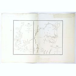
Plan du Port Jackson / Plan du Comte de Cumberland.
Two maps on one sheet showing the earliest scientific surveys of Port Jackson and the area surrounding Sydney Harbour, undertaken by the French in 1802. This is the editi...
Date: Paris, 1807

Plan de L'Isle de Paque / Plan de la Baie de Cook.
Two engraved maps and four coastal profiles of Easter Island in the Pacific. First published in the Atlas du Voyage de la Perouse. This is the edition of the extremely ra...
Date: Paris, 1797-1807

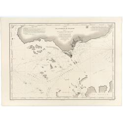
Carte de L'Archipel de La Recherche a la partie Occidentale de la Terre de Nuyts. . .
A large and detailed chart of the southern West Australian coast centered on the region of Esperance and the surrounding islands.Terre de Nuyts is the name that was forme...
Date: Paris 1807
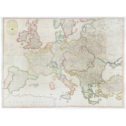
(Post Roads of Europe) Neueste Allgemeine Postkarte von Europa in welcher samtliche Postrouten aller europaischen Staaten nach den zuverlässigsten Postbüchern. . .
The largest postal map of Europe, published in Vienna in the midst of the Napoleonic Wars. This postal map of Europe first appeared in 1798 and is considered one of the e...
Date: Vienna, 1807

Carte Réduite Du Golphe Du Mexique Et Des Isles De L' Amérique..
A well engraved and highly detailed chart prepared by Bellin of the Gulf of Mexico and the Caribbean. In addition to a magnificent title cartouche and a color key to the ...
Date: Paris dated year 17, or 1808

Karte vom Koenigreiche Ungarn mit Einschluss der Königreiche Kroazien und Slavonien dann von dem Grossfürstenthume Siebenbürgen.
Wall map of the Kingdom of Hungary in 8 sheets mounted on canvas, preserved in their original case. The map has a graduated margin and is enclosed in a simple yet decorat...
Date: Vienna, 1809
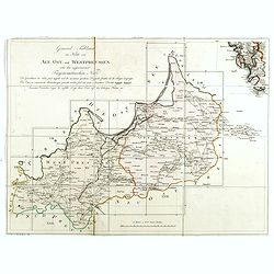
(Index sheet) General Tableau zur Karte von Alt Ost und West Preussen nebst dem aufgenommenen Trigonometrischen Netz. . .
Index sheet of this important multi-sheet map of Prussia, Lithuania, and Poland.Section XXIV of the rare first edition of this important 25-sheet map prepared by Friedric...
Date: Berlin, 1802-1810
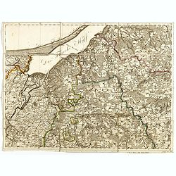
(Sheet X with Puk Bay from) General Tableau zur Karte von Alt Ost und West Preussen nebst dem aufgenommenen Trigonometrischen Netz. . .
Sheet IV with Zalew Wislany and the towns of Elblag, Paslek, Braniewo, etc, of this important multi-sheet map of Prussia, Lithuania, and Poland.The rare first edition of ...
Date: Berlin, 1802-1810

Carte von West=Gallizien welche auf allerhöchsten Befehl Seiner Kaiserlich oesterreichischen und Königlich apostolischen Majestät in den Jahren 1801 bis 1804. . .
Important early map of Western Galicia, as given to Austria by the third Partition of Poland (1795). Due to its lengthy development period, a rare map rich in detail depi...
Date: Vienna, (1808) after 1811
![[Title page] Voyage de découvertes aux terres Australes éxécuté par ordre de S.M l'Empereur et Roi.](/uploads/cache/39732-250x250.jpg)
[Title page] Voyage de découvertes aux terres Australes éxécuté par ordre de S.M l'Empereur et Roi.
Set of two title pages from the atlas part of "Voyage de decouvertes aux terres australes", Freycinet and Peron's accounts of the French cartographic expedition...
Date: Paris, Langois, 1811
![[Title page] Voyage de découvertes aux terres Australes . . . Deuxieme partie.](/uploads/cache/46363-250x250.jpg)
[Title page] Voyage de découvertes aux terres Australes . . . Deuxieme partie.
Title page of the atlas Voyage de découvertes aux terres Australes by François Péron, 1824. The French expedition under Nicolas Baudin, was commissioned to chart the coas...
Date: Paris, 1807-1816

Langley's New Travelling and Commercial Map . . .
A highly desirable, detailed and uncommon map of England and Wales, published by Langley and Belch. The map is flanked by a pair of large and detailed explanation tables,...
Date: London, 1817

Manuscript plan of Havana harbour.
Manuscript chart with good nautical detail and soundings of Havana harbour.
Date: Spain c.1820

Carte générale de l' Amérique divisée en ses principaux états . . .
Map of North and South America. By C. F. Delamarche, successor of Robert de Vaugondy, Geographer. Descriptive text to the left.
Date: Paris, 1820

London in Miniature With The Surrounding Villages. An Entire New Plan In which the Improvements both present and intended are actually reduced, by permission, from the surveys of the Several Proprietors. . .
Hand-coloured engraved map, dissected and mounted on linen, orange publishers label on one side, extending west to east from Kensington to East India and Greenwich Dock a...
Date: London, 1821
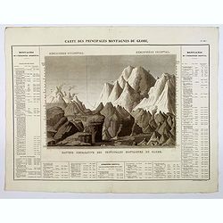
Carte des Principales Montagnes du Globe.
A nice detailed depiction of the principal mountains of the world from Buchon's Atlas Gégraphique Statistique, historique et chronologique des deux Ameriques et des isles...
Date: Paris, 1825

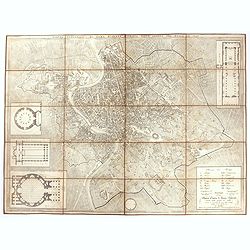
Pianta Della Citta di Roma con la Indicazione di tutte le Antichita e Nuovi Abbelliment.
Beautifully engraved town plan of Rome, featuring side borders that depict the 16 most important monuments, along with a legend that locates the significant places and bu...
Date: Venanzio Monaldini, Rome, 1829
Pianta topografica di Roma moderna estratta dalla grande del Nolli an 1829
Town plan of Rome based on map by Giovanni Battista Nolli, ( fl. 1692-1756). Engraved by Pietro Ruga. With a key (I - XIV), scale and text "Nuova pianta di Roma mode...
Date: Rome, 1829

Nouveau Plan Routier de la Ville et Faubourgs de Paris // Avec ses principaux Edifices et Nouvelles Barrieres.
Decorative large-scale wall map of Paris, published by M. P|chon in Paris and engraved by Michel Glot. The plan is framed by a floral border and there are 27 Parisian vie...
Date: Paris, 1834
![Aou, Tōkei. Kokugun Zenzu [Atlas of Provinces and Counties of Japan]. (volume 1 only)](/uploads/cache/63619-250x250.jpg)
Aou, Tōkei. Kokugun Zenzu [Atlas of Provinces and Counties of Japan]. (volume 1 only)
First edition. Very attractive early Japanese Atlas of detailed maps of Japanese regions compiled by six Japanese civilians in the eighth year (1837) of the Tenpō era (1...
Date: [Nagoya]: Tōheidō, Tenpō 8 = 1837

Carte du pays de Montenegro dressée d'après les opérations géodétiques . . .
Rare map of Montenegro prepared by Mr. le Comte Fedor de Karacsay (1787-1859) and engraved by Pietro Allodi. The title is in Russian, Arabic and French.In lower left corn...
Date: Vienna, ca. 1838

Kaart van de Gaspar Straaten volgens opnemingen van J.Stolze, D.Ross, enz.
Very large and rare chart centered on the strait between Bangka's southeastern seacoast and Belitung's western shores.Short front views of the coastal relief are shown in...
Date: Amsterdam 1843
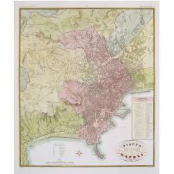
Pianta della citta di Napoli.
Published in Atlante Geografico dell' Italia. Uncommon and decorative town-plan of Naples. With a numbered key.Engraved by P.Manzoni.
Date: Florence, 1845

Kaart van de Reede van Batavia met de verschillende vaarwaters naar dezelve trigometrisch opgenomen op last van deb schout bijnacht E.Lucas.
Very large and rare so-called blue-black chart centered on Jakarta's harbor.The chart is prepared by B.G.Escher, I.A.C. Eschauzier, B.H.Staring and E.H.Boom during an exp...
Date: Amsterdam (1841) 1847

Kaart der Moluksche eilanden en vaarwateren … F.A.A. Gregory Luitenant ter zee …
Huge sailing chart centered on the Moluccas Islands. Published by Widow Gerard Hulst van Keulen.The publishing house van Keulen, were the most prominent chart makers at ...
Date: Amsterdam, 1847
Carte des Détroits Singapore, Durain..
An exceptionally rare nautical chart of Singapore and direct vicinity issued by Urban Dortet de Tessan, under the patronage of Louis Philippe I of France. When Singapore...
Date: Paris, 1848

Plan de Constantinople, non compris ses faubourgs. Grave d'apres les documents du ministere de la Guerre par E. Olivier.
A very rare lithographic large-scale town-plan of Istanbul, Scale 98 yards to one inch., printed in Pera, Istanbul by E. Olivier. The ornate design on the top of the t...
Date: Péra, Istanbul, 1851

The town & harbour of Sevastopol with the batteries & approaches. . .
Rare colored linen backed map showing the harbour and town of Sevastopol, with soundings. In upper left corner a inset map (65x150mm) of the Black Sea. In bottom part a l...
Date: London, March 27th, 1854
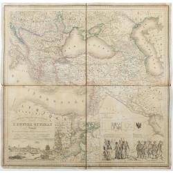
Carte du theatre de la guerre L'Empire Ottoman ..
Very detailed and decorative map of the Ottoman Empire. Lower left a fine panoramic inset (185x80mm) with a view of Istanbul. Next to it a inset map of the Baltic Sea and...
Date: Rouen/ Paris, 1854

(Lübeck) Lvbeca vrbs. imperialis libera. civitatvm. Wandalicarvm. . . .
Impressive, more than 3 meters wide panoramic town view after a woodblock engraving from Elias Diebel, initially made in 1552. Of this original woodblock, Bachmann mentio...
Date: Germany, c. 1855

The Crimea by James Wyld Geographer to the Queen & H.R.H. Prince Albert.
Fourth edition of this folding map of the Crimea. In upper right corner an inset map of the areas around the Black Sea; "The Town & Harbor of Sevastopol with the...
Date: London, 1855
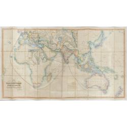
The Pathways of Empire Delineated: Map Showing The Steam Comunication And Overland Routes between England, India, China & Australia…
An illuminating and attractive map that illustrates one of the foundations of British imperial power--the key trade routes by both land and sea between England and its fa...
Date: London, 1856
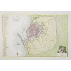
Pianta della citta di Livorno.
Very finely engraved and detailed plan of Livorno. Engraved by V.Angeli and included in: Atlante Geografico dell Italia . To the left, a key to the principal buildings an...
Date: Rome, 1860
![[Title page] Album delle principali vedute di Venezia disegnate da Marco Moro. . .](/uploads/cache/32269-250x250.jpg)
[Title page] Album delle principali vedute di Venezia disegnate da Marco Moro. . .
The title page has a virgin and the lion of Saint Mark sitting on an island with the background of the town of Venice. Learn more about map printing and views of Venice ...
Date: Venice, G. Brizeghel, ca 1860

(Untitled view from Scutari with a view of Constantinople)
Panoramic view from Scutari with a view of Constantinople in the distance, after a design by Johann Schranz. Published by J. Missiriè.
Date: Paris, 1860
![[Europe depicted as a Queen]](/uploads/cache/41499-250x250.jpg)
[Europe depicted as a Queen]
Among the most striking of early cartographic curiosities is Europe regina or Queen of the world first published by Johannes Bucius' and populized by Sebastian Münster.. ...
Date: France, ca. 1860

Plan de la rade de Macao (chine) Levé d'après les ordres mr. Rocquemaurel.
Very detailed chart of Macao and several of the surrounding Islands, and features numerous depth soundings throughout. Prepared by captain, Gaston de Rocquemaurel. Logo o...
Date: Paris, c.1856 / 1863

Kiepert's Physikalische Wandkarten. VI. Nord-America.
Large folding school wall map of North and Central America printed in chromo-lithography. Published by Dieter Reimer and printed by Leopold Kraatz in Berlin. Three inset...
Date: Berlin, Dieter Reimer, 1864

North Pacific.
Huge three sheet so-called Blue-back sailing chart of the Northern Pacific including China, Korea (with Matu Is. and Liancourt), Japan, Philippines, Kamchatka, Hawaii, Al...
Date: London, 1868

L'Homme A La Boule.
Satirical print in which Count Otto von Bismarck balances on the world with one spurred foot entering France, and wearing only his underpants which are marked with the Ge...
Date: Paris, 1870-1871

L'Homme A La Boule.
Satirical print in which Count Otto von Bismarck balances on the world with one spurred foot entering France, and wearing only his underpants which are marked with the Ge...
Date: Paris, 1870-1871

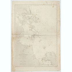
Mer de Chine - Detroit De Singapour Partie Comprise Entre Singaour et Le Dett. De Malacca d'apres les travaux du Commr. J.W. Reed de la Marine Royale d'Angleterr...
Mer de Chine - Detroit De Singapour Partie Comprise Entre Singaour et Le Dett. De Malacca d'apres les travaux du Commr. J.W. Reed de la Marine Royale d'Angleterr, execute...
Date: London, 1871
Mer de Chine - Carte des Iles et Détroits entre Singapoure et le Détroit de Banca. Dréssée d'après le stravaux Anglais et Hollandais plus récents, par Mr. L. Manen . . . 1866
A nautical chart of Singapore and neighboring islands. The first edition of the chart was published in 1866 from French and English sources, this is the corrected version...
Date: London, 1866-1871

Mer de Chine - Detroit De Singapour Partie Comprise Entre Singaour et Le Dett. De Malacca d'apres les travaux du Commr. J.W. Reed de la Marine Royale d'Angleterr, ...
A detailed chart of Singapore Strait, drawn from an English Chart by J.W. Reed, who surveyed Singapore and environs between 1865 and 1869, aboard the H.M.S. Rifleman.The ...
Date: Paris, 1873

La Pieuvre Germanique.
Scarce lithographed plate not dated, by Eugène Danzanvilliers, printed by Grandremy in Paris. The plate listed by Adhemar is dated 1874. Eugène Danzanvilliers was a draug...
Date: Paris, 28 Quai de la Rapée, c.1874

La pericolante ostinata. Papagallo No. 20 Anno II.
Design by Augusto Grossi. Taken from the Italian satirical newspaper Il Papagallo, a satirical magazine founded in January 1873 by Augusto Grossi (1835-1919), which speci...
Date: Bologne, 1874

Trop d'Appetit par A. Le Petit.
Dated in lower right dated "Le 9 juin 1875". The drawing is representing an alligator's jaw wearing a Prussian helmet, and about to chew a globe. Alfred Le Peti...
Date: Paris, 1875

Un Reclutatore in India. Papagallo No. 42. Anno VI.
A British recruter in India. Design by Augusto Grossi. Taken from the Italian satirical newspaper Il Papagallo, a satirical magazine founded in January 1873 by Augusto Gr...
Date: Bologne, 1878
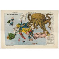
La Piovra Russa. Carta Serio-Comica Pel 1878.
1878 - Rare political caricature map by Grossi of the nations of Europe for the newspaper Le Perroquet / Al papagallo.
Date: Bologne presso il Giornale colorato in Papagallo, 1878
![Jules Verne Le Tour du Monde en 80 jours. [Goose game board inspired by Jules Verne's novel Tour du Monde en 80 jours.]](/uploads/cache/44919-250x250.jpg)
Jules Verne Le Tour du Monde en 80 jours. [Goose game board inspired by Jules Verne's novel Tour du Monde en 80 jours.]
Goose game board inspired by Jules Verne's novel, whose boxes are illustrated with color lithographs and the center occupied by a world map. Vignette illustrations number...
Date: Paris, ca. 1880

Driving chart of Hartford and vicinity : 15 miles around.
Road map by Albert A. Hyde & Co. of Hartford and vicinity, with the Connecticut River in the center. Published by Albert A. Hyde & Co., in New York and lithograph...
Date: New York / Philadelphia, 1884

Wandkarte von Europa von H.Berghaus. . .
Large wall map of Europe printed in chromo-lithography. Prepared by Heinrich Berghaus and published by Justus Perthes in Gotha.Heinrich Berghaus, with support of Alexande...
Date: Gotha, Perthes, ca.1885

Kaart van Het Noordelijk Gedeelte Van Het Eiland Borneo.
A very detailed map of Northern Borneo including Brunei, taken from the "Atlas der Nederlandsche bezittingen in Oost-Indië", which was published by Departement ...
Date: The Hague, 1883-1885

Russia & Poland.
Charming, folding map of Russia and Poland, giving a detailed overview of Europe from Baltic to Caspian Sea. Railways and rivers prominently delineated.In lower left a ke...
Date: London, ca. 1890
A Chart of the World on Mercator's Projection Shewing the Principal Ocean Steam Routes, the Submarine Telegraphs &c.
Charming, folding world map on Mercator's projection showing extensive steam routes and underground and undersea telegraph cables. The map is annotated in blue and red wi...
Date: London, ca. 1890
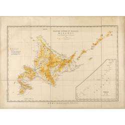
Topographical map of Hokkaido with localities of useful minerals.
Bilingual (English/Japanese) topographic map (1:1,500,000) of Hokkaido Island detailing the distribution of mineral deposits and mining sites (“useful minerals”), publish...
Date: Hokkaidōchō (Gouvernement de Hokkaidō), Sapporo, 1891
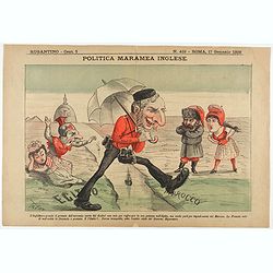
Politica Maramea Inglese - Rugantino - n°419 - Roma 17 Gennaio 1892.
Satirical print relating to the British Conquest of Egypt (1882), also known as Anglo–Egyptian War, between Egyptian and Sudanese forces under Ahmed ‘Urabi and the United...
Date: Rome, January 17, 1892
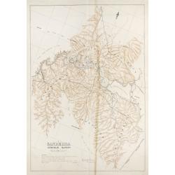
Mountain system of Hokkaido.
Bilingual English/Japanese map of Hokkaido showing elevations, volcanoes and roads for geological observations, with an inset of Chishima (Kuril Islands).
Date: Hokkaidōchō (Gouvernement de Hokkaidō), Sapporo, 1892

Map of Russia and Poland.
Charming, folding map of Russia, Poland and Baltic States, still in its original publisher's blind stamped linen wrapper with yellow label. With yellow advertisements at ...
Date: London, ca. 1894

Chosen Danpan - Korean negotiation.
A scene of a Japanese legation under the command of Hanabusa Yoshitada who is forcing the Korean King Kojong (1852-1919) to agree to Japanese demands during the Chemulpo ...
Date: August 8, MEIJI 27th year or 1894

KOUSHI NYUJO no Zu - HANABUSA Legation enters in Palace, Seoul.
A scene of Japanese legation HANABUSA who are entering the Royal Palace, Seoul.
Date: August 8, MEIJI 27th year or 1894
![[West Central London from Booth's Poverty Map of London]](/uploads/cache/40267-250x250.jpg)
[West Central London from Booth's Poverty Map of London]
A map of West Central London, one section (of twenty) of an extended version of the incredibly influential Poverty Map, originally published in Charles Booth's 'Life and ...
Date: London, 1900
![[Soil map] Virginia-Maryland-West Virginia, Leesburg sheet.](/uploads/cache/23257-250x250.jpg)
[Soil map] Virginia-Maryland-West Virginia, Leesburg sheet.
Early color lithographed soil map by Julius Bien & Co. in New York for Department of Agriculture. Legends at side give detail on soil type, etc. They also include int...
Date: New York, 1903

A Humorous Diplomatic Atlas of Europe and Asia. / 滑稽欧亜外交地図 / Kokkei Ō-A Gaikō Chizu.
A wonderful example of the rare 1904 Kisaburo Ohara satirical 'Octopus Map' of Europe being swallowed by an octopus (Russia). Composed at the outbreak of the Russo-Japane...
Date: Tokyo, April, 1904
![[Set of two maps showing world in Mercator projection, with Ottoman script]](/uploads/cache/44328-250x250.jpg)
[Set of two maps showing world in Mercator projection, with Ottoman script]
Two postcard size maps showing the entire world in Mercator projection. The maps are in Ottoman script prepared by Mehmet EŞREF in a small atlas : عمومولاياةىشهانيىحاوىك...
Date: Istanbul, 1325 or 1909
Canberra Contour Survey.
An important large-scale folding map by Charles Scrivener of the present-day city of Canberra, featuring contour lines and elevation data, created as part of the prelimin...
Date: Department of Lands, Sydney N.S.W. July, 1909

Atlas Geographique. (Puzzle).
Three map puzzles, each measuring 25 x 33 cm., housed in the original color printed card case. Geographical jigsaw puzzle set comprising three maps (world, Europe and Fra...
Date: Paris, ca. 1910
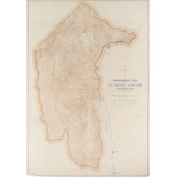
Topographical map of the Federal Territory, Australia.
This map, published by the New South Wales Department of Lands in Sydney in 1910, depicts the Federal Territory—the area designated to house Australia’s future federal ca...
Date: Sydney, Dept. of Lands, 1910
![[Lot of 2 maps] Map of part of New South Wales Australia shewing position of Commonwealth Territory / Map of New South Wales Australia…](/uploads/cache/49457-250x250.jpg)
[Lot of 2 maps] Map of part of New South Wales Australia shewing position of Commonwealth Territory / Map of New South Wales Australia…
Two maps depicting the region of New South Wales and the area designated as the future Commonwealth Territory (which later became the Australian Capital Territory).The fi...
Date: Department of Lands, Sydney NSW, 1911
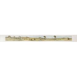
Cycloramic view of Canberra capital site, view looking from Camp Hill / … view looking from Vernon.
Showing an extensive panoramic view of the site of Canberra with various features named. Very large colour photo-mechanical print. Printed by John Sands Ltd [Syd].This 5 ...
Date: Sydney, John Sands, 1911

Nuevo plano de la ciudad de Buenos Aires y parte del partido de avellaneda . . .
A rare detailed city plan of Buenos Aires prepared in 1912 by Ernesto Escalante. The plan depicts the city from the Partido de Avellaneda and the Villa Riachuelo to the R...
Date: Buenos Aires, 1912
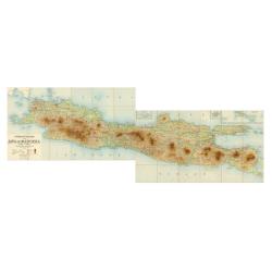
Overzichtskaart van Java en Madoera schaal 1:500.000. Met aanduiding van de politieke indeeling, de organisatie van het bestuur, de bestaande en nog aan te leggen verkeerswegen en van de groote cultuur- en industrieele centra…
If assembled a very large color-printed map (60x 218cm.) of Java and Madoera (Madura Island) on four sheets, each measuring 60 x 54.5 cm, dissected into 12 sections and l...
Date: Atelier Kurkdjian-Soerabaia, 1912
![[Goose game board] Le 1914 Edition pochette.](/uploads/cache/47214-250x250.jpg)
[Goose game board] Le 1914 Edition pochette.
Goose game in the form of a folding map of north of France and Belgium, with part of England, Germany, Holland and Luxembourg.More about board games [+]
Date: Paris, 1914

Mappa Humoristico da Europa.
A really unusual and lovely map, published in Portugal at the outbreak of The Great War in 1914. This outbreak of war in Europe was the result of a complex sequence of ev...
Date: Lisbon, 1914

Hark ! Hark ! The dogs do bark.
This scarce political caricature map of Europe depicts the continent at the outbreak of World War I, or as it was called at the time, the Great War. Designed by Johnson, ...
Date: London, Johnson Riddle & Co.,1914
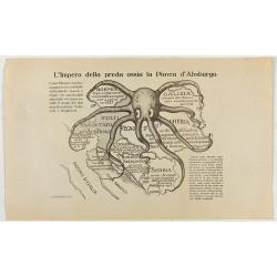
L'Impero della preda ossia la Piovra d'Absburgo.
Austro-Hungarian Octopus zinc lithographed map. A propaganda sheet attacking the Austro-Hungarian Empire, showing it as an octopus with its tentacles wrapped around the v...
Date: La Zincografia, Milan, c. 1915
