Browse Listings in America > North America
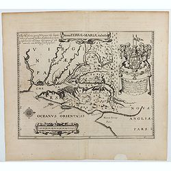
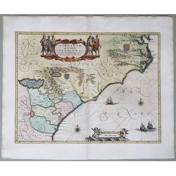
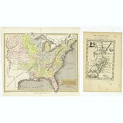
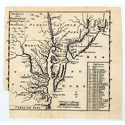
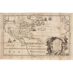
Nova terrae-Mariae tabula.
Double-page engraved map of Chesapeake Bay region, with west oriented at the top, the first printed map of Maryland. Perhaps prepared by Jerome Hawley and John Lewgerand ...
Date: London, ca 1671
Selling price: ????
Please login to see price!
Sold in 2023
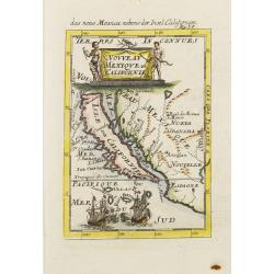
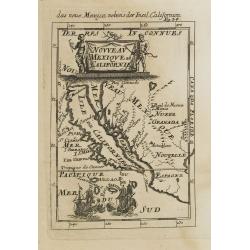
![Noweav Mexiqve. [California as an Island]](/uploads/cache/07724-250x250.jpg)
Noweav Mexiqve. [California as an Island]
Uncommon miniature map of California as a island, from Pierre Duval's La Géographie Universelle dated 1676. The map is derived from Audience de Guadalajara , 1657, by hi...
Date: Paris, 1672
Selling price: ????
Please login to see price!
Sold in 2016
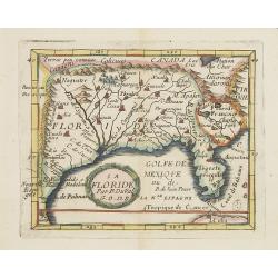
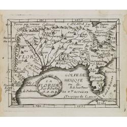
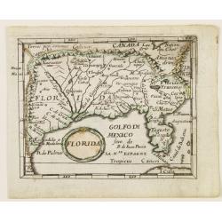
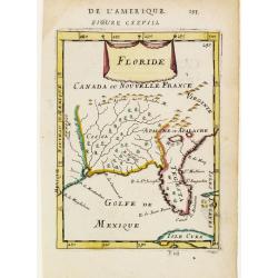
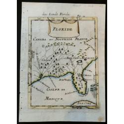
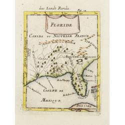
La Floride.
Uncommon miniature map of Florida and Louisiana from Pierre Duval's La Geographie Universeille dated 1676.
Date: Paris, 1672
Selling price: ????
Please login to see price!
Sold in 2013
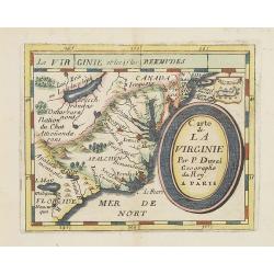
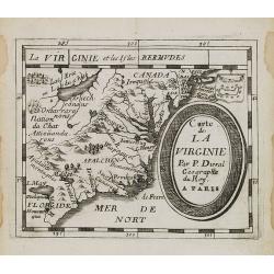
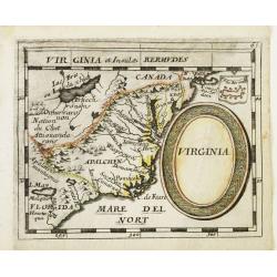
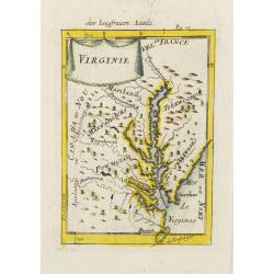
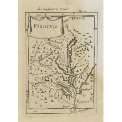
Carte de La Virginie.
Uncommon miniature map of Virginia, from Pierre Duval's La Geographie Universeille . It depicts the now defeated Swedish colony, and the inactive French claim of FLORIDE ...
Date: Paris, 1672
Selling price: ????
Please login to see price!
Sold in 2012
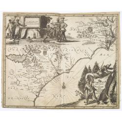
Virginiae partis australis, et Floridae partis orientalis. . .
A beautifully engraved map, derived from the highly influential maps by Mercator and later Blaeu, covering the area from the lower Chesapeake Bay to northern Florida. The...
Date: Amsterdam, 1673
Selling price: ????
Please login to see price!
Sold in 2015
Virginiae partis australis, et Floridae partis orientalis. . . Nova Descriptio.
A map of the East Coast of North America, showing the cost from Chesapeake Bay to the northern part of Florida. The full title in a cartouche at the top reads: Virginiae ...
Date: Amsterdam, 1673
Selling price: ????
Please login to see price!
Sold in 2020
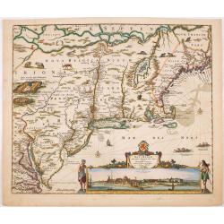
Novi Belgii, quod nunc Novi Jorck vocatur, Novaeque Angliae & Partis Virginiae Accuratissima et Novissima Delineatio.
A beautifully engraved map of the Northeast, extending from the St. Laurence and New England to the Chesapeake and centered on Long Island, which is still shown as an isl...
Date: Amsterdam, 1673
Selling price: ????
Please login to see price!
Sold in 2022
Costes et Rivieres de Virginie, de Mariland et de Nouvelle Angletere. . .
A scarce map that includes the Chesapeake to New England, St. Johns, and Port Royal, showing a single Great Lake "Lake of Herekoys ou Lac des Iroquois." With an...
Date: Paris, Louis Billaine, 1674
Selling price: ????
Please login to see price!
Sold in 2016
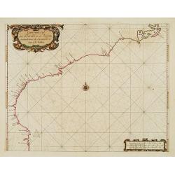
Carte vande Cust van Florida tot de Verginis streckende van Cabo de Carnaveral tot Baya de la Madalena.
An extremely rare and attractive chart of the coast of Florida extending from Cape Canaveral in Florida and following the coasts from South and North Carolina up to Cape ...
Date: Amsterdam 1675
Selling price: ????
Please login to see price!
Sold
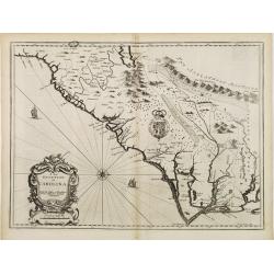
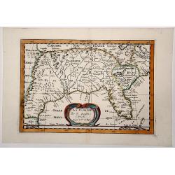
A new description of Carolina.
A wonderful map of Carolina. Incorporated into a 1676 reissue of Speed's 'Prospect Of The Most Famous Parts Of The World'. The map is (in)famous for its depiction of the ...
Date: London, 1676
Selling price: ????
Please login to see price!
Sold in 2021
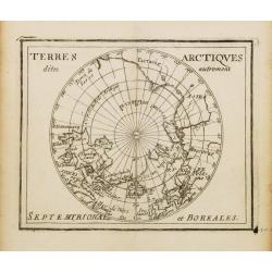
Terres Arctiques.. Septemtrional et Boreales.
Uncommon miniature map of the North Pole, including Iceland, the coast of Russia, Greenland, etc, from Pierre Duval's La Geographie Universeille dated 1676. Following his...
Date: Paris, 1676
Selling price: ????
Please login to see price!
Sold
La Floride.
Uncommon miniature map of Florida from Pierre Duval\'s La Geographie Universeille dated 1676. Following his Cartes de geographie in 1657, Pierre Duval published this smal...
Date: Paris, 1676
Selling price: ????
Please login to see price!
Sold in 2008
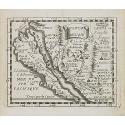
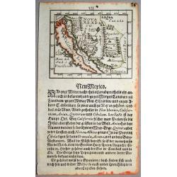
Noweau Mexique.
Uncommon miniature map of New Mexico from Pierre Duval\'s La Geographie Universeille. Following his Cartes de geographie in 1657, Pierre Duval published this smaller size...
Date: Paris, 1676
Selling price: ????
Please login to see price!
Sold in 2008
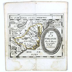
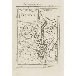
Carte de La Virginie.
Uncommon miniature map of Virginia from Pierre Duval\'s La Geographie Universeille dated 1676. It depicts the now defeated Swedish colony, and the inactive French claim o...
Date: Paris, 1676
Selling price: ????
Please login to see price!
Sold in 2008
Poli Arctici, et circumiacentium terrarum descriptio novissima. . .
A re-issue of the Hondius' plate, but without the signature. A particularly decorative map of the North Pole. Several Dutch names in Labrador. The toponymy in Canada refl...
Date: Amsterdam, ca.1676
Selling price: ????
Please login to see price!
Sold in 2016
Carte de La Virginie.
Uncommon miniature map of Virginia from Pierre Duval's La Geographie Universeille dated 1676. It depicts the now defeated Swedish colony, and the inactive French claim of...
Date: Paris, 1676
Selling price: ????
Please login to see price!
Sold
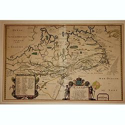
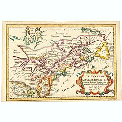
Le Canada faict par le St. de Champlain..
The fourth printed state of Champlain's 1616 plate of Canada. According to Wroth, Du Val somehow came into possession of the Champlain plate, printed a proof state, then ...
Date: Paris, 1677
Selling price: ????
Please login to see price!
Sold in 2012
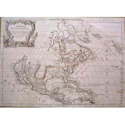
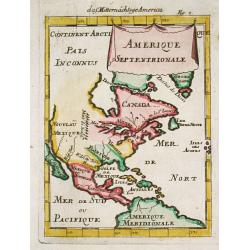
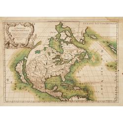
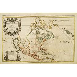
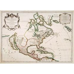
L'America Settentrionale.
Full title: 'L' America Settentrionale. Nuouamente corretta, et accresciuta secondo le relationi piu moderne, da GVGLIELMO SANSONE Geografe di S M Chrisftianis. E data in...
Date: Rome, 1677
Selling price: ????
Please login to see price!
Sold in 2015
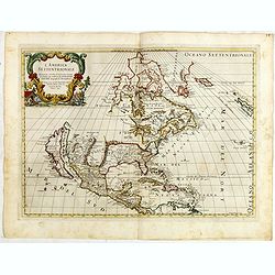
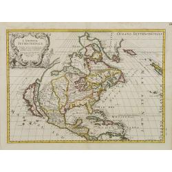
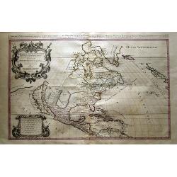
L' America Settentrionale. Nuouamente corretta, et accresciuta secondo le relationi piu moderne, da GVGLIELMO SANSONE. . .
Rossi's map of North America, based upon Sanson's seminal map, but with revised Italian nomenclature. Includes a detailed California as an Island on Sanson's model, and e...
Date: Rome, 1677
Selling price: ????
Please login to see price!
Sold in 2015
Florida.
Uncommon derivate of this miniature map of Louisiana and Florida. Similar to the map in Pierre Duval's La Geographie Universeille, which was derived from La Floride , 165...
Date: Nuremberg 1678
Selling price: ????
Please login to see price!
Sold
Virginia.
Uncommon derivate of this miniature map of Virginia, earlier published in Pierre Duval's La Geographie Universeille. It depicts the now defeated Swedish colony, and the i...
Date: Nuremberg 1678
Selling price: ????
Please login to see price!
Sold
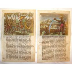
Florida (Two Copper Engravings)
Two Very interesting hand-colored copper engravings featuring Native American in Florida. One is titled ""Native Americans Walk Through Forest" and the oth...
Date: Amsterdam, 1679
Selling price: ????
Please login to see price!
Sold in 2013
LA FLORIDE
Map of Florida, from the atlas L'Amérique en plusieurs cartes, et en divers traittés de Géographie, et d'Histoire.Nicolas Sanson was to bring about the rise of French ...
Date: Paris 1680
Selling price: ????
Please login to see price!
Sold in 2019
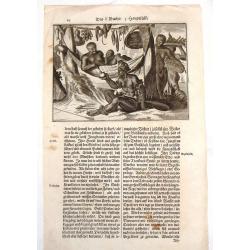
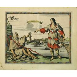
American Family at Rest.
Interesting map of a Native American family at rest. It gives an indication of dress, foods and customs. Olfert Dapper (1635 – 1689) was a Dutch physician and write...
Date: Amsterdam, 1681
Selling price: ????
Please login to see price!
Sold in 2015
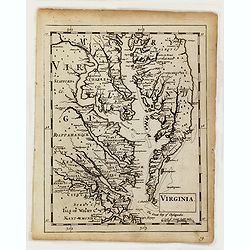
Virginia.
Uncommon map of Virginia, printed by A. Godbid and J. Playford, for R. Scott. Included in "New systeme of the mathematicks: containing . . . II. Practical geometry. ...
Date: London, 1681
Selling price: ????
Please login to see price!
Sold
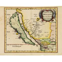
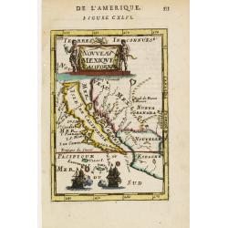
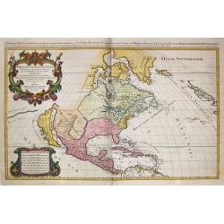
Audience de Guadalajara nouveau Mexique, Californie. &c.
From Sanson's Geographia Exactissima. A finely re-engraved Amsterdam version of Sanson's map of California and New Mexico, first published in 1657, which was the earliest...
Date: Amsterdam 1682
Selling price: ????
Please login to see price!
Sold
Floride.
Includes much of the Southern States.By Allain Manneson Mallet (1630-1706), a well travelled military engineer and geographer who worked in 17th century France under King...
Date: Paris 1683
Selling price: ????
Please login to see price!
Sold
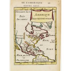
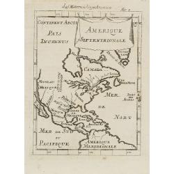
Amerique Septentrionale.
A charming late 17th-century French map of North America, showing California to 40 degrees North and labelled I.Calfornie.
Date: Paris 1683
Selling price: ????
Please login to see price!
Sold
St. Augus. De Floride.
Handsome view of the St. Augustine on the coast of Florida.From the French text edition of Description d'Univers, 1683. by Allain Manneson Mallet (1630-1706), a well trav...
Date: Paris 1683
Selling price: ????
Please login to see price!
Sold

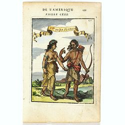
P.les de la Floride.
Attractive copper engraving, depicting a couple of native people of Florida.From the French text edition of Description d'Univers, 1683. by Allain Manneson Mallet (1630-1...
Date: Paris 1683
Selling price: ????
Please login to see price!
Sold
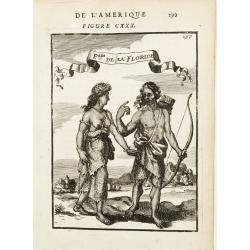
P.les de la Floride.
Attractive copper engraving, depicting a couple of native people of Florida.From the French text edition of Description d'Univers, 1683. by Allain Manneson Mallet (1630-1...
Date: Paris 1683
Selling price: ????
Please login to see price!
Sold
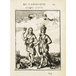
P.les de Virginie.
Attractive copper engraving, depicting a couple of native people of Florida.From the French text edition of Description d'Univers, 1683. by Allain Manneson Mallet (1630-1...
Date: Paris 1683
Selling price: ????
Please login to see price!
Sold
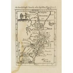
Canada ou Nouvelle France.
A charming late 17th century French map of east coast of Canada and North America.Greenland drawn close to the Canadian coast. The Great Lakes are shown open-ended in the...
Date: Paris, 1683
Selling price: ????
Please login to see price!
Sold
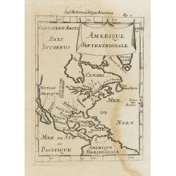
Amerique Septentrionale.
A charming late 17th century French map of North America, showing California to 40 degrees North and labelled I.Calfornie.
Date: Paris, 1683
Selling price: ????
Please login to see price!
Sold in 2008
Canada ou Nouvelle France. (together with) United States.
A strange early depiction of the Eastern Seaboard, from Terres Arctiques Incognues to Virginie, including also an outline of the Great Lakes. Native Indians appear at the...
Date: Paris, 1683
Selling price: ????
Please login to see price!
Sold in 2012
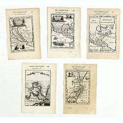
(Five maps of North American interest from Description de l'Univers)
Finely etched maps entitled : Nouveau Mexique et Californie, Mexique et nouvelle Espagne, Amerique Septentrionale, De l'Amerique, Groenlande".From the French text ed...
Date: Paris, 1683
Selling price: ????
Please login to see price!
Sold in 2015
P.les de la Floride.
Attractive copper engraving, depicting a couple of native people of Florida.
Date: Paris, 1683
Selling price: ????
Please login to see price!
Sold in 2016
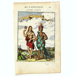
P.les de Virginie.
Attractive copper engraving, depicting a couple of native people of Virginia.From the French text edition of Description d'Univers, 1683. by Allain Manneson Mallet (1630-...
Date: Paris, 1683
Selling price: ????
Please login to see price!
Sold in 2025
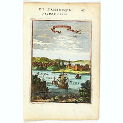
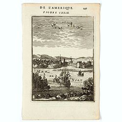
Sr. Augus. de Floride.
Attractive copper engraving, depicting a view of St. Augustine - the first European Settlement in North America.Shows the port, fortifications, sailing vessels and a fanc...
Date: Paris, 1683
Selling price: ????
Please login to see price!
Sold in 2016
![[ Pomeiocc, Virginia.]](/uploads/cache/36906-250x250.jpg)
[ Pomeiocc, Virginia.]
Attractive copper engraving, depicting a view of Pomeiocc, Virginia, with an inset of the interior of a Powhatan Lodge [ based on that of John Smith's map of Virginia].Fr...
Date: Paris, 1683
Selling price: ????
Please login to see price!
Sold in 2016
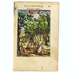
Hurons.
Attractive copper engraving, depicting Huron Indians or Wynadot / Wendat people hunting and gathering .
Date: Paris, 1683
Selling price: ????
Please login to see price!
Sold in 2016
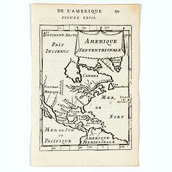
Amerique Septentrionale.
A charming map of North America showing only the island of California at about 40 degrees north. The Great Lakes are open-ended in the west and called Mer Douce and there...
Date: Paris, 1683
Selling price: ????
Please login to see price!
Sold in 2020
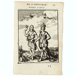
Ples. De Virginie.
A charming print depicting a male and female figure from the state of Virginia. Title in curtain draped at top. French text on verso.From the original 1683 text edition ...
Date: Paris, 1683
Selling price: ????
Please login to see price!
Sold in 2022
St Angus de Floride. (St. Augustine, Florida)
A charming view of St. Augustine, Florida. Title in curtain draped at top. French text on verso.From the original 1683 text edition of "Description d'Univers. . .&q...
Date: Paris, 1683
Selling price: ????
Please login to see price!
Sold in 2020
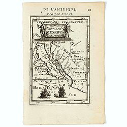
Nouveau Mexique et Californie.
A charming map of California as an Island. The title cartouche is flanked by two native figures and two ships engaged in battle at the bottom. Title in a curtain draped a...
Date: Paris, 1683
Selling price: ????
Please login to see price!
Sold in 2020
Floride
Rare 17the century copper engraved map of Florida from Allain Manesson Mallet's Description De L' Univers, Contenant Les Differents Systemes Du Monde, Les Cartes generale...
Date: Paris, 1683
Selling price: ????
Please login to see price!
Sold in 2023
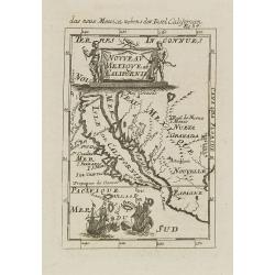
Nouveau Mexique et Californie.
A charming late 17th century French map of California, Nueva Granada and Nouvelle Espagne. California with flat northern coast, labelled Isle de Calfornie. A unique proje...
Date: Franckfurt 1684
Selling price: ????
Please login to see price!
Sold
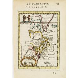
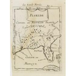
Floride.
A charming late 17th century French map of Florida, Virginia, Louisiana. Tegesta is the name given to the Florida peninsula.The map has little detail, Virginia is above t...
Date: Franckfurt 1684
Selling price: ????
Please login to see price!
Sold
Virginie.
Charming miniature map of the Chesapeake Bay region locating the colony at Jamestown and the village of Pomejok.Several Indian tribes named including Powhatan. Title in c...
Date: Franckfurt 1684
Selling price: ????
Please login to see price!
Sold
Nouveau Mexique et Californie.
A charming late 17th century French map of California, Nueva Granada and Nouvelle Espagne. California with flat northern coast, labelled Isle de Calfornie. A unique proje...
Date: Franckfurt 1684
Selling price: ????
Please login to see price!
Sold
Virginie.
Charming miniature map of the Chesapeake Bay region locating the colony at Jamestown and the village of Pomejok.Several Indian tribes named including Powhatan. Title in c...
Date: Frankfurt, 1684
Selling price: ????
Please login to see price!
Sold in 2008
Amerique Septentrionale.
A charming late 17th-century French map of North America, showing California to 40 degrees North and labeled I.Calfornie.From the German text edition published by Davis Z...
Date: Frankfurt, 1684
Selling price: ????
Please login to see price!
Sold in 2008
Canada ou Nouvelle France.
A strange early depiction of the Eastern Seaboard, from Terres Arctiques Incognues to Virginie, including also an outline of the Great Lakes. Native Indians appear at the...
Date: Frankfurt, 1684
Selling price: ????
Please login to see price!
Sold in 2008
Floride. / Das Landt Florida.
A charming late 17th century French map of Florida, Virginia, Louisiana. Tegesta is the name given to the Florida peninsula.The map has little detail, Virginia is above t...
Date: Frankfurt, 1684
Selling price: ????
Please login to see price!
Sold in 2008
Nouveau Mexique et Californie.
A charming late 17th century French map of California, Nueva Granada and Nouvelle Espagne. California with flat northern coast, labeled Isle de Calfornie. A unique projec...
Date: Frankfurt, 1684
Selling price: ????
Please login to see price!
Sold in 2008
Virginie.
Charming miniature map of the Chesapeake Bay region locating the colony at Jamestown and the village of Pomejok.Several Indian tribes named including Powhatan. Title in c...
Date: Frankfurt, 1684
Selling price: ????
Please login to see price!
Sold in 2008
Nouveau Mexique et Californie.
A charming late 17th century French map of California, Nueva Granada and Nouvelle Espagne. California with flat northern coast, labeled Isle de Calfornie. A unique projec...
Date: Frankfurt, 1684
Selling price: ????
Please login to see price!
Sold in 2008
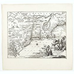
Novi Belgii Novaeque Angliae nec non partis Virginiae tabula : multis in locis emendata / per Nicolaum Visscher.
An essential map of the New Netherlands, New England, Pennsylvania, and parts of Maryland and Virginia. Although the map itself is primarily derived from Joannes Janssoni...
Date: Amsterdam, 1684
Selling price: ????
Please login to see price!
Sold in 2014
Amerique Septentrionale.
Alain Manneson Mallet (1603-1706) published in 1683 his ' Description de l' Univers' in 5 volumes. In 1686 a German edition appeared.Allain Mallet's attractive little map...
Date: Frankfurt, 1686
Selling price: ????
Please login to see price!
Sold in 2008
L'America Settentrionale..
Second edition of Rossi's map of North America, based upon Sanson's seminal map, but with revised Italian nomenclature. From Rossi's Mercurio Geographico..Includes a deta...
Date: Rome 1687
Selling price: ????
Please login to see price!
Sold
L'America Settentrionale. Nuovamente Corretta et Accresciuta Secondo le Relationi Piu Moderne da Guglielmo Sansone Geografo ...
Second edition of Rossi's map of North America, based upon Sanson's seminal map, but with revised Italian nomenclature. From Rossi's Mercurio Geographico..Includes a deta...
Date: Rome, 1687
Selling price: ????
Please login to see price!
Sold in 2012
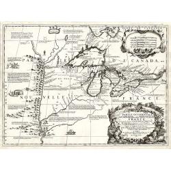
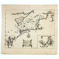
Partie Occidentale du Canada ou de la Nouvelle France...
A very rare map of the Great Lakes by Coronelli / Nolin and one of the most beautiful, acquirable works to focus on the region. As Tooley states, ?it was the best represe...
Date: Paris, 1688
Selling price: ????
Please login to see price!
Sold
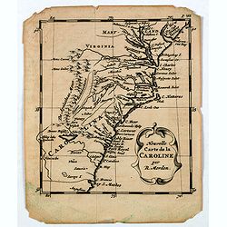
Nouvelle Carte de la CAROLINE.
A scarce small map of Carolina by the English cartographer Robert Morden. Scarce early edition of Abraham Wofgang's Amsterdam edition of Morden's map of the Carolina, one...
Date: Amsterdam, 1688
Selling price: ????
Please login to see price!
Sold in 2020
Nouvelle Carte de la Pensylvanie Maryland Virginia et Nouvelle Jarsey.
A scarce edition of this early map of the east coast region centered on New York and the Chesapeake and Delaware, from Abraham Wolfgang's L'Amerique Angloise, ou Descript...
Date: Amsterdam, 1688
Selling price: ????
Please login to see price!
Sold in 2020
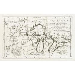
La Lovisiana, Parte Settentrionalle, Scoperta sotto la Protettione di Luigi XIV, Rè di Francia..
One of the most important maps of the Great Lakes and Upper Mississippi, based upon reports of La Salle, Hennepin, Marquette, Jolliet and other French Jesuits who were ac...
Date: Venice 1690
Selling price: ????
Please login to see price!
Sold
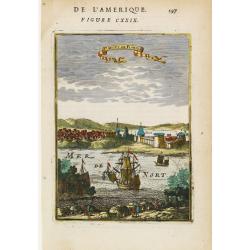
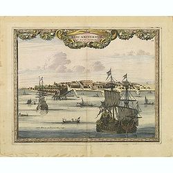
Nieu Amsterdam al. New York.
Engraved by Aldert Meyer for Carolus Allard's for his Orbis habitabilis oppida et vestitus the print shows two locals and a distance view of lower Manhattan. This rare wo...
Date: Amsterdam, c.1685-1690
Selling price: ????
Please login to see price!
Sold in 2010
Nieu Amsterdam al. New York.
Engraved by Thomas Doesburgh (active between 1683 and 1714) for Carolus Allard's for his Orbis habitabilis oppida et vestitus the print shows a distance view of lower Man...
Date: Amsterdam, c.1685-1690
Selling price: ????
Please login to see price!
Sold in 2011
Amerique septentrionale.
Engraved by Cordier. Spectacular example of Jaillot's map of North America, showing California as an Island, based upon Sanson's landmark map of 1656. This map shows the ...
Date: Paris, 1692
Selling price: ????
Please login to see price!
Sold
Amerique Septentrionale divisée en ses principales parties?
Impressive map of North America, prepared by Nicolas Sanson and published by Pierre Mortier in Amsterdam. The map is copied from Jaillot's map of 1674 and only some small...
Date: Amsterdam, 1692
Selling price: ????
Please login to see price!
Sold in 2008
The Island of California.
A rare miniature map focusing on the large Island of California, in original outline color. An example of the first state. Inaccurately and extensively detailed with moun...
Date: Ulm, 1692
Selling price: ????
Please login to see price!
Sold in 2017
![[Florida]](/uploads/cache/40498-250x250.jpg)
[Florida]
A rare regional American map, published by Johann Ulrich Muller. A highly coveted and most collectable miniature map of Florida, the Gulf Coast, Texas, the Mississippi Va...
Date: Ulm, 1692
Selling price: ????
Please login to see price!
Sold in 2017
![[Neu Mexico]](/uploads/cache/40499-250x250.jpg)
[Neu Mexico]
A rare miniature map of California and Nova Mexico, published by Johann Ulrich Muller in Ulm .This attractive map shows the island of California and the contiguous parts ...
Date: Ulm, 1692
Selling price: ????
Please login to see price!
Sold in 2018
![[Neu Mexico]](/uploads/cache/43923-250x250.jpg)
[Neu Mexico]
A rare miniature map of California and Nova Mexico, published by Johann Ulrich Muller in Ulm .This attractive map shows the island of California and the contiguous parts ...
Date: Ulm, 1692
Selling price: ????
Please login to see price!
Sold in 2020
Le Canada, ou Nouvelle France, &c, tiree de diverses Relations des Francois, Anglois, Hollandois, &c. . .
A fine smaller map of the north eastern US seaboard, extending to the Great Lakes (shown as open-ended) and beyond into 'Upper Canada' by Nicolas Sanson, and originally f...
Date: Utrecht, 1692
Selling price: ????
Please login to see price!
Sold in 2021

Belgii novi, angliae novae, et partis Virginiae . . .
This example is state 3 of the original Janssonius plate, printed after Schenk acquired the plates at public auction in 1694 from the heirs of Jansson van Waesberge. The ...
Date: Amsterdam, 1694
Selling price: ????
Please login to see price!
Sold in 2025
Amérique septentrionale divisée en ses principales parties..
Engraved by Cordier. Spectacular example of Jaillot's map of North America, showing California as an Island, based upon Sanson's landmark map of 1656. This map shows the ...
Date: Paris, 1695
Selling price: ????
Please login to see price!
Sold
Amerique septentrionale / divisee en ses principales parties. Paris, 1695.
Alexis-Hubert Jaillot (1632-1712), French cartographer. He joined the Sanson heirs and redrew Nicolas Sanson's maps on a larger scale. 'Atlas Nouveau' (1674), sea-atlas '...
Date: Amsterdam, 1696
Selling price: ????
Please login to see price!
Sold
L'Amérique septentrionale et les terres polaires arctique (sic) / dressée par N. de Fer.
An interesting small map of North America by Nicolas de Fer. From his rare "Petit et Nouveau Atlas". The first edition was published in 1697 and was republished...
Date: Paris,1697
Selling price: ????
Please login to see price!
Sold in 2016
Carte d'un Nouveau Monde, entre le Nouveau Mexique et la Mer Glaciale ...
Map of America from Nouveau Voyage d'un Pays plus grand que l'Europe ... by R. P. Louis Hennepin, published in Utrecht in 1698.Based on his 1683 map Carte de la Nouvelle ...
Date: Utrecht, 1698
Selling price: ????
Please login to see price!
Sold in 2014
Nouveau Voyage d'un Pais Plus Grand que l'Europe.
FIRST EDITION OF THE BOOK. This edition of Hennepin's writings, a continuation of his Nouveau voyage of the previous year, comprises materials about La Salle taken from C...
Date: Utrecht, [E. Voskuyl for] Antoine Schouten, 1698
Selling price: ????
Please login to see price!
Sold
