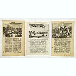
Browse Listings in America > North America
![[A truce between the Indians and the English].](/uploads/cache/41108-250x250.jpg)
[A truce between the Indians and the English].
Not having heard anything for some time from Powhatan, the English sailed again up the river with one hundred and fifty men, along with Powhatan’s daughter, to one of t...
Date: Frankfurt, M.Merian, 1633
Selling price: ????
Please login to see price!
Sold in 2018
![[Powhaton's daughter is abducted].](/uploads/cache/41109-250x250.jpg)
[Powhaton's daughter is abducted].
In 1613, Captain Argall managed to bribe some Indian friends of Pocahontas to visit his ship with them. When she was aboard, he kept her hostage and sailed back down rive...
Date: Frankfurt, M.Merian, 1633
Selling price: ????
Please login to see price!
Sold in 2018
![[John Smith is saved by Pocahontas].](/uploads/cache/41110-250x250.jpg)
[John Smith is saved by Pocahontas].
Within a few months of establishing the Jamestown colony in 1607, forty-six English had died from disease and starvation, so Smith went to try to obtain food from the Ind...
Date: Frankfurt, M.Merian, 1633
Selling price: ????
Please login to see price!
Sold in 2018
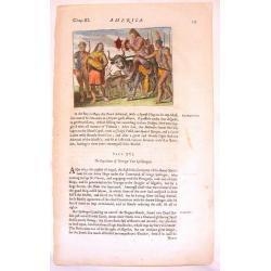
![[The massacre of Jamestown].](/uploads/cache/41118-250x250.jpg)
[The massacre of Jamestown].
A brutal and violent scene of native Indians massacring the new inhabitants of the recently established English colony of Jamestown in VA.In 1631 Johann Ludwig Gottfried,...
Date: Frankfurt, M.Merian, 1633
Selling price: ????
Please login to see price!
Sold in 2018
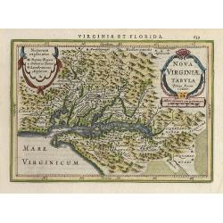
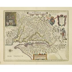
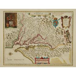
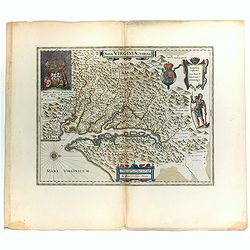
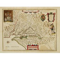
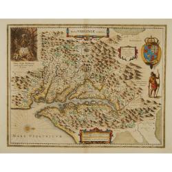
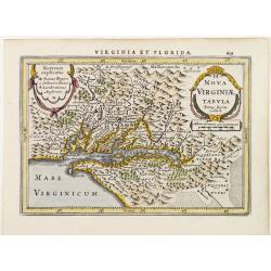
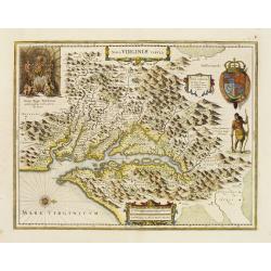
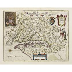
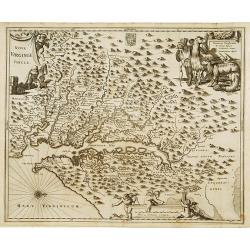
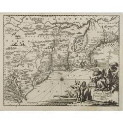
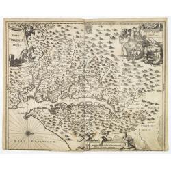
Nova Virginiae Tabula.
A decorative small version of John Smith's map of Chesapeake Bay region. It is the only regional map of North America to appear in the Atlas Minor. Engraved by Pieter van...
Date: Amsterdam 1634
Selling price: ????
Please login to see price!
Sold
![Insulae Americanae in Oceano Septentrionali, cum terris adjacentibus [Rare Blaeu West Indische Pascaert Wall Map Section]](/uploads/cache/36201-250x250.jpg)
Insulae Americanae in Oceano Septentrionali, cum terris adjacentibus [Rare Blaeu West Indische Pascaert Wall Map Section]
On 11 February 1634, Willem Blaeu announced the publication of a world atlas in four languages. He was able to complete only the German edition in that year. In order to ...
Date: Amsterdam, 1634
Selling price: ????
Please login to see price!
Sold in 2015
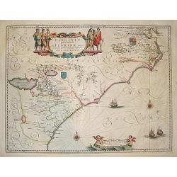
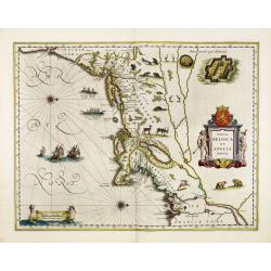
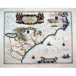
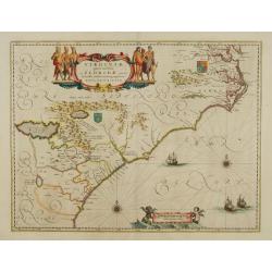
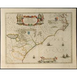
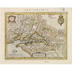
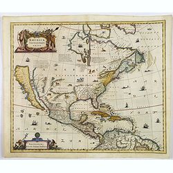
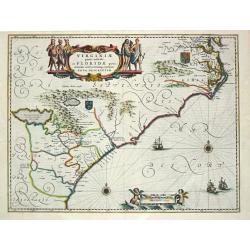
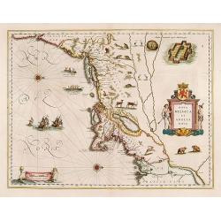
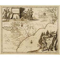
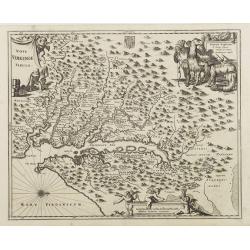
Virginiae Partis Australis, et Floridae Partis Orientalis.
This beautifully engraved map is based on the Mercator-Hondius work of 1606, with a significant number of geographic changes / improvements, particularly along the Caroli...
Date: Amsterdam, ca. 1635
Selling price: ????
Please login to see price!
Sold
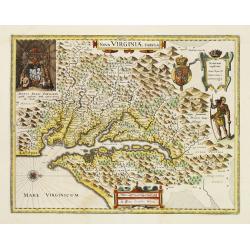
Nova Virginiae Tabula.
The map is based on the first state of Smith's map, 1612, and is slightly larger and more expertly engraved. In 1629 the Hondius plate was purchased by Blaeu who deleted ...
Date: Amsterdam 1635
Selling price: ????
Please login to see price!
Sold
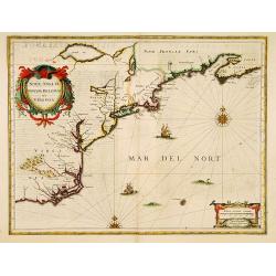
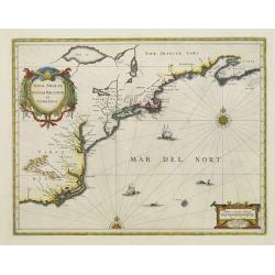
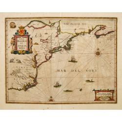
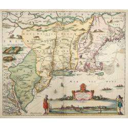
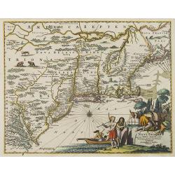
Nova Anglia Novum Belgium et Virginia.
In the 1636 edition of the Appendix , Johannes Janssonius inserted this important and influential map of the eastern seaboard from C. of Feare (Cape Look out) to Nova Sco...
Date: Amsterdam, 1636
Selling price: ????
Please login to see price!
Sold in 2019
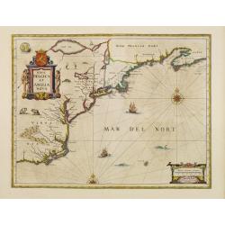
Nova Anglia Novum Belgium et Virginia.
In the 1636 edition of the Appendix , Johannes Janssonius inserted this important and influential map of the eastern seaboard from C. of Feare (Cape Look out) to Nova Sco...
Date: Amsterdam 1636
Selling price: ????
Please login to see price!
Sold
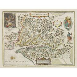
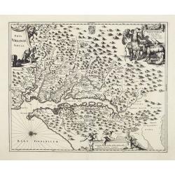
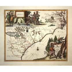
Nova Virginiae Tabula.
One of the most important maps of the Chesapeake Bay region, credited with disseminating knowledge of the English settlement in Virginia throughout Europe in the 17th cen...
Date: Amsterdam, ca. 1636
Selling price: ????
Please login to see price!
Sold
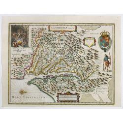
Nova Virginiae Tabula.
One of the most important maps of the Chesapeake Bay region, credited with disseminating knowledge of the English settlement in Virginia throughout Europe in the 17th cen...
Date: Amsterdam, ca. 1636
Selling price: ????
Please login to see price!
Sold in 2022
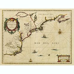
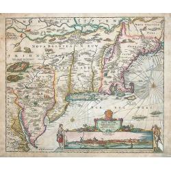
Nova Anglia Novum Belgium et Virginia.
In the 1636 edition of the "Appendix," Johannes Janssonius inserted this critical and influential map of the eastern seaboard from C. of Feare (Cape Lookout) to...
Date: Amsterdam, 1636
Selling price: ????
Please login to see price!
Sold in 2021
Nova Virginiae Tabula.
The map is based on the first state of Smith's map, 1612, and is slightly larger and more expertly engraved. In 1629 the Hondius plate was purchased by Blaeu who deleted ...
Date: Amsterdam, 1638
Selling price: ????
Please login to see price!
Sold

Nova Belgica et Anglia Nova.
Orientated with north to the right. This is one of the earliest maps to concentrate solely on this area of the colonies, excluding Virginia and the extreme north east coa...
Date: Amsterdam, 1638
Selling price: ????
Please login to see price!
Sold in 2010
Nova Belgica et Anglia Nova.
Orientated with north to the right. This is one of the earliest maps to concentrate solely on this area of the colonies, excluding Virginia and the extreme north east coa...
Date: Amsterdam, 1638
Selling price: ????
Please login to see price!
Sold in 2013
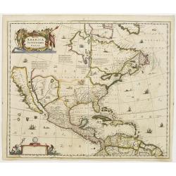
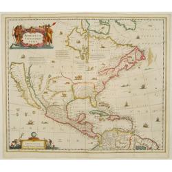
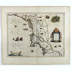
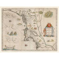
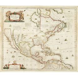
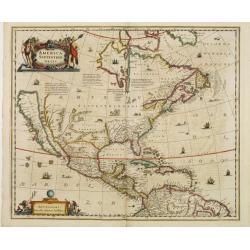
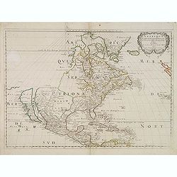
America septentrionalis.
A first state of this important map showing California as an island. Lacking any imprint in the cartouche, lower left. From the first French text edition. The north-west ...
Date: Amsterdam 1639
Selling price: ????
Please login to see price!
Sold
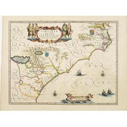
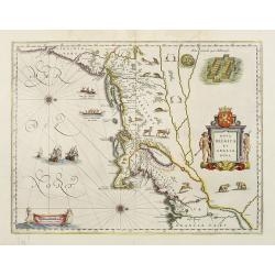
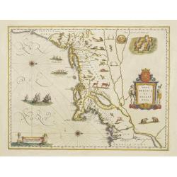
Virginiae Partis australis, et Floridae partis orientalis, interjacentiumqs regionum Nova Descriptio
Important map of the East Coast, from the Chesapeake Bay to Georgia with numerous early place names including Jamestown, Cape Fear, and Newport News. Two coat of arms ill...
Date: Amsterdam, 1639
Selling price: ????
Please login to see price!
Sold in 2016
Nova Virginiae Tabula.
The map is based on the first state of Smith's map, 1612, and is slightly larger and more expertly engraved. In 1629 the Hondius plate was purchased by Blaeu who deleted ...
Date: Amsterdam 1640
Selling price: ????
Please login to see price!
Sold
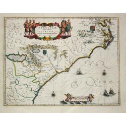
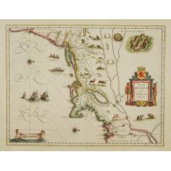
Virginiae Partis Australis, et Floridae Partis Orientalis.
Blaeu based this map on the Mercator-Hondius of 1606. A number of geographical improvements, however were incorporated, although two large fictions lakes accompanied by e...
Date: Amsterdam 1640
Selling price: ????
Please login to see price!
Sold
America Septentrionalis.
Showing California as an island, and above, the north west of the continent left blank except for two legends explaining the discoveries to that date. The Hudson Bay is c...
Date: Amsterdam 1640
Selling price: ????
Please login to see price!
Sold
Virginiae Partis Australis, et Floridae Partis Orientalis.
Blaeu based this map on the Mercator-Hondius of 1606. A number of geographical improvements, however were incorporated, although two large fictions lakes accompanied by e...
Date: Amsterdam 1640
Selling price: ????
Please login to see price!
Sold
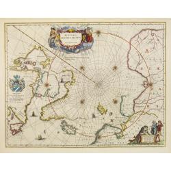
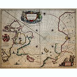
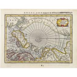
Regiones Sub Polo Arctico.
One of the many cases of duplication by the firms of Blaeu and Hondius/Jansson. In this case, Blaeu has copied Jansson's map of 1637. It depicts rhumb lines radiating fro...
Date: Amsterdam, 1640
Selling price: ????
Please login to see price!
Sold in 2009
Nova Belgica et Anglia Nova.
Orientated with north to the right. This is one of the earliest maps to concentrate solely on this area of the colonies, excluding Virginia and the extreme north east coa...
Date: Amsterdam, 1640
Selling price: ????
Please login to see price!
Sold in 2017
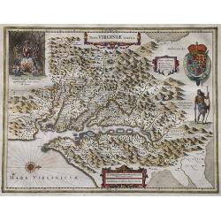
Nova Virginiae Tabula.
Blaeu's beautiful map of Virginia, Maryland and the Chesapeake Bay region on North America's eastern seaboard. It shows the discoveries in the area as detailed by John Sm...
Date: Amsterdam, ca 1640
Selling price: ????
Please login to see price!
Sold in 2022
Nova Belgica Et Anglia Nova
An important and early colonial era map of the Dutch and English colonies of northeast America by the renowned 17th century map maker, Willem Janszoon Blaeu. The map is d...
Date: Amsterdam, 1640
Selling price: ????
Please login to see price!
Sold in 2023
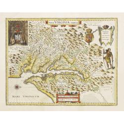
Nova Virginia Tabula.
Early map of Virginia. Being Henricus Hondius' derivative of John Smith's highly important map of Virginia, 1612. Orientation west to top.Title in an Antwerp style cartou...
Date: 1641
Selling price: ????
Please login to see price!
Sold in 2019
Nova Virginiae Tabula.
The map is based on the first state of Smith's map, 1612, and is slightly larger and more expertly engraved. In 1629 the Hondius plate was purchased by Blaeu who deleted ...
Date: Amsterdam, 1642
Selling price: ????
Please login to see price!
Sold
Virginiae Partis australis, et Floridae Partis Orientalis, interjacentiumq, regionum Nova Descripti
Attractive map of the east coast of Virginia and Florida. Second state with small tail at left water-cherub. "One of the many elegantly engraved maps of the Eastern ...
Date: Amsterdam, 1643
Selling price: ????
Please login to see price!
Sold in 2009
Description de la Nouvelle France ou sont remarquees les diverse habitations des Francois, depuis la premiere descouvert jusques a present, recueillie et dressee sur diverses relations modernes
VERY RARE FIRST STATE, a second state was issued circa 1664. In superb condition. Important GREAT LAKES map first issued in 1643. According to Burden it is actually the f...
Date: Paris, 1643
Selling price: ????
Please login to see price!
Sold in 2012
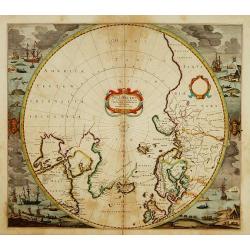
Poli Arctici et Circumiacentium Terrarum Descriptio.
A circular map showing north of Europe and United States. The map is surrounded by scenes of fishing whales.
Date: Amsterdam 1639-1644
Selling price: ????
Please login to see price!
Sold
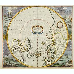
Poli Arctici et Circumiacentium Terrarum Descriptio.
A circular map showing north of Europe and United States. The map is surrounded by scenes of fishing whales. Cartographically the map incorporates much of the knowledge g...
Date: Amsterdam, 1639-1644
Selling price: ????
Please login to see price!
Sold in 2012
Nova Virginiae Tabula.
The map is based on the first state of Smith's map, 1612, and is slightly larger and more expertly engraved. In 1629 the Hondius plate was purchased by Blaeu who deleted ...
Date: Amsterdam 1645
Selling price: ????
Please login to see price!
Sold
America Septentrionalis.
Showing California as an island, and above, the north west of the continent is left blank except for two legends explaining the discoveries to that date. The Hudson Bay i...
Date: Amsterdam 1647
Selling price: ????
Please login to see price!
Sold
Nova Virginiae Tabula.
The map is based on the first state of Smith's map, 1612, and is slightly larger and more expertly engraved.The map is, in part, famous for its depiction, upper left, of ...
Date: Amsterdam 1647
Selling price: ????
Please login to see price!
Sold
America Septentrionalis.
Showing California as an island, and above, the north west of the continent is left blank except for two legends explaining the discoveries to that date. The Hudson Bay i...
Date: Amsterdam 1647
Selling price: ????
Please login to see price!
Sold
Regiones Sub Polo Arctico.
A fine Blaeu version of the Janssonius map of 1637. It depicts rhumb lines radiating from the North Pole. A large title cartouche, with two figures and numerous wind head...
Date: Amsterdam, 1647
Selling price: ????
Please login to see price!
Sold in 2017
Virginia.
Detailed miniature map of Virginia, from a German text edition of his Atlas Minor. Engraved by Petrus Kaerius.
Date: Amsterdam (1628) 1648
Selling price: ????
Please login to see price!
Sold
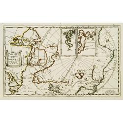
Septentrionalium Terrarum Descript.
Detailed miniature map of the North Pole, from a German text edition of his Atlas Minor. Engraved by Petrus Kaerius.
Date: Amsterdam (1628) 1648
Selling price: ????
Please login to see price!
Sold
Nova Virginiae Tabula..
Detailed miniature map of Virginia, from a German text edition of his Atlas Minor. Engraved by Petrus Kaerius.
Date: Amsterdam (1628) 1648
Selling price: ????
Please login to see price!
Sold
Nova Belgica et Anglia Nova.
A second state. Derived from De Laet's map of 1630, which was important as the first appearance on a printed map of 'Manhattes' (Manhattan), 'N.Amsterdam' (New York, foun...
Date: Amsterdam 1649
Selling price: ????
Please login to see price!
Sold
Nova Belgica et Anglia Nova.
A second state. Derived from De Laet's map of 1630, which was important as the first appearance on a printed map of 'Manhattes' (Manhattan), 'N.Amsterdam' (New York, foun...
Date: Amsterdam 1649
Selling price: ????
Please login to see price!
Sold
Nova Virginiae Tabula.
The map is based on the first state of Smith's map, 1612, and is slightly larger and more expertly engraved. In 1629 the Hondius plate was purchased by Blaeu who deleted ...
Date: Amsterdam 1638-1649
Selling price: ????
Please login to see price!
Sold
Pais qui dependent de la Norvege suivant les derniers relations.
Rare map of the North Pole. With inset maps of Faeroe and Shetland Islands.
Date: Paris 1650
Selling price: ????
Please login to see price!
Sold
Amerique Septentrionale par N. Sanson.
Decorative and important map of the Americas with a CALIFORNIA AS AN ISLAND. Engraved by Abraham Peyrounim (c.1620 - c.1666).Sanson's map of North America is the first to...
Date: Paris, after 1650
Selling price: ????
Please login to see price!
Sold in 2014
America Septentrionalis.
A wonderful map showing California as an island, and above, the northwest of the continent is left blank except for two paragraphs explaining the discoveries to date. Int...
Date: Amsterdam, ca 1650
Selling price: ????
Please login to see price!
Sold in 2019
Nouvelle Description de l´Amerique
Extremely rare mid 17th century French map of North and South America (and Antarctica) by the French cartographer Tassin. Published in Paris by Berey in 1651 in ´Carte g...
Date: Paris, 1651
Selling price: ????
Please login to see price!
Sold in 2023
Novi Belgii novae que Angliae nec non partis Virginiae..
The very rare second state: with Fort Kassimier, but without Philadelphia. A classic Dutch map of the east coast from the Chesapeake Bay north to Canada with the famous v...
Date: Amsterdam 1652
Selling price: ????
Please login to see price!
Sold
Novi Belgii novaeque Angliae nec non partis Virginiae tabula multis in locis emendata a Iusto Dackers.
This map belongs to the most famous maps of New England. It shows the East coast from the Chesapeake to the St. Lawrence river. The map was firstly published by J. Dancke...
Date: Amsterdam, 1655
Selling price: ????
Please login to see price!
Sold in 2014

Sir Francis Drake crowned King of California.
Rare 1655 view of Sir Francis Drake, English soldiers paraded and planting the flag while native Californians celebrate and place a crown on Drake's head. From "Newe...
Date: Frankfurt, 1655
Selling price: ????
Please login to see price!
Sold in 2015
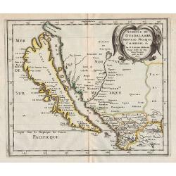
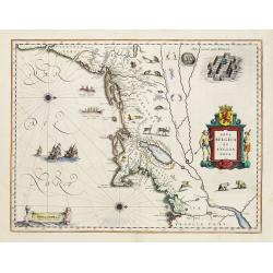
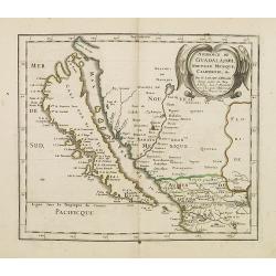
Audience de Guadalajara, Nouveau Mexique, Californie, &c.
Map of California, shown as an island, from the first edition of the atlas L'Amérique en plusieurs cartes, et en divers traittés de Géographie, et d'Histoire.Nicolas S...
Date: Paris, 1657
Selling price: ????
Please login to see price!
Sold in 2012
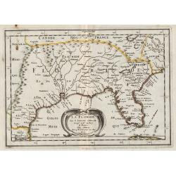
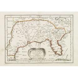
La Floride.
Map of Florida, from the first edition of the atlas L'Amérique en plusieurs cartes, et en divers traittés de Géographie, et d'Histoire.Nicolas Sanson was to bring abou...
Date: Paris, 1657
Selling price: ????
Please login to see price!
Sold in 2013
Virginiae partis australis et Floridae paertis orientalis, interjacentiumq3 regionum Nova Descriptio.
Johannes Janssonius, the great rival of Willem Blaeu, was the son-in-law of Jodocus Hondius. Together with Jodocus' son Hendrick, he continued to publish the successive e...
Date: Amsterdam, 1647-1658
Selling price: ????
Please login to see price!
Sold
Virginiae partis australis et Floridae paertis orientalis, interjacentiumq regionum Nova Descriptio.
Johannes Janssonius, the great rival of Willem Blaeu, was the son-in-law of Jodocus Hondius. Together with Jodocus' son Hendrick, he continued to publish the successive e...
Date: Amsterdam, 1647-1658
Selling price: ????
Please login to see price!
Sold in 2017
Nova Belgica et Anglia Nova.
Orientated with north to the right. This is one of the earliest maps to concentrate solely on this area of the colonies, excluding Virginia and the extreme north east coa...
Date: Amsterdam, 1658
Selling price: ????
Please login to see price!
Sold
Nova Virginiae Tabula.
The map is based on the first state of Smith's map, 1612, and is slightly larger and more expertly engraved. In 1629 the Hondius plate was purchased by Blaeu who deleted ...
Date: Amsterdam, 1658
Selling price: ????
Please login to see price!
Sold
Nova Belgica et Anglia Nova.
Orientated with north to the right. This is one of the earliest maps to concentrate solely on this area of the colonies, excluding Virginia and the extreme north east coa...
Date: Amsterdam, 1658
Selling price: ????
Please login to see price!
Sold
Nova Belgica et Anglia Nova.
Orientated with north to the right. This is one of the earliest maps to concentrate solely on this area of the colonies, excluding Virginia and the extreme north east coa...
Date: Amsterdam 1661
Selling price: ????
Please login to see price!
Sold
Nova Belgica et Anglia Nova.
Orientated with north to the right. This is one of the earliest maps to concentrate solely on this area of the colonies, excluding Virginia and the extreme north east coa...
Date: Amsterdam 1661
Selling price: ????
Please login to see price!
Sold
Nova Belgica et Anglia Nova.
Orientated with north to the right. This is one of the earliest maps to concentrate solely on this area of the colonies, excluding Virginia and the extreme north east coa...
Date: Amsterdam 1661
Selling price: ????
Please login to see price!
Sold
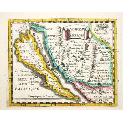
Nouveau Mexique.
Piere du Val (1618-83), Paris-based cartographer and publisher. Atlases a.o. 'Cartes de Géographie', 1654-88, 'La Géographie universelle', 1661-1712. After his death, h...
Date: Paris, 1661.Paris, 1661
Selling price: ????
Please login to see price!
Sold in 2008
![Pascaerte van NOVA HISPANIA PERV en CHILI [California as an island].](/uploads/cache/97818-250x250.jpg)
Pascaerte van NOVA HISPANIA PERV en CHILI [California as an island].
California as an island on second Sanson model, with indented northern coast. Agubela de Cato is peninsula to its north.Possibly copied from Blaeu's map of 1648, as was D...
Date: Amsterdam, 1666
Selling price: ????
Please login to see price!
Sold in 2020
Audience de Guadalajara nouveau Mexique, Californie. &c.
A finely engraved map of California and New Mexico. Prior to this map, all maps with California shown as an Island were either World maps, Western Hemisphere, North Ameri...
Date: Paris, P. Marriete, 1667
Selling price: ????
Please login to see price!
Sold in 2016
La Floride . . .
Map of Florida prepared by N.Sanson and published by Pierre Mariette.Published in an early edition of the small Sanson atlas L'Europe Dediée a Monseigneur . . . Le Telli...
Date: Paris, P. Mariette, 1667
Selling price: ????
Please login to see price!
Sold in 2008
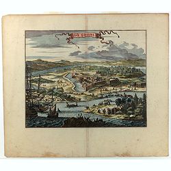
Novum Amsterodamum..
A good example of one of the earliest available views of New York, from Montanus description of America. Set in a folio page of text describing in glowing terms the attra...
Date: Amsterdam, 1671
Selling price: ????
Please login to see price!
Sold in 2011
Nova Virginia Tabula.
A beautifully engraved map, derived from the highly influential map by Captain John Smith in 1612, showing Chesapeake Bay and the surrounding area. The decoration of this...
Date: Amsterdam 1671
Selling price: ????
Please login to see price!
Sold
Virginiae partis australis, et Floridae partis orientalis..
A beautifully engraved map, derived from the highly influential maps by Mercator and later Blaeu. The decoration of this finely engraved map has two entirely new cartouch...
Date: Amsterdam 1671
Selling price: ????
Please login to see price!
Sold
Nova Virginia Tabula.
A beautifully engraved map, derived from the highly influential map by Captain John Smith in 1612, showing Chesapeake Bay and the surrounding area.The decoration of this ...
Date: Amsterdam, 1671
Selling price: ????
Please login to see price!
Sold
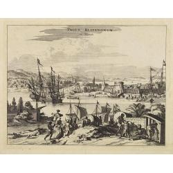
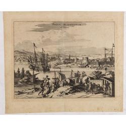
Pagus Hispanorum in Florida.
View of the port of St. Augustine, with ships and boats docked before the walled town, a few slaves and natives tending to their Spanish overlords.
Date: Amsterdam, 1671
Selling price: ????
Please login to see price!
Sold
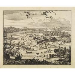
Arx Carolina.
View of the French settlement of Charles Fort, founded 1562 on Parris Island, Carolina, named after their king Charles IX.The garrison was captured three years later by t...
Date: Amsterdam, 1671
Selling price: ????
Please login to see price!
Sold
Novi Belgii quod nunc Novi Jorck..
A beautifully engraved map, derived from the highly influential map by Visscher. The decoration of this finely engraved map has in the lower right corner not longer a vie...
Date: Amsterdam, 1671
Selling price: ????
Please login to see price!
Sold
Nova Virginia Tabula.
A beautifully engraved map, derived from the highly influential map by Captain John Smith in 1612, showing Chesapeake Bay and the surrounding area.The decoration of this ...
Date: Amsterdam, 1671
Selling price: ????
Please login to see price!
Sold
Virginiae partis australis, et Floridae partis orientalis..
This striking map of the Southeast shows the French and English claims in the region marked with their respective coats of arms. The cartography in the southern part of t...
Date: London,1671
Selling price: ????
Please login to see price!
Sold in 2008
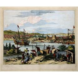
Pagus Hispanorum in Florida.
View of the port of St. Augustine, the oldest city in the United States and the northernmost bastion of the Spanish empire in America (Castillo de San Marcos). With ships...
Date: Amsterdam, 1671
Selling price: ????
Please login to see price!
Sold in 2020
Novi Belgii quod nunc Novi Jorck vocatur, Novae q. Angliae & partis Virginiae . . .
A beautifully engraved map, derived from the highly influential map by Visscher. The decoration of this finely engraved map has in the lower right corner not longer a vie...
Date: Amsterdam, 1671
Selling price: ????
Please login to see price!
Sold in 2008
PAGUS HISPANORUM in Florida
Ogilby’s important early view of St. Augustine. With very decorative coloring. This view was originally drawn from Gerrit van Schagen’s work, and depicts a fictional...
Date: London, 1671
Selling price: ????
Please login to see price!
Sold in 2011
Novum Amsterodamum. . . (together with 2 other scenes in New England)
A good example of one of the earliest available views of New York, from Montanus description of America, taken from a Dutch text edition. Set in a folio page of text desc...
Date: Amsterdam, 1671
Selling price: ????
Please login to see price!
Sold in 2014
Native Americans Bring Food & Water & Treasure.
Fine Historical hand-colored copperplate engraving featuring Native Americans bringing food and treasure. Arnoldus Montanus (1625–1683) was a Dutch teacher and aut...
Date: Amsterdam. 1671
Selling price: ????
Please login to see price!
Sold in 2013
Nova Virginia Tabula.
A beautifully engraved map, derived from the highly influential map by Captain John Smith in 1612, showing Chesapeake Bay and the surrounding area.The decoration of this ...
Date: Amsterdam, 1671
Selling price: ????
Please login to see price!
Sold in 2013
Arx Carolina.
A superb 17th century copperplate engraving displaying Fort Carole and its surrounds on the St. John's River in Florida. It is situated in what today is Jacksonville, in ...
Date: London, ca 1671
Selling price: ????
Please login to see price!
Sold in 2022

