Subscribe to be notified if similar examples become available.

Nova Belgica Et Anglia Nova |
||||||||||||||||||||
|
||||||||||||||||||||
|
|
||||||||||||||||||||
|
Selling price: $ Please login to see price!
Sold in 2023 Missed this item! Add your name to our mailing list and be the first to get notified about our newly added listings. . |
||||||||||||||||||||
Description
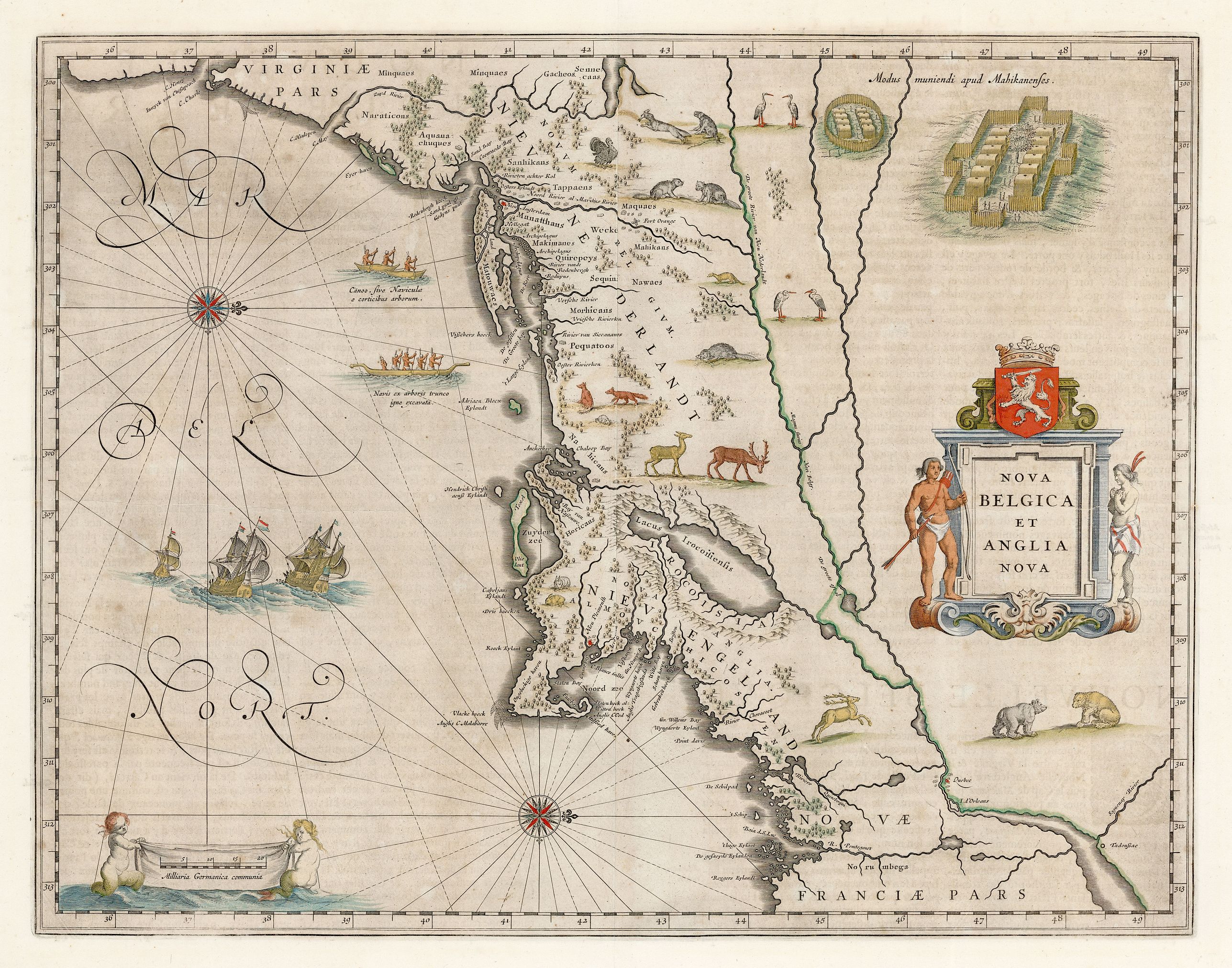
An important and early colonial era map of the Dutch and English colonies of northeast America by the renowned 17th century map maker, Willem Janszoon Blaeu. The map is derived from a manuscript map of the same area by Dutchman Adriaen Block, and from data accumulated by him and other early fur traders and explorers.
Block, an explorer, fur trader and entrepreneur, made four voyages to this region of North America soon after the exploratory voyages of Henry Hudson. His focus was the coastal region between Cape Cod and Manhattan. During his voyages he investigated a number of the estuaries in the area for the Dutch, who were interested in establishing trading posts in the Hudson River area. Block’s business acumen resulted in success in the fur trade and his powers of observation and talent in describing what he saw provided material for countless maps and accounts of the New World.
The map is oriented west and covers territory from as far north as Quebec to Virginia in the south. It is remarkably accurate, especially considering the limitations imposed by the instruments available for navigation and surveying in the early seventeenth century. The details of the coastline and various areas in the interior indicate exploration and discoveries of which there is relatively little other pictorial evidence dating to that period.
Indigenous peoples are named throughout the map, and two large, well-fortified villages are depicted in the upper right quadrant. Two canoes styled from hollowed out tree trunks are manned by indigenous crews, and three European vessels are represented at full sail. Wildlife abounds, and the luxurious depiction of flora and fauna makes this one of the most attractive decorative maps of this region of its time. Various species embellish the map including deer, beavers and otters, foxes and bears, egrets, cranes and turkeys.
The map is a beautiful cartographic representation of accumulated knowledge of the era, and the verso provides additional information in text form.
FAQ - Guarantee - Shipping
Buying in the BuyNow Gallery
This item is available for immediate purchase when a "Add to Cart" or "Inquire Now" button is shown.
Payments are accepted in Euros or US Dollars. We accept most major credit cards, PayPal and bank transfer.
Authenticity Guarantee
 We provide professional descriptions, condition report and HiBCoR rating (based on 45 years experience in the map business)
We fully guarantee the authenticity of items we sell. We provide a certificate of authenticity for each purchased item.
Condition / Coloring
We indicate the condition of each item and use our unnique HiBCoR grading system in which four key items determine a map's value: Historical Importance, Beauty, Condition/Coloring and Rarity.
We offer many maps in their original black and white condition. We do not systematically color-up maps to make them more sellable to the general public or buyer.
Copper engraved or wood block maps are always hand colored. Maps were initially colored for aesthetic reasons and to improve readability. Nowadays, it is becoming a challenge to find maps in their original colors and are therefor more valuable.
We use the following color keys in our catalog:
Original colors; mean that the colors have been applied around the time the map was issued.
Colored; If the colors are applied recently or at the end of the 20th century, then "colored", or "attractive colors" will be used.
Original o/l colors; means the map has only the borders colored at the time of publication.
Read more about coloring of maps [+]
FAQ
Please have a look for more information about buying in the BuyNow gallery.
Many answers are likely to find in the general help section.
My Collection+
![]()
With My Collection+ you can collect all your favorite items in one place. It is free, and anyone can create his or her virtual map collection.
Unless you are logged in, the item is only saved for this session. You have to be registed and logged-in if you want to save this item permanently to My Collection+.
Read More [+]
If you want to save the items permanently, please sign in
or create account first. ![]()
Registering Here, it is and you do not need a credit card.
Add this item to
My Collection+
or click the following link to see My Collection+.
Invoice
The invoice and certificates of authenticity are available in the client center >Invoices
| Digital Image Download | |
|
Paulus Swaen maintains an archive of most of our high-resolution rare maps, prints, posters and medieval manuscript scans. We make them freely available for download and study. Read more about free image download |
Click the image for a free small image download. |
In accordance with the EU Consumer Rights Directive and habitually reside in the European Union you have the right to cancel the contract for the purchase of a lot, without giving any reason.
The cancellation period will expire 14 calendar days from the day after the date on which you or a third party (other than the carrier and indicated by you) acquires, physical possession of the lot. To exercise the right to cancel you must inform Paulus Swaen Inc, of your decision to cancel this contract by a clear statement (e.g. a letter sent by post, or e-mail (amsterdam@swaen.com).
To meet the cancellation deadline, it is sufficient for you to send your communication concerning your exercise of the right to cancel before the cancellation period has expired.
