Popular Listings
![Tabula Asiae III [Black & Caspian Sea Region]](/uploads/cache/41831-250x250.jpg)
Tabula Asiae III [Black & Caspian Sea Region]
Attractive woodblock Ptolemaic map, depicting Armenia and in the Right part of the Caspian Sea with Noes Arch, believed to have come to rest in a mountain in Armenia acco...
Date: Basel, Heinrich Petri, 1545
![[Toscana / Tuscany] En, candidi lectores, elegantioris Italiae partis, Tusciae scilicet, topographiam. aenis nris formis excussam in hac Tabella vobis denuo damus. . .](/uploads/cache/47717-250x250.jpg)
[Toscana / Tuscany] En, candidi lectores, elegantioris Italiae partis, Tusciae scilicet, topographiam. aenis nris formis excussam in hac Tabella vobis denuo damus. . .
A rare map of Tuscany, including the islands of Elba, Giglio, Giannutri and part of Corsica, and covering the whole of Tuscany, part of Liguria, Lombardy, Emilia, Umbria,...
Date: Rome, ca 1557
![[Religion Map].](/uploads/cache/46153-250x250.jpg)
[Religion Map].
A detailed map from Учебный Географический Атлас published by the very successful St. Petersburg publisher "Cartographic institution A.Ilina" ("Картографич...
Date: St. Petersburg, 1899

Kaart van de Gaspar Straaten volgens opnemingen van J.Stolze, D.Ross, enz.
Very large and rare chart centered on the strait between Bangka's southeastern seacoast and Belitung's western shores.Short front views of the coastal relief are shown in...
Date: Amsterdam 1843
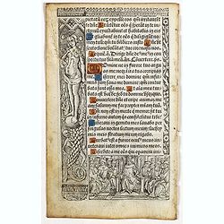
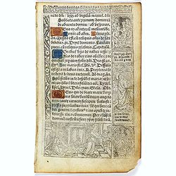
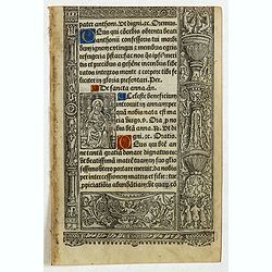
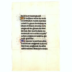
Leaf on vellum from a printed Book of Hours In Latin and French.
24 lines of printed text, surrounded by renaissance borders decorated with flowers, vases and figures. Gothic type, text in Latin, numerous one and two-line initials in g...
Date: Paris, Germain Hardouyn, c. 1520-1540
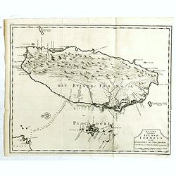
Kaart van het Eyland Formosa en de Eylanden van Piscadores.
The earliest printed map of Taiwan or Formosa. Oriented to the east, with north at the left, covering the entire island and the nearby Pescadores, now known as the Penghu...
Date: Amsterdam, 1724

United States of North America. Carte des Etats-Unis de l'Amerique Septentrionale / copiée et gravée sur celle d'Arrowsmith, corrigée et considérablement augmentée... par P. F. Tardieu...
FIRST EDITION. An impressive wall map here in 4 unjoined sheets and large margins. RARE in these untouched, full sheets. Recorded examples are usually offered as folding ...
Date: Paris: An XI - 1802
![Nouvelle-Hollande Nelle Galles du sud. Vue d'une partie de la ville de Sydney capitale des Colonies Anglaises aux Terres Australes . . . [plate XXXVII]](/uploads/cache/46359-250x250.jpg)
Nouvelle-Hollande Nelle Galles du sud. Vue d'une partie de la ville de Sydney capitale des Colonies Anglaises aux Terres Australes . . . [plate XXXVII]
An important view of Sydney Cove from Dawes Point looking eastward from Voyage de découvertes aux terres Australes by François Péron, 1824. This is one of the earliest de...
Date: Paris, 1824

Nieuwe kaart van Kanada . . .
Nice map of the Bay of Hudson, In Labrador, a small inset of Nova Scotia. The map is dated 1769. All text is in Dutch. The map shows the region shortly after the conclusi...
Date: Amsterdam, 1769
![[Navel battle between Portuguese and French Battle off Buttugar (Brazil).]](/uploads/cache/48526-250x250.jpg)
[Navel battle between Portuguese and French Battle off Buttugar (Brazil).]
Navel battle between Portuguese and French in the seas off the Poti guaran Territories in Brazil.Read more about "Les Grand Voyages" by Theodore De Bry [+]
Date: Frankfurt, 1594

Polus Arcticus cum vicinis regionibus.
1608 MERCATOR, G. / HONDIUS, J. - Rare map of the North Pole, shown as a rocky island surrounded by 'in-drawing seas' between four huge islands
Date: Amsterdam, 1608
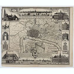
Marchionatus Sacri Romani Imperii.
Plan of the city of Antwerp in Belgium, by Claes Janszoon Visscher and first published by his son. The map is surrounded by 3 city views and 10 building vignettes and inc...
Date: Amsterdam 1624

Magnae Prussiae Ducatus Tabula denuo correcta et in lucem edita per Nicolaum Visscher.
Striking old color example of Visscher's map of Prussia and part of the Baltic region. Includes a gorgeous cartouche and banner key held aloft by 2 cherubs, plus 4 sailin...
Date: Amsterdam, 1690

Die Republic Holland oder die Verenigte Niederlande..
Charming map of the Netherlands, with inset maps of Novi Belgium area in America and Indonesia. With a fine cartouche.
Date: Leipzig, 1749
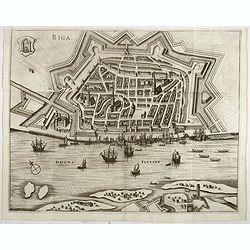
Riga.
Decorative view of Riga. This well executed engraving was published in 1729 and 1727 by Pieter van der AA, in Leiden in "Les Voyages tres-curieux et tres-renommez fa...
Date: Leiden, 1719
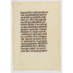
Leaf on vellum from a printed Book of Hours.
21 lines of printed text, surrounded by renaissance borders decorated with flowers, vases and religious scenes.From the press of the leading Parisian publisher and illumi...
Date: Paris, Germain Hardouyn, c.1520-1540
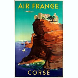
Air France - Corse.
Corsica poster for Air France, by Raoul Éric Castel (1915 - 1997) and published by Havas. Signed has work with Éric, he was born in Lyon and made many fine travel posters...
Date: Imprimerie Perceval Paris, ca. 1940-1950
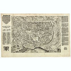
Jerusalem die vernaamste van alle steden... / Jerusalem die Heijlighe Stadt van God. . .
Very rare separately published plan of Jerusalem, engraved by Joannes van Doetecum Jr., Variant to Poortman, Kaarten in Bijbels, map 64. In the lower part, the copper pla...
Date: Amsterdam, 1598-1630

Région arctique.
1877 VIVIEN DE SAINT MARTIN, L. - Map of the North Pole, together with the often missing overlay with the Arctic expedition of Captain Nares.
Date: Paris, Hachette, 1877
![[Goose game board] Le 1914 Edition pochette.](/uploads/cache/47214-250x250.jpg)
[Goose game board] Le 1914 Edition pochette.
Goose game in the form of a folding map of north of France and Belgium, with part of England, Germany, Holland and Luxembourg.More about board games [+]
Date: Paris, 1914
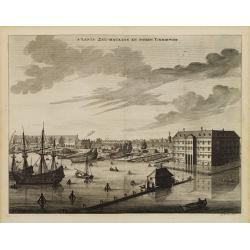
s'Lants Zee-Magazyn en Scheeps Timmer-werf.
Decorative view of the back yard formerly the V.O.C. warehouse and arsenal for the Admiralty of Amsterdam, now-a-days the Scheepvaartmuseum (Maritime Museum).The print is...
Date: Amsterdam, 1694
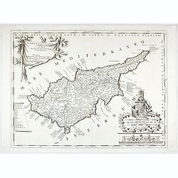
Acamantis insula hogidi Cipro . . .
Decorative map of Cyprus. The remarkable Vincenzo Coronelli (1650-1718), was a Franciscan Friar and appointed General of the Order in 1701. He was cosmographer to the Rep...
Date: Venice, 1700
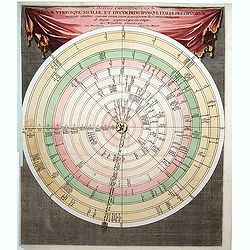
Discus Chronologicus Regum utriusque Siciliae et Ducum Princ
Chronological volvelle table showing the Sicilian rulers from the year 0 until 1730. COMPLETE with its volvelle. Each circle corresponds to a jurisdiction.
Date: Nuremberg, 1750

Carte de la province de Quan-tong, ou Lyau-tong et du Royaume de Kau-li. . .
Map of Korea. The map is of interest for the use of East Sea, the sea between Korea and Japan, here called "Mer de Corée" and "Meer von Korea".From an...
Date: Paris, 1757
Selling price: ????
Please login to see price!
Sold in 2023
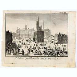
Il Palazzo pubblico della Citta di Amsterdam.
Fine panoramic views of the Dam square in Amsterdam, taken from Storia moderna di tutti I popoli del mondo , edited by Thomas Salmon. A Italian edition of this famous wor...
Date: Venice, 1740-1756
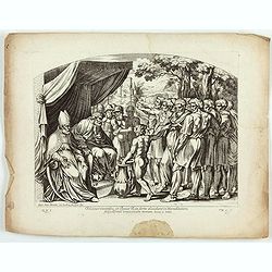
Eleazar sacerdos, et Iosue Rex sorte dividunt in Haereditatem Filiis Israel universam Terram ( Plate 49)
Fine etching by Nicolas Chapron, after Raphaël's (Raffaello Sanzio) frescoes in the Vatican Loggia. Scene illustrating Eleazar and Joshua to divide Canaan among the tribe...
Date: Paris, Petrus Mariette, 1649
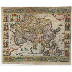
Asia recens summa cura delineata.
This is the rare early issue with decorative paneled borders of four sides. It is surrounded by elaborate borders incorporating twelve bird's eye views of cities and ten...
Date: Amsterdam, H.Hondius,1623
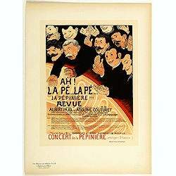
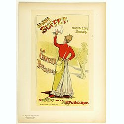
Ah la pé... La pé... La Pépinière Revue . . .
Chromo lithographed poster of Les Maîtres de l'Affiche being plate n°119. The "Les Maîtres de l'Affiche" contained 256 small for lithographic prints of the best...
Date: Paris, Imprimerie Chaix, 1898
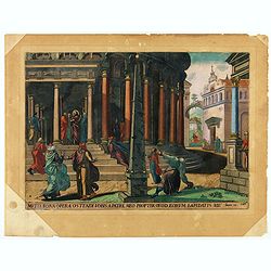
Multa bona opera ostendi vobis ex Patre meo : propter quod eorum lapidatis me. Joan 10.
A superb example of this illustration from Memorabilium Novi Testamenti in templo gestorum (Events in and around the Temple) (Events in and around the Temple). Christ in ...
Date: Antwerp, 1585
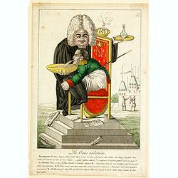
La Crise salutaire.
In this` fine French caricature we see Napoleon seated in side profile to the left on an ornate chair-commode, clasping his knees, benign forward to vomit into a bowl hel...
Date: Paris, 1814

Portrait de Benjamin Franklin.
Portrait de Benjamin Franklin. From Giulio Ferrario's work Le Costume ancien et moderne ou histoire du gouvernement, de la milice, de la religion, des arts, etc. publishe...
Date: Milan, 1827
![Terre de Diemen. Ourlaga. [plate IX]](/uploads/cache/46272-250x250.jpg)
Terre de Diemen. Ourlaga. [plate IX]
A portrait of the female Tasmanian Aboriginal Ourlaga, after the original sketches by Lesueur, from Voyage de découvertes aux terres Australes by François Péron, 1824.The...
Date: Paris, 1824
Selling price: ????
Please login to see price!
Sold in 2024
![[Australia, New Zealand and Oceania map with Ottoman script]](/uploads/cache/44319-250x250.jpg)
[Australia, New Zealand and Oceania map with Ottoman script]
Postcard size map in Ottoman script showing Australia, New Zealand and Oceania prepared by Mehmet EŞREF in a small atlas : عمومولاياةىشهانيىحاوىكوچكاطلاس [Umum-i vilayat...
Date: Istanbul, 1325 or 1909
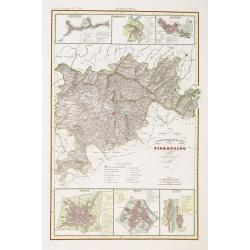
Compartimento Fiorentino. (Florence)
Very finely engraved and detailed map of the province of Firenze (Florence) Upper and lower part of the map, three inset plans of Namminiato, Modigliani and Volterra, Pis...
Date: Rome, 1860

Carte des Isles du Japon Sequels est remarque la Route..
This uncommon map of Japan, a reduced version of his larger map, contains comments about the nature of the country. For instance, Ocsaqui (Okazaki, near Nagoya) is said t...
Date: Paris / Amsterdam, 1679
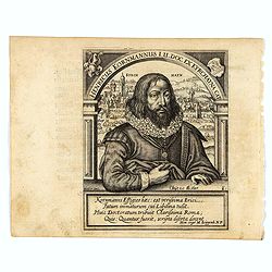
Henricus Kornmannus I.U. Doc. ex Kyrchayna cat.
Very skillfully engraved half-length portrait of Heinrich Kornmann, in frontal view, underneath an arch and with a view of Kirchhain in background and coats-of-arms in up...
Date: Frankfurt, 1630
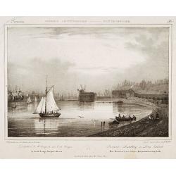
Pierpont's distillery on Long Island.
Milbert's topographical prints are an eyewitness record of life in America in the early 19th centuryDecorative print after Jacques Milbert, and lithographed by Sabatier a...
Date: Paris, 1829
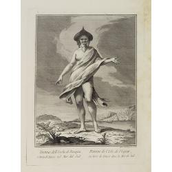
Donna dell' Isola di Pasqua, o terra di Davis nel Mar del Sud. / Femme de l' Isle de Pâques ou terre de Davis dans la Mer du Sud.
Full portrait of a woman, a native of Easter Island, a Chilean territory, is a remote volcanic island in PolynesiaFrom "Raccolta di stampe." a series of histori...
Date: Venice, Antonio Zatta, c.1790
Eugenie Buffet ... La chanteuse populaire.
Chromo lithographed poster of Les Maîtres de l'Affiche being plate n°151. The "Les Maîtres de l'Affiche" contained 256 small for lithographic prints of the best...
Date: Paris, Imprimerie Chaix, 1899
![[Title page] Le Nouveau Theatre du Monde.](/uploads/cache/47951-250x250.jpg)
[Title page] Le Nouveau Theatre du Monde.
The fine engraved frontispiece by F. Bleiswyk entitled "Le Nouveau Theatre du Monde" for Pieter van der AA. Shows Atlas carrying the world on his shoulders acco...
Date: Leiden, 1713

[Lot of 9 leaves with maps and views of Persia and Arabia).
Nineteen text leaves with wood block illustrations relating to Persia and Arabia, from the 1552 Latin text edition of Münster's Cosmographia, which is a short and complet...
Date: Basel, 1552

Comitatus Flandria.
First published by the van Langrens c.1595, after his acquisition of the plate, Visscher heavily re-engraved the map, inserting panelled borders on three sides (the lower...
Date: Amsterdam, c. 1630
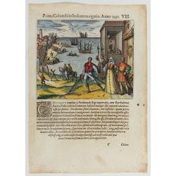
Prima Columbiin Indiam navigation Anno 1492.
Christopher Columbus and the Pinzon brothers leaving the port of Palos in Spain on August 3, 1492 for the New World. Right The King and Queen of Portugal Catholic Ferdina...
Date: Frankfurt, 1594

Carte particulière de la côte d'Afrique depuis le cap des Courans jusqu'à la baye de Ste Hélène. . .
Large and detailed sea chart of South Africa.Engraved by Guillaume-Nicolas Delahaye (1727-1802).Latitude and longitude scales, compass rose and system of rhumb lines, sou...
Date: Paris, 1745
![Cession de l'Isle d'Ohahiti au Capitaine Wallis par la Reine Obéréa. [Tome II Pl. 2.]](/uploads/cache/26111-250x250.jpg)
Cession de l'Isle d'Ohahiti au Capitaine Wallis par la Reine Obéréa. [Tome II Pl. 2.]
Queen Oberea's transfer ceremony to Captain Wallis on Tahiti.Engraved by François Godefroi. From the French edition of James Cook's first voyage entitled Relation des voy...
Date: Paris, 1774
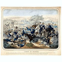
Combat de Palestro.
Showing the battle of Palestro lithographed by E.S. Walter and printed by De Becquet and published by Rousselot in Paris.The lithograph is part of a series of prints publ...
Date: Paris, ca. 1860
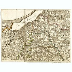
(Sheet X with Puk Bay from) General Tableau zur Karte von Alt Ost und West Preussen nebst dem aufgenommenen Trigonometrischen Netz. . .
Sheet IV with Zalew Wislany and the towns of Elblag, Paslek, Braniewo, etc, of this important multi-sheet map of Prussia, Lithuania, and Poland.The rare first edition of ...
Date: Berlin, 1802-1810
A printed leaf from a Book of Hours.
RECTO: Two 2-line and two 1-line initials in liquid gold on colored grounds. Miniature with Saint Anne. Decorative panel border in he right and lower margins.VERSO: One 2...
Date: Paris, G. Hardouin, 1512
![[Lot of 7 leaves] Curiensis civitas, Rhetorum…/Valesia/Solothurensis/Clarissimae civitatis/Genevensis/Basiliensis/Ursina…Bernensis/Sedunensis/Designatio …Badensis.](/uploads/cache/48278-250x250.jpg)
[Lot of 7 leaves] Curiensis civitas, Rhetorum…/Valesia/Solothurensis/Clarissimae civitatis/Genevensis/Basiliensis/Ursina…Bernensis/Sedunensis/Designatio …Badensis.
1552 MÜNSTER, S. - Seven text leaves illustrated with wood block bird's-eye views of Chur, Solothurn, Geneva, Basel, Bern, Sitten, Baden
Date: Basel, 1552

D' Admiralyteyts Huys - La maison de l'Amirauté.
Decorative print of the "D'Admiralyteits Huys", Het Prinsenhof, of the Dutch East India Company VOC. Located at the Oudezijds Voorburgwal 195-199, Amsterdam.
Date: Amsterdam, ca. 1700

Het Huisje door Czaar Peter den Grooten in den Jare 1697 te Zaandam bewoond.
Engraved by Cornelis van Baarsel (Utrecht 1761 - Amsterdam 1826-08-17) after a design of T. Monsieur M.Z. who made his drawing "after nature".A first state, the...
Date: Zaandam, 1823
![Flessingue Ville de l'Ile de Walcheren. [Vlissingen]](/uploads/cache/13105-250x250.jpg)
Flessingue Ville de l'Ile de Walcheren. [Vlissingen]
A very RARE panoramic view of the city of Vlissingen. The plate is numbered in red pencil in the upper right corner.Engraved by Jean Crepy (the father), who was active as...
Date: Paris, 1690-1720
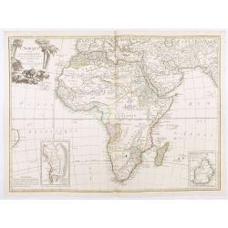
L'Afrique divisée en ses principaux Etats, assujettie aux observations astronomique.
Rare and attractive map of Africa, ornated with a decorative title cartouche showing luxuriant nature and a lion. With two inset maps : "Carte particulière du Cap d...
Date: Paris, Lattré, 1788
![[United States map with Ottoman script.]](/uploads/cache/44314-250x250.jpg)
[United States map with Ottoman script.]
Postcard-size map in Ottoman script showing the United States, prepared by Mehmet EŞREF in a small atlas: عمومولاياةىشهانيىحاوىكوچكاطلاس [Umum-i vilayat-ı Şahaneyi havi...
Date: Istanbul, 1325 or 1909
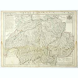
Carte de Suisse ou sont les Cantos de. . .
General map of Switzerland with all the cantons good detail, with the imprint "A Paris Chez l’Auteur sur le Quai de l’Horloge Avec Privilège Aout 1715". In the ...
Date: Paris, Aout 1715
![[Title page] Le Nouveau & Grand Illuminant Flambeau de la Mer. La troisième partie. …Par Nicolas Jans Vooght.](/uploads/cache/47950-250x250.jpg)
[Title page] Le Nouveau & Grand Illuminant Flambeau de la Mer. La troisième partie. …Par Nicolas Jans Vooght.
Allegoric frontispiece of the third edition of the "Zee-Fakkel" with French text. The "4" from the date 16"89" is in manuscript.
Date: Amsterdam, 1689
![Mortuary scene. Tahiti Islands ].](/uploads/cache/26380-250x250.jpg)
Mortuary scene. Tahiti Islands ].
This aquatint depicts a mortuary scene in front of a tapapow, a shed under which the dead bodies remains are exposed until they dry. Engraved by Roffi. Plate N° 83. From ...
Date: Milan, 1827
![[The Friendly Islands ].](/uploads/cache/26384-250x250.jpg)
[The Friendly Islands ].
Aquatint depicting seashore scene of the Friendly Islands. These islands are also known as the Friendly Islands because of the friendly reception accorded to Captain Cook...
Date: Milan, 1827
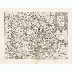
Brabantia.
Map of Brabant from Guicciardini's "Description de touts les Pais-Bais" edited by Plantin in 1582. The map drawn after Ortelius' map of Brabant, and after the l...
Date: Antwerp, 1582
![[Euroidenic Columns all parts of the light].](/uploads/cache/46171-250x250.jpg)
[Euroidenic Columns all parts of the light].
A detailed map from Учебный Географический Атлас published by the very successful St. Petersburg publisher "Cartographic institution A.Ilina" ("Картографич...
Date: St. Petersburg, 1899

Transom of a ship in gilded carved wood bearing the inscription "DUMONT- DURVILLE"
Decorative transom sign in gilded carved wood bearing the inscription "DUMONT- DURVILLE" in a foliage environment. The transom usually kept the name of the ship...
Date: France, ca. 1880
Manuscript leaf on vellum from a Dutch Book of Hours.
RECTO: Two 1-line capitals in red, blue or burnished gold with extensive penworkVERSO: One 1-line capitals in red, blue or burnished gold with extensive penwork.
Date: Flanders ca.1450
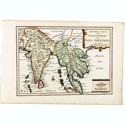
Les Vrays Indes dits Grands Indes ou Indes Orientales Par N. de Fer. Geographe de Sa Majeste Catoliques et de Monseigneur le Dauphin.
Detailed map on India, Thailand, the Malay Peninsular and the south coast of China up to Macao. The map was engraved by C. Inselin.
Date: Paris, 1705
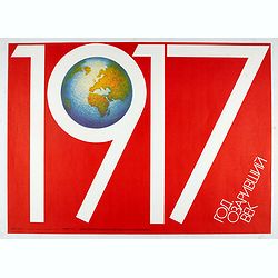
1917. Enlightened century
Uncommon Soviet propaganda poster published during the early years of the Perestroika & Glasnost period (1985 - 1991) by Plakat (All-Union...
Date: Moscow, 1987
Selling price: ????
Please login to see price!
Sold in 2024

Novissima Flandriae Comitatus tabula. . .
Rare issue of Theodorus Danckert's attractive map of eastern Belgium provinces, Flanders, with Brugge, Oostende, Gent, Mons, Antwerp, Cambray, etc..Decorative title carto...
Date: Amsterdam, 1700
Manuscript leaf on vellum written in a late gothic hand.
VERSO: One 2-line initial P in burnished gold on a red and blue ground and 2 line-fillers on a red and blue ground.RECTO: 17 Lines of text, intils filled in with yellow.
Date: France or Flanders, c.1500
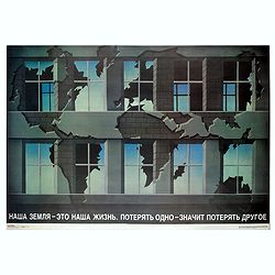
Our land is our life...
Uncommon Soviet propaganda poster. "Our land is our life. Lost one means lose other."Read more about the Soviet propaganda poster. [+]
Date: Moscow, 1989
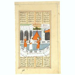
Persian miniature paintings, Mogul Dynasty.
Indo/Persian, Mogul Dynasty miniature painting in delicate Opaque watercolors on paper, with Islamic scripts on recto and verso. Miniature about 70 x 150mm. Painted in gi...
Date: Northern Indian Mogul dynasty, ca 1800-1850

Kaartje van Asia. . .
Attractive and rare map of Asia. From Atlas Portatif . With a curious and oversized Hokkaido. The map is of interest for the use of Corease Zee for the sea between Korea ...
Date: Deventer, 1742
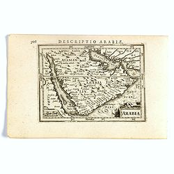
Arabia.
FIRST IMPRINT FROM THE NEWLY ENGRAVED PLATES IN 1616. - A rare miniature map of the Arabian Peninsular. Title cartouche on the lower left corner.First published in 1598 i...
Date: Amsterdam, J. Hondius, 1616
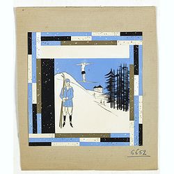
Art déco gouache.
Outstanding "art deco" gouache (unsigned) from the workshop of "Robert Pichon. Ateliers de Dessin et Lithographie – 10, rue Rochechouart – Paris. The goua...
Date: Paris, ca. 1930

A Hysterical Map Of Death Valley National Monument -- And It's Looking Mighty Low
First edition Humorous map of Death Valley. "Drawn In Broken English by Jolly Lindgren," this comic pictorial map is full of puns and comic vignettes related to...
Date: Spokane, Wash., Lindgren Brothers, 1948
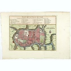
Plan de la ville de Siam.
Early plan of Siam, Thailand. Across the top is an extensive list of 22 important sites and locations keyed to the plan with tiny letters and numbers.Jacques Nicolaas Bel...
Date: Paris, 1750

Présentation solennelle d'une seringue d'honneur au 9e lancelot pour le Ier de l'an 1832.
Uncommon plate showing a solemn presentation of a syringe of honor at the 9th Lancelot for the 1st of the year 1832]. Hand colored lithographed plate by Delaporte after C...
Date: Paris, c. 1832
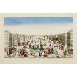
La Feste du Poids au Mogol qui se célebre chez ses Peuples avec grande vénération.
So-called optical print illustrating a perspective view of a square in Mongolia.Mondhare, active at rue St.Jacques a l'Hotel Saumur, was a well-known publisher of optical...
Date: Paris, 1760
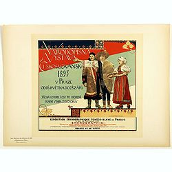
Rhodopsin Vistana Czechoslovakia 1895 . . .
Chromo lithographed poster of Les Maîtres de l'Affiche being plate n°56. The "Les Maîtres de l'Affiche" contained 256 small for lithographic prints of the best ...
Date: Paris, Imprimerie Chaix, 1897
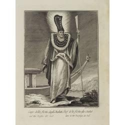
Capo della flotta degli Otahiti nel Mar Pacifico del Sud. / Chef de la flotte des Otahiti dans la Mer Pacifique du Sud.
Full portrait of the captain of the Otahiti flotilla, from Tahiti. A rare engraving from "Raccolata di stampe ... di varie nazioni". From the original drawing ...
Date: Venice, Antonio Zatta, c.1790
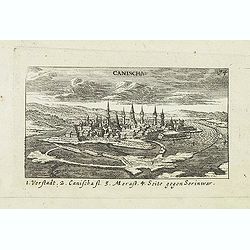
Canischa. (Nagykanizsa / Kanizsa)
Panoramic view of Nagykanizsa / Kanizsa. Published in "Der Donau-Strand Mit allen seinen Ein- und Zuflüssen. . .". Published by Jacob Sandrart.
Date: Nuremberg, Jacob Sandrart, 1684

Mappa Geographica provinciae Nova Ebboraci ab Anglis NEW-YORK dictae. . .
During the Revolution, this map afforded British commanders an excellent overview of areas that would be crucial in the early years of the war, particularly the Hudson Va...
Date: Nuremberg, 1778
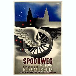
Spoorweg Museum Thans in Het Rijksmuseum.
Interesting Art Deco style poster for the Railway Museum, now in the Rijksmuseum. Carolus Adrianus Maria Thole (20 April 1914 – 26 March 2000) was a Dutch-Italian painter...
Date: Amsterdam, 1942
