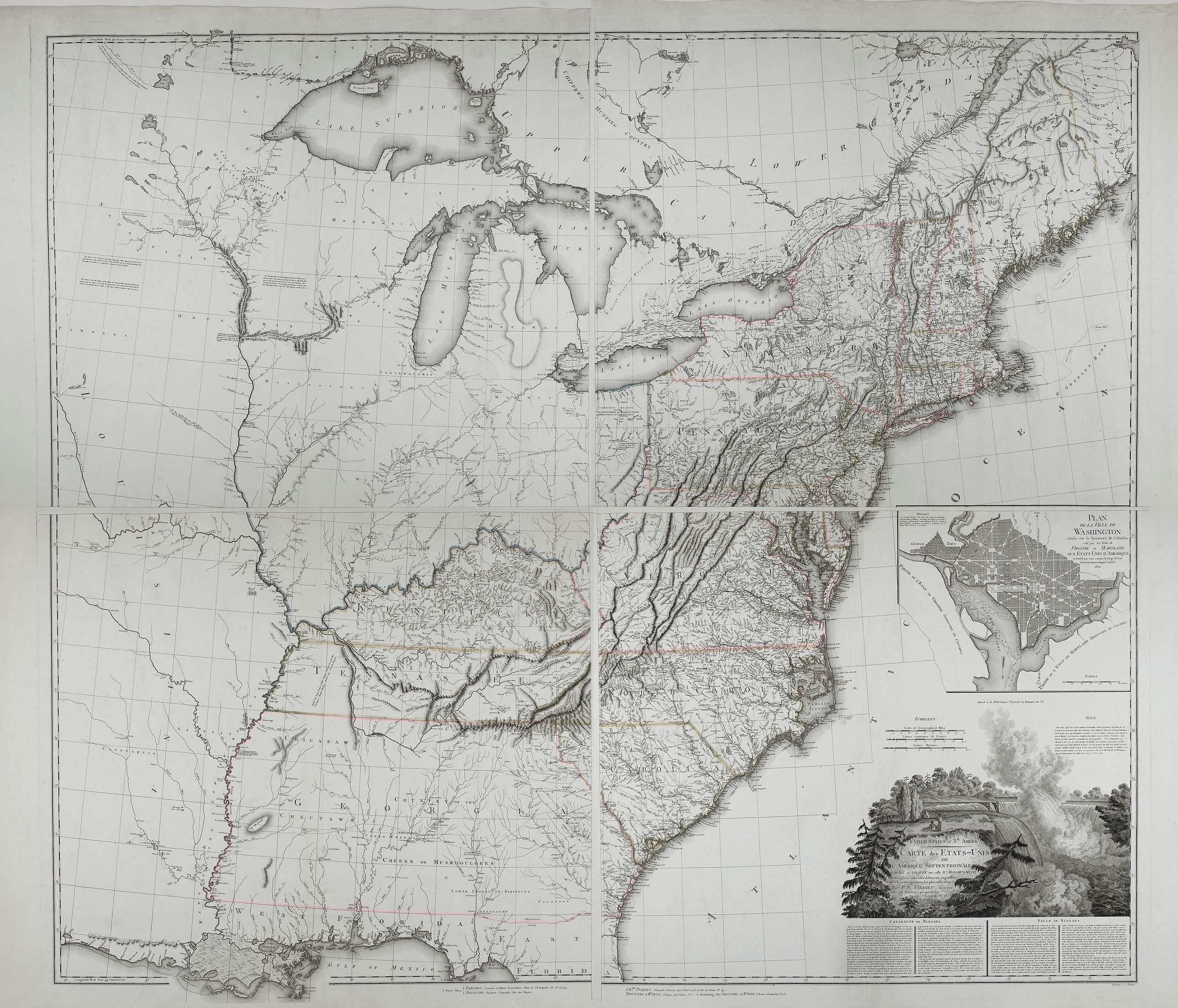
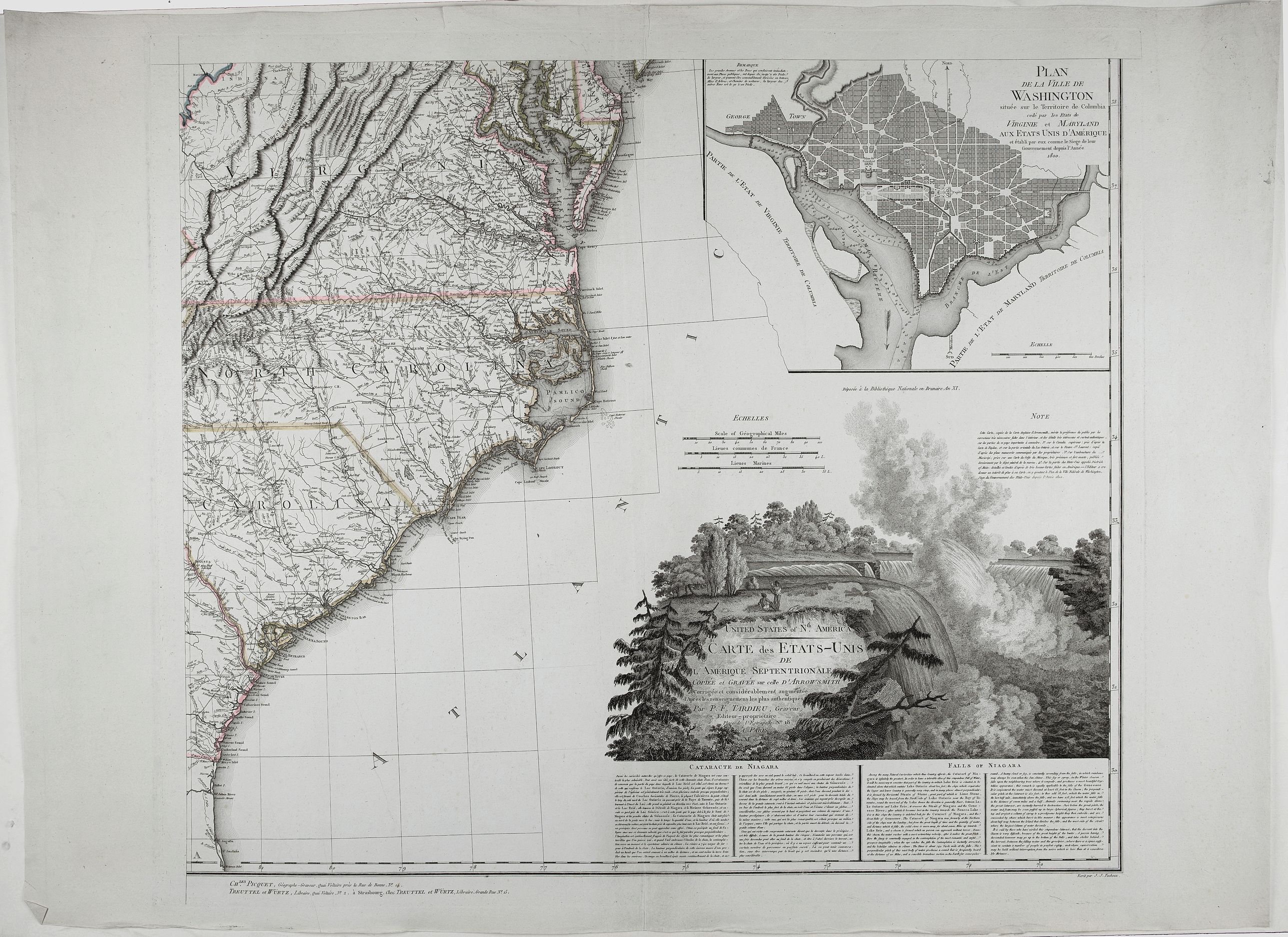
United States of North America. Carte des Etats-Unis de l'Amerique Septentrionale / copiée et gravée sur celle d'Arrowsmith, corrigée et considérablement augmentée... par P. F. Tardieu... |
||||||||||||||||||||
|
||||||||||||||||||||
|
|
||||||||||||||||||||
$8000 / ≈ €6998This item is available for immediate sale! Questions before Buying ?
We are happy to answer your questions.
8000.00
|
My Collection +
Add this or any of your favorite items in one place. If you want to save the items permanently, you have to sign in or create an account first. |
|||||||||||||||||||
Description
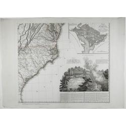
FIRST EDITION. An impressive wall map here in 4 unjoined sheets and large margins. RARE in these untouched, full sheets. Recorded examples are usually offered as folding case maps, including large vignettes of Niagara Falls and a plan of Washington, D.C.
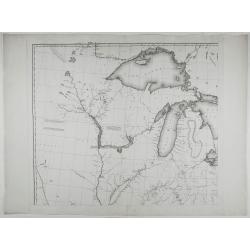
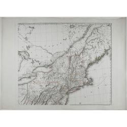
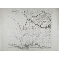
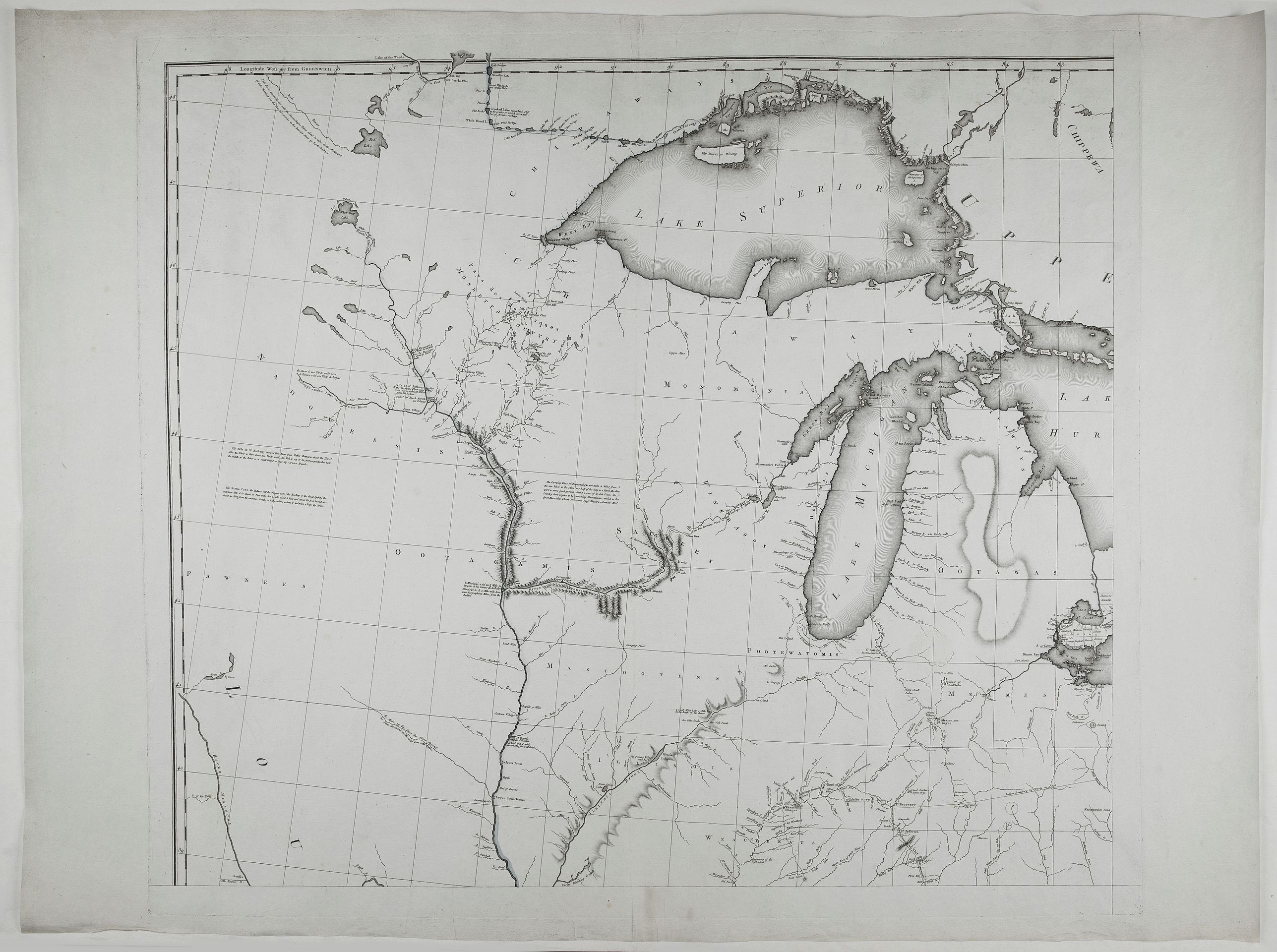
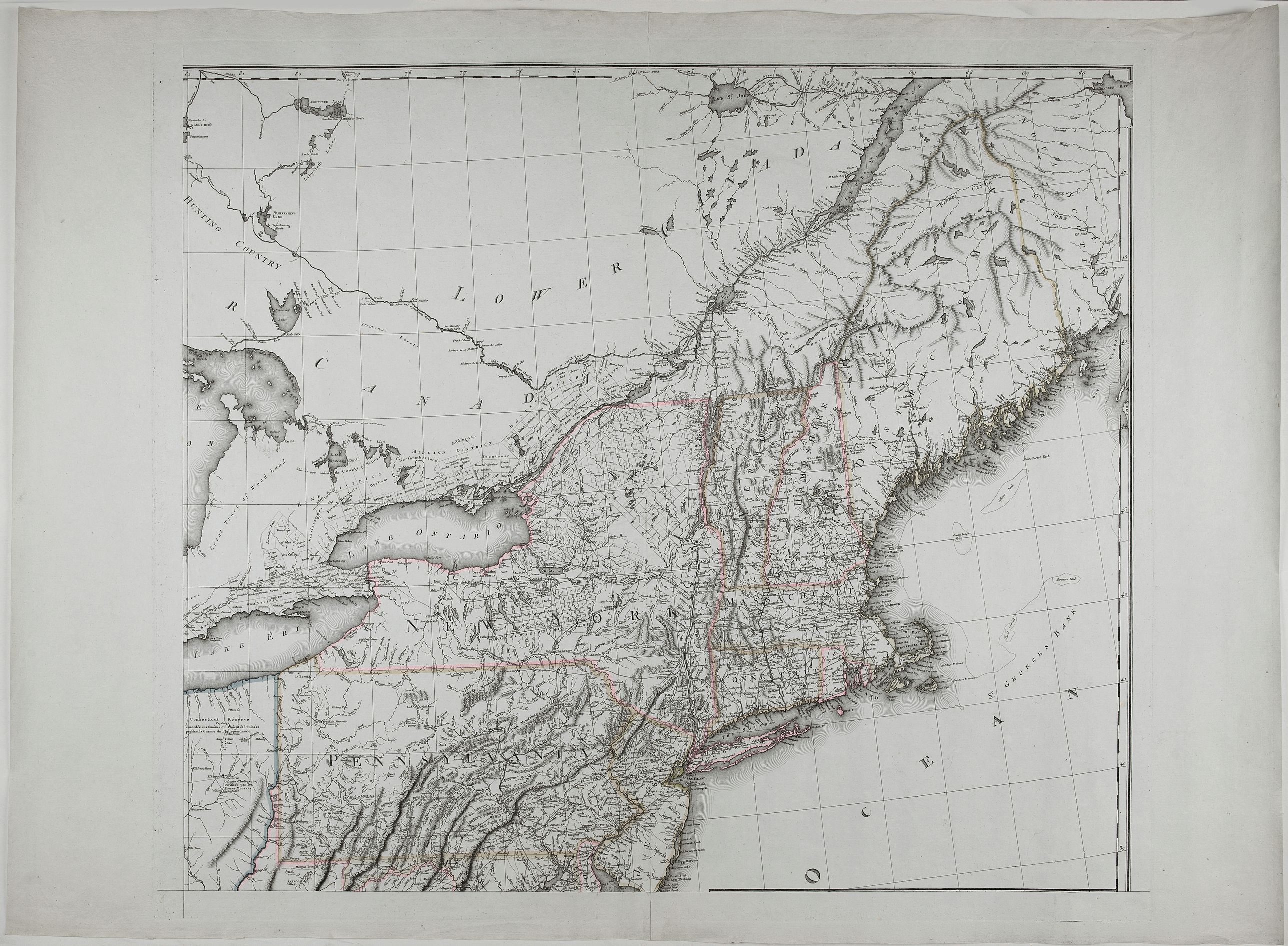
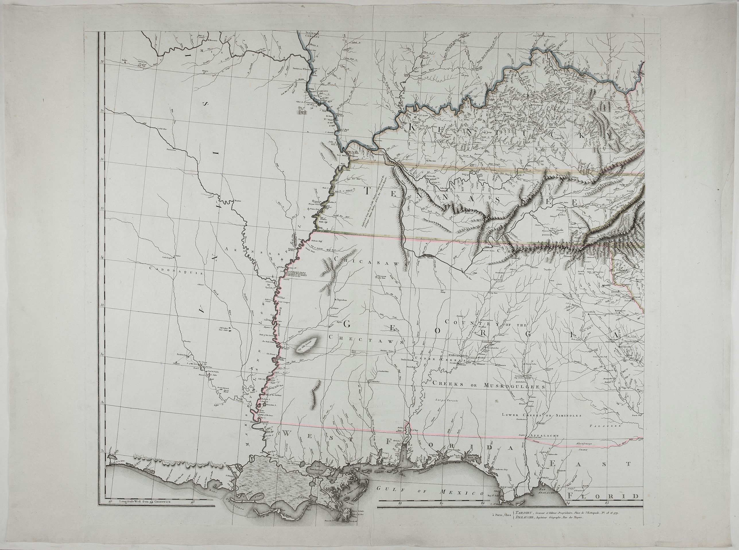
Tardieu's map is a direct copy of Arrowsmith's "Map of the United States" except for certain parts (mentioned by Tardieu in his "Note" above the title) that Tardieu has altered and improved based on other sources. The map shows the eastern seaboard and extends westward as far as where the Missouri River crosses 97o lat.
Showing the United States and Canada.
Using Arrowsmith's map as a template, Tardieu creates a new map that reflects this Paris engraver's finer engraving skills. Over the next 18 years, Tardieu's regularly updated and improved his map, often in advance of improvements by Arrowsmith, who also periodically updated his 4-sheet map for the next several decades.
Adorned with a cartouche highlighting Niagara Falls, a new American icon, it defines the nation’s boundaries and depicts the states of Vermont, Kentucky, and Tennessee.
An inset showcases Pierre L’Enfant’s plan for the nation’s capital in Washington, DC. The plan, inspired by Baroque city designs, features broad diagonal avenues imposed on a grid street system, reflecting the city’s proposal to function as a ceremonial seat of government.
Scale [ca. 1:1,860,000].
Primarily based on the work of Aaron Arrowsmith, who first published his monumental map of North America in 1796, the current map shows the United States at a time of great transition, just before the acquisition of the Louisiana Territory (1803) and before the extent of the western discoveries of Lewis and Clark during their exploring expedition of 1804, 1805, 1806, and those of Zebulon Pike of 1806 and 1807.
Remarkably fine engraving, as is characteristic of Tardieu's maps.
The map is known in 6 states:
State 1: 1802 (dated)
State 2: 1808 (adding Michigan Territory, Ohio, Vermont, Kentucky & Tennessee).
State 3: 1812 (dated) Mississippi Territory, Indiana Territory, West Florida is shown, Louisiana does not yet appear as a state and there is a massive area called Indiana below Lake Michigan, with an unnamed Territory to the west.
State 4: (circa 1816), adds the Illinois Territory and a massive Northwest Territory.
State 5: (circa 1818), Alabama Territory appears for the first time, the roads in Illinois Territory and Indiana Territory have been changed and East Florida and West Florida are no longer named. State 6: 1820. Adds a set of half-sheets at the bottom of the map, extending the map's coverage to include all of Florida.
Please note that the main illustration is a compilation. The four sheets are in their original unjoined state with large margins. Very rare in this condition.
Reference: Karrow I:1385; see Phillips Maps 876 & 873.
FAQ - Guarantee - Shipping
Buying in the BuyNow Gallery
This item is available for immediate purchase when a "Add to Cart" or "Inquire Now" button is shown.
Items are sold in the EU margin scheme
Payments are accepted in Euros or US Dollars.
Authenticity Guarantee
 We provide professional descriptions, condition report (based on 45 years experience in the map business)
Paulus Swaen warrants the authenticity of our items and a certificate of authenticity is provided for each acquired lot.
Condition and Coloring
We indicate the condition of each item and use our unnique HiBCoR grading system in which four key items determine a map's value: Historical Importance, Beauty, Condition/Coloring and Rarity.
Color Key
We offer many maps in their original black and white condition. We do not systematically color-up maps to make them more sellable to the general public or buyer.
Copper engraved or wood block maps are always hand colored. Maps were initially colored for aesthetic reasons and to improve readability. Nowadays, it is becoming a challenge to find maps in their original colors and are therefor more valuable.
We use the following color keys in our catalog:
Original colors; mean that the colors have been applied around the time the map was issued.
Original o/l colors; means the map has only the borders colored at the time of publication.
Colored; If the colors are applied recently or at the end of the 20th century.
Read more about coloring of maps [+]
Shipping fee
A flat shipping fee of $ 30 is added to each shipment by DHL within Europe and North America. This covers : International Priority shipping, Packing and Insurance (up to the invoice amount).
Shipments to Asia are $ 40 and rest of the world $50
We charge only one shipping fee when you have been successful on multiple items or when you want to combine gallery and auction purchases.
Read more about invoicing and shipping
FAQ
Please have a look for more information about buying in the BuyNow gallery
Many answers are likely to find in the general help section.
My Collection+
![]()
With My Collection+ you can collect all your favorite items in one place. It is free, and anyone can create his or her virtual collection.
Unless you are logged in, the item is only saved for this session. You have to be registed and logged-in if you want to save this item permanently to My Collection+.
Read More[+]
Register here, it is free and you do not need a credit card.
Add this item to
My Collection+
or click the following link to see My Collection+.
| Digital Image Download | |
|
Paulus Swaen maintains an archive of most of our high-resolution rare maps, prints, posters and medieval manuscript scans. We make them freely available for download and study. Read more about free image download |
Click the image for a free small image download. |
In accordance with the EU Consumer Rights Directive and habitually reside in the European Union you have the right to cancel the contract for the purchase of a lot, without giving any reason.
The cancellation period will expire 14 calendar days from the day after the date on which you or a third party (other than the carrier and indicated by you) acquires, physical possession of the lot. To exercise the right to cancel you must inform Paulus Swaen Inc, of your decision to cancel this contract by a clear statement (e.g. a letter sent by post, or e-mail.
To meet the cancellation deadline, it is sufficient for you to send your communication concerning your exercise of the right to cancel before the cancellation period has expired.
Recently Viewed

United States of North America. Carte des Etats-Unis de l'Amerique Septentrionale / copiée et gravée sur celle d'Arrowsmith, corrigée et considérablement augmentée... par P. F. Tardieu...
FIRST EDITION. An impressive wall map here in 4 unjoined sheets and large margins. RARE in these untouched, full sheets. Recorded examples are usually offered as folding ...
Date: Paris: An XI - 1802
