Popular Listings
![[Title page from ] Le Theatre du Monde ou le nouvel atlas mis en lumière par Guillaume et Jean Blaeu. La seconde partie de la seconde.](/uploads/cache/47923-250x250.jpg)
[Title page from ] Le Theatre du Monde ou le nouvel atlas mis en lumière par Guillaume et Jean Blaeu. La seconde partie de la seconde.
Frontispiece of the second part of the second part of this fine atlas. At top, a coat of arms surmounted by a crown and surrounded by two golden chains, the bigger carryi...
Date: Amsterdam, 1644

Cary's New Terrestrial Globe Exhibiting The Tracks and Discoveries made by Captain Cook; Als...
An early Regency 21-inch terrestrial globe CARY, John and William. - Cary's New Terrestrial Globe Exhibiting The Tracks and Discoveries made by Captain Cook; Also those o...
Date: London, 1815/1818
![[Portraits. Friendly Islands ].](/uploads/cache/26385-250x250.jpg)
[Portraits. Friendly Islands ].
Aquatint depicting inhabitants of the Friendly Islands. Plate N°79. From Giulio Ferrario's work Le Costume Ancien et Moderne ou Histoire du gouvernement, de la milice, de...
Date: Milan, 1827
![[No title] Gouache of a class scene with globe, revolting students and a teacher.](/uploads/cache/44404-250x250.jpg)
[No title] Gouache of a class scene with globe, revolting students and a teacher.
Gouache of a class scene with a globe centered on Europe and Africa with revolting students and a teacher. Original design for a pulp publication.
Date: ca. 1950-1960
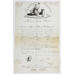
Passeport.
Passport for the United States in the name of Madeleine Lavit Femme Lory, issued by the Commission of Interior Relations and approved by the Committee of Public Safety.Th...
Date: Paris, 1795
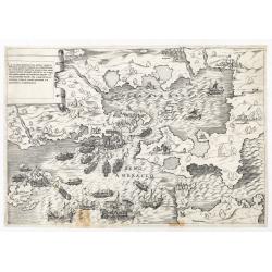
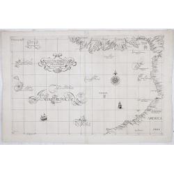
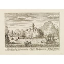
La dimostratione del luogo dove al presente sitrova l'armat di Barbarossa, et de Christiani detto il golfo dell 'Artha anti ch amente il sino ambracio…
The title cartouche at the top left reads: "La Dimostratione Del Luogo Dove Al Presente Sitrova L'Armat Di Barbarossa, et De Christiani Detto Il Golfo Dell' Artha An...
Date: Rome, c. 1540
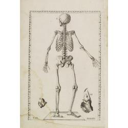
Anatomical print. TAB. XXXXIV.
Decorative and rare full-page anatomical copperplate engraving by Giulio de' Musi after a drawing by Eustachius and Pier Matteo Pini. From Tabulae anatomicae. In 1552 wit...
Date: Rome, Francesco Gonzaga, 1714

The Greyhound Map of This Amazing America. . .
A large colored lithograph map of the USA, published by the Greyhound Corporation during the Second World War. The map demonstrates where all the Greyhound bus routes int...
Date: United States, 1941
Malabar.
Small map illustrating the south western seacoast of India. Oriented with East on top, surrounded by text in Dutch.Nicolaes de Clerck (de Klerc) was active as engraver an...
Date: Amsterdam, Cloppenburch, 1621
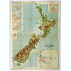
Bartholomew's Touring Map of New Zealand.
A full color map. 'Reduced Survey Map of New Zealand, colored to Show Height of Land'. With insets of Auckland Harbour, Wellington and Port, Christchurch and Port Lyttelt...
Date: Edinburgh, 1935

Flandria.
Very decorative, egg-shaped map. This is the last and very rare third state with the signature Theodorus Galle. The fortifications along the Scheldt River are added and t...
Date: Antwerp, after 1612
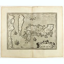
IAPONIAE INSULAE DESCRIPTIO.Ludoico Teisera auctore.
The map was based upon the manuscript draft supplied to Ortelius in about 1592 by the famous official Portuguese chart maker, Luis Teixeira , who was the cartographer to...
Date: Antwerp, 1598
(Portrait of Joseph-Marie Jacquard).
A rare woven silk portrait of Joseph-Marie Jacquard after Bonnefonds, completed on the Jacquard punched-card loom. Woven by Carquillat in the silk factory of Didier Petit...
Date: France, ca. 1840

Mappa geographica Provinciæ Nova Eboraci ab Anglis New-York . . .
Lower part of the two sheets map of Homann Heirs' edition of Sauthier's celebrated map of New York and New Jersey, made during the Revolutionary War. Appears in Homann's ...
Date: Nuremburg, 1778

Missions et Résidences dans la Partie Septentrionale de l'Amérique Contenant 50 Jésuites.
Very rare missionary map of North America from "Atlas Universel indiquant les établissemens des Jésuites: avec la manière dont ils divisent la terre, suivi desévénem...
Date: Paris, Ambroise Dupont , 1826
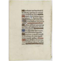
Manuscript leaf on vellum from a Dutch Book of Hours.
VERSO: One 1-line capitals in red, blue or burnished gold with extensive penwork.
Date: Flanders ca.1450
IV Compartimento Aretoni. . .
Very finely engraved and detailed map centered on Arezzo and Lago Trasimeno. Lower part three inset plans of Cortona, Arezzo and Chiusi. In upper corners plans of Montepu...
Date: Rome, 1860

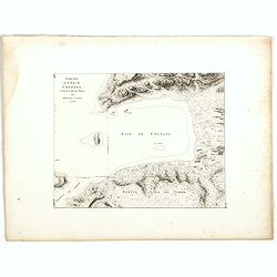
De Zuydwest-Kust van Het Eyland Ceylon.
A finely engraved and detailed chart of Nilwella / Kudawella Harbor.Very rare: only included in the 6th volume (so-called secret atlas) of Van Keulen's. A lettered key in...
Date: Amsterdam, 1753
Leaf on vellum from a manuscript Book of Hours.
RECTO: One 2-lines initial decorated with flower in liquid gold on colored grounds and six 1-line initials in liquid gold on colored grounds and five line-fillers in same...
Date: France, c. 1520
![[ Original Chinese advertising poster for ] [Google translate: Vendor Yiwei Shikou Supervisor Store Baishun Chengyan]](/uploads/cache/45082-250x250.jpg)
[ Original Chinese advertising poster for ] [Google translate: Vendor Yiwei Shikou Supervisor Store Baishun Chengyan]
This poster, an advertisement from the 1930s, melds the meticulous detail of traditional Chinese painting with the craft of color lithography. It depicts a beautiful woma...
Date: Shanghai, 1950/1960
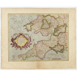
Cornubia, Devonia, Somersetus, . . .
A very nice map showing the south-western part of England. Mercator was born in Rupelmonde in Flanders and studied in Louvain under Gemma Frisius, Dutch writer, astronome...
Date: Amsterdam, 1630
Selling price: ????
Please login to see price!
Sold in 2025
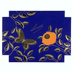
Loriot.
Lithographed poster for Loriot, a chocolate and confiserie French brand. A striking example of commercial artworks produced by the artist and graphic designer Robert Pich...
Date: Paris, between 1925 and 1930
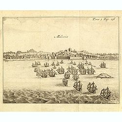
Malacca.
Fine print showing Dutch vessels offshore the city of Malacca, between Singapore to its south and Kuala Lumpur, the capital of Malaysia to its north.From the French reiss...
Date: Amsterdam, J.F. Bernard, 1725
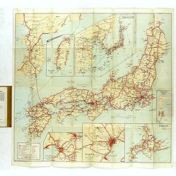
Travellers' Map of Japan, Chosen (Korea), Taiwan (Formosa) with Brief Descriptions of the Principal Tourist Points of Japan.
An early 20th century map which wss published in Tokyo for English speaking tourists.Very detailed set of maps of Japan and parts of Korea, Taiwan and part of China, show...
Date: Tokyo, 1925
![[Two plates on one sheet] Ordinanza Turchesa alla presa di Zigeth in Ongaria l’anno 1566 / Ordinanza Turchesca sotto Viena, contra lo Invictißimo Imperatore Carlo quinto l'anno 1550.](/uploads/cache/49073-250x250.jpg)
[Two plates on one sheet] Ordinanza Turchesa alla presa di Zigeth in Ongaria l’anno 1566 / Ordinanza Turchesca sotto Viena, contra lo Invictißimo Imperatore Carlo quinto l'anno 1550.
Ordinanza Turchesca sotto Viena, contra lo Invictißimo Imperatore Carlo quinto l'anno 1550". C. 1560. This extremely rare plate depicts the order of battle and forma...
Date: Venice, 1550/ 1566
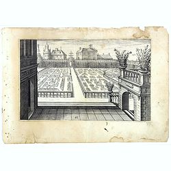
Perspective print by Vredeman de Vries. 43.
Engraving from Perspective, c'est a dire, le tresrenomme art du poinct oculaire d'une veue dedans ou travers regardante, estant sur une muraille unie, sur un tableau, ou ...
Date: The Hague, 1604 - 1605
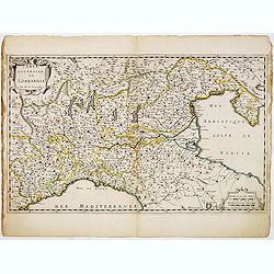
Carte Générale de Lombardie.
Fine map of Northern and middle part of Italy, engraved by A Peyrouin. According to the credit in the cartouche the map has been prepared by Pierre Duval.
Date: Paris, ca. 1650
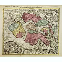
Zeelandiae Comitatus. . .
Scarce map of Zeeland, this is the state published by Tobias Conrad Lotter, previously published by Matthäus Seutter.Impressive cartouche with coat of arms of Zeeland top...
Date: Augsburg, c.1760
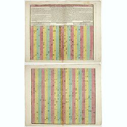
![Etats-Unis de L'Amerique Septentrionale. [Two sheets in manuscript ]](/uploads/cache/03972-250x250.jpg)
Etats-Unis de L'Amerique Septentrionale. [Two sheets in manuscript ]
Two sheets giving detailed information in French about the population in 1810, principal cities, products of industry and commerce, the financial situation for 1818, etc....
Date: France, ca. 1819
![Village fortifié bâti sur un Rocher troué de la Nouvelle Zélande. [Tome III Pl. 10.]](/uploads/cache/26110-250x250.jpg)
Village fortifié bâti sur un Rocher troué de la Nouvelle Zélande. [Tome III Pl. 10.]
A view of a village fortified on a hollow rock in New Zealand. Engraved by François Godefroi. From the French edition of James Cook's first voyage entitled Relation des v...
Date: Paris, 1774

An elegant woman seducing a man.
Lovely art deco pochoir by Russo-Italo artist Endré (Andrew de Passano) 1905-93. Exotic and gorgeously colored Art Deco print with elaborately robed people. The colors a...
Date: Paris, ca. 1930
![Naumaohiae [sic] id est navalis pugnae ex vetusteis lapidum et nummorum monumenteis graphica deformatio.](/uploads/cache/49142-250x250.jpg)
Naumaohiae [sic] id est navalis pugnae ex vetusteis lapidum et nummorum monumenteis graphica deformatio.
Naval engagement set inside an arena, spectators in the stands attending the event; reclining river god and nymphs in the lower part. From "Speculum Romanae Magnific...
Date: Rome, ca. 1575
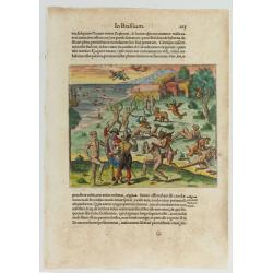
Cacodemon attacking the savages.
Cacodemon ("evil spirit") attacking the savages. Read more about "Les Grand Voyages" by Theodore De Bry [+]
Date: Frankfurt, 1594
![[Title page] Atlas Tot Amsterdam Bij Iustus Danckers in de Calverstraet inde Damcbaerhrijt.](/uploads/cache/47920-250x250.jpg)
[Title page] Atlas Tot Amsterdam Bij Iustus Danckers in de Calverstraet inde Damcbaerhrijt.
Decorative title page with the figure of Atlas, standing on a globe of the Old World. The left and bottom right corners have animals and people from different parts of th...
Date: Amsterdam, ca. 1680
Selling price: ????
Please login to see price!
Sold in 2024
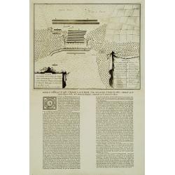
Plan De l'Action.. Auprès de Wynendale le 28 Sept. 1708.
A rare broadside sheet represents a conventional battle plan near the town of Torhout with the Castle Wynendale. The plan depicts the situation of 28 September 1708. Incl...
Date: Bruxelles, c.1708
![[Title page] Atlas Minor Praecipua Orbis Terrarum Imperia, Regna et Provincias , Germaniae Potissimum. . .](/uploads/cache/48479-250x250.jpg)
[Title page] Atlas Minor Praecipua Orbis Terrarum Imperia, Regna et Provincias , Germaniae Potissimum. . .
An attractive and highly decorative title page to Seutter's Atlas Minor. Engraved by Martin Crophius after Jacob Weyerman. The engraving is packed with lively figures fro...
Date: Augsburg, 1744
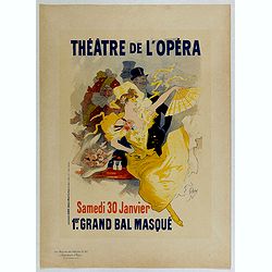
Théâtre de l'Opéra.
Chromo lithographed poster, "Théâtre de l'Opéra.", by CHERET, Jules. Plate 57, published in Maître 15, on February 1897. The "Les Maitres de l'Affiche"...
Date: Paris, Imprimerie Chaix, February 1897

Anamorphose.
Perspective anamorphosis is an ingenious perspective technique that gives a distorted image of the subject represented in a picture when seen from the usual viewpoint but...
Date: France, ca. 1900
Anamorphose.
Perspective anamorphosis are an ingenious perspective technique that gives a distorted image of the subject represented in a picture when seen from the usual viewpoint bu...
Date: Paris, ca. 1900
Het Groote Tafereel der Dwaasheid.
AN EARLY ISSUE of this biting and vulgar satire on the Mississippi and South Sea Bubbles and an extraordinary visual record with 78 plates of the first banking crash, sho...
Date: Amsterdam, 1720
![[Pirogues in the bay of the voyage of the Resolution. The Marquesas Islands ].](/uploads/cache/26373-250x250.jpg)
[Pirogues in the bay of the voyage of the Resolution. The Marquesas Islands ].
Aquatint depicting men in pirogues in the Bay of the Resolution from the Marquesas Islands engraved by Biasioli. Plate N° 91. From Giulio Ferrario's work Le Costume Ancie...
Date: Milan, 1827
Carte de la province de Quan-tong, ou Lyau-tong et du Royaume de Kau-li ou Corée. . . / Kaart van t' Landschap Quan-Tong . . .
Uncommon issue of this fine map of Korea. The map is of interest for the use of East Sea, the sea between Korea and Japan, here called "Mer de Corée.Decorative title...
Date: Paris, 1749-1773
Carte de la Floride, de la Louisiane, et Pays Voisins. . .
Jacques Nicolaas Bellin (1703-1772) was one of the most important and proficient French cartographers of the mid-eighteenth century. He was appointed the first Ingenieur ...
Date: Paris, 1757
Carta particolare del'mare del Zur che comincia con il capo S. Francesco nel Peru e finisce con il capo S. Lazaro nella nuova Spagnia.
FIRST EDITION Dudley’s magnificent chart of the Pacific Coast of Central and South America, from the coast of Columbia and Ecuador in the north to the Bay of Honduras in ...
Date: Florence 1661
Selling price: ????
Please login to see price!
Sold in 2023
![[Improve the work of all lines of the transport Conveyor.]](/uploads/cache/47058-250x250.jpg)
[Improve the work of all lines of the transport Conveyor.]
Uncommon Soviet propaganda poster from Kommunar Publishing, located south of Moscow in Tula at 150 Friedrich Engels Street. The publishing house also issued the Kommunar ...
Date: Moscow, 1984
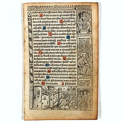
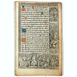
Leaf on vellum from a printed Book of Hours.
24 lines of printed text, surrounded by renaissance borders decorated with scenes and figures.The firm of Thielman Kerver is best known for its lovely printed Books of Ho...
Date: Paris, Philippe Pigouchet for Simon Vostre, ca. 1502
![Terre de Diemen. Arra-Maida. [plate XII]](/uploads/cache/46275-250x250.jpg)
Terre de Diemen. Arra-Maida. [plate XII]
A portrait of a female Tasmanian Aboriginal Arra-Maida, after the original sketches by Lesueur, from Voyage de découvertes aux terres Australes by François Péron, 1824.Th...
Date: Paris, 1824
Selling price: ????
Please login to see price!
Sold in 2024
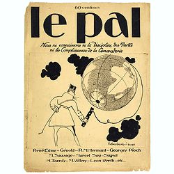
Le Pal - Nous ne connaissons ni la discipline des partis ni les complaisances de la camaraderie.
Original cover design in pen and ink by Henri Desbarbieux for the satirical bi-monthly journal Le Pal.Not much information is found about Henri Desbarbieux. In this BNF l...
Date: Paris, 1925

Nieuwe Kaart van de Grootbrittannische Volkplantingen in Noord America waar in Tevens de Fransche Bezittingen en de Landen tuschen die Beide Volken. . .
A map of the east-coast of America from New Foundland till Florida, divided in French and British properties. Reduced size Dutch edition of Mitchell's map of North Americ...
Date: Amsterdam, 1769
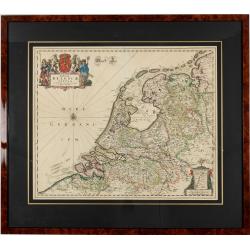
Foederatae Belgicae Tabulae.
Fine, detailed map of the area of the modern Netherlands, less the southern part of Limburg, of which the small area around the town of Maastricht is shown in the inset b...
Date: Amsterdam, 1680
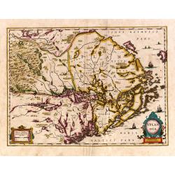
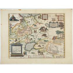
Uplandia.
Covers the area of the modern Uppsala, the vicinity of Stockholm, and includes most of Aland.
Date: Amsterdam, 1639
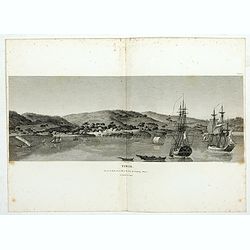
Timor. Vue de la rade, de la ville et du fort de Coupang, dans l'île de Timor.
Nice double page view of the town Kupang, formerly known as Koepang. In the center is the Dutch V.O.C. fort. From Voyage de découvertes aux terres Australes by François P...
Date: Paris, 1807-1816
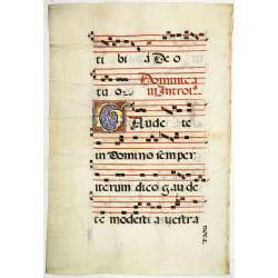
Leaf on vellum from an antiphonary.
A very fine antiphonary leaf, written in Latin, probably Rome. RECTO: A wonderful initial "I" decorated with penwork in red, white and blue, in rich burnished g...
Date: Italy, 1480
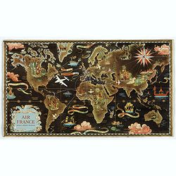
AIR France réseau arérien mondial.
Original lithograph advertising planisphere cardboard from AIR France. The map is designed by Lucien Boucher and is in fact a reduced version of his larger format poster....
Date: Imprimerie Perceval, Paris, 1938
Ceuta Ville d'Afrique au D'estroit de Gibraltar.
A very RARE panoramic view of the city of Ceuta, including a numbered legend in both lower corners.Published by the brothers Chéreau, active in Paris at rue st.Jacques au...
Date: Paris c.1720
Esquisse de la Baie de Coupang (cote S.O. Ile de Timor) par M. M. Peron et Lesueur, an 1803.
Map of Kupang Bay on the Indonesian Island Timor, prepared by Louis Freycinet during his voyage under Captain Thomas Baudin in 1800-1803. Plate no. 14 from the atlas part...
Date: Paris, Langois, 1811
![[Lot of 9 maps] Plan général de Sébastopol avec indication des travaux du siege et de la defense au 28 mars - 9 avril 1855. Feuille 10. xiii](/uploads/cache/33907-250x250.jpg)
[Lot of 9 maps] Plan général de Sébastopol avec indication des travaux du siege et de la defense au 28 mars - 9 avril 1855. Feuille 10. xiii
A group of nine (of 14) very rare panoramic town-plans of the siege of Sebastopol or maps of the Crimea. In lower margin : "Gravé au Dépôt topographique de la Guerre...
Date: St. Petersburg, N. Thieblin, 1863
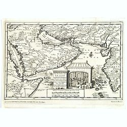
De kusten van Arabie het Roode Meer en Persize Zee..
Map of the Arabian Peninsula till West Coast of India, southern Persia and the 'Horn of Africa'. Although not renowned for the originality of his work, Pieter van der Aa ...
Date: Leiden, 1707
Leaf on vellum from a printed Book of Hours.
24 lines of printed text, surrounded by Renaissance borders decorated with scenes and figures.The firm of Thielman Kerver is best known for its lovely printed Books of Ho...
Date: Paris, Philippe Pigouchet for Simon Vostre, ca. 1502
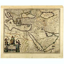
Turcicum Imperium.
A very handsome map featuring a particularly fine cartouche that depicts the Turkish Sultan on his throne, accompanied by allegorical figures on either side, brandishing ...
Date: Amsterdam, 1650
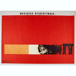
Ministry of health warned . . .
Uncommon Soviet propaganda poster against tobacco consumption.Read more about the Soviet propaganda poster. [+]
Date: Moscow, 1988
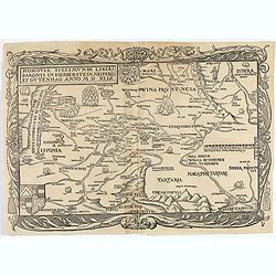
Moscovia Sigismundi Liberi Baronis In Herberstein, Neiperg et Gutehnag Anno M.D XLIX
First Modern Map of Russia. A rare and important cornerstone map for any Russian collection.One of two maps of Russia compiled by Herberstein, who was ambassador from the...
Date: Basle, 1556
![[Title page for] Theatrum Orbis Terrarum.](/uploads/cache/47940-250x250.jpg)
[Title page for] Theatrum Orbis Terrarum.
A decorative title page of the first atlas ever made shows five female figures as allegorical representatives of the continents, grouped around the title. According to P...
Date: Antwerp, after 1570
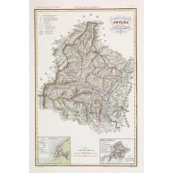
Divisione Militare di Novara. Pallanza / Ossola.
Very finely engraved and detailed map of the region of Novara, including Lago Maggiore to the right. Lower corners, two inset plans of Pallanza and Ossola. Upper right co...
Date: Rome, 1860
![Terre de Diemen. Habitations. [plate XV].](/uploads/cache/46278-250x250.jpg)
Terre de Diemen. Habitations. [plate XV].
An aboriginal campfire, near the ruins of an old wooden fence, and a dead tree, after the original sketches by Lesueur, from Voyage de découvertes aux terres Australes by...
Date: Paris, 1824
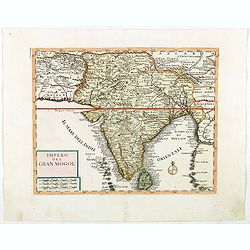
Impero del Gran Mogol.
Attractive copper engraved map of India with Sri Lanka. Showing mountains, towns and the Rama's Bridge (Ponte di Adamo). Included in "Atlante Novissimo che Contiene ...
Date: Venice, 1740
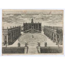
Capitolii sciographia ex ipso exemplari Michaelis Angeli Bonaroti a Stephano Duperac Parisiensi accurate delineata…
View of the Roman Capitol as re-designed by Michelangelo, from "Speculum Romanae Magnificentiae", first published in 1569, this example edited by Giovanni Orlan...
Date: Rome, Orlandi, 1602
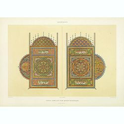
Arabesques. - Pages jumelles d'un qorân mauresque. (XVIIIe siècle)
Lithographed by Daumont. From the author's "L'Art Arabe d'après les monuments du Kaire…". Emile Prisse d'Avennes, an Orientalist and Muslim convert with obsessi...
Date: Paris, 1877
![[Title page from ] Le Theatre du Monde ou le nouvel atlas mis en lumière par Guillaume et Jean Blaeu. La seconde partie de la premiere.](/uploads/cache/47929-250x250.jpg)
[Title page from ] Le Theatre du Monde ou le nouvel atlas mis en lumière par Guillaume et Jean Blaeu. La seconde partie de la premiere.
Frontispiece of the second part of the first part of this fine atlas. At top, a coat of arms surmounted by a crown and surrounded by two golden chains, the bigger carryin...
Date: Amsterdam, 1644
![Hausse-col militaire des insulaires de la Mer du Sud. [Tome II Pl. 12.]](/uploads/cache/26095-250x250.jpg)
Hausse-col militaire des insulaires de la Mer du Sud. [Tome II Pl. 12.]
Maori warrior rise-collar. From the French edition of James Cook's first voyage entitled Relation des voyages entrepris par ordre de sa Majesté Britannique actuellement r...
Date: Paris, 1773
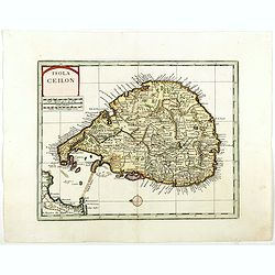
Isola Ceilon.
Attractive copper engraved map of Sri Lanka showing mountains, Towns and the Rama's Bridge (Ponte di Adamo). Included in "Atlante Novissimo che Contiene Tutte le Par...
Date: Venice, 1740
Tabula chronologica historiae Sinicae connexa cum cyclo qui vulgo Kia Tse dictur.
A set of two sheets of colored copper engravings. First published in 1729 in Rome in three sheets. Timeline of China's history with a chronological overview of the dynast...
Date: Augsburg, 1746

Kaart van Het Noordelijk Gedeelte Van Het Eiland Borneo.
A very detailed map of Northern Borneo including Brunei, taken from the "Atlas der Nederlandsche bezittingen in Oost-Indië", which was published by Departement ...
Date: The Hague, 1883-1885

Kaart der Moluksche eilanden en vaarwateren … F.A.A. Gregory Luitenant ter zee …
Huge sailing chart centered on the Moluccas Islands. Published by Widow Gerard Hulst van Keulen.The publishing house van Keulen, were the most prominent chart makers at ...
Date: Amsterdam, 1847
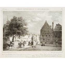
View in Albany-House of the first Dutch Governors.
Decorative print after Jacques Milbert, and lithographed by Tierpenne and the figures by Victor Adam.From Amérique Septentrionale. Printed by de Bove and Noöl ainé &C...
Date: Paris, 1829
Russiae, Moscoviae et Tartariae Descriptio.
Engraved by Frans Hogenberg from an original of 1562 by Anthony Jenkinson of the English Muscovy Company. The many vignettes are based on the reports of Marco Polo's expl...
Date: Antwerp, 1598
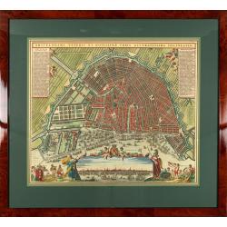
Amstelodami veteris et novissimae urbis accuratissima deline
A decorative plan of the town with legends on the left and right mentioning the most important buildings and streets. At bottom center a view of the town from 't IJ. From...
Date: Amsterdam, 1745-1754
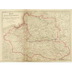
Carte des Etats de Pologne et du Grand Duché de Lithunanie.
Uncommon map of Poland prepared by Sanson and revised by Eustache Hérisson (1759-18.. ) and engraved by Cordier. The map was published by the last family member of the Je...
Date: Paris, Jean, 1831
![[Pictorial map of Georgia (Caucasus)].](/uploads/cache/47135-250x250.jpg)
[Pictorial map of Georgia (Caucasus)].
A scarce pictorial map of a region in Georgia in the Caucasus. Map is entirely in Russian, complete with legend at base of map, with small thumbnail pictures and symbols ...
Date: Moscow, 1963

D. Cassini. Né en 1625. mort en 1712.
Very rare stipple engraved portrait of Jean Dominique Cassini. Dominique Cassini was the son of César-François Cassini de Thury, the grandson of Jacques Cassini and the g...
Date: Paris, ca. 1750
