Popular Listings

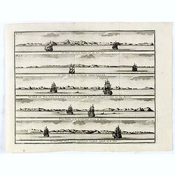
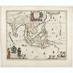
Indiae extra Gangem Pars Septentrionalis. Indiae extra Gangem Pars Meridionalis.
The map on the left depicts the northern portion of the India Ganges region, representing Burma (Myanmar), Thailand, Cambodia, Vietnam and Laos. The right one depicts th...
Date: Utrecht / Amsterdam, J.Halma, 1683
![Vue de l'Isle d'Otahiti et de plusieurs Pirogues. [Tome II Pl. 11.]](/uploads/cache/26102-250x250.jpg)
Vue de l'Isle d'Otahiti et de plusieurs Pirogues. [Tome II Pl. 11.]
View of the Island of Tahiti and dugouts. From the French edition of James Cook's first voyage entitled Relation des voyages entrepris par ordre de sa Majesté Britannique...
Date: Paris, 1773
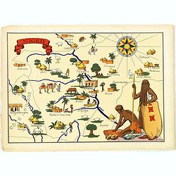
Niger.
Very decorative, informative map of Nigeria. The map is filled with buildings, animals, figures and two locals. With a large compass rose in upper right corner.In lower l...
Date: France, 1943
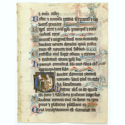
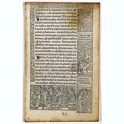
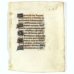
Illuminated leaf from a liturgical Psalter.
Very fine illuminated leaf from a liturgical Psalter in Latin with the reading from the Vulgate Bible. Lines in a slightly irregular Gothic hand, written in black ink, wi...
Date: England, c. 1280
Selling price: ????
Please login to see price!
Sold in 2025
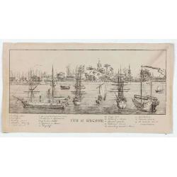
View of Singapore
Very rare view of Singapore from the Singapore River Basin. With a numbered key (1-19) underneath the illustration. In the center Government Hill with Governer's House (1...
Date: ca. 1850

Kaart van de Reede van Batavia met de verschillende vaarwaters naar dezelve trigometrisch opgenomen op last van deb schout bijnacht E.Lucas.
Very large and rare so-called blue-black chart centered on Jakarta's harbor.The chart is prepared by B.G.Escher, I.A.C. Eschauzier, B.H.Staring and E.H.Boom during an exp...
Date: Amsterdam (1841) 1847
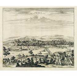
Terki, ville de la Circassie, dans l'Asie.
A very detailed panoramic view of Terki in the Caucasus, the capital of one of the most powerful Dagestani potentates of southeast Asia.Showing the Volga River.The town o...
Date: Leiden, c. 1719
De Kust van Nova Guinea tot aan deze bogt . . .
De kust van Nova Guinea tot aan deze bogt.De Kust van Nova Guinea ofte Salomon Sweers hoek. Het Landt van Nova Guinea in de Groote Bocht daar wy vergeefs hoopten een doo...
Date: Amsterdam, 1726
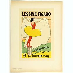
Lessive Figaro.
Chromo lithographed poster of Les Maîtres de l'Affiche being plate n°71. The "Les Maîtres de l'Affiche" contained 256 small for lithographic prints of the best ...
Date: Paris, Imprimerie Chaix, 1896
![[The Admiralty Islands and New Britain inhabitants fishing. Papua New Guinea ].](/uploads/cache/26365-250x250.jpg)
[The Admiralty Islands and New Britain inhabitants fishing. Papua New Guinea ].
Aquatint depicting fishermen in dugouts engraved by A. Biasioli. Plate N° 14. From Giulio Ferrario's work Le Costume Ancien et Moderne ou Histoire du gouvernement, de la ...
Date: Milan, 1827
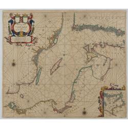
Oost Zee door Arnold Colom.
Large double-page engraved chart of the Baltic Sea, including the coastlines of Finland, Estonia, Latvia, Lithuania, Poland, Denmark, and Sweden, with a decorative inset ...
Date: Amsterdam, c. 1654
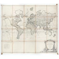
Mappemonde ou carte générale du globe terrestre dessinée suivant les règles de la projection des cartes réduites…
Large world map showing the sea tracks of Captain Cook in his three Pacific voyages published by C. F. Delamarche.Rare state 4, dated 1786, of this large world map, featu...
Date: Paris, Robert de Vaugondy/Delamarche, 1786
Leaf on vellum from a printed Book of Hours In Latin and French.
24 lines of printed text, surrounded by renaissance borders decorated with flowers, vases and figures. Gothic type, text in Latin, numerous one and two-line initials in g...
Date: Paris, Germain Hardouyn, c. 1520-1540
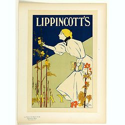
Lippincott's, May.
Chromo lithographed poster of Les Maîtres de l'Affiche being plate n°44. The "Les Maîtres de l'Affiche" contained 256 small for lithographic prints of the best ...
Date: Paris, Imprimerie Chaix, 1896
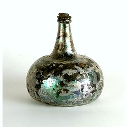
Wine bottle
The Onion-shaped wine bottle is of green glass and is sealed with cork and wax that the cork holds in place. The many years that the bottles spent under the water have l...
Date: Dutch East India Company, Netherlands, ca. 1735-1750
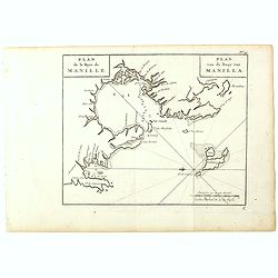
Plan de la Baye de Manille. / Plan van de Baay van Manilla.
Detailed plan of Manila Bay after George Anson's key plan of the Bay of Manila. With a compass rose and soundings in the Bay. East to the top.This is the rare Dutch editi...
Date: Amsterdam, Arkstee and Merkus, 1751
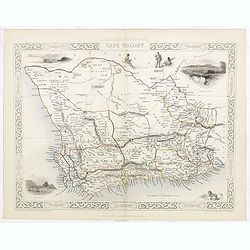
Cape Colony.
A decorative steel engraved map from the famous Victorian publisher John Tallis and Company, published ca.1851. Drawn and engraved by J Rapkin, while the four corner vign...
Date: London, Edinburgh, Dublin, 1851
![Timor. Canda Jeune fille Malaise. [plate XXVI]](/uploads/cache/46348-250x250.jpg)
Timor. Canda Jeune fille Malaise. [plate XXVI]
A portrait of a female Canda by Lesueur, from Voyage de découvertes aux terres Australes by François Péron, 1824.The French expedition under Nicolas Baudin, was commissio...
Date: Paris, 1824

Het Klooster ten Hage (Marienhage Eindhoven)
Very rare lithography of the ruin of the monastery of Ten Haghe in Eindhoven. Lithographed by M.Mouret, published in "oud-Nederland en de uit vroegere dagen overgebl...
Date: Nijmegen, 1837-1846

Zelandia Comitatus.
Based on the map by Van Deventer. For the first time a road connection between Flushing, Middelburg and Arnemuiden is shown. Mercator pays much attention to the area of s...
Date: Amsterdam, 1630
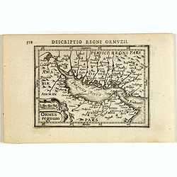
Descriptio Regni Ormuzii / Ormus.
A lovely miniature map of the Kingdom of Ormus, published by Petrus Bertius, and published in Amsterdam at the beginning of the seventeenth century. With an attractive st...
Date: Amsterdam, 1606
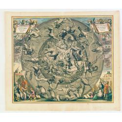
Hemisphaerii Borealis Coeli et Terrae Sphaeri Cascenographia.
A finely executed celestial chart of the Northern Sky, illustrating the constellations of the Northern Hemisphere superimposed over the Pacific Ocean, first published by ...
Date: Amsterdam, 1661
Selling price: ????
Please login to see price!
Sold in 2025

India Orientalis.
Published in Hondius' editions of the Mercator Atlas from 1606 onwards, showing the Indian subcontinent, the Malay Peninsula, Siam and Cambodia, China and the Philippines...
Date: Amsterdam, 1630

Karte der Ukraina.
A large political, economical and transportation map of Ukraine, printed three months after the beginning of the WW II in Ukraine. Shows the newest borders, streets and r...
Date: Vienna: Freytag u. Bernd u. Artaria August 1941
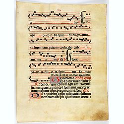
Leaf on vellum from a antiphonary.
A leaf from a Medieval Antiphonal or Choir Missal for Spanish use, in Latin on extremely heavy vellum. Justification: 360x246mm. Text is in Spanish rounded gothic hand (R...
Date: Sevilla, ca.1520
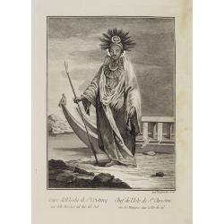
Capo dell' Isola di S.a Cristina una delle Marchesi nel Mar Pacifico del Sud. / Chef de l'Isle de Ste. Christine une des Marquises dans la Mer Pacifique du Sud.
Full portrait of the Chief of the Saint Christina Island. A rare engraving from "Raccolata di stampe ... di varie nazioni". From the original drawing by William...
Date: Venice, Antonio Zatta, c.1790

La Floride. . .
The map is derived from La Floride , 1657, by Nicolas Sanson. Several new rivers appear in Virginia. The Caroline listed is Ft. Caroline, not the Carolinas. The Florida n...
Date: Paris, 1683
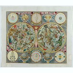
Planisphaerum coeleste.
A very decorative double hemisphere celestial chart. The 10 smaller circular diagram showing the rotation of the Planets, according to Tycho Brahe, Ptolemy and Copernicus...
Date: Nurenberg, 1750
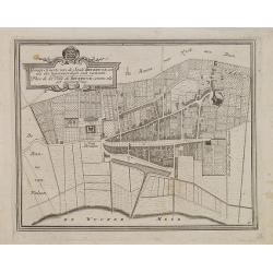
Gemete Kaerte van de Stede Beverwyk, zoo als die tegenwoordigh zich vertoont.
Uncommon plan of Beverwijk made in the year 1739. Published in Hollandsche Arcadia. Title in Dutch and French.
Date: Amsterdam, ca.1740
![[Tartary - Russia]](/uploads/cache/44310-250x250.jpg)
[Tartary - Russia]
Postcard size map in Ottoman script showing Siberia prepared by Mehmet EŞREF in a small atlas : عمومولاياةىشهانيىحاوىكوچكاطلاس [Umum-i vilayat-ı Şahaneyi havi küçük ...
Date: Istanbul, 1325 or 1909
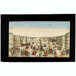
Imaginary view of a square with Muslims festival.
Imaginary view of a square with Muslims festival. A so called optical print.
Date: Paris, ca. 1750
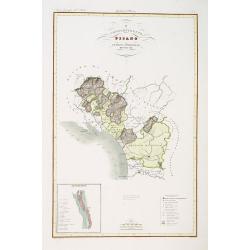
Compartimento Pisano.
Very finely engraved and detailed map of the territory of Pisa, including the region of Lucca and Estense. Lower left corner, an inset plan of Pontremoli. In the lower ri...
Date: Rome, 1860

The new woman . . .
Chromo lithographed poster of Les Maitres de l'Affiche n°79. The "Les Maitres de l'Affiche" contained 256 small for lithographic prints of the best posters of t...
Date: Paris, Imprimerie Chaix, 1896
![[Title page from Theatrum orbis Terrarum, with past-on]](/uploads/cache/43860-250x250.jpg)
[Title page from Theatrum orbis Terrarum, with past-on]
The frontispiece of the third part of the 'Theatrum', by Johan Blaeu. Heightened with goldDecorated with terrestrial and celestial globes and to the left Ptolemy (with sp...
Date: Amsterdam, ca. 1650

Tierra Nueva.
Uncommon first edition of this early map of the east coast is an enlarged version of Giacomo Gastaldi map published in 1548. Nomenclature and cartography are unchanged, w...
Date: Venice, 1561
![[Title page] Geographiae libri octo Graeco-Latini . . .](/uploads/cache/47936-250x250.jpg)
[Title page] Geographiae libri octo Graeco-Latini . . .
Fine decorative titlepage from the 1605 edition of Ptolemy. The plate is adorned with allegorical figures, fruits and architectural motifs. This 1605 edition was based on...
Date: Amsterdam, 1605
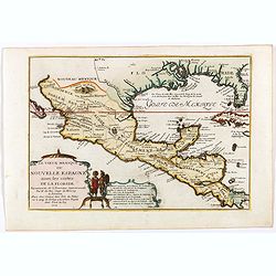
Le vieux Mexique ou nouvelle Espagne. . .
Attractive map covering the Gulf of Mexico through Central America also including parts of Cuba and Jamaica. It extends through Mexico to show the southern tip of Baja Ca...
Date: Paris, 1705
![[Tableau Général de l'Empire Ottoman]. 11 plates with the panoramic view of Mecca.](/uploads/cache/41513-250x250.jpg)
[Tableau Général de l'Empire Ottoman]. 11 plates with the panoramic view of Mecca.
A collection of 11 engraved plates (3 folding) from "Tableau Général de l'Empire Ottoman", Paris, Imprimerie de Monsieur, 1790, comprising the famous panoramic ...
Date: Paris, 1790
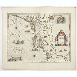
Nova Belgica et Anglia Nova.
The first Dutch settlers arrived in 1614 and settled at Fort Nassau (located near the Port of Albany).Oriented with north to the right. This is one of the earliest maps t...
Date: Amsterdam, 1644

Lenin October.
Uncommon Soviet propaganda poster.Read more about the Soviet propaganda poster. [+]
Date: Moscow, 1987
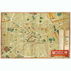
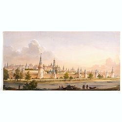
Moscow.
Fantastic pictorial map of Moscow designed to draw tourists to the new Soviet Union.The cultural vitality of Moscow in the early years of the Soviet Union is the focal po...
Date: Moscow, c. 1938
![Donna dell' Isola di Mallicolo una delle nuove Ebridi nel Mar Pacifico del Sud. / Femme de l' Isle d'Erramanga... [Vanuatu]](/uploads/cache/26397-250x250.jpg)
Donna dell' Isola di Mallicolo una delle nuove Ebridi nel Mar Pacifico del Sud. / Femme de l' Isle d'Erramanga... [Vanuatu]
Full portrait of a woman, a native of the island of Mallico in the New Hebrides, officially the New Hebrides Condominium, the colonial name for the island group in the So...
Date: Venice, Antonio Zatta, c.1790

Tabula ducatus Limburch et comitatus Valckenburch. . .
The map describes the southern part of Limburg and reaches into Belgium (Liege, Verviers) and Germany. With two very decorative cartouches.
Date: Amsterdam, 1690
![[Concert at time of Handel] Dulcissimum Melos Bona Fama.](/uploads/cache/47201-250x250.jpg)
[Concert at time of Handel] Dulcissimum Melos Bona Fama.
Copper-plate engraving of the rehearsal of a chamber cantata by Johann Christoph Steudner, after Paul Decker the elder, in the Handel-Haus, Halle. (Musikgeschichte in Bil...
Date: Augsburg, 1700

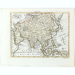
Asia.
Uncommon map of Asia. Engraved by Marco di Pietro.The map is of interest for the use of G. di Corea, for the sea between Korea and Japan.Published by Carlo Antonio Barbie...
Date: Milan, 1807

Curia Hollandiae Interior. (Binnenhof)
The government center of the Netherlands is situated in and around the Binnenhof-Buitenhof in The Hague. In 1248, the Roman king Willem II built a castle here and named i...
Date: Amsterdam, 1649
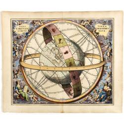
Situs Terrae Circulis Coelestibus circundatae..
A celestial chart depicting a large globe centered on Australia and the Pacific, with California depicted as an island, and South East Asia encircled by the zodiacal band...
Date: Amsterdam, Janssonius, 1660
Caarte vande nieuwe Passagie bezuijden de Strate Magellan. . . / Description de nouveau passage vers le zud du destroit de Maggellan. . .
Map showing the new route around the bottom of South America discovered by Schouten and Le Maire: through the Le Maire Strait, around the Barnevelt Islands, and past Cape...
Date: Frankfurt am Main, 1619

Carte générale de l' Amérique divisée en ses principaux états . . .
Map of North and South America. By C. F. Delamarche, successor of Robert de Vaugondy, Geographer. Descriptive text to the left.
Date: Paris, 1820
![[Women dancing in a Ulietea house ].](/uploads/cache/26376-250x250.jpg)
[Women dancing in a Ulietea house ].
Aquatint depicting women dancing in front of musicians and local villagers in a Ulietea house. Plate N° 87. From Giulio Ferrario's work Le Costume Ancien et Moderne ou Hi...
Date: Milan, 1827
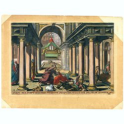
Domus mea domus orationis vocabitur. Joan 10.
A superb example of this illustration from Memorabilium Novi Testamenti in templo gestorum (Events in and around the Temple) (Events in and around the Temple). Christ exp...
Date: Antwerp, 1585
Leaf on vellum from a manuscript Book of Hours.
Charming small manuscript leaf from an French Book of Hours written around 1470 in or near Rouen.VERSO: 14 Lines of text in Latin five 1-lines initial in liquid gold on b...
Date: France, ca.1470
![[Fan shaped shopping guide to Stockholm.]](/uploads/cache/44788-250x250.jpg)
[Fan shaped shopping guide to Stockholm.]
A highly unusual and interesting vintage fan-shaped map of Stockholm to illustrate a 'Shopping guide to Stockholm'. Text written in English. With ten fold-out panels prin...
Date: Stockholm, 1960
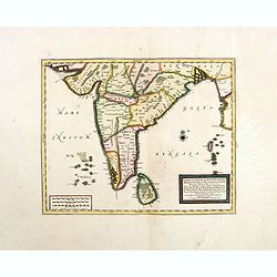
Carte du Golfe de Bengale, Mer de Indes, et Riviere du Gange, Avec les Pais et Iles d'alentour, Savoir les Cotes de Malabar, Cormandel, Ile de Ceylon, Les Maldives . . .
Detailed map of the Southern part of India with Ceylon. Good detail along the coasts of Malabar, Coromandel, the Maldives islands and the Kingdoms of Visipour, Golconda, ...
Date: Leiden, 1719
![Arcis Carolinae delineatio [Jacksonville]](/uploads/cache/48530-250x250.jpg)
Arcis Carolinae delineatio [Jacksonville]
Depicting Fort Caroline in Jacksonville, Florida. A French expedition, organized by Protestant leader Admiral Gaspard de Coligny and led by the French Explorer Jean Ribau...
Date: Frankfurt, 1594
![[World map in showing currents with Ottoman script]](/uploads/cache/44322-250x250.jpg)
[World map in showing currents with Ottoman script]
Post card size world map in Mercator projection showing the currents in Atlantic and Pacific Oceans in Ottoman script prepared by Mehmet EŞREF in a small atlas : عمومولا...
Date: Istanbul, 1325 or 1909
Sic per secta repens venator consista dumis - Torquet et undosos anates, Fusicasp palustres
This is a plate from a series "Venationes ferarum, avium, piscium, pugnae bestiariorum & mutuae bestiarum". Published by Philippe Galle (Haarlem 1537 - 1612...
Date: Antwerp, Philips Galle, ca 1596

Cherries.
Color aquatint and stipple engraved plate of fruits by George Brookshaw (1751-1823) from his "Pomona Britannica; or, a Collection of the most esteemed fruits at pres...
Date: London, Bensley and son, 1817
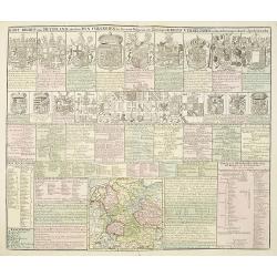
Kort Begryp van Duytsland, de drie Ryx Collegien in hunne Wapens en Zittingen. Kreits Verelingen en Aantekenigen door C. Specht't Utrectht.
Second state of this decorative table of family escutcheons, crests and coats of arms, for various German and Dutch princes and nobles of the 16th, 17th and 18th Centurie...
Date: Amsterdam, 1720
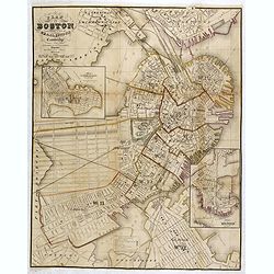
Plan Of Boston Comprising a Part of Charlestown and Cambridge. Published by George G. Smith, Engraver, Washington Street Boston 1855..
Important and detailed plan of Boston, with insets :"Plan Of East Boston from actual Survey by R.H. Eddy" and "Plan Of South Boston From a Drawing by S.P. ...
Date: Boston, ca. 1859
![ИНДIИ [Map of India in Cyrillic].](/uploads/cache/44340-250x250.jpg)
ИНДIИ [Map of India in Cyrillic].
A map of India. This Cyrillic version of the map appeared in one of the first world atlases published in Russia, "Novy Atlas, ili sobranie kart ..." which trans...
Date: Paris / St.Petersburg, ca. 1790
![[Map of the coast of Crete to the east of Chania showing the landing of the Turks and the Venetian defence in June 1645].](/uploads/cache/49076-250x250.jpg)
[Map of the coast of Crete to the east of Chania showing the landing of the Turks and the Venetian defence in June 1645].
Map engraved by Marco Boschini (1613-1678). With a lettered key for the Turkish army « A-L » and a numbered key for the city of Chania and its army « 1-20 ».Fifth Otto...
Date: Venice, c. 1645

The Wonderground Map of London.
A large and pictorially striking 'Wonderland' advertising poster on behalf of the London Underground, published in the late 1920s. The poster was very popular, and ran fo...
Date: London, 1927
Waschinga Sahba's Grab.. (Wakonda Creek.)
Original aquatint engraving for Travels in the Interior of North America between 1832-34 . Engraved by Ch. Vogel. The finest work on American Indian life and the American...
Date: London/ Paris/ Coblenz, 1839
India quae Orientalis dicitur, et insulae adiacentes.
Extending from India to Japan and showing parts of Australia. It is indeed one of the first printed maps to show identifiable parts of Australia. It was not revised until...
Date: Amsterdam, 1644
Asia.
Detailed map the Asian continent. The map is of interest for the use of Sea of Corea, the sea between Korea and Japan.
Date: Amsterdam, 1682
Selling price: ????
Please login to see price!
Sold in 2023

Vidit David de Solario Domus regiae Bethsabeam . . . ( Plate 44)
Fine etching by Nicolas Chapron, after Raphaël's (Raffaello Sanzio) frescoes in the Vatican Loggia. Scene illustrating King David looking at Bathsheba bathing.From the fi...
Date: Paris, Petrus Mariette, 1649
![[Lot of 2 leaves] Vienna Austriae metropolis, urbs…](/uploads/cache/48268-250x250.jpg)
[Lot of 2 leaves] Vienna Austriae metropolis, urbs…
1552 MÜNSTER, S. - Two early panoramic views of Vienna on a text page.
Date: Basel, 1552
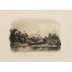
(View of the Moscow Kremlin, seen from the Moskva River in the south).
Anonymous, likely Russian School gouache drawing of Moscow Kremlin. The Kremlin is depicted in a typical 19th century romantic style and is seen from the Moskva river in ...
Date: Russia, ca. 1850

Wassende graade paskaart vertonende alle de Zeekusten van Europa, de geheele middelandsche Zee…
Wassende graade paskaart vertonende alle de Zeekusten van Europa, de geheele middelandsche Zee, als cock ten Noordwesten, en Noordoosten soo veer als ons tot noch toe bek...
Date: Amsterdam, 1658

Pascaarte, van de Zuijderzee, Vliestroom, Vlie, en Amelandergat…
Very rare chart of the Dutch Zuiderzee, here in its rare 5th state (o f6). Showing the coastlines along the Dutch inner sea. Two compass roses indicate north to the left ...
Date: Amsterdam, c. 1660

Carte des Possessions Françoises et Angloises dans le Canada, et partie de la Louisiane.
First state of this separately published map of the European Colonies in the New World east of the Mississippi River. This map was published in 1756 to provide informatio...
Date: Paris, 1756
![[Marquesas Islands headdresses and head ornaments ].](/uploads/cache/26374-250x250.jpg)
[Marquesas Islands headdresses and head ornaments ].
Aquatint depicting Marquesas Islanders in traditional headdresses and a variety of head ornaments engraved by Bonatti. Plate N° 90. From Giulio Ferrario's work Le Costume...
Date: Milan, 1827
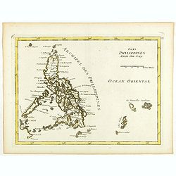
Isles Philippines.
Fine map of the Philippines. George Louis Le Rouge was active from 1740- till 1780 as a publisher, and was appointed engineer for the King of France. From his Atlas Nouve...
Date: Paris, 1756
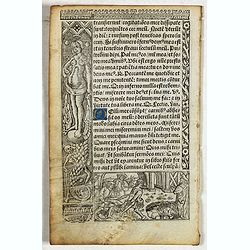
Leaf on vellum from a printed Book of Hours.
24 lines of printed text, surrounded by Renaissance borders decorated with flowers, vases, skeletons and religious scenes.From the press of the leading Parisian publisher...
Date: Paris, Germain Hardouyn, c.1520-1540
![[HAWAII] - Plan de la baye de Karakakooa.](/uploads/cache/48173-250x250.jpg)
[HAWAII] - Plan de la baye de Karakakooa.
Beautiful map showing the islands forming the Hawaiian archipelago, drawn up during Cook's third voyage: Oneeheow or Ni'ihau, Atooi or Kauai, Woahoo or O'ahu, Morotoi or ...
Date: Paris, 1774
Ducato di Lucca.
Very finely engraved and detailed map of the region around Lucca. Lower part of the map, two inset lists of the mountains height and the local minerals. Engraved by Vetto...
Date: Rome, 1860

Chosen Danpan - Korean negotiation.
A scene of a Japanese legation under the command of Hanabusa Yoshitada who is forcing the Korean King Kojong (1852-1919) to agree to Japanese demands during the Chemulpo ...
Date: August 8, MEIJI 27th year or 1894
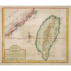
L'Isle Formose et parties des Costes de la Chine. . .
This well-known map of Taiwan was prepared by Jacques Nicolas Bellin and was based on Jesuit information. The text along the island's east coast claims: Of this coast, li...
Date: Paris, 1763
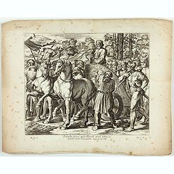
Svbacta Syria, tvlit David arma avrea, et detvlit ea in Jervsalem. ( Plate 43)
Fine etching by Nicolas Chapron, after Raphaël's (Raffaello Sanzio) frescoes in the Vatican Loggia. Scene illustrating David's conquest of Syria, during which he took the...
Date: Paris, Petrus Mariette, 1649
