Popular Listings
![[Title page for ] Atlas de la Terre ou Monde Terrestre - Tome premier]](/uploads/cache/47761-250x250.jpg)
[Title page for ] Atlas de la Terre ou Monde Terrestre - Tome premier]
Title page of " Atlas de la Terre ou Monde Terrestre - Tome premier" by J. Jansonius. This is the updated version of 1:42B. The figures of the king, queen, daup...
Date: Amsterdam, after 1650
![[New Caledonians ].](/uploads/cache/26367-250x250.jpg)
[New Caledonians ].
Aquatint depicting New Caledonians engraved by Biasioli. Plate N° 71. From Giulio Ferrario's work Le Costume Ancien et Moderne ou Histoire du gouvernement, de la milice, ...
Date: Milan, 1827

L'Homme A La Boule.
Satirical print in which Count Otto von Bismarck balances on the world with one spurred foot entering France, and wearing only his underpants which are marked with the Ge...
Date: Paris, 1870-1871

Vue et perspective de la ville de Marseille et ses environs, prise du côté de la belle vue de la plaine St. Michel. Dediée à S. A. S. Mgr. le duc de Penthievre Grand Amiral de France. Par son très humble et très obéissant Serviteur Aulagnier.
Scarce large and spectacular panorama of the city and harbour of Marseille published in Paris in the middle of the 18th century. Engraved by Pierre Jacques Duret under th...
Date: Paris, 1751
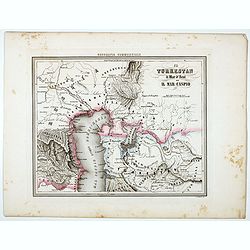
Il Turkestan il Mar d'Aral ed il Mar Caspio.
Uncommon map of Turkestan with the Northern part of the Caspian Sea, with part of present-day Uzbekistan in the lower right corner. in the prepared by Francesco Costanti...
Date: Genova, Paolo Rivara fu Giacomo, 1858
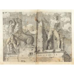
Opus Praxitelis, Opus Fidiae.
Opus Praxitelis, Opus Fidiae [Work of Praxiteles, Work of Fidias]. With the Lafreri's imprint and date. Published in the "Speculum Romanae Magnificentiae" (The ...
Date: Rome, Antonio Lafreri, 1546
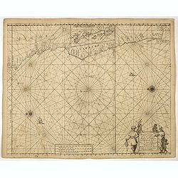
Pascaart van de zee-custenvan Angola, en Cimbedas van Rivier de Galion tot C. de Bona Esperanca.
Rare Doncker's sea chart of the West Coast of Africa, from Angola to the Cape of Good Hope, with a larger inset map of the area from St. Martin's Bay to the Cape of Good ...
Date: Amsterdam, 1660-1668
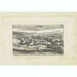
Sigeth.
Panoramic view of Sigeth. Published in "Der Donau-Strand Mit allen seinen Ein- und Zuflüssen. . .". Published by Jacob Sandrart.
Date: Nuremberg, Jacob Sandrart, 1684
![[Isothermal Linti].](/uploads/cache/46152-250x250.jpg)
[Isothermal Linti].
A detailed map from Учебный Географический Атлас published by the very successful St. Petersburg publisher "Cartographic institution A.Ilina" ("Картографич...
Date: St. Petersburg, 1899

Woman of Brabant.
Very fine view of a woman wearing the traditional dress of Brabant.
Date: London, 1817

Udrone.
Map depicting present-day County Carlow in Leinster Province & Catherlaugh which is now Carlow. From the first French-text edition of Jodocus Hondius' Atlas Minor.Sho...
Date: Amsterdam, 1608

Map of Pensylvania and New Jersey by H.S. Tanner.
First edition of this rare and important map of Pennsylvania and New Jersey by H.S. Tanner and published in his "New American Atlas" from 1823. Includes roads, ...
Date: Philadelphia, Henry Tanner, 1823
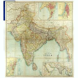
Thacker's Reduced Survey Map of India.
Thacker's reduced Survey Map of India prepared by John Bartholomew and published n Calcutta by Thacker, Spink, & Co. And W. Thacker & Co. in London in 1914.This e...
Date: Calcutta: Thacker, Spink, & Co./ London : W. Thacker and Co., 1914
![[Title page] La Sphere Royale.](/uploads/cache/48022-250x250.jpg)
[Title page] La Sphere Royale.
Title page from Nicolas de Fers "La Sphere Royale", published in 1717. Showing a sphere, surrounded by Neptune, Europe, the elements and scholars.
Date: Paris, 1717
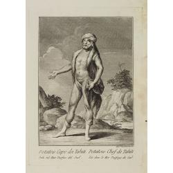
Potatow Capo dei Tahiti Isola nel Mare Pacifico del Sud. / Potatow Chef de Tahiti Isle dans la Mer Pacifique du Sud.
Full portrait of the Hawaiian chief Potatow. A rare engraving from "Raccolata di stampe ... di varie nazioni". From the original drawing by William Hodges, who...
Date: Venice, Antonio Zatta, c.1790
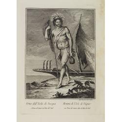
Uomo dell' Isola di Pasqua o Terra di Davis nel Mar del Sud. / Homme de l' Isle de Pâquesou Terra de Davis dans la Mer du Sud.
Full portrait of a native from Easter Island. Easter Island, a Chilean territory, is a remote volcanic island in Polynesia.From "Raccolta di stampe," a series o...
Date: Venice, Antonio Zatta, c.1790
![[Title page from ] Le Theatre du Monde ou le nouvel atlas mis en lumière par Guillaume et Jean Blaeu.](/uploads/cache/47924-250x250.jpg)
[Title page from ] Le Theatre du Monde ou le nouvel atlas mis en lumière par Guillaume et Jean Blaeu.
Frontispiece of the second part of this fine atlas. At top, a coat of arms surmounted by a crown and surrounded by two golden chains, the bigger carrying a pendant which ...
Date: Amsterdam, 1644
![[Rain Distribution].](/uploads/cache/46151-250x250.jpg)
[Rain Distribution].
A detailed map from Учебный Географический Атлас published by the very successful St. Petersburg publisher "Cartographic institution A.Ilina" ("Картографич...
Date: St. Petersburg, 1899
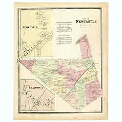
Town of New Castle. Westchester Co. NY.
Fine lithographed map of the town of New Castle. The map provides the names of specific homeowners, as well as information about the occupations and physical locations of...
Date: New York, 1867
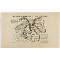
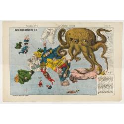
L'Impero della preda ossia la Piovra d'Absburgo.
Austro-Hungarian Octopus zinc lithographed map. A propaganda sheet attacking the Austro-Hungarian Empire, showing it as an octopus with its tentacles wrapped around the v...
Date: La Zincografia, Milan, c. 1915
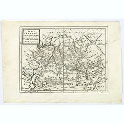
Great Tartary, with the tract of the Moscovite Ambassador's Travels from Moscow to Pekin in China.
An interesting map illustrating the route taken by the Russian Ambassador on his travels east to Beijing. Shows the Great Wall, "Somer Houses" and "parts u...
Date: London, 1732
![[ North and South America with telegraph cables, with Ottoman script]](/uploads/cache/44330-250x250.jpg)
[ North and South America with telegraph cables, with Ottoman script]
Postcard size map showing North and South America with telegraph cables. The map is in Ottoman Arabic-script prepared by Mehmet EŞREF in a small atlas : عمومولاياةىشهاني...
Date: Istanbul, 1325 or 1909
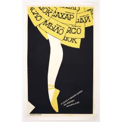
Russian Perestroika Ballet Poster.
Wonderful and delicate Russian Perestroika poster depicting a ballerina. On the frills of her skirt, there are several messages written down, which mean « a coupon for su...
Date: Russia, 1990
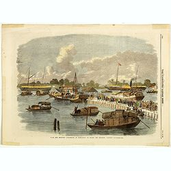
Sick and wounded embarking at Hong-Kong on Board the Steamer.
Large view of the harbour with numerous ships and people. From the Illustrated London News, October 23, 1858.
Date: London, October 1858
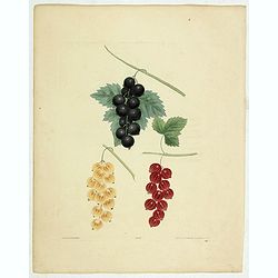
Black, Dutch Red and White Current.
Color aquatint and stipple engraved plate of fruits by George Brookshaw (1751-1823) from his "Pomona Britannica; or, a Collection of the most esteemed fruits at pres...
Date: London, Bensley and son, 1817
Hammond's War Map.
Drawn and published in early 1942 by C. S. Hammond & Co. in direct response to the bombing of Pearl Harbour, this is one of the most detailed USA maps of the Pacific ...
Date: New York, 1943
Cherries.
Color aquatint and stipple engraved plate of fruits by George Brookshaw (1751-1823) from his "Pomona Britannica; or, a Collection of the most esteemed fruits at pres...
Date: London, Bensley and son, 1817
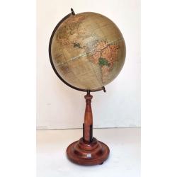
Prof. Dr. A. Krause, Neuer Handels- u. Verkehrsglobus, Verlag Paul Räth.
Art-Deco German Table Globe, on a scale of 1:38 600 000, designed by Prof. Arthur Krause with 30 centimeters in diameter, made by the company Paul Räths, Nachf. KG, Leipz...
Date: Leipzig, Paul Räth, ca. 1930
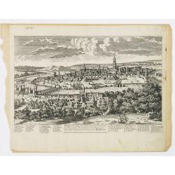
![Madeburga [ Maagdenburg Folio CLXXX ]](/uploads/cache/12338-250x250.jpg)
Madeburga [ Maagdenburg Folio CLXXX ]
Double-page panoramic view of Magdeburg. An imaginary view, however, the earliest obtainable view of this period.Two pages from the richest illustrated Incunable, the fam...
Date: Nuremberg, 12 July 1493
![[Title page] Album delle principali vedute di Venezia disegnate da Marco Moro. . .](/uploads/cache/32269-250x250.jpg)
[Title page] Album delle principali vedute di Venezia disegnate da Marco Moro. . .
The title page has a virgin and the lion of Saint Mark sitting on an island with the background of the town of Venice. Learn more about map printing and views of Venice ...
Date: Venice, G. Brizeghel, ca 1860

Plan du Cap de Bonne-Esperance et ses environs..
Large and detailed sea chart of the Cape of Good Hope from Saldahna Bay to False Bay.Engraved by Guillaume-Nicolas Delahaye (1727-1802).Latitude and longitude scales, com...
Date: Paris, 1745
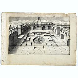
Perspective print by Vredeman de Vries. 40.
Engraving from Perspective, c'est a dire, le tresrenomme art du poinct oculaire d'une veue dedans ou travers regardante, estant sur une muraille unie, sur un tableau, ou ...
Date: The Hague, 1604 - 1605
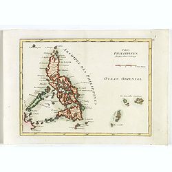
Isles Philippines.
Fine map of the Philippines. George Louis Le Rouge was active from 1740- till 1780 as a publisher, and was appointed engineer for the King of France. From his Atlas Nouve...
Date: Paris, 1756
De Christiana expeditione apud Sinas suscepta ab Societate Jesu, ex P. Matthaei Ricci.
Very rare first edition of the most influential Western description of China since the 13th-century account by Marco Polo. Printed in Latin with an engraved title page in...
Date: Augustæ Vind. (Augsburg), C. Mangium, 1615
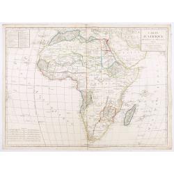
Carte d'Afrique divisée en ses Principaux Etats.
A rare and detailed map of Africa prepared by Jean-Baptiste Poirson (1761-1831). Includes an inset stating the European Possessions in Africa.Deserts are well highlighted...
Date: Paris, chez Jean, An VI 1798
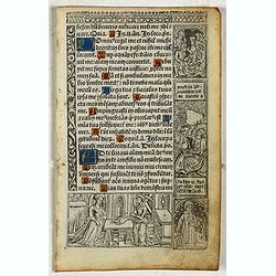
Leaf on vellum from a printed Book of Hours.
24 lines of printed text, surrounded by renaissance borders decorated with flowers, vases and religious scenes.From the press of the leading Parisian publisher and illumi...
Date: Paris, Germain Hardouyn, c.1520-1540
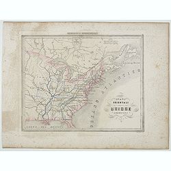
Stati Orientali della Unione Americana.
Uncommon map of Northeastern America prepared by Francesco Costantino Marmocchi. Above the map "Geografia Commerciale". From "Il Globo Atlante di carte Geo...
Date: Genova, Paolo Rivara fu Giacomo, 1858
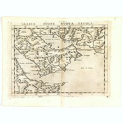
Arabia Felice Nuova Tavola.
Fine early map of Arabian peninsula, being one of the earliest modern maps of the region.Girolamo Ruscelli first published the map in his "La Geographi di Claudio To...
Date: Venice, 1598
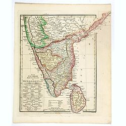
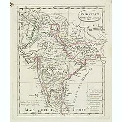
The Southern provinces of Hindoostan . . .
An attractive map showing Hindoostan and Ceylon. Shows towns, rivers, mountains, lakes, etc. In pretty original wash colors. Robert Wilkinson was active in London as a ca...
Date: London, 1808
![Narsinga. [India]](/uploads/cache/38123-250x250.jpg)
Narsinga. [India]
Small map illustrating the Indian peninsular. Oriented with East on top, surrounded by text in Dutch.Nicolaes de Clerck (de Klerc) was active as engraver and publisher in...
Date: Amsterdam, Cloppenburch, 1621
Indostan gia impero del mogol. . .
Charming map of India with Ceylon from the rare atlas Atlante Tascabile o sia Serie di Num. XXI Cartine Geografiche nelle quali si rappresenta in ristretto lo Stato Attua...
Date: Rome, 1823
![Coffre Sculpté des Habitants de la nouvelle Zélande. [Tome III Pl. 13.]](/uploads/cache/26092-250x250.jpg)
Coffre Sculpté des Habitants de la nouvelle Zélande. [Tome III Pl. 13.]
A carved chest of New Zealand, as a specimen of the carving of the country. Engraving drawn after John Frederick Miller (1759-1796). John Frederick Miller was an English ...
Date: Paris, 1773
Seville ville Archiepiscopale et capitale du Royaume d'Andalousie en Espagne. . .
A very decorative and extremely rare town view of Seville, including a numbered key (1-37) in the lower part. Engraved by Pierre-Alexandre Aveline. With "fait par Av...
Date: Paris, ca.1692
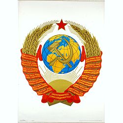
Proletarians of all countries, connect.
Uncommon Soviet propaganda poster.Read more about the Soviet propaganda poster. [+]
Date: Moscow, 1989
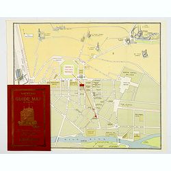
Souvenir Guide Map of Cairo.
A lovely small colored plan of central Cairo, published by Groppi in Cairo. Plan is housed within the original red and gold printed paper covers, with advertisements for ...
Date: Cairo, 1920-1950
Carte Generale de la Terre Napoleon (à la Nouvelle Hollande)... par M.L. Freycinet an 1808.
1811 FREYCINET, M.L. - Part of Australia prepared by Louis Freycinet during his voyage under Captain Thomas Baudin, with a cartouche featuring Napoleon himself
Date: Paris, Imprimerie Royale, 1811
Mer de Chine - Carte des Iles et Détroits entre Singapoure et le Détroit de Banca. Dréssée d'après le stravaux Anglais et Hollandais plus récents, par Mr. L. Manen . . . 1866
A nautical chart of Singapore and neighboring islands. The first edition of the chart was published in 1866 from French and English sources, this is the corrected version...
Date: London, 1866-1871
![[Title page from ] Le Theatre du Monde ou le nouvel atlas mis en lumière par Guillaume et Jean Blaeu. Troisieme partie.](/uploads/cache/47942-250x250.jpg)
[Title page from ] Le Theatre du Monde ou le nouvel atlas mis en lumière par Guillaume et Jean Blaeu. Troisieme partie.
Frontispiece of " Le Theatre du Monde ou le nouvel atlas mis en lumière par Guillaume et Jean Blaeu. Troisieme partie." Very clear print with nice cartouches an...
Date: Amsterdam, 1640
La Piovra Russa. Carta Serio-Comica Pel 1878.
1878 - Rare political caricature map by Grossi of the nations of Europe for the newspaper Le Perroquet / Al papagallo.
Date: Bologne presso il Giornale colorato in Papagallo, 1878
![[Afghanistan].](/uploads/cache/44611-250x250.jpg)
[Afghanistan].
A scarce Russian relief map (in Russian) of Afghanistan published in Moscow during the Soviet occupation of the country during the early 1980s. Complete with a separate b...
Date: Moscow, 1982

Paldobundo Province.
Woodblock printed map of Jeolla Province which was one of the historical Eight Provinces of Korea during the Kingdom of The map is drawn in "Paldo Bundo," styl...
Date: 1710-1718

Impery sino Tartarici Supremus Monarcha.
Decorative costume plate showing Kam Hi son of the Shunzhi Emperor of China [1638 - 1661?], the second emperor of the Manchu Qing dynasty, who apparently supported the fo...
Date: Amsterdam, 1668
![[Lot of 4 charts] Plan de la Baie et du Port de Camraigne / Plan de la Baie de Niatrang et du Golfe de Binkang / Plan de la Cote de Cochinchine. . . / Plan des Ports de Xuandai, Vung-Lam. . .](/uploads/cache/44795A-250x250.jpg)
[Lot of 4 charts] Plan de la Baie et du Port de Camraigne / Plan de la Baie de Niatrang et du Golfe de Binkang / Plan de la Cote de Cochinchine. . . / Plan des Ports de Xuandai, Vung-Lam. . .
[A set of four French sea charts numbered consecutively]. A set of 4 basic coastal sea charts of parts of southern French Indochina (Vietnam).Chart 295 centers on the reg...
Date: Paris ca 1780
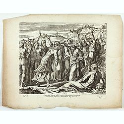
Sacerdos cornu olei unxit Salomonem omnisque clamauit. . . . ( Plate 45)
Fine etching by Nicolas Chapron, after Raphaël's (Raffaello Sanzio) frescoes in the Vatican Loggia. Scene illustrating a priest anointing Solomon with oil.From the first ...
Date: Paris, Petrus Mariette, 1649
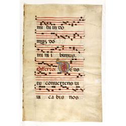
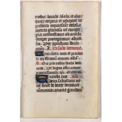
Leaf on vellum from an antiphonary.
A very fine antiphonary leaf, written in Latin , probably Rome. RECTO: A wonderful initial ,O, decorated with pen work in red, white and blue, in rich burnished gold.VERS...
Date: Italy, 1480

Map of China.
Showing China, Taiwan and Korea, divided into provinces with the main cities marked. The map is of interest for the use of Sea of Corea, the sea between Korea and Japan, ...
Date: London, 1804
![Tertia Etas Mundi. Folium. CI [Woodcut of Jesus and his apostles]](/uploads/cache/48519-250x250.jpg)
Tertia Etas Mundi. Folium. CI [Woodcut of Jesus and his apostles]
The Latin text page is illustrated with a depictions of Kings, Noble men and women and scientists. VERSO : A full page woodcut showing Jesus and his apostles.(360x221mm.)...
Date: Nuremberg, 12 July 1493
![[Title page] Le Theatre du Monde ou Nouvel Atlas.](/uploads/cache/06812-250x250.jpg)
[Title page] Le Theatre du Monde ou Nouvel Atlas.
Architectural frontage with the title and imprint printed on paste-on slips.Parts of the item are heightened in gold. Read more about maps heightened in gold
Date: Amsterdam, 1640
![Emouchoir des Otahitiens avec ses manches. [Tome II Pl. 13.]](/uploads/cache/26098-250x250.jpg)
Emouchoir des Otahitiens avec ses manches. [Tome II Pl. 13.]
The print depicts three ceremonial fly-whisks from Tahiti. Each object features ornate carved handles with anthropomorphic figures and long flowing fibers, accompanied by...
Date: Paris, 1773
![Timor. Rhinolophe Cruménifére. [plate XXXV]](/uploads/cache/46357-250x250.jpg)
Timor. Rhinolophe Cruménifére. [plate XXXV]
Plate illustrating Horseshoe bats from Timor Island, by Lesueur, from Voyage de découvertes aux terres Australes by François Péron, 1824.The French expedition under Nicol...
Date: Paris, 1824
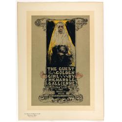
The quest of the golden girl . . .
Chromo lithographed poster, " The quest of the golden girl . . .", after Miss Ethel Reed (American, 1876–d. ca. 1925). Plate 128, published in Maître 32, on Jul...
Date: Paris, Imprimerie Chaix, April 1898

Nuova carta dell' Imperio della Chia e dei Paesi circonvicini. / Nueva carta de l'Impario de la Quina.
The map is of interest for the use of Mar di Corea" and "Mar Setentrionale del Giapone" in the sea between Korea and Japan.Rare early edition of Albrizzi's...
Date: Venice, 1740

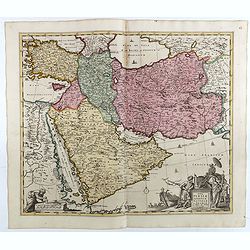
Nova Persiae Armeniae Natoliae et Arabiae.
This fine map shows the area East from Cyprus to Iran, including The Saudi Peninsula, Red Sea, Nile River, Cyprus, Asia Minor, the Gulf of Aden, the Indian Ocean, Armenia...
Date: Amsterdam, 1680
![[Title page] Voyage de découvertes aux terres Australes éxécuté par ordre de S.M l'Empereur et Roi.](/uploads/cache/39732-250x250.jpg)
[Title page] Voyage de découvertes aux terres Australes éxécuté par ordre de S.M l'Empereur et Roi.
Set of two title pages from the atlas part of "Voyage de decouvertes aux terres australes", Freycinet and Peron's accounts of the French cartographic expedition...
Date: Paris, Langois, 1811
![Manière dont on expose les morts à Otahiti. [Tome II Pl. 16.]](/uploads/cache/26113-250x250.jpg)
Manière dont on expose les morts à Otahiti. [Tome II Pl. 16.]
A view of a Tahitian funeral home in a beautiful landscape. Engraved by Demouchy. From the French edition of James Cook's first voyage entitled Relation des voyages entre...
Date: Paris, 1773
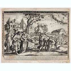
Afbeeldinghe vande: arck. met. Noe. en. het. vee. daer. bij.
Engraving by Jan van Londerseel (Antwerpen 1570 - Rotterdam 1624) and published by Claes Jansz. Visscher. Large engraving showing the ark of Noah. Noah, his three sons, t...
Date: Amsterdam, ca. 1650
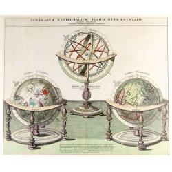
Sphaerarum Artificialium Typica Repraesentatio. . .
Stunning engraving of Homann's terrestrial and celestial globes and armillary sphere, all with highly ornamented stands. Brief explanatory text.Johann Baptist Homann born...
Date: Nuremberg, 1740
![Instruments des insulaires de la Mer du Sud. [Tome II Pl. 15.]](/uploads/cache/26097-250x250.jpg)
Instruments des insulaires de la Mer du Sud. [Tome II Pl. 15.]
Divers tools. From the French edition of James Cook's first voyage entitled Relation des voyages entrepris par ordre de sa Majesté Britannique actuellement régnante pour ...
Date: Paris, 1773

Viandox - Produit Liebig.
Lithographed advertising poster for a Viandox brand, printed in a bottle shape, by IMP. MAUSS, DEHALLE & URBAN - PARIS.
Date: Paris, between 1925 and 1930
![Matelot Hollandais [Dutch sailor]](/uploads/cache/28927-250x250.jpg)
Matelot Hollandais [Dutch sailor]
Etching showing a typical Dutch sailor, after Jacques Grasset de Saint-Sauveur (1757–1810). Taken from "Costumes Civils actuels de tous les peuples connus, dessinés ...
Date: Paris, Pavard, 1788
Borussiae Regnum compectens Circulos Sambiensem, Natangiensem, et Hockerlandiae Nee non Borussia Polonica, exhibens Palatinatus Culmiensem. . .
Decorative map covering northern Poland with Prussia, Pomerania, Hockerlandia, Warmiaermelandia, Natanglensis, Galindia, Nandrovia, Sclavonia, and the Baltic Sea. Include...
Date: Augsburg, 1759
![Timor. Naba-Leba Roi de L'Ile Solor. [plate XXV]](/uploads/cache/46347-250x250.jpg)
Timor. Naba-Leba Roi de L'Ile Solor. [plate XXV]
A portrait of a male Naba-Leba by Lesueur, from Voyage de découvertes aux terres Australes by François Péron, 1824.The French expedition under Nicolas Baudin, was commiss...
Date: Paris, 1824
Nova Persiae Armeniae Natoliae et Arabiae.
1725 DE WIT, F. / OTTENS, R. / J. - Shows the Saudi Peninsula and the area east of Cyprus to Iran.
Date: Amsterdam, 1725
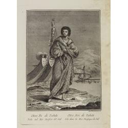
Otoo, Re di Tahiti Isola nel Mar Pacifico del Sud. / Otoo, Roi de Tahiti Isle dans la Mer Pacifique du Sud.
Full portrait of King Otoo from Tahiti. A rare engraving from "Raccolata di stampe ... di varie nazioni". From the original drawing by William Hodges, who accom...
Date: Venice, Antonio Zatta, c.1790
Leaf on vellum from a manuscript Book of Hours.
Leaf from a mid 15 th. century manuscript Book of Hours. Written on vellum in neat Gothic book hand.RECTO: 17 lines of text, with 2-line capital in red and blue, heighten...
Date: France ca.1470
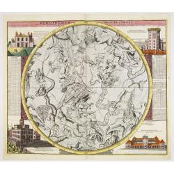
Hemisphaerium Coeli Australe in quo Fixarum. . .
Magnificent celestial chart drawn by the famous scientist Johann Gabriel Doppelmayr. Large circular charts of the southern hemisphere constellation, with decorative vigne...
Date: Nuremberg, 1747

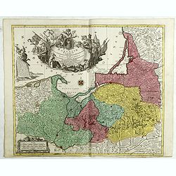
Hollandiae Antiquorum Catthorum..
This map shows Holland in great detail, including small towns, walled cities, rivers and lakes (many of which were reclaimed in the 17th century, and no longer exist). A ...
Date: Antwerp, 1598

Cary's New Terrestrial Globe Exhibiting The Tracks and Discoveries made by Captain Cook; Als...
An early Regency 21-inch terrestrial globe CARY, John and William. - Cary's New Terrestrial Globe Exhibiting The Tracks and Discoveries made by Captain Cook; Also those o...
Date: London, 1815/1818
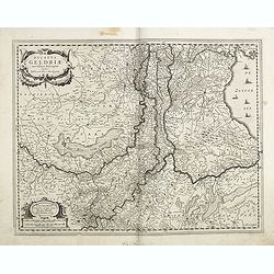
Ducatus Geldriae novissima. . .
Early map of Gelderland, but also including Utrecht, and parts of Brabant. Shows many cities (like Nijmegen, Eindhoven, Zutphen, Zwolle, etc), roads, rivers, woods, regio...
Date: Amsterdam, 1629-1630

Great or Asiatick Tartary, Agreable to Modern History.
Map of Tartary to Peking. The eastern coastline of Asia is almost flat, with no attempt to mark Kamchatka. The Caspian Sea in the lower left, with present-day Uzbekistan ...
Date: London, 1727
