Subscribe to be notified if similar examples become available.
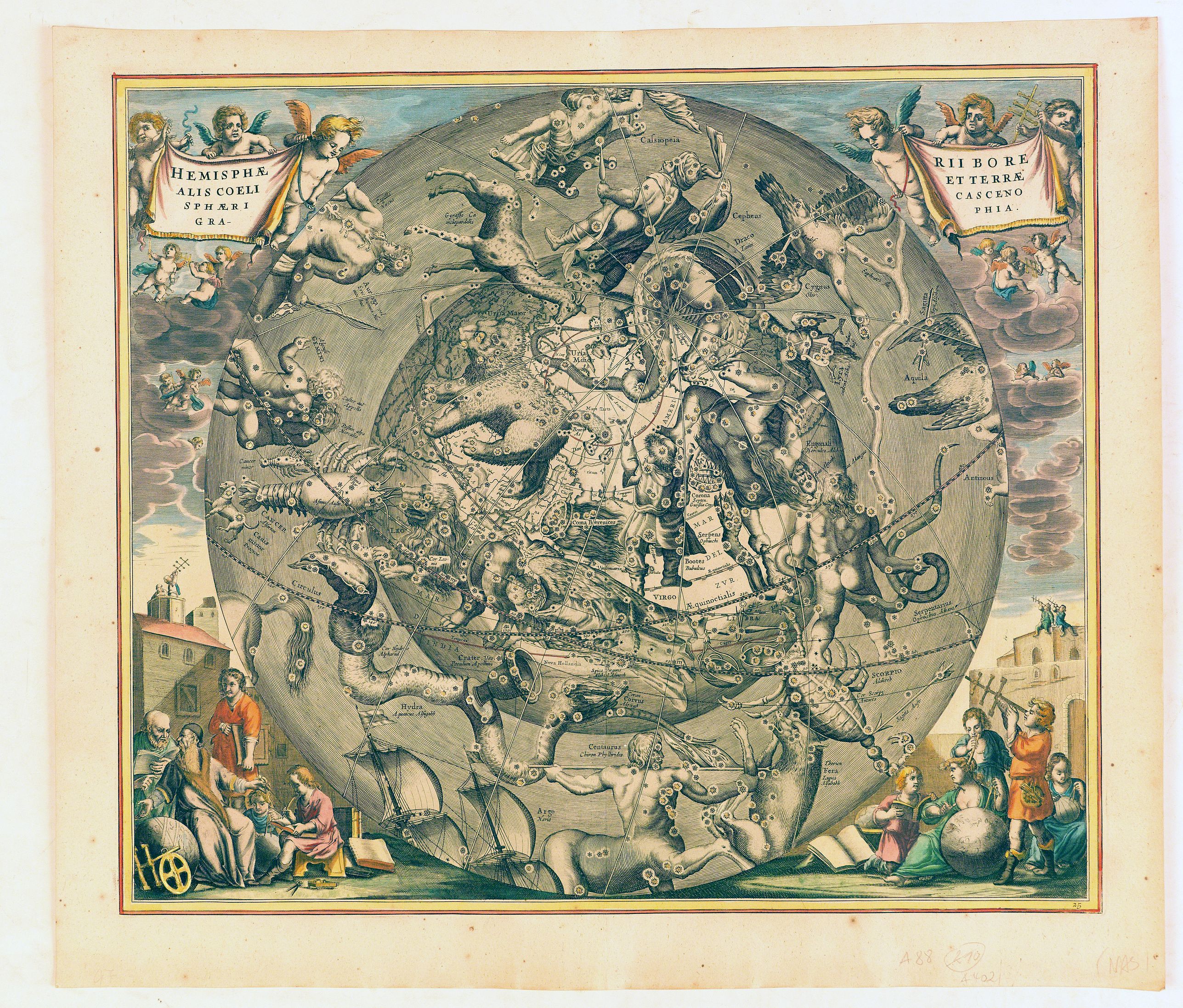
1661 CELLARIUS, A. - Hemisphaerii Borealis Coeli et Terrae Sphaeri Cascenographia.
Hemisphaerii Borealis Coeli et Terrae Sphaeri Cascenographia.
| Maker: | CELLARIUS, A. | |
| Date: | Amsterdam, 1661 | |
| Colored: | Colored. | |
| Size: | 420 x 490 mm / 16.5 x 19.3 inches | |
| Condition: | Clean image, heightened in gold, attractive colors.Dark impression. | |
You can choose from more than 30,000 items from our BuyNow Catalog or Archive.
It's free, and you can delete items from your to your Collection+ anytime.
 Add/Remove




Description
A finely executed celestial chart of the Northern Sky, illustrating the constellations of the Northern Hemisphere superimposed over the Pacific Ocean, first published by Andreas Cellarius in 1660.
The chart provides a fantastic image of the stars, as if seen from a deeper part of space, so that each of the constellations is facing in the opposite direction from the way they would be seen from Earth.
This projection reflects a theory that originated with Petrus Plancius, which posits that the stars remained in a sphere-like configuration above the Earth, moving in coordination with it. This theory is found in the title of his atlas, Harmonia Macrocosmica.
The celestial hemisphere is surrounded by an allegorical scene showing the most modern devices for astronomical observations in the lower corners
As noted by Kanas, the constellations are shown "in an external orientation between the north and south celestial poles . . . and the vernal equinox . . . .[based on] the work of Petrus Plancius.
Andreas Cellarius (active from 1656-1702), Dutch mathematician and geographer, rector of the Latin School at Hoorn. He may have been of German or Polish origin, with the name of Keller or Kellner.
Cellarius adopted the system of Julius Schiller who renamed all constellations known at that time and sketched them again in order to fit the sky into a system of Christian symbolism.
In Cellarius' Atlas Coelestis Schiller's system has been elaborated further. In fact, Schiller became more widely known by Cellarius' atlas than by his own work. Schenk and Valk re-published the book and added their names on the plate.
Andreas Cellarius (c.1596-1665)
Cellarius was a Dutch-German mathematician, astronomer and cosmographer, born about 1596 in Neuhausen (near Worms), who died in 1665. He was educated at the University of Heidelberg and emigrated to Holland in the early 17th century. In 1637 he moved to Hoorn, where he became rector (headmaster) of the Latin School, and there he wrote the Harmonia Macrocosmica and his other scholarly works, including one on designing impregnable fortifications and one on Poland. Little is known of his life, and until recently almost nothing. In 2008 the minor planet 12618 Cellarius was named after him.He is well known for his Harmonia Macrocosmica seu Atlas Universalis et Novus, Totius Universi Creati Cosmographiam Generalem, et Novam Exhibens.
Cellarius began work on the charts in 1647, as a historical introduction to a two-volume treatise on cosmography. Only this first part was ever realized. It was published in 1660 (and 1661) by the Amsterdam publisher Johannes Janssonius (1588–1664) as a cosmographical supplement to his Atlas Novus.
The atlas has 29 double-folio engravings, a compendium of theories of the universe as of the late 17th century. It shows the old geocentric universe of Ptolemy, the heliocentric system of Copernicus, and Tycho Brahe’s hybrid, as well as the motions of the planets, the constellations of the northern and southern skies, and the phases of the Moon. The margins are decorated in the Baroque manner with cherubs, astronomers and classically dressed women holding scientific instruments among the clouds. It is the only celestial atlas published in the Netherlands in the golden age of Dutch cartography.
The atlas was leter republished by Schenk and Valk.
FAQ - Guarantee - Shipping
This item is available for immediate purchase when a "Add to Cart" or "Inquire Now" button is shown.
Items are sold in the EU margin scheme
Payments are accepted in Euros or US Dollars.
Authenticity Guarantee
 We provide professional descriptions, condition report (based on 45 years experience in the map business)
Paulus Swaen warrants the authenticity of our items and a certificate of authenticity is provided for each acquired lot.
Condition and Coloring
We indicate the condition of each item and use our unnique HiBCoR grading system in which four key items determine a map's value: Historical Importance, Beauty, Condition/Coloring and Rarity.
Color Key
We offer many maps in their original black and white condition. We do not systematically color-up maps to make them more sellable to the general public or buyer.
Copper engraved or wood block maps are always hand colored. Maps were initially colored for aesthetic reasons and to improve readability. Nowadays, it is becoming a challenge to find maps in their original colors and are therefor more valuable.
We use the following color keys in our catalog:
Original colors; mean that the colors have been applied around the time the map was issued.
Original o/l colors; means the map has only the borders colored at the time of publication.
Colored; If the colors are applied recently or at the end of the 20th century.
Read more about coloring of maps [+]
Shipping fee
A flat shipping fee of $ 30 is added to each shipment by DHL within Europe and North America. This covers : International Priority shipping, Packing and Insurance (up to the invoice amount).
Shipments to Asia are $ 40 and rest of the world $50
We charge only one shipping fee when you have been successful on multiple items or when you want to combine gallery and auction purchases.
Read more about invoicing and shipping
FAQ
Please have a look for more information about buying in the BuyNow gallery
Many answers are likely to find in the general help section.
My Collection+

With My Collection+ you can collect all your favorite items in one place. It is free, and anyone can create his or her virtual collection.
Unless you are logged in, the item is only saved for this session. You have to be registed and logged-in if you want to save this item permanently to My Collection+. Read More[+]
Register here, it is free and you do not need a credit card.
Add this item to My Collection+ or click the following link to see My Collection+.
|
Digital Image Download Paulus Swaen maintains an archive of most of our high-resolution rare maps, prints, posters and medieval manuscript scans. We make them freely available for download and study. Read more about free image download |
Click the image for a free small image download. |
YOUR RIGHT TO CANCEL THE PURCHASE OF A LOT
In accordance with the EU Consumer Rights Directive and habitually reside in the European Union you have the right to cancel the contract for the purchase of a lot, without giving any reason.
The cancellation period will expire 14 calendar days from the day after the date on which you or a third party (other than the carrier and indicated by you) acquires, physical possession of the lot. To exercise the right to cancel you must inform Paulus Swaen Inc, of your decision to cancel this contract by a clear statement (e.g. a letter sent by post, or e-mail.
To meet the cancellation deadline, it is sufficient for you to send your communication concerning your exercise of the right to cancel before the cancellation period has expired.
