Popular Listings
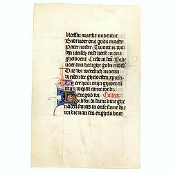
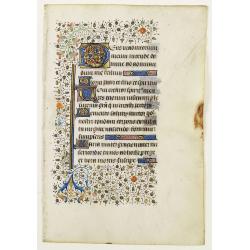
Manuscript leaf on vellum from a Dutch Book of Hours.
VERSO: Two 2-line capitals in burnished gold with extensive penwork in blue and red. Two 1-line capitals in red, blue or burnished gold with extensive penwork.RECTP: One ...
Date: Utrecht, c.1400-1410

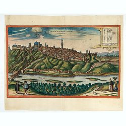
Vue de la ville et du château de Heidelberg . . . Ansicht der stadt und des schlosses Heidelberger . . .
Engraving after Louis Charles François de Graimberg-Belleau. Engraved by Ch. Haldennvang.French artist. Son of Gilles-François Belleau Graimberg. Louis Charles François e...
Date: Graimberg, Heidelberg, ca. 1840

Guaranty Trust Company of New York. Emprunt national 6%.n Souscrivez.
Very decorative propaganda poster with design by Mark All of Paris for "Guaranty Trust Company of New York", a JPMorgan Chase predecessor in order to promote th...
Date: Paris, 1918
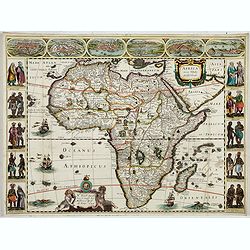
Africa nova Tabula.
Very rare map of Africa separately published. This derivative map by Nicolas Picart is based upon the second state of Janssonius' map of 1623, after the lower border had ...
Date: Paris, 1644
Selling price: ????
Please login to see price!
Sold in 2023

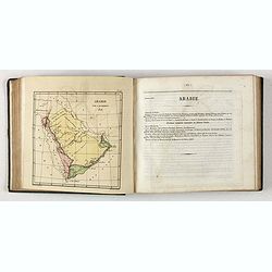
Carte de l'Arabie d'après les différents morceaux qu'a donnés M. Niebuh...
Detailed map of the Arabian Peninsula, after Niebuhr, with scales in the lower left corner. Engraved by Pierre-Paul Dubuisson.More about Mapping of Arabia [+]
Date: Paris, ca. 1820
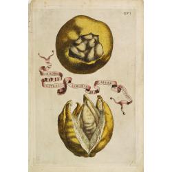
Aliae Formae Citrati Limonis Alios Includentis.
Decorative engraving representing a citrus fruit. Taken from the book "Hesperides sive de malorum aureorum" by Giovan Battista Ferrari (Italian botanist, 1584-1...
Date: Rome, Scheus, 1646

Vue perspective de la grande Ceremonie du Couronnement de l'Empereur de la Chine.
So-called optical print illustrating the crowning of the Chinese emperor. It shows the throne at the center.Mondhare was a well-known publisher of optical prints, establi...
Date: Paris, 1761

Avantures du Sr. C. Le Beau, avocat en parlement ou Voyage curieux et nouveau parmi les Sauvages de l'Amérique Septentrionale. Dans lequel on trouvera une Description du Canada… Ouvrage enrichi d'une Carte et des figures necessaires.
A description of Huron, Iroquois, and Algonquin customs, written in charming style and based, the Author claims, on observations made on a trip to America in 1729." ...
Date: Amsterdam, 1738
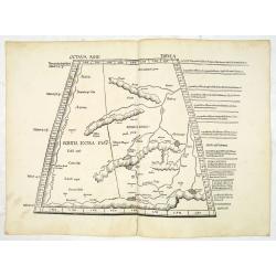
Octava Asie Tabula.
PTOLEMY, C. / WALDSEEMÜLLER, M. - The Silk Road Area.
Date: Strasburg, 1513

Kaartje van Asia. . .
Attractive and rare map of Asia. From Atlas Portatif . With a curious and oversized Hokkaido. The map is of interest for the use of Coreanse Zee for the sea between Korea...
Date: Deventer 1742
![Pisces in mari alati [flying fish attack]](/uploads/cache/48527-250x250.jpg)
Pisces in mari alati [flying fish attack]
Flying fish attacking a Portuguese ship in the West Indian Waters.Read more about "Les Grand Voyages" by Theodore De Bry [+]
Date: Frankfurt, 1594
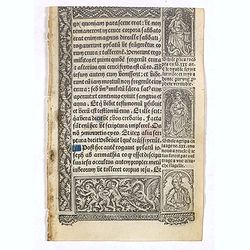
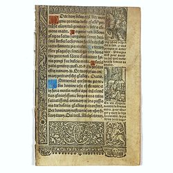
Leaf on vellum from a printed Book of Hours.
21 lines of printed text, surrounded by Renaissance borders decorated with flowers, vases and persons in Medieval dress.From the press of the leading Parisian publisher a...
Date: Paris, Germain Hardouyn, c. 1520-1540

Bison Iubatus.
Etching of a bison by Leendert Brasser (1727 - 1793) after a painting of the Dutch artist Gerrit van den Heuvel.An early portrait of a bison, etched by Leendert Brasser (...
Date: Rotterdam, 1766-1793

London in Miniature With The Surrounding Villages. An Entire New Plan In which the Improvements both present and intended are actually reduced, by permission, from the surveys of the Several Proprietors. . .
Hand-coloured engraved map, dissected and mounted on linen, orange publishers label on one side, extending west to east from Kensington to East India and Greenwich Dock a...
Date: London, 1821
Leaf on vellum from a manuscript Book of Hours.
RECTO: Panel border of acanthus leaves and flowers on a partly liquid gold and dark red ground, height 1-line initial in liquid gold on colored grounds and three line fil...
Date: France, ca. 1420-1480

Straat Sunda en Westkust van Java.
Very large and rare chart depicting Java's western seacoast close to the Sunda Strait.Showing part of Sumatra on top and the West Java tip, today hosting the Ujung Kulon ...
Date: Amsterdam (1841)1846

Nieuwe kaart van het oostelykste deel van Holland. . .
Detailed map covering the area of Gouda, IJsselstein, s'Hertogenbosch, Zevenbergen, Dordrecht.
Date: Amsterdam, 1749
![Uomo dell' Isola di Tanna, una delle nuove Ebridi nel Mar Pacifico. / Homme de l' Isle de Tanna, une des nouvelles Hébrides dans la Mer du Pacifique. [Vanuatu]](/uploads/cache/26399-250x250.jpg)
Uomo dell' Isola di Tanna, una delle nuove Ebridi nel Mar Pacifico. / Homme de l' Isle de Tanna, une des nouvelles Hébrides dans la Mer du Pacifique. [Vanuatu]
Full portrait of a man from the island of Tanna in the Pacific. New Hebrides, officially the New Hebrides Condominium was the colonial name for the island group in the So...
Date: Venice, Antonio Zatta, c.1790
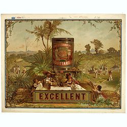
Café des gourmands E. Guittard - Excellent.
Original chromo lithographed coffee advertising poster by Gonthier-Dreyfus & Co., for E. Guittard & Co. The company was started by Eddy Guittard, who emigrated fr...
Date: Paris, ca. 1880
Selling price: ????
Please login to see price!
Sold in 2023
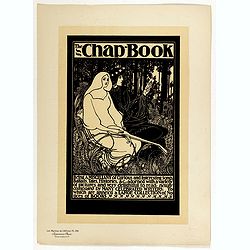
The Chap Book.
Chromo lithographed poster, "The Chap Book.", by BRADLEY, W. Plate 136, published in Maître 17, on April 1895. The "Les Maîtres de l'Affiche" containe...
Date: Paris, Imprimerie Chaix, April 1895
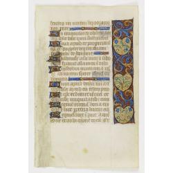
Manuscript leaf with 2-line illuminated capital L.
Fine leaf from a Book of Hours, Psalm 148 Veni Creator Spiritus, mentes tuorum visita imple superna gratia quae tu creasti pectora .. RECTO: One 3-line illuminated capita...
Date: Brugge, ca 1460
Bronwater of geneesmiddel voor de zieke actionisten.
Springwater or potion for the sick shareholder, taken from Het groote tafereel der dwaasheid : vertoonende de opkomst, voortgang en ondergang der actie, bubbel en windneg...
Date: Amsterdam, 1720

Geometria, from The Seven Liberal Arts.
A female figure with a castle on her head measures a globe with a compass; representing geometry. Engraving by Johann Sadeler I after M. de Vos.
Date: Antwerp, 1570 - 1600

Das Hertzogthum Braband. . .
Charming map of the Dutch and Belgium province of Brabant. With a fine cartouche.
Date: Leipzig, 1749
Bibliomappe. Chronologie Historique et Géographique par MM. Année et Vivien bound with : Bibliomappe, ou Livre-Cartes: Leçons Méthodiques de Chronologie et de Géographie, . . .
With 67 maps (1 folding) by A.M. Perrot. Published in Paris. Most maps have original color. The atlas is complete very rare, as it was issued in 15 separate installments ...
Date: Paris, Renard, 1827 / 1824-1826
Leaf on vellum from a printed Book of Hours.
21 lines of printed text, surrounded by Renaissance borders decorated with flowers and little miniatures with figures on both sides.From the press of the leading Parisian...
Date: Paris, Germain Hardouyn, c. 1520-1540

Forest scene on the Tobihanna Alleghany Mountains.
Original aquatint engraving for Travels in the Interior of North America between 1832-34 . Engraved by L.Weber. The finest work on American Indian life and the American F...
Date: London/Paris/Coblenz, 1839

.Paskaarte om Achter Yrlandt om te Zeylen van Hitlant tot. . .
An eye-catching chart of Ireland, including the north of England and Scotland, with the West to the top.Pieter Goos (ca. 1616-1675) was one of the most important cartogra...
Date: Amsterdam, 1673
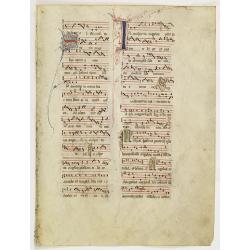
Leaf on vellum from an antiphonary.
A more than 600 years old antiphonary leaf, written in Besançon, in 1370. Musical notation on 4 bars, the staves are in red and the notes in black: numerous pen-flourishe...
Date: France, Besançon, 1370
![[Manuscript] Plan du siege de la forteresse d'Oczakow avec les détails... aux ordres du Prince Potemkin, le 17 Decemb: 1788.](/uploads/cache/34599-250x250.jpg)
[Manuscript] Plan du siege de la forteresse d'Oczakow avec les détails... aux ordres du Prince Potemkin, le 17 Decemb: 1788.
Very detailed well executed manuscript plan of the Turkish Fortress Ochakov captured by Russian Troops on December 17, 1788 by the Maréchal Prince Potemkin. In lower left...
Date: ca. 1788

Carte Geographique, Statistique et Historique de Buenos-Ayres.
A nice detailed map of what is today northern Argentina (Rep. of Buenos Ayres or the United Provinces of South America) from Buchon's Atlas Gégraphique Statistique, histo...
Date: Paris, 1825

Israel.
Decorative poster advertising flights to Israel made by Georges Mathieu. The poster is one of a series of 15 posters of Greece, Israel, Germany, Great Britain, Canada, Eg...
Date: Paris, 1967
![View in the island of Cracatoa. [Rakata in the Sunda Strait]](/uploads/cache/30051-250x250.jpg)
View in the island of Cracatoa. [Rakata in the Sunda Strait]
Early view of the volcano Krakatoa (Indonesian name: Krakatau), on the Indonesian island of Rakata in the Sunda Strait, taken from "Views in the South Seas" bei...
Date: London, Boydell and Co., 1808
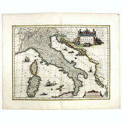
Nova Italiae delineatio.
Originally engraved for Jodocus Hondius II, at his death in August 1629 this map was, among other copper plates,purchased by Willem Blaeu who trimmed the figured borders,...
Date: Amsterdam, 1638
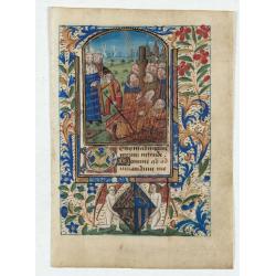
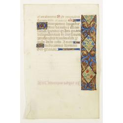
Miniature of Suffrages to the Saints.
A fantastic miniature (70 x 50 mm.) in an arched compartment showing the Suffrages to the Saints. Depiction of the (50) martyrs being burnt before the King's orders. The ...
Date: France, Bretagne or Normandy, c. 1480
Selling price: ????
Please login to see price!
Sold in 2024
Historic Map - Naaukeurige Kaart Van Tartaryen, Soo als dat door W De Rubruquis doorreyst.
This attractive map published by Pieter van der Aa, shows Tartary abd the ancient Silk Road region. The map shows the track of William of Rubruck (Willem van Rubroeck or ...
Date: Amsterdam, 1713-1729

Carta particolare che comincia con il c.apo Aldea è Finisce con il capo Degortam. . .
Dudley’s magnificent chart shows the south west coast of Africa with the Tropic of Capricorn, located at about 23.5 degrees south. Without the privilege, but with "L...
Date: Florence, 1645
![Grote Atlas van de Verenigde Oost-Indische [Complete set of 7 volumes] Compagnie/Comprehensive Atlas of the Dutch United East India Company](/uploads/cache/49206-250x250.jpg)
Grote Atlas van de Verenigde Oost-Indische [Complete set of 7 volumes] Compagnie/Comprehensive Atlas of the Dutch United East India Company
This seven volume atlas was published in a limited edition. It covers all territories and possessions under the Charter of the Dutch East India Company (VOC) from 1602-17...
Date: Voorburg, Asia Maior/Atlas Maior, 2006-2010
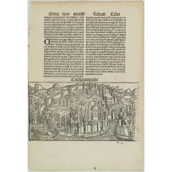
Constatinopolis.
Panoramic town-view of Constantinople (Istanbul). Woodcut published in the so-called pirate edition of the "small Schedel" in Augsburg, 1497, Latin edition. Ori...
Date: Augsburg, Johann Schönsperger. 1497

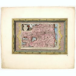
Hollandiae pars septentrionalis, Vulgo Westvriesland..
Based on the work of B.F.van Berckenrode, this fine map, orientated west to the top of the sheet, includes Kennemerland and Hollands Noorderkwartier and is a reasonably u...
Date: Amsterdam, ca. 1667

Mariner’s compass
Inverted compass called "snitch" in wood painted in imitation of tortoiseshell and brass, signed "Ing MANN Maker Water Street Liverpool".
Date: Liverpool, ca. 1785

Oost-Indis Zee Magazyn - Arçenal des Indes Orientalis.
Decorative view of the East Indian Arsenal, now-a-says the Maritime Museum.
Date: Amsterdam, ca. 1700

Leaf on vellum from an antiphonary.
A very fine antiphonary leaf, written in Latin, probably Rome. RECTO: The staves are in red and the notes are in black.VERSO: The staves are in red and the notes are in b...
Date: Italy, 1480
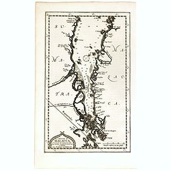
Le détroit de Malacca . . .
Map of Malacca. The map details the Strait of Malacca from P. Peru and Tanjong Goeree to Lingen and Pulu Panjang. Malacca and Ihor (Johore), along with numerous other coa...
Date: Leiden, 1712
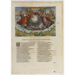
Americae Retectio (Allegory of the Discovery of America)
Allegorical scene commemorating the discovery of America. The main image shows Neptune, supporting a Globe, flanked by Flora-representing Florence, and Janus-representin...
Date: Frankfurt, 1594
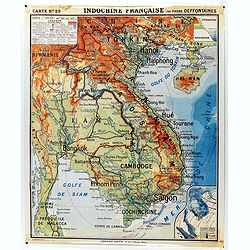
Indochine française. Carte N° 29.
School map of Indochina by Pierre Deffontaines Agréée d'Histoire et de Géographie Docteur es Lettres, published c. 1940 by "Librairie Hatier". Scale : 1:1 600 0...
Date: Paris, c. 1940

Korte geographische oefeningen voor het eerste onderwijs in de kennis der geheele aarde
Ilustrated with World Map, map of Europe, the Netherlands, Asia, Africa, North America, South America and Australia.Provenance : J.de Veth, October 1845.
Date: Zaltbommel, 1843

A new mape of Ye XVII Provinces of Low Germanie.
Showing all 17 Provinces of the Netherlands before the split between Spain and the Protestant Provinces under the House of Orange. The map was published while the war of ...
Date: London, George Humble, 1626 [1627

Fokien Imperii Sinarum Provincia undecima.
The province of Fokien lies opposite Taiwan and south of the region described in the above map. The coast is shown from Wen-zhou in the north to Fu-zhou and as far south ...
Date: Amsterdam, 1660

Save means to increase.
Uncommon Soviet propaganda poster published during the early years of the Perestroika & Glasnost period (1985 - 1991) by Plakat (All-Union Poster), Moscow — Плака...
Date: Moscow, 1986
Selling price: ????
Please login to see price!
Sold in 2024
![Plan de la partie sud des Iles Furneaux [with] Carte générale de la Partie Sud-Est de la Terre de Diémen . . .](/uploads/cache/46365-250x250.jpg)
Plan de la partie sud des Iles Furneaux [with] Carte générale de la Partie Sud-Est de la Terre de Diémen . . .
Two maps on one sheet, on top a map of the southern portion of Cape Barren Island, Clarke Island, and islets in the southern part of the Furneaux Group.With in lower part...
Date: Paris, 1824

La China e Giapone.
Uncommon map of China, Korea, Japan and Taiwan (I.Formosa), only one town labeled, Tayoan. Very strange shape for Japan.The map is of interest for the use of Mar di Corea...
Date: Italy, ca. 1800
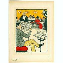
Recklame Plankater . . .
Chromo lithographed poster of Les Maîtres de l'Affiche being plate n°84. The "Les Maîtres de l'Affiche" contained 256 small for lithographic prints of the best ...
Date: Paris, Imprimerie Chaix, 1897

De Texel Stroom .. vant Marsdiep./ Caarte van De Mase...
Two decorative charts on one sheet, one depicting Texel and the entrance of the Zuider Zee with an inset showing the north coast of West-Friesland, the other depicting th...
Date: Amsterdam, 1660
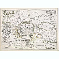
Romani Imperii Oriens est Descriptio Geographica. . .
A fine map of the Near East. The map was first published by Tavernier and later by Mariette. This edition is dated 1637 with the address of Pierre Mariette at rue S. Jacq...
Date: Paris, after 1637
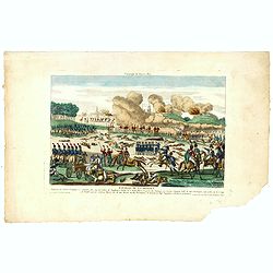
Bataille de la Moskwa Remportée par l'Armée Française le 7 Septembre 1812...
Uncommon print showing the siege of Moscow on September 7, 1812 by Napoleon Bonaparte.Jean was a well-known publisher of optical prints and other popular prints, establis...
Date: Paris, ca. 1815
![[Europe depicted as a Queen]](/uploads/cache/41499-250x250.jpg)
[Europe depicted as a Queen]
Among the most striking of early cartographic curiosities is Europe regina or Queen of the world first published by Johannes Bucius' and populized by Sebastian Münster.. ...
Date: France, ca. 1860

Nieuwe Wassende Graade Zee Kaart over de Spaanse Zee Vant Kanaal tot 't Eyland Cuba In Westindia.
Rare two-sheet blue-back sea chart of the Atlantic and Eastern part of North America., published by Gerard Van Keulen. The map extends from the latitude of Newfoundland a...
Date: Amsterdam, ca. 1728-1751

Plan du Port du Sud de la Baie de la Recherche / Croquis de la Baie des Moules. . .
A French maritime chart of the Port du Sud in Research Bay and the mouth of the Bay of Mussels, both in southern Tasmania. This is the edition of the extremely rare atlas...
Date: Paris, ca 1807

ETATS-UNIS DE L'AMÉRIQUE SEPTENTRIONALE Avec LES ISLES ROYALE, DE TERRE NEUVE, DE S.T JEAN, L'ACADIE, &c. 1785. Supplement a l'Atlas de M. Robert de Vaugondy a Paris Ches Boudet Ingenieur du Roi.
A map of the eastern United States with "Supplément à l'atlas de M. Robert de Vaugondy à Paris chez Boudet Imprimeur du Roi", in place of the attribution to Del...
Date: Paris, 1785

(Art déco gouache)
Outstanding "art deco" gouache (unsigned) from the workshop of "Robert Pichon. Ateliers de Dessin et Lithographie – 10, rue Rochechouart – Paris. The goua...
Date: Paris, ca. 1930
Leaf on vellum from a manuscript Book of Hours.
RECTO: Panel border of acanthus leaves and flowers on a partly liquid gold and dark red ground, one 2-line initial and one 1-line initial in liquid gold on colored ground...
Date: France, c.1450

Siberia & Central Asia.
This map covers the eastern section of Russia as well as China, Japan, Korea, India and Tibet. The map is of interest for the use of Sea of Corea, the sea between Korea a...
Date: Boston, 1835
Znaymum vulgo Znaym, Moraviae Civitas Primaria.
Rare bird's-eye view of Znojmo (Znaim). A key to 12 locations.COMMENTARY BY BRAUN: "This is a beautiful and wealthy city in Moravia, situated on the border to Austri...
Date: Cologne, 1618
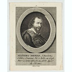
M.Merian, l'Ancien célébre graveur . . .
Portrait of Matthäus Merian (1593-1650) by Hubert. Matthäus Merian der Ältere was a Swiss-born engraver who worked in Frankfurt for most of his career, where he also ran...
Date: Paris, 1784

America settentrionale. . .
Rare map of North America drawn directly from the work of Nicholas De Fer and N. Sanson's famous map of 1650. The map is engraved by Antonius Donzel Gallus.With open Grea...
Date: Napels, 1766
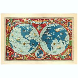
AIR France - Sur les ailes d'Air France découvrez le monde à votre tour.
Promotional poster of a double hemisphere world map designed by Lucien Boucher for AIR France. The map depicts the entire world in rich blues and burgundies with gold hig...
Date: Perceval, Paris, 1952

A Hysterical Map of the Yellowstone Park. . .
A funny 1936 pictorial map of Yellowstone Park, that was 'hatched and scratched' by the American printer and humourist Jolly Elmer Lindgren. This wonderful map covers the...
Date: Spokane, 1936

Perspective print by Vredeman de Vries. 12
Engraving from Perspective, c'est a dire, le tresrenomme art du poinct oculaire d'une veue dedans ou travers regardante, estant sur une muraille unie, sur un tableau, ou ...
Date: The Hague, 1604 - 1605
![Otago Capo dell'Isola d'Amsterdam nel Mare Pacifico del Sud. / Otago Chef de l'Isle d'Amsterdam dans la Mer Pacifique du Sud. .. [Tongatapu, Tonga]](/uploads/cache/26090-250x250.jpg)
Otago Capo dell'Isola d'Amsterdam nel Mare Pacifico del Sud. / Otago Chef de l'Isle d'Amsterdam dans la Mer Pacifique du Sud. .. [Tongatapu, Tonga]
Otago was a native of the island of Tongatapu, Tonga. The island was first sighted by Europeans in 1643 by Abel Tasman, commanding two ships. “Tasman named the island &qu...
Date: Venice, Antonio Zatta, c.1790
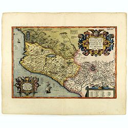
Hispaniae novae sive magnae recens et vera descriptio. 1579
This was the standard map of the area for a generation, copied by De Bry, Quad and Hondius. Even though Herrera (Spain's Royal Cosmographer) and Wytfliet worked 20 years ...
Date: Antwerp, 1598
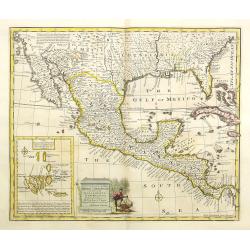
A new and accurate map of Mexico or New Spain with California New Mexico . . .
With inset of Galapagos islands. A wonderfully engraved map showing the entire American South from Carolina to California, as well as all of Mexico and Central America. A...
Date: London, 1747
![[Queen Obera welcoming Captain Wallis. Tahiti ].](/uploads/cache/26381-250x250.jpg)
[Queen Obera welcoming Captain Wallis. Tahiti ].
Aquatint depicting Queen Obera welcoming Captain Wallis upon his arrival in Tahiti. Engraved by Gallina. Plate N° 82. From Giulio Ferrario's work Le Costume Ancien et Mod...
Date: Milan, 1827
Islands in the Atlantic.
Decorative steel engraved map of Islands showing the Azores, Madeira, Bermuda, the Canaries and the Cape Verdes. Interlocking border design. Taken from "The illustra...
Date: London, ca. 1851
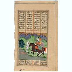
Persian miniature paintings, Mogul Dynasty.
Indo/Persian, Mogul Dynasty miniature painting in delicate Opaque watercolors on paper, with Islamic scripts on recto and verso. Miniature about 135 x 150mm. Painted in g...
Date: Northern Indian Mogul dynasty, ca 1800-1850

Mapa Polski i Krajów Osciennych - Wydanie trzecie. Opracowal Stanislaw Max. Wydani M. Arcta.
‘The Birth of Modern Poland on a map’ - an excellent wall map of Poland and surrounding regions, published in Warsaw near the end of World War I, when Poland’s fate was u...
Date: Warsaw, [H. Sklodowski], 1918
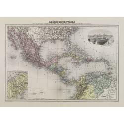
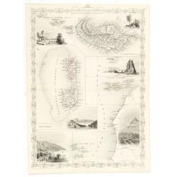
Amérique Centrale.
Decorative map of Central America from Géographie Universelle, Atlas Migeon. With an inset map of the Isthmus of Panama lower left corner and a panoramic view of Mexico C...
Date: Paris, 1874
![Nouvelle-Hollande: Terre dEndracht - Cabane des naturels de la Presqu'Ile de Péron. [plate XXIV]](/uploads/cache/46346-250x250.jpg)
Nouvelle-Hollande: Terre dEndracht - Cabane des naturels de la Presqu'Ile de Péron. [plate XXIV]
An aboriginal camp fire, after the original sketches by Lesueur, from Voyage de découvertes aux terres Australes by François Péron, 1824.The French expedition under Nicol...
Date: Paris, 1824
![[Sea monsters] De regni Settentrionali Monstri marini & terrestri…](/uploads/cache/49169-250x250.jpg)
[Sea monsters] De regni Settentrionali Monstri marini & terrestri…
Münster's plate of monsters of both land and sea, taken from an Italian text edition of Münster's Cosmographia, which is a short and complete summary of Renaissance knowl...
Date: Basel, 1558
![[Papua New Guinea Inhabitants ].](/uploads/cache/26364-250x250.jpg)
[Papua New Guinea Inhabitants ].
Aquatint depicts three men in a pirogue engraved by Fumagalli. Plate N° 75. From Giulio Ferrario's work Le Costume Ancien et Moderne ou Histoire du gouvernement, de la mi...
Date: Milan, 1827
