Browse Listings

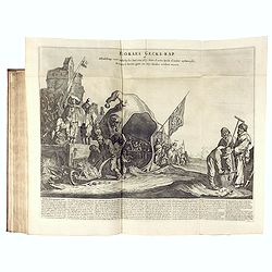
Le Nouveau miroir des voiages marins de la navigation de la mer occidentale & orientale.
A second and final French edition of this important sea atlas. Two engraved frontispieces, figure with volvelle, full-page figure, 48 double-page charts (one numbered 19....
- $120000 / ≈ €112286
Place & Date: Antwerp, Chez Iean Bellere, a l’Aigle d’or, l’An M.CCCCCC (1600

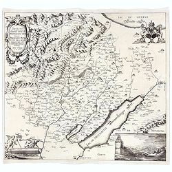
French composite atlas made up of rare maps published by Parisian editors from the 17th century , mainly by G. Jollain including scarce maps of America.
A rare French composite atlas including 90 maps, published by Parisian publishers from the 17th century, mainly by Gérard I Jollain, or by maps bought from Dutch publish...
Place & Date: Paris, ca. 1675
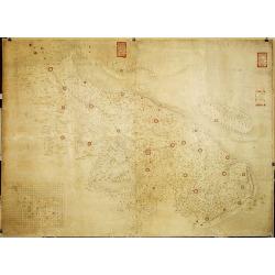
Militairy manuscript map of the end of Yangzi River across Shanghai, Jiangsu, and Zhejiang areas, with 3 red seals of the Ever-Victorious Army.
In lower left corner an inset plan of Songjiang District with Shanghai with a grid and the area is divided with red doted border lines.The map has three red seals of the ...
Place & Date: China, ca 1862
![[A magnificent 18 inch. (46 cm.) diameter celestial globe] URANOGRAPHIA / SYDERUM ET STELLARUM / in Singulis Syderibus conspicuarum / exhibens Delineationem accuratissimam, / qua / ex Observationibus Astronomi plane Singularis / IOHANIS HEVELII...](/uploads/cache/48959-250x250.jpg)
[A magnificent 18 inch. (46 cm.) diameter celestial globe] URANOGRAPHIA / SYDERUM ET STELLARUM / in Singulis Syderibus conspicuarum / exhibens Delineationem accuratissimam, / qua / ex Observationibus Astronomi plane Singularis / IOHANIS HEVELII...
RARE FIRST STATE OF THIS CELESTIAL TABLE GLOBE, 46 cm in diameter, produced by Gerard and Leonard Valk at the beginning of the 18th century. The globe comprises of t...
- $95000 / ≈ €88893
Place & Date: Amsterdam, 1711
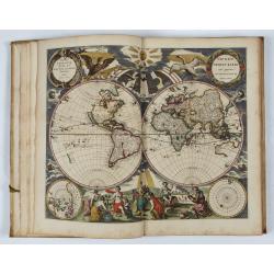
L’Atlas de la Mer ou Monde aquaticque.
Original blind-stamped vellum binding ; attractive ORIGINAL HAND-COLOR in outline with cartouches, windroses and decoration in full orginal color ; internally some usual ...
- $75000 / ≈ €70179
Place & Date: Amsterdam, sur le Cay de Teexel, prez du Rams-Koy, au miroir de la Mer, 1670
Atlas van Zeevaert en Koophandel door de Geheele Weereldt.
Engraved frontispiece, title printed in red and black with engraved vignette, engraved dedication to the Dutch East India Company, 32 double-page engraved charts with con...
- $65000 / ≈ €60822
Place & Date: Amsterdam, 1745
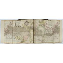
J.Horsburgh/ R.H.Bate / G.H.Stapleton. The two chart books are bound in contemp. half calf, and include together 57 of the most up-to-date French (Depot général de la marine) and English (Hydrographic Office) charts available in 1847 for sailing t
BOOK 1 : Mainly charts by "Dépôt Général de la Marine" including 20 folding charts. The binding measuring 665x275mm, the charts mostly 595x910mm.1. Dépôt ...
- $50000 / ≈ €46786
Place & Date: Paris, London, Hong Kong, 1835 - 1849
Atlas van Zeevaert en Koophandel door de Geheele Weereldt.
Engraved frontispiece, title printed in red and black with engraved vignette, engraved dedication to the Dutch East India Company, 32 double-page engraved charts in very ...
- $50000 / ≈ €46786
Place & Date: Amsterdam, 1745
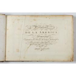
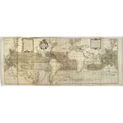
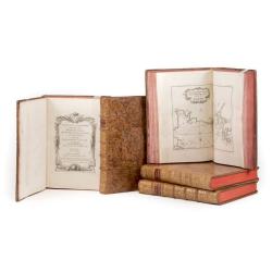
Portulano de la Ameririca Setentrional construido en la direccion de tabajos.
The Portulano de la America Setentrional, is an exceedingly rare Spanish sea atlas featuring charts of the Caribbean and the Gulf of Mexico. It was developed by the astr...
- $45000 / ≈ €42107
Place & Date: Madrid, 1818

Connecticut and Parts adjacent at Amsterdam. .
A nice example of this early map of the state of Connecticut with part of Rhode Island to the east, Long Island to the south, and New York to the east. Rivers, roads, t...
- $30000 / ≈ €28072
Place & Date: Amsterdam, 1780
Le Petit atlas maritime. Recueil de cartes et plans des quatre parties du monde, en cinq volumes.
FIRST EDITION. A large paper copy, in attrictive original colors. Jacques Nicolas Bellin held offical status as royal hydrographer and ingéniuer géographe de la marine ...
- $45000 / ≈ €42107
Place & Date: Paris, 1764
Le Nouveau Theatre du Monde, ou la Geographie Royale composée de nouvelles cartes tres-exactes..
Pieter van der Aa (1659 1733) was a prolific late seventeenth and early eighteenth-century publisher. His output was not just restricted to atlases: he also produced topo...
Place & Date: Amsterdam, 1720
![Shintei Bankoku Zenzu [Revised Comprehensive Map of All Countries]](/uploads/cache/48437-250x250.jpg)
Shintei Bankoku Zenzu [Revised Comprehensive Map of All Countries]
Compiled by Kageyasu Takahashi, the finest world map of the Edo period, copper plate print, 1810. Bunka 7 is dated from the preface on this map,This world map, published ...
- $26000 / ≈ €24329
Place & Date: Kyoto, Bunka 7 or 1810
![DE WIT, Frederick. [Zee Atlas].](/uploads/cache/48904B-250x250.jpg)
DE WIT, Frederick. [Zee Atlas].
The charts are in very good condition, dark imprints and very decorative original strong coloring. A few have some very minor restoration in very few places, printed on s...
- $32000 / ≈ €29943
Place & Date: Amsterdam, ca. 1680
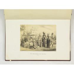
![[Views of Korea, Thailand, Cambodia and its inhabitants and princes. Including one or more phographes by Hippolyte Frandin.]](/uploads/cache/48426-250x250.jpg)
[Views of Korea, Thailand, Cambodia and its inhabitants and princes. Including one or more phographes by Hippolyte Frandin.]
A collection of 95 photographs, of which about 60 photos feature Korea or its people, printed on albumen paper. Captions in French. The others from Thailand, China, India...
- $25000 / ≈ €23393
Place & Date: C. 1892
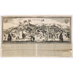
Naples. 1699. Nouvelle et exacte description de la tres-celebre & ancienne Ville de NAPLES
Only recorded broad sheet panoramic view of Naples with underneath in letter press a description of the town's history : "Nouvelle et exacte description de la tres-c...
Place & Date: Paris, 1699

Plan de Paris commencé l'année 1734, Dessiné et gravé sous les ordres de Messire Michel Etienne Turgot, prévost des marchands.
FIRST EDITION of Turgot's Monumental Joined View of Paris, stretching to over 10 Feet.This expansive engraved view of Paris covers the first eleven arrondissements of mod...
Place & Date: Paris, 1739

Group of 51 art déco gouaches.
Group of outstanding "art deco" gouaches (unsigned) from the workshop of "R. Pichon. Ateliers de Dessin et Lithographie – 10, rue Rochechouart – Paris&...
Place & Date: Paris, 1920-1930
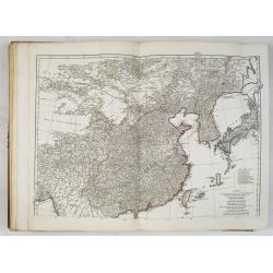
Atlas in elephant folio.
Most of D'Anville's atlases were made up for the individual customer, so no two appear alike. Many of the 59 pages are multi-sheet maps, so the actual map sheet count is ...
Place & Date: Paris, 1771-1786
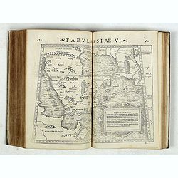
Strabonis nobilissimi et doctissimi philosophi ac geographi Rervm geographicarum commentarij libris XVII contenti, Latini facti Gvilielmo Xylandro Augustano interprete. . .
A few marginal annotations (pp. 109-111), in a 19th c. hand. Latin translation with a commentary by Wilhelm Holtzmann, also called Guglielmus Xylander. (1532-1576), libra...
- $15000 / ≈ €14036
Place & Date: Basle, Henri Petri, 1571
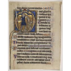
Illuminated leaf from a Psalter.
Very fine 20 lines illuminated leaf from a liturgical Psalter in Latin with the reading from the Vulgate Bible. Lines in a slightly irregular gothic hand, black ink, plum...
Place & Date: Flanders, Rhineland, or possibly England, c. 1280

Camden's Britannia, Newly Translated into English with Large Additions and Improvements.
Splendid copy fully original colored (inclusive title-cartouche) of the first edition of Gibson's translation.Illustrated with an engraved portrait of Camden by R. White,...
Place & Date: London, F. Collins for A. Swalle and A. / J. Churchill, 1695

A new and correct map of the world.
The early eighteen century was one of the most important periods for English cartography. One of the period's most intriguing world maps is this large scale map which off...
- $12000 / ≈ €11229
Place & Date: London 1714

Vue et perspective de la ville de Marseille et ses environs, prise du côté de la belle vue de la plaine St. Michel. Dediée à S. A. S. Mgr. le duc de Penthievre Grand Amiral de France. Par son très humble et très obéissant Serviteur Aulagnier.
Scarce large and spectacular panorama of the city and harbour of Marseille published in Paris in the middle of the 18th century. Engraved by Pierre Jacques Duret under th...
- $12000 / ≈ €11229
Place & Date: Paris, 1751

Neptune des Côtes Occidentales de France.
Large maritime atlas illustrated with a handwritten title, a table and 47 single or double page charts. The charts show the western coasts of France as well as the Spanis...
- $12000 / ≈ €11229
Place & Date: Paris, 1776-1822
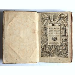
Traduzida palabra por palabra de la verdad Hebrayca, por muy excelentes letrados.
Complete title : Traduzida palabra por palabra de la verdad Hebrayca, por muy excelentes letrados. Vista y examinad a per el officio de la Inquisicion. Con Privilegio del...
- $8500 / ≈ €7954
Place & Date: Ampsterdam, Gillis Ioost, 1647
![Recueil de costumes. Imagini degl'abiti con cui Va uestita la Nobiltà della Serenis.ma Republica di Venezia. Suivi de: [Augsburger Kleidertrachten].](/uploads/cache/48425-250x250.jpg)
Recueil de costumes. Imagini degl'abiti con cui Va uestita la Nobiltà della Serenis.ma Republica di Venezia. Suivi de: [Augsburger Kleidertrachten].
Imagini degl'abiti con cui Va uestita la Nobiltà della Serenis.ma Republica di Venezia. Dedicate all'Illmo et Ecc.mo Sig.r Andrea da Leze Degnis.mo Proc.tor di S: Marco....
- $8500 / ≈ €7954
Place & Date: Venezia, Ragheno, 1702 / Augsbourg, J. Wolff, ca. 1715
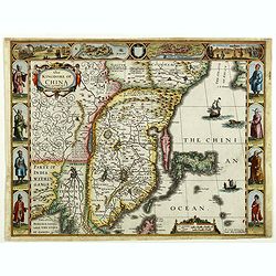
The Kingdome of China.
A most sought-after map of China. Decorative border vignettes including views of the cities of Quinzay and Macao along the top border with the wheeled wind machines and p...
Place & Date: London, G. Humble, 1626
(Album Pallière. Escenas Americanas. Reduccion de Cuadros, aquarelles y bosquejos.)
51 (of 52 )beautifully lithographed plates on tinted ground, lithographed by J. Pelvilain after designs by Juan Léon Palliere. One plate missing : santiagueña tejiendo ...
- $10000 / ≈ €9357
Place & Date: Buenos Aires, en venta en la casa de los S.res Fusoni H.nos, ca. 1850

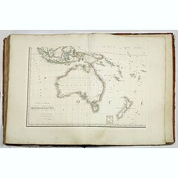
Voyage de découvertes aux Terres Australes. Historique. Atlas Deuxième partie.
First edition of the second part of the atlas by Freycinet, part of his important book "Voyage de découvertes aux Terres Australes". Illustrated with two foldi...
- $7500 / ≈ €7018
Place & Date: Paris, Langlois, 1811
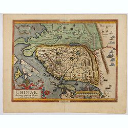
Chinae, olim Sinarum Regionis, nova descriptio. Auctore Ludovico Georgio.
The first map of China ever to appear in a Western atlas, west to the top. The second state with "Las Philipinas" somewhere in 1587 added to the plate. When thi...
- $6000 / ≈ €5614
Place & Date: Antwerp, 1592
![Le Isole di Sandwich delineate sulle osservazioni del Cap Cook. [Hawaii]](/uploads/cache/43195-250x250.jpg)
Le Isole di Sandwich delineate sulle osservazioni del Cap Cook. [Hawaii]
FIRST EDITION on laid paper. Cassini’s splendid map depicts Sandwich islands, old name for Hawaii islands, at the end of the eighteenth century. The splendid cartouche ...
Place & Date: Rome, 1798
Het Groote Tafereel der Dwaasheid, vertoonende de opkomst, voortgang en ondergang der Actie, Bubbel en Windnegotie, in Vrankryk, Engeland, en de Nederlanden, ...
FIRST ISSUE of this biting and vulgar satire on the Mississippi and South Sea Bubbles and an extraordinary visual record with 78 plates of the first banking crash, show...
- $7500 / ≈ €7018
Place & Date: Amsterdam, 1720

Americae Nova Tabula.
An inset shows Greenland and Iceland. Decorative elements include ships, sea monsters, and vignettes of native Americans within South America. In addition, the map is bor...
- $7500 / ≈ €7018
Place & Date: Amsterdam, 1644
Incliti Cantonis Friburgensis Tabula, autore Francisco Petro VON DER WEID. Senatore et Commissario generale Friburgi. anno Domini 1668.
Very rare 2-sheet map and the first map of the canton Fribourg (Freiburg) in a scale of Scale 1:120.000. South to the top.The area shown on the map encompasses the whole ...
- $7500 / ≈ €7018
Place & Date: Fribourg, 1668

Ambassades mémorables de la Compagnie des Indes orientales des Provinces Unies vers les empereurs du Japon.
First edition in French of this important work on Japan, a work whose illustrations "represent a high-water mark in book illustrations of the 17th century" (Lac...
- $5500 / ≈ €5146
Place & Date: Amsterdam, 1680

Gallia.
Extremely rare map of France, Netherlands, Southern England, Switzerland, and Northern Spain. This map was never regularly included in the Theatrum; Denuce mentions the i...
Place & Date: Antwerp, ca 1598
Grand atlas universel ou collection de cartes encyprotypes, générales et détaillées des cinq parties du monde.
Large folio atlas containing 8 general one-sheet maps, and 8 detailed four-sheet maps: Containing2 World maps- "Mappe-monde sur la projection de Mercator. Carte ency...
- $6000 / ≈ €5614
Place & Date: Paris, Desray, 1816

Carte d'Asie divisée en ses principaux Etats.
Uncommon and decorative "carte à figures" wall map, prepared by Clouet, with superb decoration including a wonderful rococo border with vignettes describing hi...
Place & Date: Paris, Mondhare, 1787
Der curiose und ... Nüssliche Dollmetscher..
Rare atlas and containing geographical descriptions of all continents. Illustrated with 30 very finely engraved and beautifully colored maps in attractive original strong...
- $6000 / ≈ €5614
Place & Date: Augsburg, 1748