Browse Listings

French composite atlas made up of rare maps published by Parisian editors from the 17th century , mainly by G. Jollain including scarce maps of America.
A rare French composite atlas including 90 maps, published by Parisian publishers from the 17th century, mainly by Gérard I Jollain, or by maps bought from Dutch publish...
Place & Date: Paris, ca. 1675
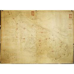
Militairy manuscript map of the end of Yangzi River across Shanghai, Jiangsu, and Zhejiang areas, with 3 red seals of the Ever-Victorious Army.
In lower left corner an inset plan of Songjiang District with Shanghai with a grid and the area is divided with red doted border lines.The map has three red seals of the ...
Place & Date: China, ca 1862

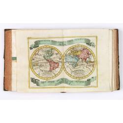
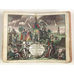
Le Nouveau miroir des voiages marins de la navigation de la mer occidentale & orientale.
A second and final French edition of this important sea atlas. Two engraved frontispieces, figure with volvelle, full-page figure, 48 double-page charts (one numbered 19....
- $120000 / ≈ €112286
Place & Date: Antwerp, Chez Iean Bellere, a l’Aigle d’or, l’An M.CCCCCC (1600
![[A magnificent 18 inch. (46 cm.) diameter celestial globe] URANOGRAPHIA / SYDERUM ET STELLARUM / in Singulis Syderibus conspicuarum / exhibens Delineationem accuratissimam, / qua / ex Observationibus Astronomi plane Singularis / IOHANIS HEVELII...](/uploads/cache/48959-250x250.jpg)
[A magnificent 18 inch. (46 cm.) diameter celestial globe] URANOGRAPHIA / SYDERUM ET STELLARUM / in Singulis Syderibus conspicuarum / exhibens Delineationem accuratissimam, / qua / ex Observationibus Astronomi plane Singularis / IOHANIS HEVELII...
RARE FIRST STATE OF THIS CELESTIAL TABLE GLOBE, 46 cm in diameter, produced by Gerard and Leonard Valk at the beginning of the 18th century. The globe comprises of t...
- $95000 / ≈ €88893
Place & Date: Amsterdam, 1711
L’Atlas de la Mer ou Monde aquaticque.
Original blind-stamped vellum binding ; attractive ORIGINAL HAND-COLOR in outline with cartouches, windroses and decoration in full orginal color ; internally some usual ...
- $75000 / ≈ €70179
Place & Date: Amsterdam, sur le Cay de Teexel, prez du Rams-Koy, au miroir de la Mer, 1670
Atlas van Zeevaert en Koophandel door de Geheele Weereldt.
Engraved frontispiece, title printed in red and black with engraved vignette, engraved dedication to the Dutch East India Company, 32 double-page engraved charts with con...
- $65000 / ≈ €60822
Place & Date: Amsterdam, 1745
Atlas van Zeevaert en Koophandel door de Geheele Weereldt.
Engraved frontispiece, title printed in red and black with engraved vignette, engraved dedication to the Dutch East India Company, 32 double-page engraved charts in very ...
- $50000 / ≈ €46786
Place & Date: Amsterdam, 1745
J.Horsburgh/ R.H.Bate / G.H.Stapleton. The two chart books are bound in contemp. half calf, and include together 57 of the most up-to-date French (Depot général de la marine) and English (Hydrographic Office) charts available in 1847 for sailing t
BOOK 1 : Mainly charts by "Dépôt Général de la Marine" including 20 folding charts. The binding measuring 665x275mm, the charts mostly 595x910mm.1. Dépôt ...
- $50000 / ≈ €46786
Place & Date: Paris, London, Hong Kong, 1835 - 1849
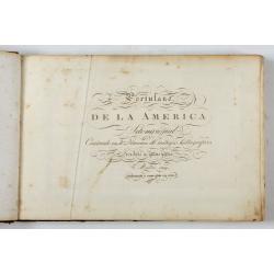
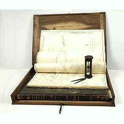
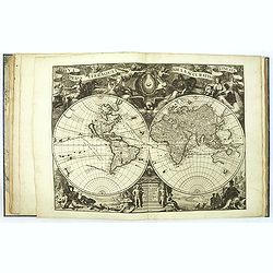
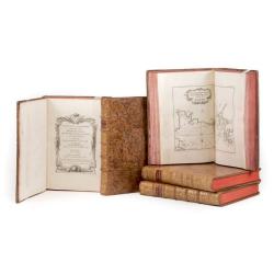
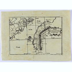
Portulano de la Ameririca Setentrional construido en la direccion de tabajos.
The Portulano de la America Setentrional, is an exceedingly rare Spanish sea atlas featuring charts of the Caribbean and the Gulf of Mexico. It was developed by the astr...
- $45000 / ≈ €42107
Place & Date: Madrid, 1818
![DE WIT, Frederick. [Zee Atlas].](/uploads/cache/48904B-250x250.jpg)
DE WIT, Frederick. [Zee Atlas].
The charts are in very good condition, dark imprints and very decorative original strong coloring. A few have some very minor restoration in very few places, printed on s...
- $32000 / ≈ €29943
Place & Date: Amsterdam, ca. 1680

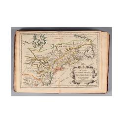
Connecticut and Parts adjacent at Amsterdam. .
A nice example of this early map of the state of Connecticut with part of Rhode Island to the east, Long Island to the south, and New York to the east. Rivers, roads, t...
- $30000 / ≈ €28072
Place & Date: Amsterdam, 1780
![Shintei Bankoku Zenzu [Revised Comprehensive Map of All Countries]](/uploads/cache/48437-250x250.jpg)
Shintei Bankoku Zenzu [Revised Comprehensive Map of All Countries]
Compiled by Kageyasu Takahashi, the finest world map of the Edo period, copper plate print, 1810. Bunka 7 is dated from the preface on this map,This world map, published ...
- $26000 / ≈ €24329
Place & Date: Kyoto, Bunka 7 or 1810
Le Nouveau Theatre du Monde, ou la Geographie Royale composée de nouvelles cartes tres-exactes..
Pieter van der Aa (1659 1733) was a prolific late seventeenth and early eighteenth-century publisher. His output was not just restricted to atlases: he also produced topo...
Place & Date: Amsterdam, 1720
Le Petit atlas maritime. Recueil de cartes et plans des quatre parties du monde, en cinq volumes.
FIRST EDITION. A large paper copy, in attrictive original colors. Jacques Nicolas Bellin held offical status as royal hydrographer and ingéniuer géographe de la marine ...
- $45000 / ≈ €42107
Place & Date: Paris, 1764
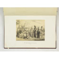
![[Views of Korea, Thailand, Cambodia and its inhabitants and princes. Including one or more phographes by Hippolyte Frandin.]](/uploads/cache/48426-250x250.jpg)
[Views of Korea, Thailand, Cambodia and its inhabitants and princes. Including one or more phographes by Hippolyte Frandin.]
A collection of 95 photographs, of which about 60 photos feature Korea or its people, printed on albumen paper. Captions in French. The others from Thailand, China, India...
- $25000 / ≈ €23393
Place & Date: C. 1892
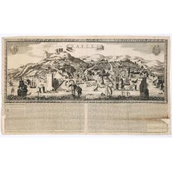
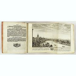
Naples. 1699. Nouvelle et exacte description de la tres-celebre & ancienne Ville de NAPLES
Only recorded broad sheet panoramic view of Naples with underneath in letter press a description of the town's history : "Nouvelle et exacte description de la tres-c...
Place & Date: Paris, 1699

Plan de Paris commencé l'année 1734, Dessiné et gravé sous les ordres de Messire Michel Etienne Turgot, prévost des marchands.
FIRST EDITION of Turgot's Monumental Joined View of Paris, stretching to over 10 Feet.This expansive engraved view of Paris covers the first eleven arrondissements of mod...
Place & Date: Paris, 1739

Group of 51 art déco gouaches.
Group of outstanding "art deco" gouaches (unsigned) from the workshop of "R. Pichon. Ateliers de Dessin et Lithographie – 10, rue Rochechouart – Paris&...
Place & Date: Paris, 1920-1930
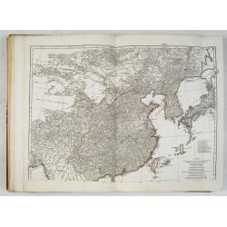
Atlas in elephant folio.
Most of D'Anville's atlases were made up for the individual customer, so no two appear alike. Many of the 59 pages are multi-sheet maps, so the actual map sheet count is ...
Place & Date: Paris, 1771-1786
Strabonis nobilissimi et doctissimi philosophi ac geographi Rervm geographicarum commentarij libris XVII contenti, Latini facti Gvilielmo Xylandro Augustano interprete. . .
A few marginal annotations (pp. 109-111), in a 19th c. hand. Latin translation with a commentary by Wilhelm Holtzmann, also called Guglielmus Xylander. (1532-1576), libra...
- $15000 / ≈ €14036
Place & Date: Basle, Henri Petri, 1571
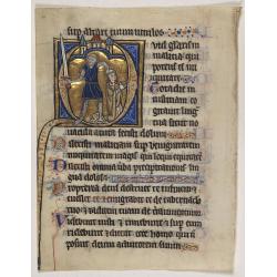
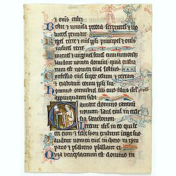
Illuminated leaf from a Psalter.
Very fine 20 lines illuminated leaf from a liturgical Psalter in Latin with the reading from the Vulgate Bible. Lines in a slightly irregular gothic hand, black ink, plum...
Place & Date: Flanders, Rhineland, or possibly England, c. 1280
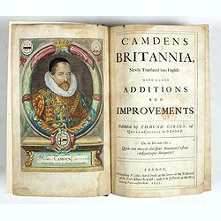
Camden's Britannia, Newly Translated into English with Large Additions and Improvements.
Splendid copy fully original colored (inclusive title-cartouche) of the first edition of Gibson's translation.Illustrated with an engraved portrait of Camden by R. White,...
Place & Date: London, F. Collins for A. Swalle and A. / J. Churchill, 1695

A new and correct map of the world.
The early eighteen century was one of the most important periods for English cartography. One of the period's most intriguing world maps is this large scale map which off...
- $12000 / ≈ €11229
Place & Date: London 1714

Vue et perspective de la ville de Marseille et ses environs, prise du côté de la belle vue de la plaine St. Michel. Dediée à S. A. S. Mgr. le duc de Penthievre Grand Amiral de France. Par son très humble et très obéissant Serviteur Aulagnier.
Scarce large and spectacular panorama of the city and harbour of Marseille published in Paris in the middle of the 18th century. Engraved by Pierre Jacques Duret under th...
- $12000 / ≈ €11229
Place & Date: Paris, 1751
Cartes et tables de la géographie physique ou naturelle. Présentées au Roi le 15. Mai 1757.
A selection of maps demonstrating Philippe Buache's methods of constructing maps from the observations and reports of sailors and navigators of various parts of the world...
- $8500 / ≈ €7954
Place & Date: Paris, 1757

Neptune des Côtes Occidentales de France.
Large maritime atlas illustrated with a handwritten title, a table and 47 single or double page charts. The charts show the western coasts of France as well as the Spanis...
- $12000 / ≈ €11229
Place & Date: Paris, 1776-1822
![Recueil de costumes. Imagini degl'abiti con cui Va uestita la Nobiltà della Serenis.ma Republica di Venezia. Suivi de: [Augsburger Kleidertrachten].](/uploads/cache/48425-250x250.jpg)
Recueil de costumes. Imagini degl'abiti con cui Va uestita la Nobiltà della Serenis.ma Republica di Venezia. Suivi de: [Augsburger Kleidertrachten].
Imagini degl'abiti con cui Va uestita la Nobiltà della Serenis.ma Republica di Venezia. Dedicate all'Illmo et Ecc.mo Sig.r Andrea da Leze Degnis.mo Proc.tor di S: Marco....
- $8500 / ≈ €7954
Place & Date: Venezia, Ragheno, 1702 / Augsbourg, J. Wolff, ca. 1715
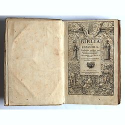
Traduzida palabra por palabra de la verdad Hebrayca, por muy excelentes letrados.
Complete title : Traduzida palabra por palabra de la verdad Hebrayca, por muy excelentes letrados. Vista y examinad a per el officio de la Inquisicion. Con Privilegio del...
- $8500 / ≈ €7954
Place & Date: Ampsterdam, Gillis Ioost, 1647
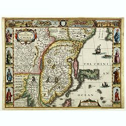
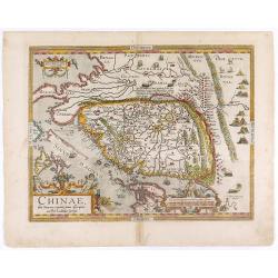
The Kingdome of China.
A most sought-after map of China. Decorative border vignettes including views of the cities of Quinzay and Macao along the top border with the wheeled wind machines and p...
Place & Date: London, G. Humble, 1626
(Album Pallière. Escenas Americanas. Reduccion de Cuadros, aquarelles y bosquejos.)
51 (of 52 )beautifully lithographed plates on tinted ground, lithographed by J. Pelvilain after designs by Juan Léon Palliere. One plate missing : santiagueña tejiendo ...
- $10000 / ≈ €9357
Place & Date: Buenos Aires, en venta en la casa de los S.res Fusoni H.nos, ca. 1850

Voyage de découvertes aux Terres Australes. Historique. Atlas Deuxième partie.
First edition of the second part of the atlas by Freycinet, part of his important book "Voyage de découvertes aux Terres Australes". Illustrated with two foldi...
- $7500 / ≈ €7018
Place & Date: Paris, Langlois, 1811
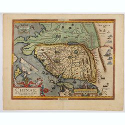
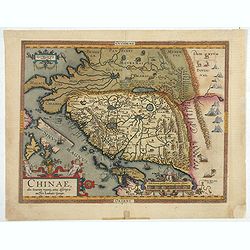
Chinae, olim Sinarum Regionis, nova descriptio. Auctore Ludovico Georgio.
The first map of China ever to appear in a Western atlas, west to the top. The second state with "Las Philipinas" somewhere in 1587 added to the plate. When thi...
- $6000 / ≈ €5614
Place & Date: Antwerp, 1592

Carte d'Asie divisée en ses principaux Etats.
Uncommon and decorative "carte à figures" wall map, prepared by Clouet, with superb decoration including a wonderful rococo border with vignettes describing hi...
Place & Date: Paris, Mondhare, 1787
Der curiose und ... Nüssliche Dollmetscher..
Rare atlas and containing geographical descriptions of all continents. Illustrated with 30 very finely engraved and beautifully colored maps in attractive original strong...
- $6000 / ≈ €5614
Place & Date: Augsburg, 1748

Americae Nova Tabula.
An inset shows Greenland and Iceland. Decorative elements include ships, sea monsters, and vignettes of native Americans within South America. In addition, the map is bor...
- $7500 / ≈ €7018
Place & Date: Amsterdam, 1644
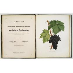
Atlas der für den Weinbau Deutschlands und Oesterreichs werthvollsten Traubensorten. Mit genauer Beschreibung der Eigenschaften, Cultur-Methoden und des Schnittes...
Atlas der für den Weinbau Deutschlands und Oesterreichs werthvollsten Traubensorten. Mit genauer Beschreibung der Eigenschaften, Cultur-Methoden und des Schnittes, der A...
Place & Date: Vienne, Wien, Faesy und Frick, 1873-1876

Ambassades mémorables de la Compagnie des Indes orientales des Provinces Unies vers les empereurs du Japon.
First edition in French of this important work on Japan, a work whose illustrations "represent a high-water mark in book illustrations of the 17th century" (Lac...
- $5500 / ≈ €5146
Place & Date: Amsterdam, 1680

Gallia.
Extremely rare map of France, Netherlands, Southern England, Switzerland, and Northern Spain. This map was never regularly included in the Theatrum; Denuce mentions the i...
Place & Date: Antwerp, ca 1598
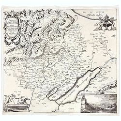
Incliti Cantonis Friburgensis Tabula, autore Francisco Petro VON DER WEID. Senatore et Commissario generale Friburgi. anno Domini 1668.
Very rare 2-sheet map and the first map of the canton Fribourg (Freiburg) in a scale of Scale 1:120.000. South to the top.The area shown on the map encompasses the whole ...
- $7500 / ≈ €7018
Place & Date: Fribourg, 1668
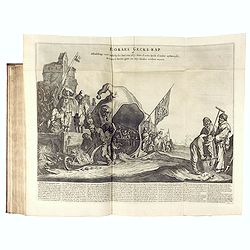
Het Groote Tafereel der Dwaasheid, vertoonende de opkomst, voortgang en ondergang der Actie, Bubbel en Windnegotie, in Vrankryk, Engeland, en de Nederlanden, ...
FIRST ISSUE of this biting and vulgar satire on the Mississippi and South Sea Bubbles and an extraordinary visual record with 78 plates of the first banking crash, show...
- $7500 / ≈ €7018
Place & Date: Amsterdam, 1720
Introduction à la géographie en plusieurs cartes avec leur explication. Par les Srs Sanson Géographes Ordinaires du Roy. Dédiée à Monseigneur Jean Paul Bignon.
An extremely rare scientific atlas, published in 1707, followed by 29 maps published and oft corrected by P. Moullart-Sanson, with 18 maps relating to the Americas.First ...
- $7500 / ≈ €7018
Place & Date: Paris, Dans le Cloître de St Nicolas du Louvre, 1707
Grand atlas universel ou collection de cartes encyprotypes, générales et détaillées des cinq parties du monde.
Large folio atlas containing 8 general one-sheet maps, and 8 detailed four-sheet maps: Containing2 World maps- "Mappe-monde sur la projection de Mercator. Carte ency...
- $6000 / ≈ €5614
Place & Date: Paris, Desray, 1816
![Le Isole di Sandwich delineate sulle osservazioni del Cap Cook. [Hawaii]](/uploads/cache/43195-250x250.jpg)
Le Isole di Sandwich delineate sulle osservazioni del Cap Cook. [Hawaii]
FIRST EDITION on laid paper. Cassini’s splendid map depicts Sandwich islands, old name for Hawaii islands, at the end of the eighteenth century. The splendid cartouche ...
Place & Date: Rome, 1798
Atlas Minor praecipua Orbis Terrarum Imperia, Regna et Provincias Germinae Potissimum, tabellis 50 exacte delineatis fiftens usui militiae ducum ac peregrinantium maxime accommodatus opera.
This collection of highly attractive maps were drawn by Georg Matheus Seutter and his son Albrecht Carl. Georg Matheus was one of the most important German Cartographers ...
- $5250 / ≈ €4913
Place & Date: Augsburg, 1744
![[12 volumes] Recueil des voyages qui ont servi à l'établissement et aux progrez de la Compagnie des Indes Orientales, forméedans les Provinces-Unies des Païs-Bas...](/uploads/cache/43700-250x250.jpg)
[12 volumes] Recueil des voyages qui ont servi à l'établissement et aux progrez de la Compagnie des Indes Orientales, forméedans les Provinces-Unies des Païs-Bas...
An important richly illustrated compendium of the first Dutch voyages to East India, of great interest for the history and establisment of the Dutch global trade, particu...
- $5000 / ≈ €4679
Place & Date: Rouen, Pierre Le Boucher, 1725
![[Ritter Sundial Map of the World]](/uploads/cache/60731-250x250.jpg)
[Ritter Sundial Map of the World]
This highly unusual map projects the world from the north pole as though it were the table of a sundial, with the land masses drawn to scale in proportion to their distan...
- $4500 / ≈ €4211
Place & Date: Nuremberg, 1640
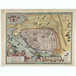
Chinae, olim Sinarum regionis. . .
The first printed map of China. It is signed by Ludovico Georgio, whose real name was Luis Jorge de Barbuda. He was a Portuguese Jesuit cartographer and besides that a sp...
- $6000 / ≈ €5614
Place & Date: Antwerp, 1608
Theatro del Mondo di Abrahamo Ortelio..
Including maps of the world (Shirley, World 214): Europe; Asia; America (Burden, America 126, Marchetti 1598); Africa; England; Scotland; Ireland; Tercera; Spain (4); Por...
Place & Date: Venice, G. Turrini, 1655
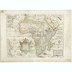
Africa ex magnae Orbis Terrae Descriptione.
Very rare separately published "Lafreri" map of Africa. The title in typical Italian scrollwork surmounted by two Cupids in the lower Atlantic. A dedication to ...
- $6000 / ≈ €5614
Place & Date: Venice, ca. 1590
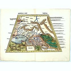
Septima Asie Tabvla.
Trapezoidal woodcut map showing the area around the Caspian Sea from Martin Waldseemüller's most important 1513 edition of Ptolemy, which was a landmark work that contri...
- $6000 / ≈ €5614
Place & Date: Strasburg, J. Schott, 1513
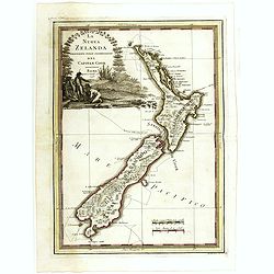
La nuova Zelanda delineate sulle ultima osservazioni del Capitan Cook.
First edition on laid paper Cassini’s splendid early map of New Zealand, being the most decorative version of Captain Cook's map of New Zealand, published in the very s...
Place & Date: Rome, 1798
Chinae, olim Sinarum regionis. . .
The first printed map of China. It is signed by Ludovico Georgio, whose real name was Luis Jorge de Barbuda. He was a Portuguese Jesuit cartographer and besides that a sp...
Place & Date: Antwerp, 1598
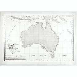
Carte Generale de la Nouvelle Hollande.
Fine map of the continent of Australia prepared by Louis Freycinet during his voyage under Captain Thomas Baudin in 1800-1803. Freycinet's map of New Holland was the firs...
- $5000 / ≈ €4679
Place & Date: Paris, Imprimerie Royale, 1811

Americae Nova Tabula.
The delineation of the coast and the nomenclature on both the Pacific and Atlantic coasts are basically Spanish in origin and follow the maps of Ortelius and Wytfliet. To...
- $7500 / ≈ €7018
Place & Date: Amsterdam, 1645
![[Toscana / Tuscany] En, candidi lectores, elegantioris Italiae partis, Tusciae scilicet, topographiam. aenis nris formis excussam in hac Tabella vobis denuo damus. . .](/uploads/cache/47717-250x250.jpg)
[Toscana / Tuscany] En, candidi lectores, elegantioris Italiae partis, Tusciae scilicet, topographiam. aenis nris formis excussam in hac Tabella vobis denuo damus. . .
A rare map of Tuscany, including the islands of Elba, Giglio, Giannutri and part of Corsica, and covering the whole of Tuscany, part of Liguria, Lombardy, Emilia, Umbria,...
- $6000 / ≈ €5614
Place & Date: Rome, ca 1557
Neue und vollständige Topographie der Eidgnossschaft, in welcher die in den dreyzehen und zugewandten auch verbündeten Orten und Landen dermal befindliche Städte, Bischthümer, Stifte, Klöster, Schlösser, Amts-Häuser, Edelsitze und Burgställe...
The first edition of Herrliberger's work on the topography of Switzerland. - The rarest book on Switzerland rarely found complete.Illustrated with an engraved allegorical...
- $5500 / ≈ €5146
Place & Date: Zurich, Johann Kaspar Ziegler, 1754-1773

La Nuova Olanda e La Nuova Guinea delineate sulle ultima osservazioni.
Cassini’s splendid and rare map of Australia and New Guinea, from the 'Nuovo Atlante Geografico Universale'. The emphasis of the map is the charting of Captain Cook dow...
Place & Date: Rome, 1798
Mapa De la parte de la Isla Formosa sa perteneciente al Emperadotde la China sacado por Ord. De S.M.
Very rare map of Taiwan and the neighboring coastline of China, engraved by Cipriano Bagay in Manila, one of the few maps published in the Philippines in the 18th Century...
- $6000 / ≈ €5614
Place & Date: Manilla, 1788
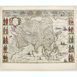
![A New and Correct Map of Asia Laid down from the latest and best Observations Humbly Inscribed to his Royal Highness George, Prince of Wales. . . [2 subtitles:] Several Representations of the Customs Manners etc. of Divers Parts of Asia. . .](/uploads/cache/35765-250x250.jpg)
A New and Correct Map of Asia Laid down from the latest and best Observations Humbly Inscribed to his Royal Highness George, Prince of Wales. . . [2 subtitles:] Several Representations of the Customs Manners etc. of Divers Parts of Asia. . .
A large, attractive and rare, separately issued map of Asia with figured side borders. With large decorative title cartouche ad address "By Thomas Kitchin. London, p...
- $5500 / ≈ €5146
Place & Date: London, 1787
Illuminated leaf from a liturgical Psalter.
Very fine illuminated leaf from a liturgical Psalter in Latin with the reading from the Vulgate Bible. Lines in a slightly irregular Gothic hand, black ink, plummet rulin...
Place & Date: England, c. 1280
![[Tableau Général de l'Empire Ottoman]. 11 plates with the panoramic view of Mecca.](/uploads/cache/41513-250x250.jpg)
[Tableau Général de l'Empire Ottoman]. 11 plates with the panoramic view of Mecca.
A collection of 11 engraved plates (3 folding) from "Tableau Général de l'Empire Ottoman", Paris, Imprimerie de Monsieur, 1790, comprising the famous panorami...
- $3800 / ≈ €3556
Place & Date: Paris, 1790
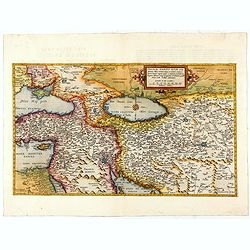
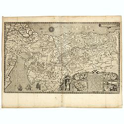
Primae Partis Asiae.
The Very Rare First State. Turkey/ Holy Land/ Iran/ Iraq/ Arabia/ Afghanistan. A superb example of the rare 1578 edition of this fine map of the Middle East, spanning fro...
- $4500 / ≈ €4211
Place & Date: Antwerp, 1578
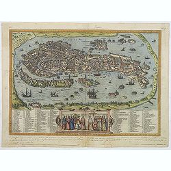
Venise / Ville capitale de la République de même nom en Italie.
A very decorative and extremely rare of Venice, including a numbered legend in lower part. Published by Jacques Chéreau, (1688 - 1776). Engraved by Pierre-Alexandre Ave...
- $4000 / ≈ €3743
Place & Date: Paris, ca.1750

(Lübeck) Lvbeca vrbs. imperialis libera. civitatvm. Wandalicarvm. . . .
Impressive more than 3 meters wide panoramic town view after a woodblock engraving from Elias Diebel, initially made in 1552. Of this original woodblock, Bachmann mention...
- $4500 / ≈ €4211
Place & Date: Germany, c. 1855
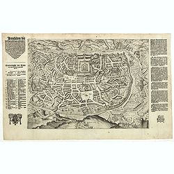
Jerusalem die Heijlighe Stadt van God. . .
Very rare separately plan of the Jerusalem engraved by Joannes van Doetecum Jr. Variant to Poortman, Kaarten in Bijbels, map 64. In lower part the copper plate has been s...
- $5000 / ≈ €4679
Place & Date: Amsterdam, 1598
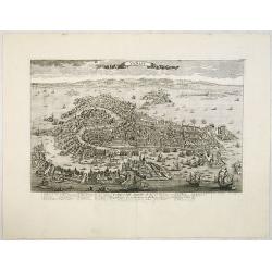
Venetia. (Venice)
Precise, beautiful bird's-eye town-view of Venice, clearly depicting the city's architectural landmark. The surrounding lagoon is animated with a great variety of sailing...
Place & Date: Cologne, 1590
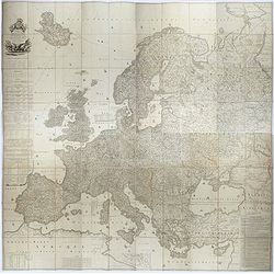
Carte de l'Europe dediée a Son Altesse royale Monseigneur Charles Louis archiduc d'Autriche, prince royal de Hongrie et de Bohéme, chevalier de la Toison d'Or, Grand-Croix de l'ordre...
Probably the largest published map of Europe during the regime of Napoleon.In upper left corner a large title cartouche with coats of arms and a dedication to Archduke Ch...
- $4000 / ≈ €3743
Place & Date: Paris, 1803
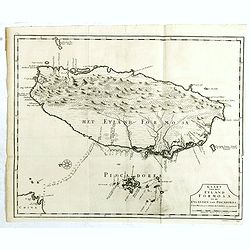
Kaart van het Eyland Formosa en de Eylanden van Piscadores.
The earliest printed map of Taiwan or Formosa. Oriented to the east, with north at the left, covering the entire island and the nearby Pescadores, now known as the Penghu...
- $4000 / ≈ €3743
Place & Date: Amsterdam, 1724
![[East coast of Africa, Arabia and west coast of India.]](/uploads/cache/04762-250x250.jpg)
[East coast of Africa, Arabia and west coast of India.]
Rare. Map of the east coast of Africa, Including Madagascar, the Arabian Peninsular, coast of Pakistan and west coast of India.Prepared by Joao Teixeira in 1649, this cha...
Place & Date: Paris, 1664-1696

.Pascaerte Vande Zuyd-Zee tusschen California, en Ilhas de Ladrones. . .
A decorative and most interesting map - being one of the earliest of the Pacific to record the observations of Tasman's voyages. The northern part of the island of Califo...
Place & Date: Amsterdam, 1666
L'Amerique, en plusieurs cartes nouvelles, et exactes, &c. En divers traitez de geographie, et d'histoire. Là où sont descrits succinctement, & avec une belle Methode, & facile.
Third edition, the text and maps of which are identical to the first given in 1657. However, the dedication to Nicolas Fouquet (2 pp.), disgraced in 1661, has been delete...
- $4500 / ≈ €4211
Place & Date: Paris, 1680
Carte Generale de la Terre Napoleon (à la Nouvelle Hollande)... par M.L. Freycinet an 1808.
Fine map of part of Australia prepared by Louis Freycinet during his voyage under Captain Thomas Baudin in 1800-1803. The longitude is calculated from Paris.The cartouche...
- $4000 / ≈ €3743
Place & Date: Paris, Imprimerie Royale, 1811
Nova exactissimaque descriptio Danubii.
Rare loose impression of de Jode's map of the Danube with the surrounding countries with de Jode's imprint replaced by Theodor Galle's one. Without letterpress text on ve...
- $4000 / ≈ €3743
Place & Date: Antwerp, 1600
Asia noviter delineata. . .
From 1633 the members of the Blaeu family were official cartographers to the United East India Company and, as such, had access to the most up-to-date cartographic inform...
- $3500 / ≈ €3275
Place & Date: Amsterdam, 1644
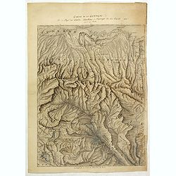
Carte de la Georgie et du Pays des Ossetes, Tcherkesses et Mitzdcheghi, Par Jules Klaproth (1823).
Detailed manuscript map of Georgia, based upon an 1823 map by Jules Klaproth. The map depicts the rugged terrain of Georgia and southern Russia in impressive detail from ...
- $4000 / ≈ €3743
Place & Date: Paris, ca. 1823
Pere Grinatie. De Reijse der Kinderen Israels so zij wt Egip . . . Africa - SW coast Table Bay surveyed by Mr F Skead Master RN assisted by Mr Charles Watermeyer 1858-60
Very rare separately map of the Holy Land engraved by Joannes van Doetecum Jr.In lower right corner inset with title cartouche surrounded by Aaron, the encampment of the ...
- $3500 / ≈ €3275
Place & Date: Amsterdam, 1598, The Hague, 1632
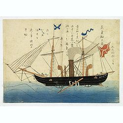
'Jokisen no zu' (Steamboat)
Nagasaki-e original Japanese woodblock print of a Steamboat. The figurehead is a striking detail.Nagasaki-e are Japanese woodblock prints that depict foreigners (Mostly ...
- $3750 / ≈ €3509
Place & Date: Nagasaki, c.1805
Chinae, olim Sinarum Regionis, nova descriptio. Auctore Ludovico Georgio.
The first map of China ever to appear in a Western atlas, west to the top. When this map appeared, it was by far the most accurate one of China.The map is based on a manu...
- $5500 / ≈ €5146
Place & Date: Antwerp, 1608 /1612

L'Amérique divisée en ses principaux Etats Dressée d'après les Cartes de Mr. Bonne?
Rare, wall map of America in 2 sheets, after R. Bonne. With 3 inset maps of Hispaniola, Martinique and Hudson Bay. Beautiful title cartouche depicting a Native American l...
Place & Date: Paris, 1788

Royaume de Corée.
With a quite elaborately pictorial cartouche, engraved by G.Kondet. One of the earliest separate maps of Korea. Jean Baptiste Bourguignon d' Anville (1697-1782), French c...
Place & Date: The Hague, 1737