Browse Listings in Asia
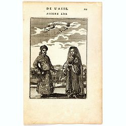
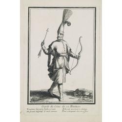
Mongols (De L'Asie / figure LIII).
A fine and uncommon early 17th century print of a Mogol couple.From the French text edition of "Description d'Univers", 1683. by Allain Manneson Mallet (1630-17...
- $80 / ≈ €70
Date: Paris, 1683
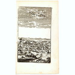
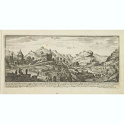
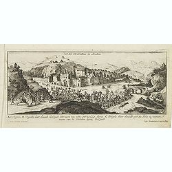
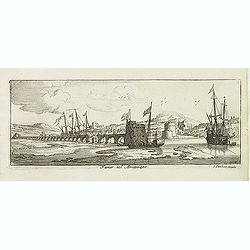
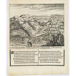
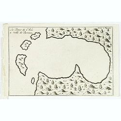
Ardeuil ou Ardebil.
A fine and uncommon early 17th century birds-eye view of Ardeuil in Iran, Persia.From the French text edition of Description d'Univers, 1683. by Allain Manneson Mallet (1...
- $80 / ≈ €70
Date: Paris, 1683
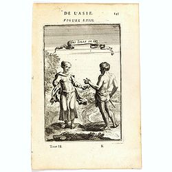
Habitants des Isles de la Sonde.
A fine and uncommon early 17th century print of two inhabitants of the Sunda Islands, East Indies (Indonesia).From the French text edition of Description d'Univers, 1683....
- $75 / ≈ €66
Date: Paris, 1683
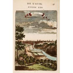
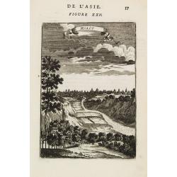
Miaco.
A late 17th-century miniature view of the skyline of Miaco (Kyoto). By Allain Manesson Mallet (1630-1706), a well-traveled military engineer and geographer who worked in ...
- $225 / ≈ €197
Date: Paris, 1683
Miaco.
A late 17th-century miniature view of the skyline of Miaco (Kyoto). By Allain Manesson Mallet (1630-1706), a well-traveled military engineer and geographer who worked in ...
- $200 / ≈ €175
Date: Paris, 1683
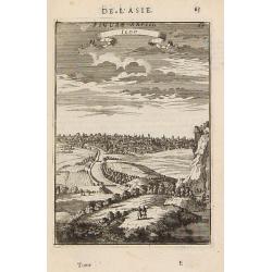
Iedo. (Tokyo)
A late 17th-century miniature view of the skyline of Edo (Tokyo). By Allain Manesson Mallet (1630-1706), a well-traveled military engineer and geographer who worked in 17...
- $200 / ≈ €175
Date: Paris, 1683
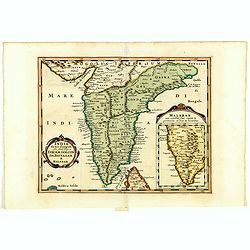
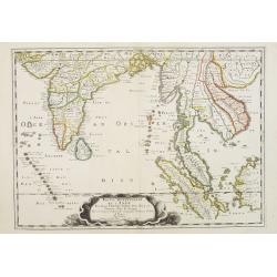
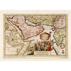
India extra Gangem . . .
Map covering the subcontinent from the Bay of Bengal and the Gulf of Cambay to Ceylon (Sri Lanka) and offers impressive detail given that the interior of India was largel...
- $300 / ≈ €262
Date: Utrecht / Amsterdam, J.Halma, 1683
![Isole dell 'India cioè le Molucche le Filippine e della Sonda . . . [East Indies].](/uploads/cache/39593-250x250.jpg)
Isole dell 'India cioè le Molucche le Filippine e della Sonda . . . [East Indies].
In lower left hand corner a large title cartouche, decorated with mermaids, mermen and playful putti. A scarce, uncommon, late 17th century map of South East Asia, based ...
- $1800 / ≈ €1572
Date: Rome, 1683
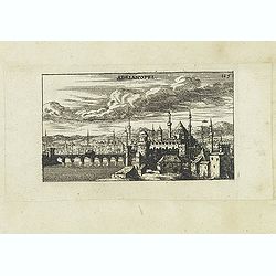
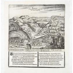
Adrianopel. (Edirne)
Panoramic view of Adrianopel or its modern name Edirne in European Turkey, near the border with Greece and Bulgaria. Published in "Der Donau-Strand Mit allen seinen ...
- $75 / ≈ €66
Date: Nuremberg, Jacob Sandrart, 1684
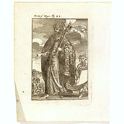
Der Grosse Mogol Fig LII.
A fine and uncommon early 17th century print of a Mogol.By Allain Manneson Mallet (1630-1706), a well traveled military engineer and geographer who worked in 17th century...
- $45 / ≈ €39
Date: Frankfurt, 1684
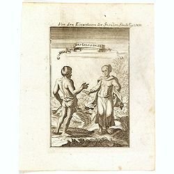
Von den Einwohnerne der Insulen Sonde (Fig LXIII).
A fine and uncommon early 17th century print of two inhabitants of the Sunda Islands, East Indies (Indonesia). Engraved by Joh. Jak. Vogel.By Allain Manneson Mallet (1630...
- $75 / ≈ €66
Date: Frankfurt, 1684

Die Mogoler (Fig LIII).
A fine and uncommon early 17th century print of a couple at time of the Mughal Empire. Engraved by Joh. Jak. Vogel.By Allain Manneson Mallet (1630-1706), a well traveled ...
- $40 / ≈ €35
Date: Frankfurt, 1684
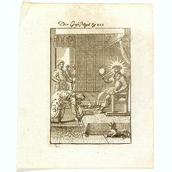
Grant Mogol - Der Graf Mogol (Fig LI).
A fine and uncommon early 17th century print of a Mughal emperor. Engraved by Joh. Jak. Vogel.By Allain Manneson Mallet (1630-1706), a well traveled military engineer and...
- $45 / ≈ €39
Date: Frankfurt, 1684
Avrengzebe Roy des Indes Orientales, si zelé po.r. la Religion de Mahomet ..
Very rare and decorative costume plate. Underneath the plate a descriptive text in French.Bears the address : Se vend à Paris chez F. Jollain l aine Rue St Jacques a la ...
Date: Paris, ca. 1685
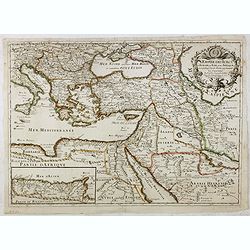
L'Empire des Turcs en Europe, en Asie et en Afrique.
A nice map showing the Turkish Empire, including an inset map of kingdom of Alger. Extending from Italy and the Eastern Mediterranean in the west to the Caspian Sea and P...
- $550 / ≈ €480
Date: Paris, 1686
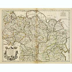
Partie Meridionale de l'Inde en deux presqu'isles. . .
Sanson's important mid-seventeenth century map of India and Southeast Asia, with the engraved date 1686, with the address "Aux Galleries du Louvre" added in bro...
- $800 / ≈ €699
Date: Paris, 1686
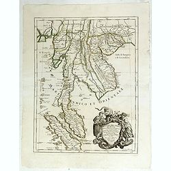
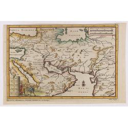
Penisola dell India di là dal Gange. . .
Giacomo Rossi's fine late 17th-century map of Malaysia, Thailand, Cambodia and part of Sumatra. Issued in Il Mercurio geografico In the lower right-hand corner a large ti...
Date: Rome, 1683-1688
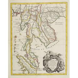
Penisola Dell India di la dal Gange Diusa ne i Regni, che in essasi contengono et accresciuta di varie notizie. Da Giacomo Cantelli da Vignola e conforme le Relationi di alcuni Padri della Compa di Giesu di Monsu Tavernier . . .
Giacomo Rossi's fine late 17th-century map of Malaysia, Thailand, Cambodia and part of Sumatra. The region is shown divided into kingdoms, including Tonkin, Cochinchina, ...
Date: Rome, 1683-1688
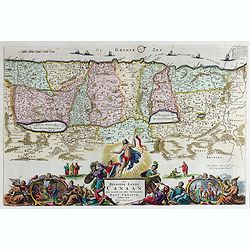
Het Beloofde Landt Canaan door wandelt onser Saligmaecker Jesu Christo neffens sijne Apostelen.
Fine map of the Land of Canaan or the Promised Land with north oriented to right. Large decorative title cartouche at bottom surrounded by vignettes depicting birth, deat...
Date: Amsterdam, 1688
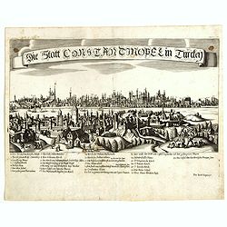
Constantinopolitanae urbis effigies ad vivum expressa.
Extremely rare panoramic view of Istanbul published by Jacob Koppmayr. With a numbered key (1-29) to principal places in town. Jacob Koppmayr was a printer and publisher ...
- $900 / ≈ €786
Date: Augsburg, 1689
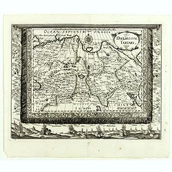
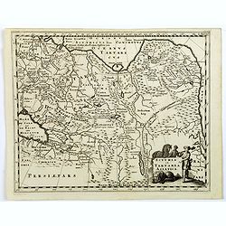
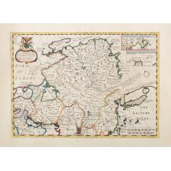
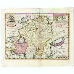
Die Grosse Tartari.
Rare map showing Siberia, Korea, with part of the Caspian Sea to the West, as well as India and North Russia. The title is in an oval cartouche in the upper right cornerT...
- $1000 / ≈ €874
Date: Augsburg, 1689
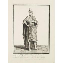
Femme Turque vestue a la moresque.
Beautiful engraving by Henri Bonnart (1642?-1711) vis-à-vis les Mathurins au Coq. Printed with the privilege of the King.
Date: Paris, 1690
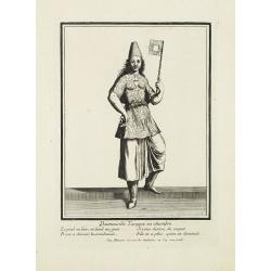
Damoiselle Turcque en chambre. . .
Beautiful engraving by Henri Bonnart (1642?-1711) vis-à-vis les Mathurins au Coq. Printed with the privilege of the King.
Date: Paris, 1690

Kam Hi Fils de Chien chi Empereur des Tartares orientaux?.plusieurs titres d'honneur Ecrits de sa propre main.
Very rare and decorative costume plate. Underneath the plate a descriptive text in French. Bears the address AParis Chez Nolin rue St. Jacques à l'Enseigne de la Place d...
- $300 / ≈ €262
Date: Paris ca. 1690
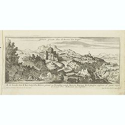
Gebort Plaedt Van S Ioannes des dooper. [Bith place of John Baptist)
Magnificent view of birthplace of John Baptist. Etched by Gaspar Bouttats (1640-1695).The Antwerp based publisher Jacques Peeters published ca. 1690 a series of prints re...
Date: Antwerp, c.1690
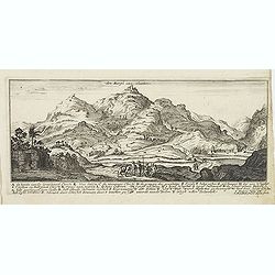
Den Bergh van olmeten. (Mount of Olives).
Magnificent view of the Mount of Olives, with the Church of the Ascension. Etched by Gaspar Bouttats (1640-1695).The Antwerp based publisher Jacques Peeters published ca....
Date: Antwerp, c.1690
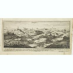
Bethlehem.
Magnificent bird's eye- of Bethlehem. Etched by Gaspar Bouttats (1640-1695).The Antwerp based publisher Jacques Peeters published ca. 1690 a series of prints related to t...
Date: Antwerp, c.1690
Jerusalem.
Magnificent bird's eye- of Jerusalem. Etched by Gaspar Bouttats (1640-1695).The Antwerp based publisher Jacques Peeters published ca. 1690 a series of prints related to t...
Date: Antwerp, c.1690
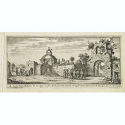
Gesicht in Jerusalem.
Magnificent bird's eye- of Jerusalem. Etched by Gaspar Bouttats (1640-1695).The Antwerp based publisher Jacques Peeters published ca. 1690 a series of prints related to t...
Date: Antwerp, c.1690
Tripoli de Soria.
Magnificent bird's eye- of Tripoli in Lebanon. Tripoli is located 85 km north of the capital Beirut, and is the easternmost port of Lebanon. Etched by Gaspar Bouttats (16...
- $100 / ≈ €87
Date: Antwerp, c.1690
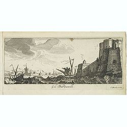
Gli Dardanelli.
Magnificent bird's eye- of Dardanelle street at the Aegean Sea. Etched by Gaspar Bouttats (1640-1695).The Antwerp based publisher Jacques Peeters published ca. 1690 a ser...
Date: Antwerp, c.1690
A. De Verualle Kerck Van Abakuck. . . .
Magnificent bird's eye- of Abakuck. Etched by Gaspar Bouttats (1640-1695).The Antwerp based publisher Jacques Peeters published ca. 1690 a series of prints related to the...
- $150 / ≈ €131
Date: Antwerp, c.1690
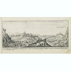
Het dal Terebinthus in Arabia.
Magnificent bird's eye- of Terebinthus north of Hebron. Etched by Gaspar Bouttats (1640-1695).The Antwerp-based publisher Jacques Peeters published ca. 1690 a series of p...
- $150 / ≈ €131
Date: Antwerp, c.1690
Satalia nel arcipelago. (Antalya)
Magnificent bird's eye-town-view of Antalya. Engraved by Lucas Vostermans II, who was born in 1624, in the same year when the family moved to England for six years. He wa...
- $150 / ≈ €131
Date: Antwerp, c.1690
Ladimistri nel arcipelago. (Edremit)
Magnificent bird's eye-town-view of Edremit on the west coast of Turkey, not far from the Greek island Lesbos. It is situated at the tip of the gulf with the same name (G...
- $150 / ≈ €131
Date: Antwerp, c.1690
Fanar nel Arcipelago. (Phanar)
Magnificent bird's-eye town-view of Fanar or Phanar, a neighborhood midway up the Golden Horn, within the district of Fatih in Istanbul. Engraved by Lucas Vostermans II, ...
- $150 / ≈ €131
Date: Antwerp, c.1690
Garde du corps de sa Hautesse. . .
Beautiful engraving by Henri Bonnart (1642?-1711) vis-à-vis les Mathurins au Coq. Printed with the privilege of the King.
Date: Paris, c. 1690
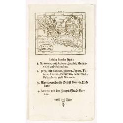
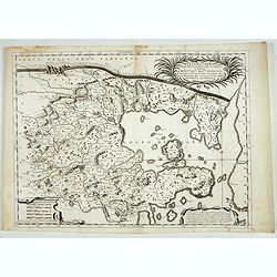
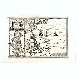
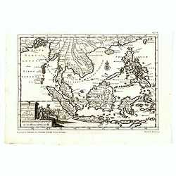
Insulae Sondae.
Rare small map of South East Asia, from "Kurtze bundige abbild und vorstellung der gantzen welt." by Johann Ulrich Muller. A second edition was published in Fra...
- $300 / ≈ €262
Date: Ulm, 1692
Estats de l'empire du grand seigneurs des turcs. . .
The map represents the Ottoman Empire based on Sanson's 1654 map. The Arabian Peninsula is shown with much detail including towns, villages, mountains and watercourses an...
Date: Amsterdam, 1692
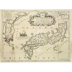
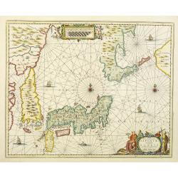
Isola del Giapone e penisola di Corea.
A most attractive and decorative map of Japan and its near neighbour Korea by Vincenzo Coronelli. An elaborate central title cartouche garlanded with intertwined flowers ...
Date: Venice, 1692
Iudaea seu terrasancta quae Hebraeorum sive Israelitarum. . .
Fine map of the Holy Land with a decorative title and scale cartouche.Alexis-Hubert Jaillot (1632-1712), was a French cartographer. He joined the Sanson heirs and redrew ...
Date: Amsterdam, 1692
Armenia Vetus In Quatuor Partes..
Uncommon Italian version of a map of ancient Armenia prepared by Philip de la Rue. The map describes the four regions of Armenia, Greater Armenia, Second, Third and Fourt...
Date: Padua, 1694
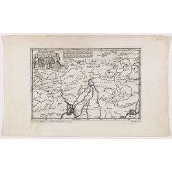
Tarku Urbs Tartaroum in Dagestan ad mare Caspium.
An early of Tarku, in the Republic of Dagestan. From the scarce Hamburg edition "Viel Vermehrte Moscowitische und Persianische Reisebeschreibung" by Adam Olear...
Date: Hamburg, 1696
![[East coast of Africa, Arabia and west coast of India.]](/uploads/cache/04762-250x250.jpg)
[East coast of Africa, Arabia and west coast of India.]
Rare. Map of the east coast of Africa, Including Madagascar, the Arabian Peninsular, coast of Pakistan and west coast of India.Prepared by Joao Teixeira in 1649, this cha...
Date: Paris, 1664-1696
Tarku Urbs Tartaroum in Dagestan ad mare Caspium.
An early view of Tarku, in the Republic of Dagestan. From the scarce Hamburg edition "Viel Vermehrte Moscowitische und Persianische Reisebeschreibung" by Adam ...
- $300 / ≈ €262
Date: Hamburg, 1696
Scythia et Tartaria Asiatica.
A decorative and interesting eighteenth century map of Tartary and Scythia from an atlas first published in Leiden in 1624. Philipp Clüverius (1580–1623) was virtually...
- $125 / ≈ €109
Date: Leiden, 1697
Imperii Sinarum Nova Descriptio.
Interesting map of China, shows the Great Wall, Macao and the Island of Formosa. From Philipp Clüver's famous Introductionis in Universam geographicam, first published i...
- $300 / ≈ €262
Date: Amsterdam, 1697
Xantung, e Peking provincie della china. . .
A beautiful map depicting the area of Beijing with decorative title cartouche and scale cartouche. Information about the area at the top of the map.To the right the west ...
- $350 / ≈ €306
Date: Venice, 1698

Accuratissima et maxima totius Turcici Imperii..
Rare issue of T. Danckert's attractive map showing the Arabian Peninsular, Turkey, Cyprus, Egypt and eastern part of the Mediterranean.Decorative title cartouche lower le...
Date: Amsterdam, 1700
A New Map of Great Tartary and China with the adjoining parts of Asia…
Two insets show the land to the northeast of China, according to Jesuit information. The map stretches from northern Russia and Nova Zemlya in the northwest to Formosa in...
Date: Oxford, 1700
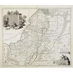
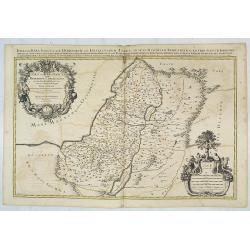
Het Heylige Land verdeeld in de twaalf stammen Israels ..
A fine map of the Holy Land depicting the tribes of Israel. A fine cartouche with Jesus preaching and healing. The scales with a cartographer and his pupil.
- $300 / ≈ €262
Date: Amsterdam, 1700
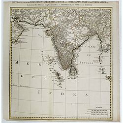
Carte d'une Partie des Indes Orientales, Etats du Mogol les Cotes de Malabar et de Coromandel.
A fine and highly detailed depiction of India and the surrounding region, this map extends from the Straits of Hormuz to the Gulf of Bengal. The Amsterdam publishing firm...
Date: Amsterdam, 1700
A New Map of Great Tartary and China with the adjoining parts of Asia
Two insets show the land to the northeast of China, according to Jesuit information. The map stretches from northern Russia and Nova Zemlya in the northwest to Formosa in...
Date: Oxford, 1700
Nova et accurata Japoniae terrae Esonis, ac Insularum adjacentium.
The map is of interest in showing Korea as a curiously shaped island and in revising the shape of the three main Islands of Japan. A re-issue of Janssonius' map with the ...
Date: Amsterdam, 1700
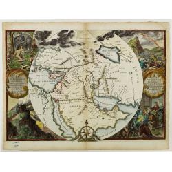
Orbis Per Creationem Institutus.
This is a very unusual map depicting the region from Asia Minor to India and including all of the Arabian Peninsula within a circle. The Garden of Eden is prominently dis...
- $750 / ≈ €655
Date: Amsterdam, 1700
![[Drawing of a Tulip]](/uploads/cache/06621-250x250.jpg)
[Drawing of a Tulip]
Very detailed and well-executed tulip drawing by an unknown artist attributed to the School of Anthony Claesz (1607/8-1649)This drawing was made for a 'Tulip book' painte...
- $1500 / ≈ €1310
Date: The Netherlands c.1700
![Bagdat le plan de Bagdat. [Manuscript plan of Bagdad]](/uploads/cache/45364-250x250.jpg)
Bagdat le plan de Bagdat. [Manuscript plan of Bagdad]
Manuscript plan of Baghdad, being a close copy of 'Les Six Voyages de Jean-Baptiste Tavernier en Turquie, en Perse et aux Indes' (1676). With a lettered key 1-16 to impor...
Date: France, ca. 1700

Collection of rubbings with portraits and biographies of famous Chinese philosophers, poets and legendary wise old men.
1701 - Stone rubbings of portraits and biographies of famous Chinese philosophers
- $15000 / ≈ €13103
Date: China or Korea, c. 1701
Nova Et Vera Exhibitio Gerographica Insularum Marianarum . . .
Attractive map of the Philippines, Japan, Korea and Indonesia with an inset of the island Guam, by the Jesuit Heinrich Scherer, printed in for Scherer's 'Atlas Novus'. Se...
- $1200 / ≈ €1048
Date: Munich, c.1702
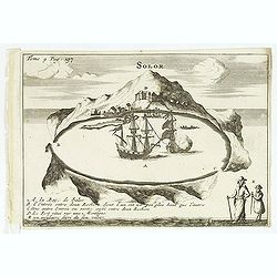
Solor / A la Baye de Solor.
Decorative map of the Bay of Solor. With a lettered key (A - E). Solor is a volcanic island located off the eastern tip of Flores island in the Lesser Sunda Islands of In...
- $120 / ≈ €105
Date: Amsterdam, E. Rogers, 1703
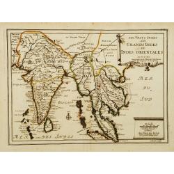
Les Vrays Indes dits Grands Indes ou Indes Orientales Par N. de Fer. Geographe de Sa Majeste Catoliques et de Monseigneur le Dauphin.
Detailed map on India, Thailand, the Malay Peninsular and the south coast of China up to Macao. The map was engraved by C. Inselin.
Date: Paris, 1703
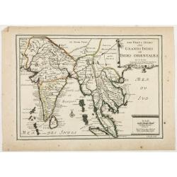
Les Vrays Indes dits Grandes Indes ou Indes Orientales Par N. de Fer. Geographe de Sa Majeste Catoliques et de Monseigneur le Dauphin.
Detailed map on India, Thailand, the Malay Peninsular and the south coast of China up to Macao. The map was engraved by C. Inselin.
Date: Paris, 1703
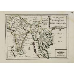
Les Vrays Indes dits Grands Indes ou Indes Orientales Par N. de Fer. Geographe de Sa Majeste Catoliques et de Monseigneur le Dauphin.
Detailed map on India, Thailand, the Malay Peninsular and the south coast of China up to Macao. The map was engraved by C. Inselin.
- $500 / ≈ €437
Date: Paris, 1703
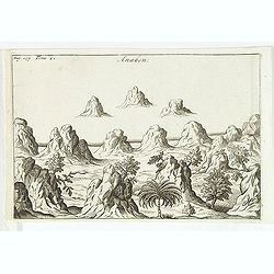
Anabon. (Ambon)
A fanciful view of a landscape on the island Ambon. From the French reissue of the account of early Dutch voyages first published in 1608 by Commelin. The French transla...
- $120 / ≈ €105
Date: Amsterdam, E. Rogers, 1703
La Baye de l'Isle & ville de Borneo.
Uncommon map of a Bay on the island of Borneo. From the French reissue of the account of early Dutch voyages first published in 1608 by Commelin. The French translation w...
- $100 / ≈ €87
Date: Amsterdam, E. Roger, 1703
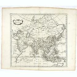
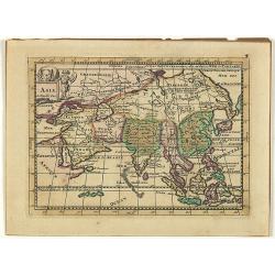
Asia.
Map of Asia. Peter Heylin or Heylyn (29 November 1599 – 8 May 1662) was an English ecclesiastic and author of many polemical, historical, political and theological trac...
- $450 / ≈ €393
Date: London, 1703

Description de l'Isle Formosa en Asie, du gouvernement, des
Complete title: Description de l'Isle Formosa en Asie, du gouvernement, des Moers & de la religion des habitans.Rare first French edition of one of the most famous fi...
Date: Amsterdam, 1705
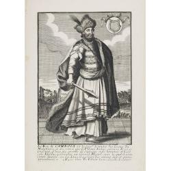
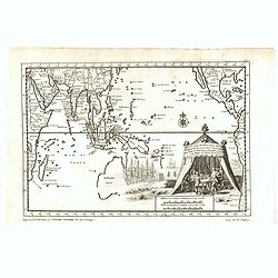
Le Roy de Camboia est le Seig.r de touts les Costes de Malabares, et des terres que le Fleuve Indus. . .
Very rare and decorative costume plate. Underneath the plate a descriptive text in French.Bears the address : A Paris chez F. Jollain l aine Rue St Jacques a la Ville de ...
- $200 / ≈ €175
Date: Paris, ca. 1685-1705
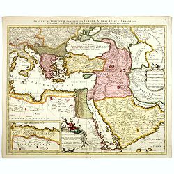
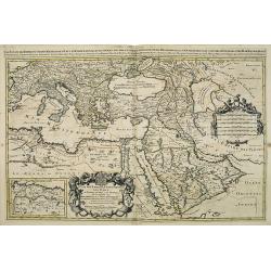
Imperium Turcicum Complectens Europae, Asiae, et Africae, Arabiae que Regiones ac Provincias Plurimas Industria et Labore . . .
Petrus Schenk's map of the Ottoman Empire, is based upon an earlier map by Sanson. It is showing from Italy to the Caspian Sea and the Saudi Peninsula, centered on Cyprus...
- $1000 / ≈ €874
Date: Amsterdam, circa 1705
Zee-Togt van den Grooten Turk Uyt het Roode Meyr Tegen de Portugy fen na Indien tot aan Kaap Comorin Ondernomen.
Map of the Arabian peninsula, with Saudi Arabia, the Indian Ocean and India and Ceylon.Although not renowned for the originality of his work, Pieter van der Aa is highly ...
Date: Leiden, 1706
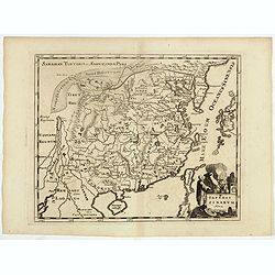
Carte de Tartarie.
Covering north east Asia, Tibet, Korea and part of "Terre d'Eso". Nova Zembla joined with the mainland.With good detail in Korea, several cities a labeled: Ch...
- $500 / ≈ €437
Date: Paris, 1706
Asia.
Uncommon map of Asia, with a curious shape for Korea. Nice title cartouche in upper left corner with an elephant and a warrior. From his atlas Oorlogs tablessen, Oft uytg...
- $300 / ≈ €262
Date: Amsterdam, 1706
Carte de Tartarie..
Uncommon Amsterdam edition covering north east Asia, Korea and part of "Terre d'Eso". Nova Zembla joined with the mainland. Showing the Caspian Sea with presen...
Date: Amsterdam, 1706
Reys-togt Thomas Coryat van Jerusalem te Land gedaan na Asmere de Hof-Stadt des Grooten Mogols in Oostindien.
The regional map illustrates the narrative of Thomas Coryat's travels by land from Jerusalem to the Court of the Great Mogul. Coryat travelled to Ajmer in India to the co...
- $450 / ≈ €393
Date: Leiden, 1706
Carte de Tartarie.
Rare first edition "Chez l'Auteur Rue des Canettes préz de St. Sulpice". The "Rue des Canettes" address appears on the original versions of maps date...
Date: Paris, 1706
Indien onder den Heer Lopo Vaz De Sampayo, als Gouverneur Generaal tot aan Nieuw-Spanje in American on Kusten van Peru en Chili bevaaren.
Most decorative and scarce item, centred on Indonesia, including an incomplete coast of Australia, and west coast of America. The South Pacific is occupied by a large tit...
Date: Leiden, 1707
D'Indize kusten van Bengale, Pegu, Malacca en Siam Tot in China. . .
Map of Indonesia, Malacca with Singapore (Cingapura) and Taiwan in upper right corner. In lower left a fine title cartouche showing Duarte de Menezes.Although not renowne...
Date: Leiden, 1707
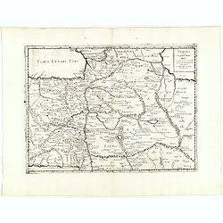
De Land-Reyse, door Benedictus Goes, van Lahor gedaan, door Tartaryen na China.
Interesting map showing the region of northeastern India, Nepal, Bhutan, Assam and Bangladesh. Canton in lower right corner.The map illustrates the narrative of the trave...
- $200 / ≈ €175
Date: Leiden, 1707
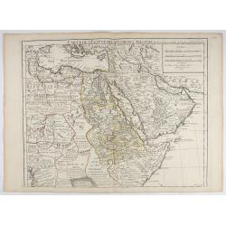
Carte de L'Egypte de la Nubiede L'Abissinie. . .
Including the Arabian Peninsula. Giving good detail on Egypt. Engraved by Desrosiers.More about Mapping of Arabia [+]
- $300 / ≈ €262
Date: Paris, 1707
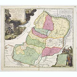
IUDAEA seu PALAESTINA... TERRA SANCTA... IUDA et ISRAEL
Map of Palestine divided among the Tribes, drawn by Homann after Guillaume Sanson. The shoreline runs from Sidon as far as Rinocorura. The Kishon River is shown as connec...
- $500 / ≈ €437
Date: Nuremberg, 1707
