Browse Listings in Asia
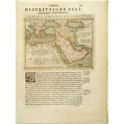
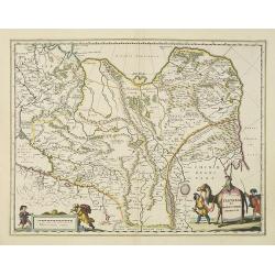
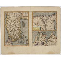
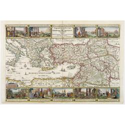
Turcici Imperii descriptio.
Finely and early map of the Turkish Empire giving good detail in the Arabian Peninsula. From Isolario, engraved by Girolamo Porro.Read more about Mapping of Arabia and o...
Date: Padua 1620
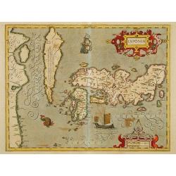
Japonia.
Jodocus Hondius' fine map early 17th-century map of the islands of Japan, was first issued as one of the new maps in the expended Mercator Hondius Atlas of 1606.The map i...
Date: Amsterdam, 1606-1620
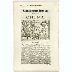
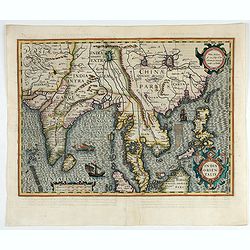
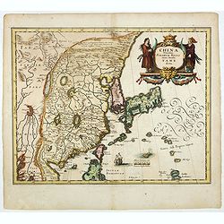
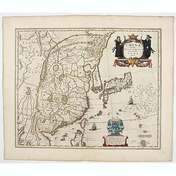
China.
Small map illustrating China with the Great Wall and Korea as an island, surrounded by text in Dutch.Nicolaes de Clerck (de Klerc) was active as engraver and publisher in...
- $200 / ≈ €175
Date: Amsterdam, Cloppenburch, 1621
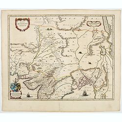
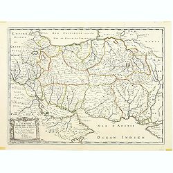
Bengala.
Small map centered on the Bay of Bengal, surrounded by text in Dutch. Nicolaes de Clerck (de Klerc) was active as engraver and publisher in Delft from 1599-1621.Included ...
- $150 / ≈ €131
Date: Amsterdam, Cloppenburch, 1621
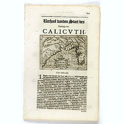
Malabar.
Small map illustrating the southwestern sea coast of India. Oriented with East on top, surrounded by text in Dutch.Included in the rare book : Wereld Spiegel, waer in ver...
- $200 / ≈ €175
Date: Amsterdam, Cloppenburch, 1621
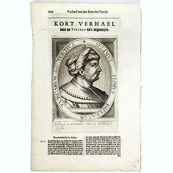
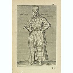
Selimus Primus Imperator Turcarum decimus Tertius.
The engraving depicts a half length oval portrait of Selim I, who was the Sultan of the Ottoman Empire from 1512 to 1520. His reign is notable for the enormous expansion ...
- $30 / ≈ €26
Date: Amsterdam, Cloppenburch, 1621
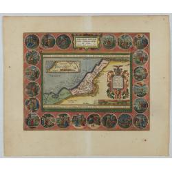
Abrahami Patriarchae Peregrinatio et Vita.
The Holy Land map itself occupies the center and is surrounded by vignettes of the life of the Patriarch Abraham. Extremely decorative map made by Ortelius, based on Ptol...
Date: Antwerp, 1624
![[Atrii Sancti ac Tabernaculi Foederisorthographia].](/uploads/cache/26474-250x250.jpg)
[Atrii Sancti ac Tabernaculi Foederisorthographia].
Campment in Israel.From an uncommon edition of Kerckelycke Historie van Neder-Landt which was a Dutch text edition of Agostino Torniello's Annales Sacri et Profani by Her...
- $50 / ≈ €44
Date: Holland, ca. 1625
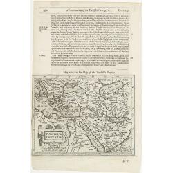
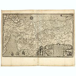
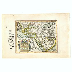
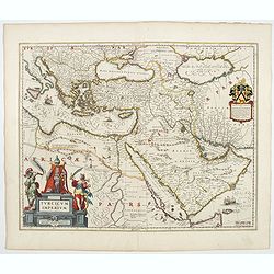
Turcicum Imperium.
The rare Samuel Purchas' edition of the Mercator / Hondius "Atlas Minor" atlas map. Early map of Turkey, the Arabian pen insular and eastern part of the Mediter...
Date: London, 1625
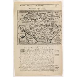
Persicum Regnum.
The rare Samuel Purchas' edition of the Mercator/Hondius Atlas Minor atlas map. Early map of Turkey, including Cyprus published in his famous collection of voyages His Pi...
- $115 / ≈ €100
Date: London, 1625
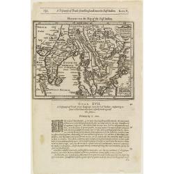
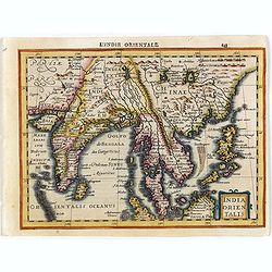
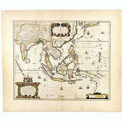
India Orientalis.
The rare Samuel Purchas' edition of the Mercator/Hondius Atlas Minor atlas map. Thisearly map of the East Indies was published in his famous collection of voyages His Pil...
- $300 / ≈ €262
Date: London, 1625
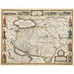
The Kingdom of Persia with the cheef Citties and Habites described by John Speede.
One of the most decorative "carte à figures"- maps of the old Kingdom of Persia, including modern day Iran and Iraq, as well as portions of the Turkish Empire,...
- $2000 / ≈ €1747
Date: London, G.Humble, 1626
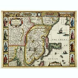
The Kingdome of China.
A most sought-after map of China. Decorative border vignettes including views of the cities of Quinzay and Macao along the top border with the wheeled wind machines and p...
Date: London, G. Humble, 1626
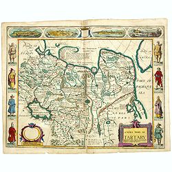
A newe mape of Tartary.
Early edition of one of the most decorative maps of Tartary, known for its figured borders with costume figures, while above are vignettes of the cities of Astrakhan, Sam...
- $2500 / ≈ €2184
Date: London, 1627

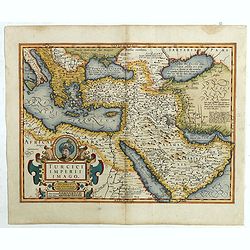
Turcici Imperii Imago.
The map shows the Ottoman Empire with Turkey, Black Sea, Mediterranean Sea, Arabia and North Eastern Africa. The map is decorated with a title cartouche and a portrait of...
Date: Amsterdam, 1629
India Orientalis.
Map covering India, Thailand, Philippines, Northern Borneo and the coast of Southern China. From the rare Cloppenburg edition "Atlas Sive Cosmographicae Meditationes...
- $550 / ≈ €480
Date: Amsterdam, 1630
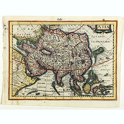
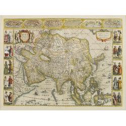
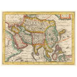
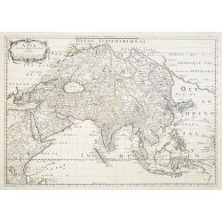
Asia.
Asia map from the rare Cloppenburg edition slightly larger format and more scarce edition of the Mercator/Hondius "Atlas Minor". Engraved by Pieter Van Den Keer...
Date: Amsterdam, 1630
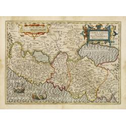
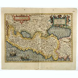
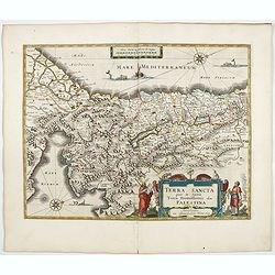
Terra Sancta que in Sacris Terra Promissionis ol: Palestina.
This map of Palestine extending from the Lebanon mountains to the Dead Sea is based on the large map by P.Laicksteen and Chr.'s-Grooten in the latter part of the sixteent...
Date: Amsterdam, 1630
Terra Sancta que in Sacris Terra Promissionis ol: Palestina
This map of Palestine extending from the Lebanon mountains to the Dead Sea is based on the large map by P.Laicksteen and Chr.'s-Grooten in the latter part of the sixteent...
- $900 / ≈ €786
Date: Amsterdam, 1630
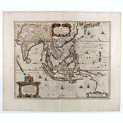
India Orientalis.
Published in Hondius' editions of the Mercator Atlas from 1606 onwards, showing the Indian subcontinent, the Malay Peninsula, Siam and Cambodia, China and the Philippines...
Date: Amsterdam, 1630
Pere Grinatie. De Reijse der Kinderen Israels so zij wt Egip . . .
Scarce separately engraved map of the Holy Land by Joannes van Doetecum Jr.In the lower right corner, inset with a title cartouche surrounded by Aaron, the encampment of ...
Date: Amsterdam, 1598, The Hague, 1632
Asia recens summa cura delineata.
This is the rare early issue with decorative paneled borders. In upper border views and plans of Famagusta, Rhodos, Damascus, Jerusalem, Aden and Ormus. Originally engrav...
Date: Amsterdam, 1632
Asia.
Early map of Asia, including Korea as in peninsular.
Date: Amsterdam, 1632
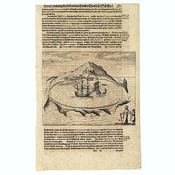
Solor.
Scarce print on German text sheet showing the Island of Solor. From "Petits Voyages". The island Solar, to the north of Timor, has a high mountain and has a ver...
- $100 / ≈ €87
Date: Frankfurt, M.Merian, 1633
Turcici Imperii Imago.
A very decorative map. On top of title cartouche the portrait of Sultan Mahumet Turcorum Imperat .More about Mapping of Arabia [+]
- $1000 / ≈ €874
Date: Amsterdam, 1633
![Les Petit Voyages [Solor].](/uploads/cache/37958-250x250.jpg)
Les Petit Voyages [Solor].
This work by de Bry comprises probably the greatest single collection of material on early voyages to the East Indies, and are unique in their extraordinary wealth of car...
- $100 / ≈ €87
Date: Frankfurt, 1601 - 1633
![[The Dutch reach Annabon.]](/uploads/cache/40075-250x250.jpg)
[The Dutch reach Annabon.]
Eight days after leaving the mainland, the Dutch arrived at one of the Annabon islands (Pagalu), where they asked the Portuguese and Moors, who were occupying the island,...
Date: Frankfurt, M.Merian, 1633
Turcicum Imperium.
Early map of Turkey, the Arabian peninsula and eastern part of the Mediterranean.From the English edition of Mercator's Atlas Minor. This edition 1635. English text on ve...
Date: Amsterdam, 1635

Constantinopolitanae urbis effigies ad vivum expressa, quam Turcae Stampoldam vocant. A° MDCXXXV.
Large, decorative view of the city of Constantinople, with legend across the bottom. It is beautifully engraved with quaint scenes of everyday life, including hunters wit...
Date: Frankfurt, 1635
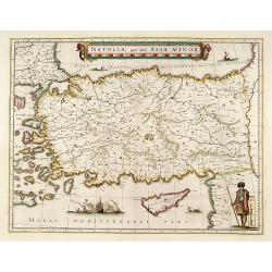
Natolia, quae olim Asia minor.
A finely designed map of Turkey and Cyprus from the great Blaeu family of Amsterdam. The decoration consist of a colored title cartouche, sea monsters, a naval engagement...
Date: Amsterdam, 1635
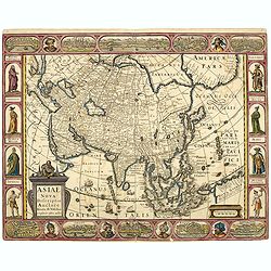
Asiae Nova Descriptio.
Final State of Pieter Van Den Keere's Rare Map of Asia -- The first map of Asia to include decorative panels. Published by N.J.Visscher and engraved by Abraham Goos, embe...
Date: Amsterdam, 1636
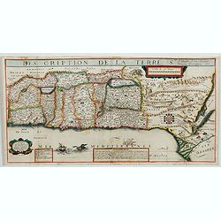
Description de la Terre Ste a laquelle A esté adjouté Diverses Observations 1637.
Very rare map of the Holy Land published by Jean Boisseau and engraved by H. Picart in Paris. "A Paris Chez Iean Boisseau en lisle du Palais sur le quay qui regarde ...
- $2500 / ≈ €2184
Date: Paris, 1637
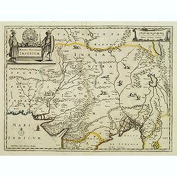
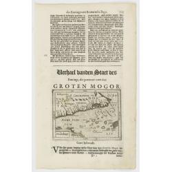
Magni Mogolis Imperium.
An attractive map of northern part of India, Tibet, Iran to Burma. The travel route from Kabul to Surat is the most prominent feature of the map. Richly decorated with st...
- $500 / ≈ €437
Date: Amsterdam, after 1638
Tartaria sive Magni Chami imperium.
Detailed and decorative map of Tartary and Northern part of China. Northern tip of Korea included. The Chinese Great Wall is depicted, with Central Asia, extending from M...
- $500 / ≈ €437
Date: Amsterdam, 1638
India quae Orientalis dicitur, et Insulae Adiacentes.
Map of South East Asia, noteworthy for being one of the first maps to include, albeit incompletely, the discoveries made by the Dutch vessel Duyfken in 1605-1606 in the G...
- $1750 / ≈ €1529
Date: Amsterdam, 1638
China Veteribus Sinarum Regio nunc Incolis Tame dicta.
Fine map of China, based on the first of Blaeu's maps of China. In the west by the Great Wall is shown, among Taiwan is named Pakan al I. Formosa, although Tayoan is name...
- $950 / ≈ €830
Date: Frankfurt am Main, 1638

Carte de l'Asie, corrigée et augmentée, dessus toutes les aultres Faict L année 1640.
Map of Asia with a dedication to Pierre Petit. The map bears a very close resemblance to the Asia maps of the Hondius family. Michael Van Lochom (1601-1647) was a Calvini...
Date: [Paris], 1640

Asia secunda pars terrae in forma Pegasi.
Asia is depicted as the flying horse Pegasus. This cartographical curiosity, double-page copper engraved map, was published in Heinrich Bünting's “Itinerarium Sacrae S...
Date: Brunswick, 1640
India quae Orientalis dicitur, et Insulae adiacentes.
A fine map of South East Asia, extending from India to Tibet to Japan to New Guinea. Formosa appears on this map, and even parts of Japan and Australia are seen. A handso...
- $1850 / ≈ €1616
Date: Amsterdam, 1640
Natoliae.. Aegypti recentior.. Carthaginis (3 maps on 1 sheet)
Map to the left east to the top. Detailed map Turkey, including Cyprus and Crete. Also map of the Nile delta and another map of Tunis. From "Theatrum Orbis Terrarum&...
Date: Antwerp, 1609-1641
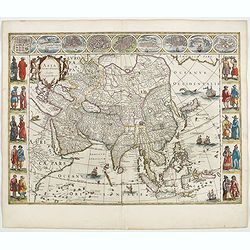
Asia noviter delineata. . .
From 1633 the members of the Blaeu family were official cartographers to the United East India Company and, as such, had access to the most up-to-date cartographic inform...
Date: Amsterdam, 1644
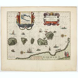
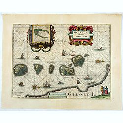
Moluccae Insulae Celeberrimae.
Showing the geographical features of the islands, and decorated with ships, sea monsters and a handsome cartouche. With an inset of Bachian island. From early on Willem ...
- $750 / ≈ €655
Date: Amsterdam, 1644
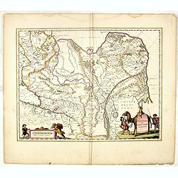
Magni Mogolis Imperium.
An attractive map of the region from Iran through Afghanistan, Tibet, and northern India across to Burma. The travel route from Kabul to Surat is the most prominent featu...
- $350 / ≈ €306
Date: Amsterdam, 1644
China Veteribus Sinarum Regio.
This was the first of Blaeu's maps of China. In 1655 he was to publish the famous map of Father Martini, with many of the earlier inaccuracies present on this map correct...
- $2200 / ≈ €1922
Date: Amsterdam, 1644
Turcicum Imperium.
A very handsome map with a particularly fine cartouche showing the Turkish Sultan on his throne and allegorical figures at either side brandishing weapons. At the right i...
- $1800 / ≈ €1572
Date: Amsterdam, 1644
TERRA SANCTA quae in Sacris Terra Promissionis...
The Holy Land, Promised Land or Palestine. Oriented to the west. Shows the entire Palestine on both sides of the Jordan, the shore line running from Tripoli as far as the...
- $1000 / ≈ €874
Date: Amsterdam, 1644
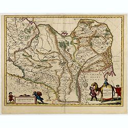
Tartariae sive Magni Chami Imperium.
Fine map of Tartary, including northern part of China, and tip of Korea.
- $500 / ≈ €437
Date: Amsterdam, 1645
Tartaria sive Magni Chami Imperium.
Detailed and decorative map of Tartary and Northern part of China. Northern tip of Korea included. The Chinese Great Wall is depicted, with Central Asia, extending from M...
- $550 / ≈ €480
Date: Amsterdam, 1645
Moluccae Insulae Celeberrimae.
Showing the geographical features of the islands and decorated with ships, sea monsters and a handsome cartouche. With an inset of Bachian island. From early on Willem J...
- $750 / ≈ €655
Date: Amsterdam, ca.1645
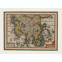
Asia.
This lovely rare miniature map of the continent of Asia is a single page with text on verso taken from John Speed's folio atlas, and is signed with Van den Keere's Latini...
- $275 / ≈ €240
Date: London, 1646
![Ins. de Cerno a. Nostatibus Mauritius Nominata [on sheet with] Gunnanappi Labetacq [and] Civitas Gammelamme [and] Rex Tubatus.](/uploads/cache/48504-250x250.jpg)
Ins. de Cerno a. Nostatibus Mauritius Nominata [on sheet with] Gunnanappi Labetacq [and] Civitas Gammelamme [and] Rex Tubatus.
Three views and one map on one page: Shows natives on Mauritius fishing and building a boat, with a dodo and two turtles at right; The Banda islands; A procession for th...
Date: Amsterdam, c.1646
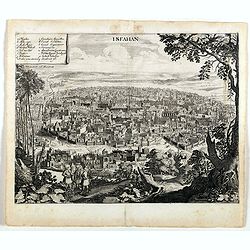
Isfahan.
An early of Isfahan in central Iran,. From the rare first edition "Offt begehrte Beschreibung der newen orientalischen Rejse, so durch Gelegenheit einer Holsteinisc...
- $250 / ≈ €218
Date: Schleßwig, Zur Glocken, 1647
Geographische Beschryvinge van de wandeling der Apostelen. . .
Finely engraved detailed map covering the whole of the eastern Mediterranean. Showing the travels of the apostles after the death of Christ, with episodes from the life o...
Date: Amsterdam, 1648
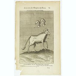
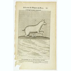
De la Ruine de l'Empire des Turcs Quatriesme figure / Epigramme de la Quatriesme figure. (85)
Sought-after copper engraved plate taken from Laonikos Chalcocondyle’s "L'histoire de la décadence de l'empire grec et establissement de celuy des Turcs", th...
- $50 / ≈ €44
Date: Paris, Mathieu Guillemot, 1650
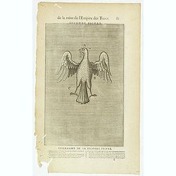
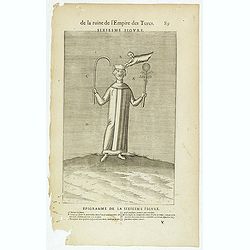
De la Ruine de l'Empire des Turcs Seconde figure / Epigramme de la Seconde figure. (81)
Sought-after copper engraved plate taken from Laonikos Chalcocondyle’s "L'histoire de la décadence de l'empire grec et establissement de celuy des Turcs", th...
- $50 / ≈ €44
Date: Paris, Mathieu Guillemot, 1650
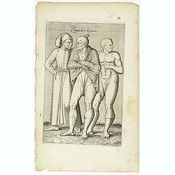
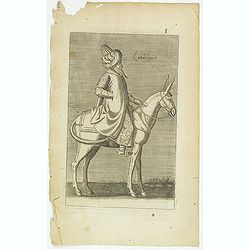
Femme de la Caramanie. (57)
Sought-after copper engraved plate taken from Laonikos Chalcocondyle’s "L'histoire de la décadence de l'empire grec et establissement de celuy des Turcs." by...
- $50 / ≈ €44
Date: Paris, Mathieu Guillemot, 1650
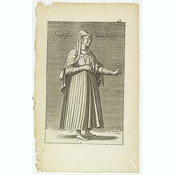
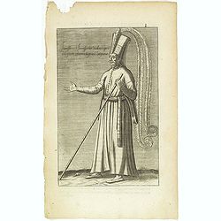
Gentille Femme Perotte Franque. (48)
Sought-after copper engraved plate of a woman from Pera, taken from Laonikos Chalcocondyle’s "L'histoire de la décadence de l'empire grec et establissement de cel...
- $100 / ≈ €87
Date: Paris, Mathieu Guillemot, 1650
(Grand dame Turque. 45)
Sought-after copper engraved plate of a woman from Turkey. Plate from Laonikos Chalcocondyle’s "L'histoire de la décadence de l'empire grec et establissement de c...
Date: Paris, Mathieu Guillemot, 1650
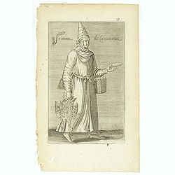
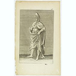
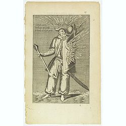
Religieux Turc. (26)
Sought-after copper engraved plate taken from Laonikos Chalcocondyle’s "L'histoire de la décadence de l'empire grec et establissement de celuy des Turcs." by...
Date: Paris, Mathieu Guillemot, 1650
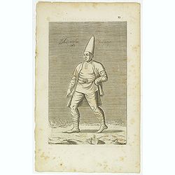
Torlaqui Religieux Turc. ( 25 )
Sought-after copper engraved plate taken from Laonikos Chalcocondyle’s "L'histoire de la décadence de l'empire grec et establissement de celuy des Turcs." by...
Date: Paris, Mathieu Guillemot, 1650
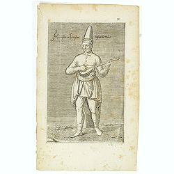
Cuisinier Turc. (19)
Sought-after copper engraved plate taken from Laonikos Chalcocondyle’s "L'histoire de la décadence de l'empire grec et establissement de celuy des Turcs." by...
Date: Paris, Mathieu Guillemot, 1650
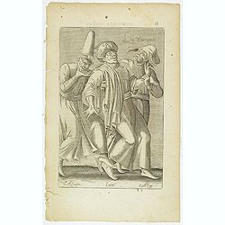
Les Yurongnes. (18)
Sought-after copper engraved plate taken from Laonikos Chalcocondyle’s "L'histoire de la décadence de l'empire grec et establissement de celuy des Turcs." by...
Date: Paris, Mathieu Guillemot, 1650
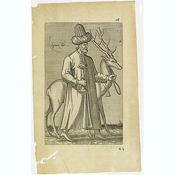
Delli de nation Parthique qui signifie Sol Harfy ou Enfant Perdu. (17)
Sought-after copper engraved plate taken from Laonikos Chalcocondyle’s "L'histoire de la décadence de l'empire grec et establissement de celuy des Turcs." by...
- $50 / ≈ €44
Date: Paris, Mathieu Guillemot, 1650
Pleuianders Luyteurs. (16)
Sought-after copper engraved plate taken from Laonikos Chalcocondyle’s "L'histoire de la décadence de l'empire grec et establissement de celuy des Turcs." by...
- $50 / ≈ €44
Date: Paris, Mathieu Guillemot, 1650
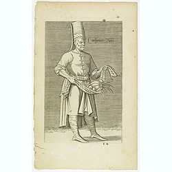
Azamoglan Rustique .(12)
Sought-after copper engraved plate taken from Laonikos Chalcocondyle’s "L'histoire de la décadence de l'empire grec et establissement de celuy des Turcs." by...
Date: Paris, Mathieu Guillemot, 1650
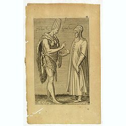
Azaoglan ou Iamoglan Enfant du tribut. (11)
Sought-after copper engraved plate taken from Laonikos Chalcocondyle’s "L'histoire de la décadence de l'empire grec et establissement de celuy des Turcs." by...
- $50 / ≈ €44
Date: Paris, Mathieu Guillemot, 1650
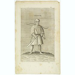
Azzappi. (10)
Sought-after copper engraved plate from Laonikos Chalcocondyle’s "L'histoire de la décadence de l'empire grec et establissement de celuy des Turcs." by Thoma...
- $50 / ≈ €44
Date: Paris, Mathieu Guillemot, 1650
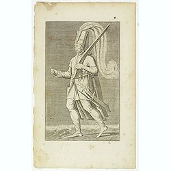
Iannissaire Allant à la Guerre. (9)
Sought-after copper engraved plate from Laonikos Chalcocondyle’s "L'histoire de la décadence de l'empire grec et establissement de celuy des Turcs." by Thoma...
Date: Paris, Mathieu Guillemot, 1650
Iannissaire ou Ianissarler Soudart a Pied de la Garde Ordinaire du Grand Seigneur. (8)
Sought-after copper engraved plate from Laonikos Chalcocondyle’s "L'histoire de la décadence de l'empire grec et establissement de celuy des Turcs." by Thoma...
Date: Paris, Mathieu Guillemot, 1650
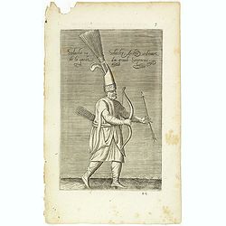
Solachi ou Solacler, Archer Ordinaire de la Garde du Grand Seigneur. (7)
Sought-after copper engraved plate taken from Laonikos Chalcocondyle’s "L'histoire de la décadence de l'empire grec et establissement de celuy des Turcs." by...
Date: Paris, Mathieu Guillemot, 1650
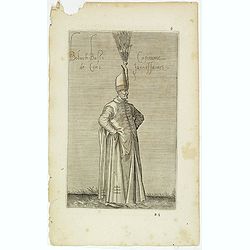
Boluch Bassi Capitaine de Cent Janissaires. (6)
Sought-after copper engraved plate from Laonikos Chalcocondyle’s "L'histoire de la décadence de l'empire grec et establissement de celuy des Turcs." by Thoma...
Date: Paris, Mathieu Guillemot, 1650
Calidesquer. (5)
Sought-after copper engraved plate from Laonikos Chalcocondyle’s "L'histoire de la décadence de l'empire grec et establissement de celuy des Turcs." by Thoma...
Date: Paris, Mathieu Guillemot, 1650
De la Ruine de l'Empire des Turcs Cinquiesme figure / Epigramme de la Cinquiesme figure. (87)
Sought-after copper engraved plate taken from Laonikos Chalcocondyle’s "L'histoire de la décadence de l'empire grec et establissement de celuy des Turcs", th...
- $50 / ≈ €44
Date: Paris, Mathieu Guillemot, 1650
De la Ruine de l'Empire des Turcs Sixiesme figure / Epigramme de la Sixiesme figure. (89)
Sought-after copper engraved plate taken from Laonikos Chalcocondyle’s "L'histoire de la décadence de l'empire grec et establissement de celuy des Turcs", th...
- $50 / ≈ €44
Date: Paris, Mathieu Guillemot, 1650
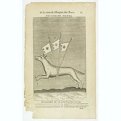
De la Ruine de l'Empire des Turcs Huictiesme figure / Epigramme de la Huictiesme figure. (93)
Sought-after copper engraved plate taken from Laonikos Chalcocondyle’s "L'histoire de la décadence de l'empire grec et establissement de celuy des Turcs", th...
- $50 / ≈ €44
Date: Paris, Mathieu Guillemot, 1650
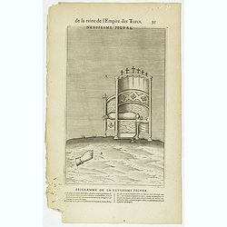
De la Ruine de l'Empire des Turcs Neufiesme figure / Epigramme de la Neufiesmie figure. (95)
Sought-after copper engraved plate taken from Laonikos Chalcocondyle’s "L'histoire de la décadence de l'empire grec et establissement de celuy des Turcs", th...
- $25 / ≈ €22
Date: Paris, Mathieu Guillemot, 1650
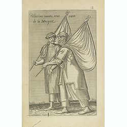
Pellerins mores, reue nuns de la Mecque.
Sought-after copper engraved plate from Laonikos Chalcocondyle’s "L'histoire de la décadence de l'empire grec et establissement de celuy des Turcs." by Thoma...
Date: Paris, Mathieu Guillemot, 1650
Femme Turque de moyen estat En chambre. (42)
Sought-after copper engraved plate from Laonikos Chalcocondyle’s "L'histoire de la décadence de l'empire grec et establissement de celuy des Turcs." by Thoma...
Date: Paris, Mathieu Guillemot, 1650
Description de l'Empire du Sophi des Perses tiree en partie de l'Arabe de Nubie, et en partie de plusieurs et diverses Relations.
The map of the Empire of Persia is shown to extend from Baghdad almost to the present-day borders of India. Including part of Saudi Arabia and Oman. Including "Golfe...
Date: Paris, 1650
Asie.
Map of Asia still showing Corey as an island. Including America's West Coast.More about Western mapping of Korea maps. [+]
- $500 / ≈ €437
Date: Paris, 1650
